Grazing News

Two items of note involving grazing on federal lands, via the Public Lands Council:

Grazing permits: Voluntary Grazing Permit Retirement Act threatens land use, Wyoming Livestock Roundup – On March 3, Reps. Adam Smith (D-Wash.) and Jared Huffman (D-Calf.) released statements following the proposed bill of the Voluntary Grazing Permit Retirement Act. The bill gives grazing permit holders the option to waive their grazing permits on federal lands in return for compensation. The bill was first introduced in the House of Representatives on Jan. 30, 2020. The bill was referred to the House Committee on Natural Resources by the House of Representatives and then referred to the Subcommittee on National Parks, Forests and Public lands on Feb. 3, 2020.

Groups halt grazing in Elkhorn Mountains, Daily Montanan – Alliance for the Wild Rockies and Native Ecosystems Council successfully halt grazing and sagebrush-juniper burning in the Elkhorn Mountains Wildlife Management Area. A federal district court ruled in favor of the Alliance for the Wild Rockies and Native Ecosystems Council in a lawsuit to force the Bureau of Land Management to conduct an adequate environmental analysis before grazing and burning in the Iron Mask Acquisition area of the Elkhorn Mountains. The court’s March 14 order mandates additional analysis, as required by the National Environmental Policy Act, and requires the agency to analyze if existing agency-installed fences and water developments for cattle grazing should be removed.

Forest Restoration: Old-Growth Management

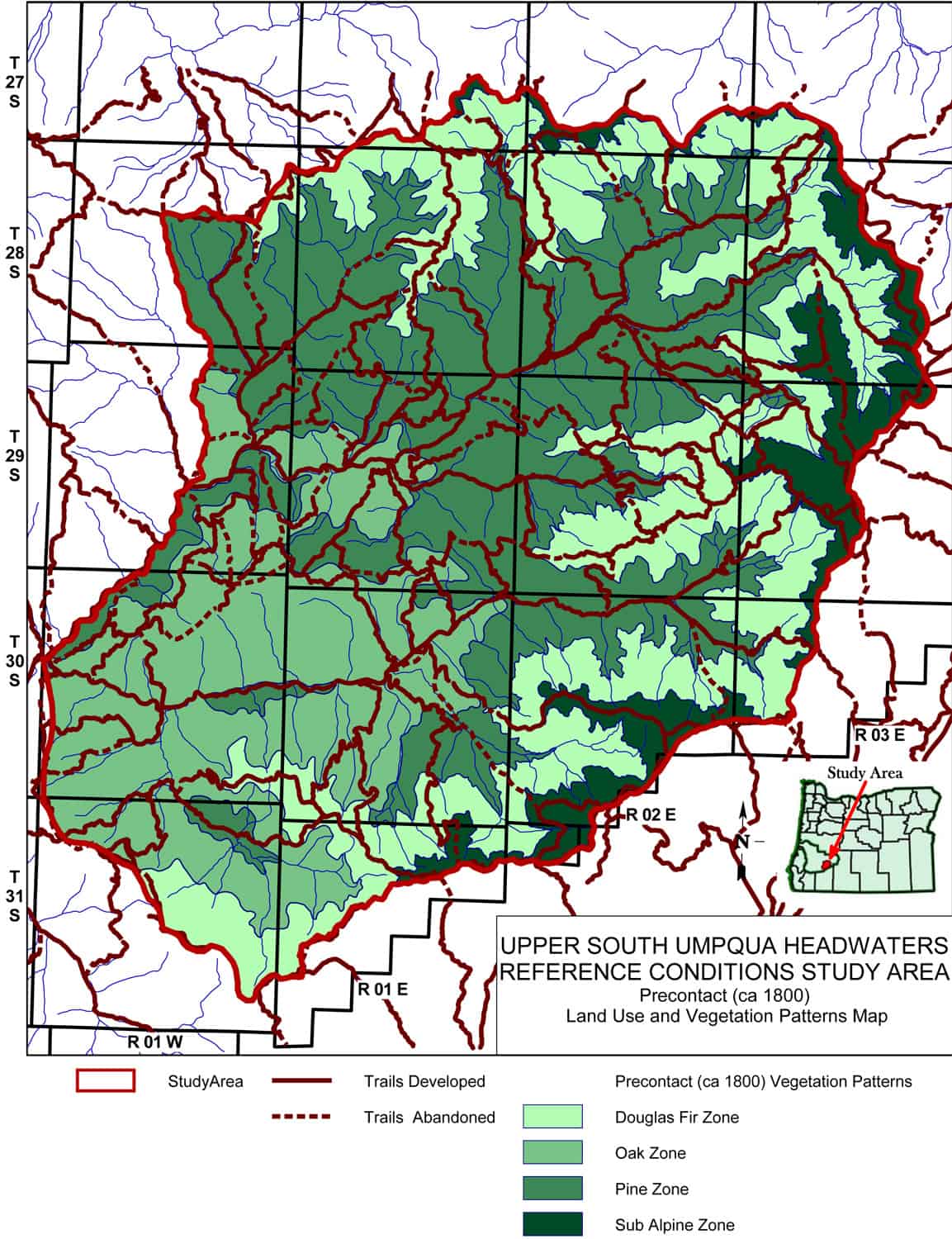
The following map and photos are from a research project I completed a little more than 10 years ago. Management of old-growth trees for their preservation begins with their definition and location. Competition and crown fires are among the greatest apparent threats: http://www.orww.org/Osbornes_Project/Rivers/Umpqua/South/Upper_Headwaters_Project/ca_1800_Forest_Zones/

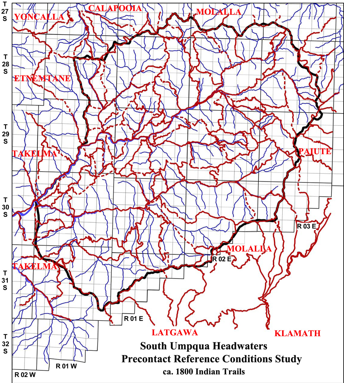
The 2010 “Upper South Umpqua Headwaters Precontact Reference Conditions Study” was authorized by the Douglas County Board of Commissioners, in cooperation with the USDA Umpqua National Forest and the Cow Creek Band of Umpqua Tribe of Indians. Research focus was to determine approximate forest conditions for the study area during the 1800 to 1825 time period. Primary sources of information included General Land Office original land survey notes and maps from 1857 to 1938, historical photos from 1899 to 1944, historical maps from 1900 to 1970, Osborne fire lookout panoramas from 1932 to 1938, aerial photos from 1939 to 1945, and nearly 3000 comprehensive documentary photographs in 2010. From these sources a series of GIS maps were constructed by the Douglas County Surveyors Office and developed into likely vegetation and trail maps for the ca. 1800 to 1825 time period.

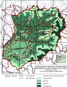
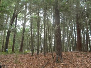
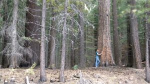
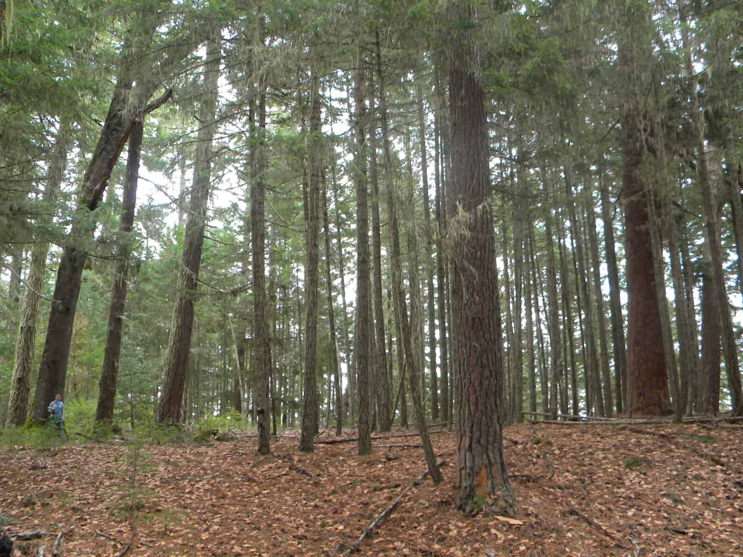
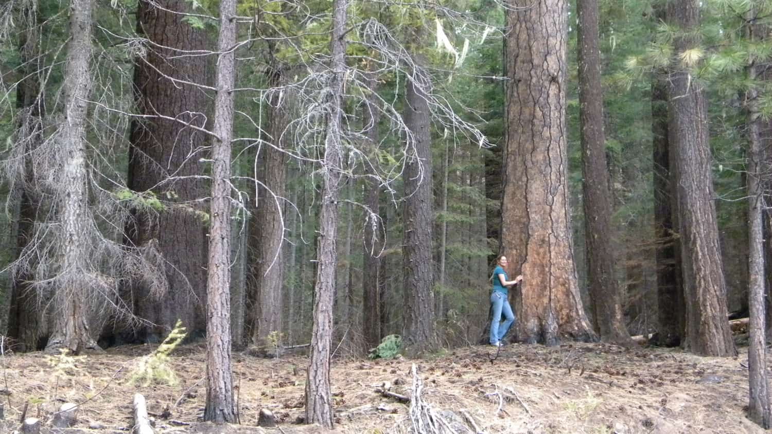
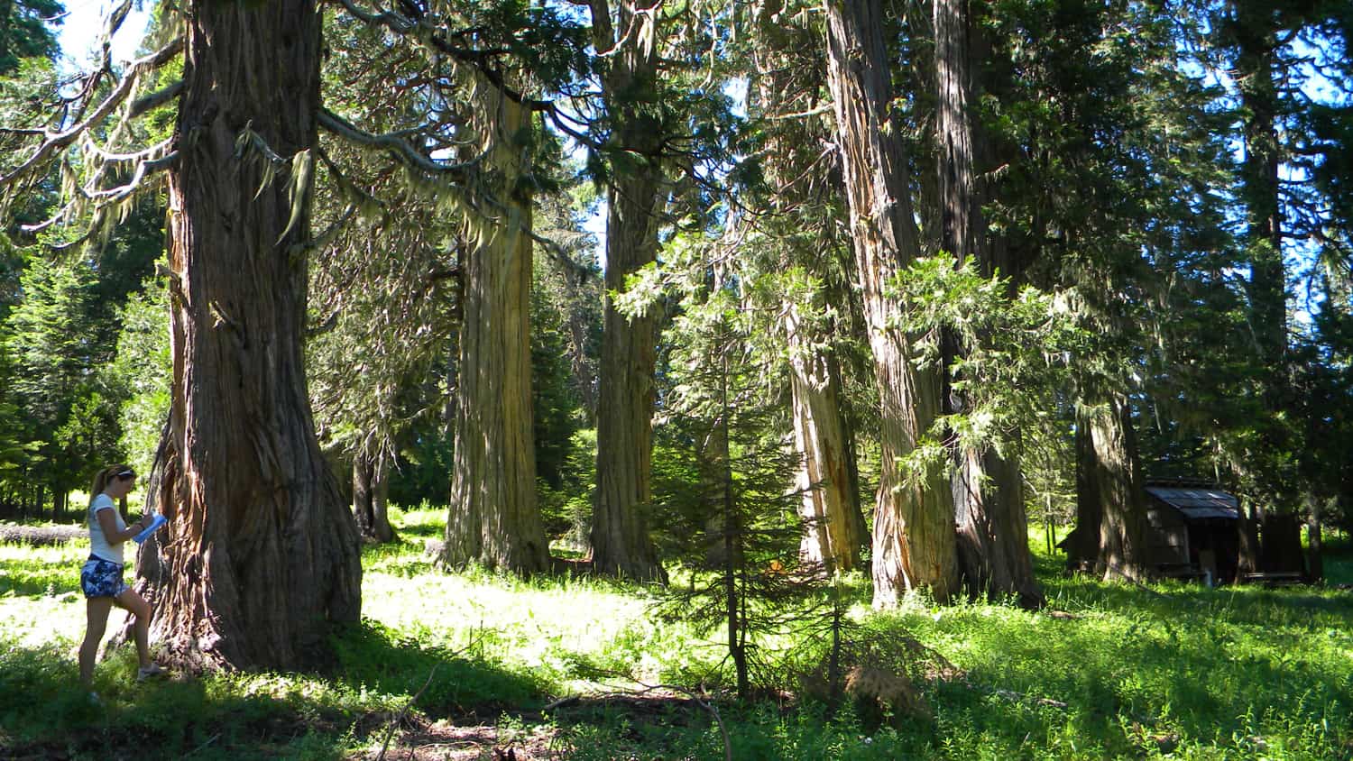
Through this process it was determined that four basic types, or “zones,” of vegetation existed prior to white contact and decimation of local communities by introduced diseases. These four types can be delineated by elevation and corroborated by the existence of old-growth trees and other persistent vegetation patterns in excess of 200 years of age. In each of the following photographs, research assistant Nana Lapham serves as a human scale to an old-growth representative of an earlier forest condition. The Oak Zone photo features a lower elevation 200+ year old black oak in a former oak and pine savannah; the Pine Zone photo shows an old-growth sugar pine, likewise in a former savannah, at a higher elevation; the Douglas Fir Zone photo shows the transition from lower elevation pine to higher elevation Douglas fir, and indicates the much lower density of trees 200 years ago; and the Subalpine Zone photo shows old-growth cedar and young true fir saplings in the highest areas of the study area.

Oak Zone   This photo shows old-growth relict pine and oak with invasive Douglas fir on Pickett Butte in 2010. Relatively young white oak, black oak, and pine savannahs, extensive grassland meadows and prairies, and patches of similarly much younger Douglas fir, redcedar, and pine typified much of the western and lower elevation (below 2,400 feet) portions of the study area 200 years ago. The presence and arrangements of these plants, as well as widespread populations of camas, cat’s ears, fawn lilies, iris, tarweed, yampah, and hazel, indicate regular systematic use of the landscape by people – most likely mostly Takelman-speakers — at that time. The average number of trees larger than saplings per acre was probably ten or less. Human occupation of this zone was likely year-round, with relatively large seasonal villages and campgrounds near the mouth of Jackson Creek and at South Umpqua Falls: two locations that (according to historical reports) were heavily used during times of anadromous salmonid and lamprey eel runs.

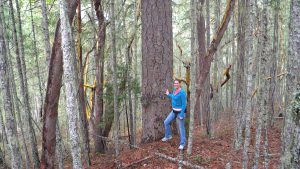
Pine Zone This photo shows an old-growth sugar pine, with invasive Douglas fir, pine, and madrone, in a former savannah near Squaw Flat in 2010. The presence of ponderosa pine and sugar pine, with few understory or directly competitive trees, typified much of the mid-slope (2,400 to 3,800 foot elevation) forest in the study area 200 years ago. The pine zone was typically open and park-like with large — though much younger than present — widely spaced pines; patches of oak, chinquapin, serviceberry, and hazel; scattered stands of Douglas fir; and grassy meadows and berry patches. The average number of 8-inch diameter and larger trees per acre was likely less than 20. The location and age of remnant old-growth trees indicate regular seasonal use of the pine forestlands by Takelmans from lower elevations and southern Molalla from higher elevations. The harvesting of ponderosa pine cambium in the spring and sugar pine, hazel, and chinquapin nuts in the fall may have been times of most intensive occupation of this zone. Hunting for game animals with dogs by Molallans likely occurred on a year-round basis, depending on the daily and seasonal movements of deer, bear, and elk.


Douglas Fir Zone This photo shows an old-growth ponderosa pine and an old-growth Douglas fir, with invasive pine and Douglas fir, on the cusp between the Pine Zone and the Douglas Fir Zone above French Creek, in the Black Rock Fork subbasin in 2010. Although Douglas fir of a wide range of ages was present in almost every type of environment in the study area 200 years ago, it existed in nearly pure stands from 3,800 to 5,000 feet elevation, separating the lower elevation pine stands from the higher elevation subalpine vegetation types. Due to generally steep slopes, isolated location, seasonal snow, and relative lack of food plants, accessible water, and animals, this zone likely experienced the least amount of daily or seasonal use and occupation by people. Although the densest stands of trees in the study area occurred in this zone, they were still often open and park-like with only 20 to 30 trees per acre 200 years ago. Grassy meadows and fern brakes also existed throughout this zone, indicating likely human use and maintenance on a fairly regular basis. Established seasonal ridgeline and streamside trails were used by both game animals and people to reach lower and upper elevations, where food and freshwater were more available. Ridgeline trail networks that crisscrossed this zone were regularly burned to promote grassy meadows, bracken fern, beargrass, serviceberry and other useful food and fiber plants.

Subalpine Zone This photo shows old-growth cedar and an historical cabin at Mud Lake on the perimeter of French Junction prairie in 2010. The highest elevations of the study area (above 5,000 feet) formed an international network of foot trails in precontact time that connected Tribes of the South Umpqua with Indian nations in Rogue River, Klamath Falls, Deschutes River, Willamette Valley, Columbia River, and beyond. This seasonal “travel zone” was covered in snow much of the year, but contained extensive fields of shrubs, forbs, and grasses: huckleberries, manzanita, camas, beargrass, and other berries, fruits, nuts, bulbs, edible roots, fuels, and fibers that were readily available in the summer and early fall. The existence of numerous year-round springs, likely “vision quest” sites, flats, benches, and gently sloping ridgelines add further evidence of intensive year-round and seasonal use; more particularly by southern Molallan hunters, who used dogs and snowshoes to hunt elk and other prized game animals throughout the study area and had ready access to the extensive fields of huckleberries and international trade routes. Other Tribes undoubtedly visited these lands to hunt, harvest or trade for elk hides, huckleberries, and beargrass, and to move trade goods along the landscape. Latgawans and other Takelman speakers from lower elevations likely gathered at Huckleberry Lake, Quartz Mountain, and Pup Prairie areas as well. Klamaths likely moved slaves and other trade goods along the eastern ridgelines, following the Klamath Trail to campgrounds in the Black Rock and French Junction areas, before heading north along Camas Creek into the North Umpqua Basin, or south into the Rogue River basin. It is also possible that Paiutes from the east, southern Molallans from the north, and Kalapuyan-speaking Yoncallans from the northwest also entered this area at these times; also possibly for reasons of hunting, trade, harvesting of favored crops, spirit quests, or simply visiting friends and relatives. Much of this area could be characterized by the ridgeline trails and extensive fields of prized huckleberries, which also contained scattered trees: principally redcedar, Douglas fir, and Shasta red fir.


NEPA Reform: Impacts Outside of the US

Dovetail Partners has published a report suggesting that NEPA ought to be revised to include the environmental impacts of proposed actions beyond the borders of the U.S. The report discusses an example: When timber harvesting declined after the Northwest Forest Plan was implemented, timber production shifted to Canada. As Canada shipped more timber to the US, it shipped less to Asia. Japan, Korea, and Taiwan turned to Russia for timber, where forests are far less productive than in the PNW.

Dovetail’s Jim Bowyer, the author of the report, proposes adding this to NEPA:

“Regarding (i) and (ii) above, any proposed action that would have the effect of significantly reducing or effectively eliminating potential domestic mineral, energy, timber or other critical resource development must be accompanied by a statement regarding likely environmental impacts of the proposed action beyond the geographic area of focus, including outside U.S. borders.”

I suggest that NEPA also should require consideration of impacts with in the US but outside of the region in which the project would be implemented. For example, after the NW Forest Plan, the US Southeast picked up production.

USFS Staffing Shortage

From Politico today:

‘Pretty brutal’: Hiring woes plague Biden effort to contain wildfires

The Forest Service has long struggled with staffing shortages, but the challenges have intensified amid a hyper-competitive labor market and cost-of-living concerns.

The U.S. Forest Service has had chronic staffing shortages for over a decade. But amid rising wages and a fierce competition for labor across the U.S. economy, the agency faces a particularly bleak hiring picture, even as it looks to add an untold number of forest management staff (the Forest Service has declined to estimate just how many people it needs to hire) — to fight wildfires in what could be another tough season, carry out an aggressive new land management plan and continue regular forest management and surveys.

In an email obtained by POLITICO, Forest Service officials are already warning employees in California that there have been 50 percent fewer applications submitted for GS3 through GS9 firefighting positions this year compared to last. And regional Forest Service officials from across the Western fire regions reported struggling with low staffing on a Feb. 15 call with Fire and Aviation Management, the minutes of which were obtained by POLITICO. “Hiring frenzy – lack of candidates, unable to staff 7 days in many places. Continued decline of folks to do the work,” the minutes read, describing comments made by Regional Fire Director Alex Robertson.


Combustion of Aboveground Wood from Live Trees in Megafires

Here’s a new open-access publication by Oregon State’s Mark E. Harmon, with Chad T. Hanson and Dominick A. DellaSala. This is interesting and needed research, but the authors’ focus on carbon emissions from burned trees is only one part of the bigger picture. The write that “if logged and removed for biomass energy, much of this carbon could be released relatively quickly.” True, but that would offset fossil CO2 emissions. Likewise, harvesting and processing into lumber and mass timber products would sequester CO2 for many decades or perhaps longer, also potentially offsetting fossil CO2 emissions from the production of non-renewable building materials, such as concrete and steel. IMHO, Hanson and DellaSala have long campaigned against salvage logging, which seems to be their aim here.

Conclusions

Our field-based examination of the amount of live aboveground woody biomass combusted indicated that while rates for small branch segments can be quite high (i.e., 100%), these rates do not translate in to major losses at the stand or landscape level. This is because high combustion rates in smaller structures are countered by other factors as one proceeds from branches to trees to stands, and to landscapes. The end result in the forests we examined is that even very severe fires combust <2% of live aboveground woody biomass on average. Our work as well as that of others [10] suggests that additional field research is needed to determine how wildfires release carbon to the atmosphere in a wide range of forest structures and fire-weather conditions. We suggest that researchers and policy makers avoid using estimators that are not field-based, because they currently appear to overstate the wildfire emissions used in carbon emissions reporting. As such, they have the potential to misdirect climate mitigation policy. The fact that the vast majority of aboveground woody biomass is not combusted raises the question of when fire-killed trees actually release their carbon. If dead trees are allowed to remain in place, the natural decomposition process could take many decades to centuries to release fire-killed carbon [39]. In contrast, if logged and removed for biomass energy, much of this carbon could be released relatively quickly [40]. Therefore, additional research is also needed to determine the degree that post-fire forest management influences the temporal profile of carbon release.

NEPA Gone Wild

This essay by Ezra Klein in the NY Times is worth a look. (I hope this Share link works — the Times says that, as a subscriber, I can send links to 10 articles per month, and anyone can read the linked articles).

In “Government Is Flailing, in Part Because Liberals Hobbled It,” Klein suggests that NEPA and other environmental laws, are necessary and have been successful, but now make it too easy to block needed projects.

Zoom out from the specifics, though, and look at what it reveals about how government, even in the bluest of blue communities, actually works. Why was it so easy for a few local homeowners to block U.C. Berkeley’s plans, over the opposition of not just the powerful U.C. system but also the mayor of Berkeley and the governor of California? The answer, in this case, was the California Environmental Quality Act — a bill proposed by environmentalists and signed into law in 1970 by Gov. Ronald Reagan that demands rigorous environmental impact reviews for public projects, and that has become an all-purpose weapon for anyone who wants to stymie a new public project or one that requires public approval.

There are laws like this in many states, and there’s a federal version, too — the National Environmental Policy Act. They’re part of a broader set of checks on development that have done a lot of good over the years but are doing a lot of harm now. When they were first designed, these bills were radical reforms to an intolerable status quo. Now they are, too often, powerful allies of an intolerable status quo, rendering government plodding and ineffectual and making it almost impossible to build green infrastructure at the speed we need.

…environmental victories of yesteryear have become the obstacles of this year. Too many of the tactics and strategies and statutes are designed to stop transformational, or even incremental, projects from happening. Modest expansions to affordable housing or bus service are forced to answer for their environmental impact. But the status quo doesn’t have to win any lawsuits or fill out any forms to persist.”

Call for Wildfire Commission Member Applications

FYI, Smokey Wire folks….


Biden-Harris Administration Issues Call for Wildfire Commission Member Applications

Members will recommend prevention and restoration strategies to tackle national wildfire crisis

The Departments of the Interior, Agriculture, and Homeland Security through the Federal Emergency Management Agency (FEMA) are now accepting membership applications for the Wildland Fire Mitigation and Management Commission.

President Biden’s Bipartisan Infrastructure Law authorized establishment of the Wildland Fire Mitigation and Management Commission. Announced in December 2021, it will play a key role in recommending federal policies and strategies to more effectively prevent, mitigate, suppress, and manage wildland fires, including the rehabilitation of affected lands.

The commission is seeking volunteer members from diverse backgrounds, with a specific focus on members who represent non-federal interests, as required by the Bipartisan Infrastructure Law. Members will commit to serve for the life of the commission, which is estimated to be a year and a half, with the first meeting targeted for late spring 2022.

The commission will prepare policy recommendations and submit them to Congress within a year of its first meeting. Members should expect to devote between 10 and 15 hours a month to commission duties, which include attending meetings, strategic planning, and development of the reports. The Departments of the Interior, Agriculture, and Homeland Security through FEMA will provide support and resources to assist members with coordination and facilitation of their duties for the duration of the commission.

Non-federal membership, as required by law, will include state, local, Tribal, territory, and non-government partners with experience in preventing, mitigating, and managing wildland fires and the wildland-urban interface. Preference will be given to applicants from areas of high wildfire risk and areas with a high level of wildland-urban interface.

Applications for membership must be submitted via the online form by 11:59 pm Pacific Time on March 25, 2022. To ensure the process is equitable for all applicants, those who have previously expressed interest in membership must still apply via the online form.

For more information, visit the commission website or email wildlandfirecommission@usda.gov.

In addition to establishing the commission, the Bipartisan Infrastructure Law provides historic funding to address wildfire hazards, including $8.25 billion for a suite of programs aimed at reducing wildfire risks, detecting wildfires, instituting firefighter workforce reforms, and building more resilient infrastructure.

Let’s Discuss: Performance Measure Recommendations from RVCC Report

As usual, the folks at RVCC have come up with a thoughtful and experience-based report, this one called Fighting Fire With Fire.

I was reminded of this section by our discussion around the Pisgah-Nantahala Forest Plan and timber targets.

P O L I C Y O P T I O N S :

PERFORMANCE MEASURES AND BUDGETING
• Immediate action can be taken by elevating the existing “acres mitigated” KPI to a principal target on par with the two existing timber volume and acres treated targets. “Acres mitigated” is a better measure of the comprehensive action needed to reduce fire risk on one footprint acre than the current “acres treated” target. While any annual output target still suffers from the risk of prioritizing the easiest acres for treatment, use of the existing “acres mitigated” KPI would serve as a good bridge to more outcomes-based performance measures.

• Deprioritize the core performance measure of “timber volume sold.” This metric has long guided agency budget allocation and has been used as a benchmark of individual employee career success. While the agency tracks many KPIs, the timber volume target plays a disproportionate role in agency behavior. Addition of new KPIs is insufficient to motivate agency change without also relaxing the timber volume target. Furthermore, the timber volume target should not be conflated with a fire risk reduction outcome.

• Incentivize exceeding fuels reduction targets. So long as annual output targets remain in effect, performance measurement systems – and accompanying budget impacts – should incentivize overperformance, not penalize it. Currently, if a unit exceeds a fuels reduction target, they are expected to perform to the same advanced level in future budget years, essentially disincentivizing innovation and excellence. Performance above target could be rewarded with additional funding.

• The Forest Service should work with the Office of Management and Budget and key external partners to propose new outcomes-based targets that capture the complex, modern
mission of the agency. While outcome measures are more difficult to achieve than simpler annual output targets, there are models for such practices already in existence (see on-the-ground example below).

Here’s the example:

The Colorado Forest Restoration Institute has led participatory mapping to develop fire risk reduction maps that balance multiple values and account for local concerns and knowledge. Such a process could form the core of an outcomes-based performance measure. Agency performance could be evaluated based on annual reports from the agency to local stakeholders demonstrating accomplishments based on priority maps, showing progress towards locally determined goals. Such a performance measure would serve to provide accountability to local stakeholders as well as agency leadership and Congress.

*********************************************

These raise three questions in my mind.

1. What would “deprioritizing” timber targets look like in practice?  Are FS employees more accountable for them than other KPIs?  How accountable are employees in meeting any kinds of targets? Which reminded me of the Mills Accountability Report. I couldn’t find it, but I did find this… in this GAO report from 2003.

Forest Service Has Made Little Progress in Resolving Known Performance Accountability Problems, unlike Other Federal Land Management Agencies.

On another issue, some retirees have questioned how management reviews are conducted nowadays compared to say the BLM.

2. As Jon reminds us, these are national forests,  not locally managed, so the idea of local outcome-based performance measures might not fit with (powerful) groups that support the more nationalized policy view.

3. How could you meaningfully accumulate those measures in a report to Congress? I’m not saying it couldn’t be done, but this seems like the old “consistency vs. decentralization” tension.  Ideas?


$200 million bond issued to ramp up forest restoration in northern Arizona

The title of this post is the title of an article by an Arizona public radio station, KNAU. The link to the bond is a “Sustainability-Linked Bond Framework” that details what the bond entails. I didn’t see information about what would happen if treatment targets are not met.

The company tasked with thinning hundreds of thousands of acres of northern Arizona’s forests has been issued a $200 million bond to ramp up work. It comes as large-scale restoration in the region has moved at a slow pace for nearly a decade.

Goldman Sachs issued the bond to NewLife Forest Restoration. It’s included in what’s known as the U.S. green bond market, and mandates specific targets for thinned acreage every year.

NewLife holds the nation’s largest U.S. Forest Service stewardship contract at 300,000 acres for the Four Forest Restoration Initiative. But the company has struggled to keep up with the pace and scale of the thinning work averaging only about 1,700 acres annually for the last nine years. Under the bond, NewLife’s targets will be 8,000 acres this year, ramping up to 20,000 by 2025, though the company hopes to thin more when it reaches full operation.

NewLife says the funds will help ramp up thinning work by allowing the completion of its facility in Bellemont that opened last year, and increasing capacity at its Lumberjack sawmill near Heber.

4FRI is one of the nation’s largest forest restoration projects and aims to eventually thin 2.4 million acres across the Coconino, Kaibab, Tonto and Apache-Sitgreaves national forests to reduce the risk of catastrophic wildfire.

Forest Service Disaster Relief Funding: Planning vs. Implementation

This note from the American Forest Resource Council‘s February 2022 newsletter may be of interest:

Forest Service Receives Disaster Relief Funding; Timber Outputs Continue to Diminish

The Pacific Northwest Region of the U.S. Forest Service was allocated $291.2 million in disaster relief supplemental funding to be directed to recovery actions associated with wildfires, floods, and other natural disasters. This allocation is a component of the $1.36 billion of supplemental appropriations provided to the Forest Service through the Extending Government Funding and Delivering Emergency Assistance Act of 2021. Most of the funding directed to the Pacific Northwest will be allocated to National Forests in Oregon, specifically those in western Oregon impacted by the 2020 Labor Day fires. The Mt. Hood, Willamette, Umpqua, and Rogue River-Siskiyou National Forests will receive 85% of the $252.9 million directed to Oregon. A complete breakdown of the funding allocation can be found here.

According to a press release on February 16, a portion of the $30.4 million allocated to the Rogue River-Siskiyou National Forest will be directed to the removal of fire-killed trees posing a safety hazard to forest roads caused by the Slater Fire. Similar expenditure of funds is certain for the Mt. Hood, Willamette, and Umpqua National Forests. Each attempted to removed hazard trees by selling them to the local timber industry for manufacturing into wood products; but were met with lawsuits from special interest groups that halted the removal and utilization of those fire-killed trees. Other activities proposed include road resurfacing, culvert replacements, bridge repair, hazardous material/waste removal, and nursery upgrades.

Counter to conventional thinking, this type of funding influx will likely cause the Region’s timber and vegetation management programs to shrink rather than remain stable. For example, as of December 1, 2021, the Willamette National Forest’s assigned timber target was 65 million board feet (MMBF). Less than three months later that target was reduced by nearly 50% to 35 MMBF following the allocation of $78.6 million in disaster relief funding. The cause of this decline is partly of function of reprioritization to address critical disaster relief needs and partly a function of how this supplemental funding can be used.

There are generally two operative sides to every project on U.S. Forest Service land: the planning side (NEPA analysis, wildlife & heritage surveys, timber sale layout, etc.) and the implementation side (completion of the work). Since each side is dependent on the other to achieve project success, each side must be adequately funded in a well-balanced manner. Infusions of supplemental funding, such as the disaster relief fund, have a tendency to disrupt this balance since its allocation is typically limited to the implementation side of the equation and not to the planning side.

For example, the Forest Service may allocate $10 million of supplemental funding to resurface damaged roads. That money will be directed to the material and labor necessary to do the resurfacing. However, none of that money will enable the Forest Service to hire a new engineer to plan and oversee this work, or a new soil scientist to analyze the impacts of the roadwork. The Willamette National Forest recently pointed to engineering gaps as partial cause for the reduction of their timber outputs, as engineers are redirected from timber sale planning to disaster relief planning.

Another scenario that is currently playing out on several National Forests impacted by wildfire is related to their inability to remove and sell fire-killed trees posing a hazard to roads. The Rogue River-Siskiyou National Forest will allocate funding to fell and dispose of those hazard trees, but none of that funding will support the planning and analysis necessary to facilitate such work. Once again, the Forest Service will be compelled to redirect its current staffing resources and by doing so will likely suffer shortfalls in their vegetation management and timber programs.

If the vast majority of supplemental funding continues to be directed solely to the implementation side while the planning side is neglected, we will likely see future renditions of this year’s Willamette National Forest program, only at a much larger scale. This should be a troubling sign for anyone who is interested in seeing the $4 billion from the Infrastructure Investment and Jobs Act directed to forest management result in more acres treated for hazardous fuels reduction or elevated timber outputs. /Andy Geissler