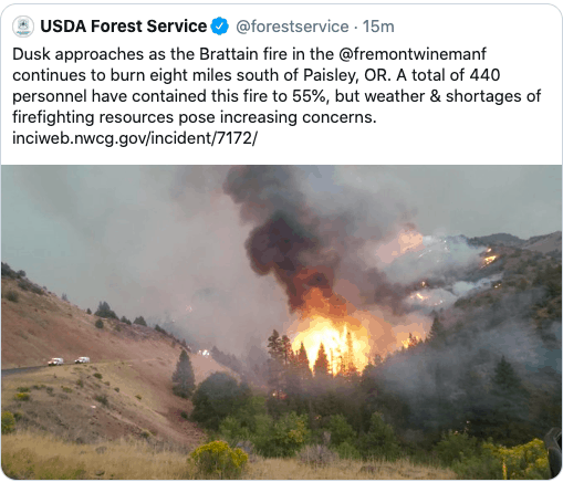
From Smokey Wire member Roy Anderson, posted with his permission:
A week or so ago, I read the article linked below about wildfire in California. In the first few lines it states, “The U.S. Forest Service estimates that dead stands in the Creek fire contain 2,000 tons of fuel per acre”.
2,000 tons of biomass per acre is higher than I’m used to seeing when looking at USFS FIA Data across other parts of the US West….higher by an order of magnitude for average stands. For example, as a rough calculation, assume a stand averages 100 trees per acre and 24” DBH (pretty nice timber!). This would mean that each tree in the stand has about 150 cubic feet of volume (bolewood) or 15,000 cubic feet of bolewood per acre. Each cubic foot of wood weighs about 60 pounds (green weight), which translates into about 450 tons per acre green weight basis (100 trees/acre x 150 cubic feet per tree x 60 pounds per cubic foot divided by 2000 pounds per ton). If you double that amount (which I think is very generous) to account for branches needles and all other vegetation it still only adds up to 900 tons per acre on a green weight basis. An oven dry weight basis would be half of that. It really makes we wonder if the 2,000 tons per acre figure is accurate? If so, maybe its caused by accumulation of fuel from dead timber and other vegetation???
Anyway, I’m writing to see if you have an opinion about the accuracy of this?
USFS press release received today is shown below. The Federal Register notice says little about the proposed regs, except:
The Forest Service’s proposed directive revisions align with the 27 States and DOI’s proposed e-bike rules in adopting a standard definition for an e-bike and a three-tiered classification for e-bikes and align with DOI’s proposed e-bike rules in requiring site-specific decision-making and environmental analysis at the local level to allow e-bike use.
In particular, the proposed revisions would add a paragraph to Forest Service Manual (FSM) 7702 to establish promotion of ebike use on NFS lands as an objective; [emphasis mine]
The proposed rule would direct authorized officers to generally allow, through subsequent decision-making, Class 1, 2, and 3 e-bikes whose motorized features are being used as an assist to human propulsion on roads and trails upon which mechanized, non-motorized use is allowed, where appropriate. The authorization for Class 1, 2, and 3 e-bikes whose motorized features are being used as an assist to human propulsion to be used on roads and trails upon which mechanized, non-motorized use is allowed, would be included in a land-use planning or implementation-level decision. Such decisions would be made in accordance with applicable legal requirements, including compliance with the National Environmental Policy Act (NEPA). Under the proposed rule, where an authorized officer determines that Class 1, 2, and 3 e-bikes should be allowed on roads and trails upon which mechanized, non-motorized use is allowed, such e-bikes would be excluded from the definition of off-road vehicle at 43 CFR 8340.0-5(a) and would not be subject to the regulatory requirements in 43 CFR part 8340. Additionally, e-bikes excluded from the definition of off-road vehicle at 43 CFR 8340.0-5(a) would be afforded all the rights and privileges, and be subject to all of the duties, of a non-motorized bicycle. Under the proposed rule, authorized officers would not allow e-bikes where mechanized, non-motorized bicycles are prohibited.
USDA Forest Service Issues Proposed Guidance to Manage E-Bike Use on National Forests and Grasslands
Washington, Sept. 24, 2020 – The U.S. Department of Agriculture’s (USDA) Forest Service is requesting public input on proposed updates to the agency’s internal directives on how e-bikes are managed on national forests and grasslands. These proposed updates are in alignment with the Secretary of Agriculture’s direction to increase access to national forests and grasslands, and would provide needed guidance for line officers to expand e-bike access while protecting natural resources and other forest uses.
“Serving our customers and honoring our multiple-use mission is at the heart of how we propose to manage e-bike use,” said Forest Service Chief Vicki Christiansen. “Developing consistent, straightforward guidance on this increasingly popular recreational activity will protect resources, promote safety, and increase access to national forests and grasslands for a wider range of users.”
The Forest Service currently manages approximately 159,000 miles of trails across the United States for a variety of recreational uses. An estimated 60,000 miles of those trails – about 38% – are open for e-bike use. Other land management agencies, including the Bureau of Land Management and the National Park Service, also allow for e-bike use on a combined 34,000 miles of trails.
The steady advancement in technology and the continued increase in popularity has led to an uptick in e-bike use on federally-managed land. In response, federal agencies are considering options for expanding access and facilitating their use. The proposed updates to Forest Service directives will generally align with proposed changes at other federal land management agencies.
The proposed directives would categorize e-bikes by class, allowing line officers at the local level to more precisely designate trails for e-bike use in a way that mitigates potential impacts on resources. The proposed directives also include e-bike definitions that are consistent with the Travel Management Rule (36 C.F.R. 212).
Thanks to the LA Times Editorial Board for saying what many environmental groups have been saying for over two decades now. Let’s stop wasting time and money (and blaming wildfires on “environmental terrorists” or “environmental extremists”) and get to work in the Home Ignition Zone with a laser-like focus!
A better way to help Californians survive wildfires: Focus on homes, not trees By THE TIMES EDITORIAL BOARD SEPTEMBER 22, 2020
Firestorms in the West have grown bigger and more destructive in recent years — and harder to escape. Massive and frenzied, they have overtaken people trying to outrun or outdrive them.
Gridlocked mountain roads prevented many Paradise residents from fleeing the Camp fire, which killed 85 people in 2018. This year, more than 30 people have died in the fires in California and Oregon, and again, in many cases, people were trying to escape fast-moving blazes.
There’s much work to be done on how we protect people amid a wildfire, including how and when we advise them to evacuate. But fire experts also are considering different ways to protect communities, and some of these ideas haven’t been given their full due as options for states that increasingly find themselves under siege.
One approach, seen in a bill proposed by Sens. Dianne Feinstein (D-Calif.) and Steve Daines (R-Mont.), is to log more dead trees and dig more firebreaks, among other things. But it’s outmoded and environmentally problematic; environmental groups have attacked the bill for allowing the fast-tracking of logging permits, bypassing the normal review process, in areas far from any towns that could be threatened.
Beyond that, trying to prevent fires can lead to overgrown forests that set the stage for more catastrophic blazes. Rather than going down that road, or cutting trees and brush in order to make fires smaller and slower, the better, more scientifically based approach is to focus more on houses and less on trees.
Some of this is becoming common knowledge. Many Californians have heard the advice to install mesh screens on rooftop vents to prevent embers from getting into attic spaces, and to close off open eaves and the curves under clay tile, where embers can be trapped and smolder. The seminal work of Jack Cohen, a recently retired wildfire expert with the U.S. Forest Service, is finally being recognized: The conditions on and immediately around houses are more important to preserving lives than the conditions of the open brush or forest where the fire is centered.
“Uncontrolled, extreme wildfires are inevitable,” Cohen said.
What’s not inevitable is for houses to have wood decks and siding that give embers a chance to smolder, instead of patios and stucco exteriors. Exterior sprinklers help, too. Feinstein’s bill addresses this, with some help for fire-safe home renovations, but more as an afterthought. Sen. Kamala Harris (D-Calif.) has introduced a bill that targets community protection far more robustly.
Unlike what many people think, ground without plants can be a problem too: dead plant matter under gravel can catch fire, and wood-chip ground cover is even more dangerous. Well-planted green gardens are the best landscape for retarding fires, Cohen said, but that doesn’t have to mean heavy doses of water. Many drought-tolerant native plants are fire resistant and provide habitat for native wildlife — birds, bees and butterflies — as well.
The Escondido-based Chaparral Institute also is trying to get communities to look at smarter ways to save lives during catastrophic fires. Many communities located near vast open spaces such as national forests are rural in nature, with few routes out of town. During evacuations, cars choke the road, with the fire closing in from behind.
That’s why people shouldn’t have to leave town to be protected, the institute says. Other organizations are starting to take a similar view, especially after firefighters and law enforcement in Paradise saved the lives of 150 people by having them shelter in the parking lot of a strip mall. The fire raged around them, but they were safe. The Fire Safety Council of Mendocino County gives similar advice to residents there when evacuating might be risky.
Open, flat spaces within the community, preferably grassy, well-watered ones, could become effective areas for sheltering that might be a mile or two from people’s homes, providing a more realistic solution than expecting entire communities to drive 25 to 50 miles away, or even more. These spaces might include large playgrounds or sports fields at schools. Or cities could embrace the traditional idea of a large village green in the town center that serves as a communal gathering space for much of the year, and an emergency evacuation point during firestorms. Golf courses can perform the same function, and when placed between houses and backcountry, act as a buffer.
Forest management still has a role to play. And the state still needs to prevent residential areas from expanding any further into high-risk fire areas. But communities amid the brush exist throughout the state and must be made safer by following science. Protection from catastrophic wildfire is best done from the inside out rather than the other way around.
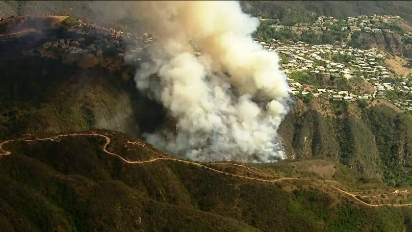
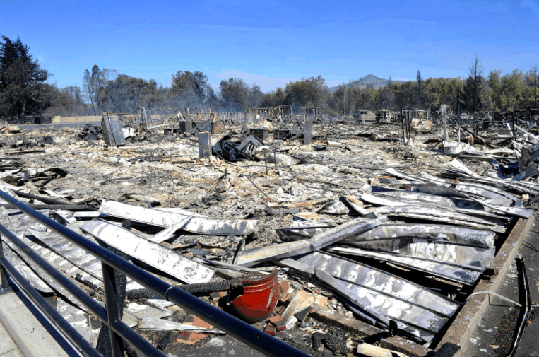
Via the New York Times: The Almeda fire left a path of destruction as it tore through the Rogue Valley in southern Oregon. About 24 hours after it started, an estimated 2,350 homes had been left in ashes. We used satellite images, videos and social media posts to track what happened.
For more information on the urban Almeda fire, and other recent Oregon wildfires, as well as information and resources on how to protect homes and communities from wildfire by focusing on the Home Ignition Zone, see this previous blog post.
The following guest opinion from Dr. James Burchfield appeared in a number of Montana newspapers over the past few days. Dr. Burchfield had a 20 year career with the U.S. Forest Service, including working as a field forester. Later, he served as the Director of the Bolle Center for People and Forests at the University of Montana and after that Dr. Burchfield was the widely respected Dean of the W.A. Franke College of Forestry and Conservation, also at the University of Montana. – mk
Solution to wildfire crisis is not more logging By James Burchfield
It’s time to put to rest the myth that the solution to the West’s wildfire crisis is more logging. Even well-managed forest stands will burn. The primary driver of our expanded, more intense wildfire seasons is climate change. One cannot be simultaneously in favor of healthy, resilient forests while denying climate change.
Higher summer temperatures, less winter snowpack, more frequent droughts, and uncharacteristic, windy storm events are the ingredients of unstoppable wildfires. These characteristics result from human-generated greenhouse gas emissions. Unless we collectively address the root of the problem, other attempts to protect our forests will fail.
This does not mean that forest management has no role to play, for an ongoing treatment of vegetation in the Home Ignition Zone within 100 feet of buildings offers significant protection to residential structures and strategically targeted efforts to reduce fuels so that firefighters can safely contain the course of a fire can work. Yet attempting to “fire-proof” forests is a fool’s errand, since forests have evolved in the presence of fire and sustainable ecological processes depend on fire. We misunderstood fire’s role for much of the 20th century, and through a combination of excessive harvesting of large, fire-resistant trees and heroic attempts to suppress all fires we inadvertently left forests in an unusually vulnerable state to fires.
Thankfully, forest management has become more sensitive to natural processes, and modern treatments have moved away from the heavy hand of clear cuts and tried to recreate the complex mosaics of natural vegetation patterns. But the curve ball of climate change coupled with the expansion of human settlement in dry forest environments has made forest management more challenging than ever. What we don’t need are drastic approaches demanding more logging while foregoing environmental review and analysis.
Science continues to inform us of nuanced impacts of forest interventions. For example, recent research has shown that many forest fuel treatments that focus on thinning do not improve forests’ ability to absorb carbon because they remove so many trees that overall photosynthesis diminishes. However, forest treatments in some forest types that are developed to retain and recruit large trees — sometimes through combinations of harvest and prescribed burning — can over the long term lead to carbon-absorbing, more fire-resilient forests. We can develop these projects through careful, site-specific design, but they are not a panacea.
Unfortunately, all the forest management in the world won’t stop forests from burning at higher levels unless we turn down the heat. We can also help our cause by being responsible landowners and controlling the growth of new human developments in fire prone ecosystems. Yet the real solution depends on shortening the fire season, reducing summer temperatures, and keeping the water cycle intact. This implies a real commitment to climate action, and the recently signed Montana Climate Change Action Plan is a valuable first step. Let’s not be lured into counterproductive schemes that result from our dismay from this difficult fire season. We all need to put our shoulder to the wheel to reduce our carbon footprint and tackle climate change. Our forests depend on it.
Before retiring, James Burchfield worked as a field forester for the Forest Service and served as Dean of the W.A. Franke College of Forestry and Conservation at the University of Montana.
[NOTE: I wrote the following post on this blog on October 23, 2019 highlighting new research by a U.S. Department of Agriculture Forest Service scientist and University of Wisconsin-Madison partners. I’m reposting it 11 months later because it seems relevant to many of the recent discussions on the blog.]
This morning I got an email from U.S. Forest Service Research News, which including a link to this new research from the USFS and partners concerning wildfires in California.
While the research may be surprising to some, it’s not at all surprising to many of us who have said the same thing going back a few decades now. We’ve had perhaps over a hundred debates about this on the blog over the years. Heck, Dr. Jack Cohen’s research documented much of this going back into the 1980s, if not even earlier. Richard Halsey and his California Chaparral Institute have been also talking about these issues for at least 20 years. And those of us who’ve been branded as “environmental terrorist groups” – and blamed for California wildfires by the likes of former Interior Secretary Ryan Zinke – have been also trying to get the public and policy makers to understand the dynamics at play for decades as well.
Remember, it’s been very common for politicians from through the country (but especially the West) to use wildfires in California as the reason why we need to dramatically increase logging on our public lands by systematically weakening bedrock environmental laws. While that may make for good politics when people turn on their TV’s and see flames, it doesn’t make for good policy that will protect communities, firefighters and save lives and money.
Most California Fires Occur in Area of Wildland-urban Interface with Less Fuel and More People
Madison, WI, September 24, 2019 – In California, the state with more building destruction by wildfire than all of the other states combined, new research by a U.S. Department of Agriculture Forest Service scientist and University of Wisconsin-Madison partners found something surprising. Over nearly three decades, half of all buildings destroyed by wildfire in California were located in an area that is described as having less of the grasses, bushes and trees that are thought to fuel fire in the wildland-urban interface, or WUI.
The study by H. Anu Kramer with Forest Service scientist Miranda Mockrin and colleagues, “High wildfire damage in interface communities in California,” notes that a portion of the WUI defined as “interface” and characterized by having more homes but relatively little wildland vegetation experienced half of the building losses due to wildfire but composed only 2 percent of the total area burned by the wildfires assessed in the study. The study was recently published in the International Journal of Wildland Fire and is available at: https://www.nrs.fs.fed.us/pubs/58348
California’s expansion of housing within and adjacent to wildland vegetation is not unique; the most recent assessment shows that the WUI now includes about one-third of homes in the United States. As wildfire management has become more complex, costly and dangerous, defining what constitutes WUI and defining more specific types of WUI has become more important as local communities strive to apply resources and policy-decisions where they will be most effective in saving lives and property.
The Federal definition of WUI describes two specific areas: “interface” WUI includes developed areas that have sparse or no wildland vegetation, but are within close proximity of a large patch of wildland. “Intermix” WUI, on the other hand, is defined as the area where houses and wildland vegetation directly intermingle. Both are separate from “rural” areas, which may be characterized by agricultural land and low-density housing and development (less than 1 house per 40 acres).
“Our findings show that WUI areas do experience the vast majority of all losses, with 82 percent of all buildings destroyed due to wildfire located in the WUI,” Mockrin said. “We were surprised to find 50 percent of all buildings lost to fire being destroyed in the interface portion of the WUI, however. Many risk reduction plans focus on natural vegetation fueling fire, but in the interface WUI where so much of the destruction is occurring, we have to consider finer-grained fuels such as wood piles, propane tanks, and cars.”
Study findings suggest that wildfires are still rare in urban areas. The Tubbs fire that struck Santa Rosa, Calif., in 2017 was similar to other California wildfires in that the majority of buildings lost in the fire were located in the WUI; however, the Tubbs Fire was unique in having 25 percent of all destruction occurring in urban areas. In comparison, 4 percent of destruction occurred within urban areas in other California fires. Other recent and highly destructive fires, including the 2018 Carr, Camp and Woolsey fires, included no urban area within their perimeters, exemplifying the rarity of the Tubbs’ building destruction in urban areas.
“Although the Tubbs fire was not the norm, it seems like every fall there is a new record-setting fire in California, with three of the five most destructive fires in state history having burned in the last 5 years and the deadliest California fire (the Camp fire) burning last year,” Kramer said. “These fires are fueled by the homes themselves, landscaping, and other man-made fuels that are seldom included in the fire models that are used to predict these fires. Our work highlights the importance of studying and mitigating the fuels in these interface WUI areas in California where most of the destruction is occurring.”
In addition to solidifying definitions of interface and intermix WUI so communities can address their different attributes in wildland fire planning, researchers suggest that fire behavior models should be revisited.
The study was co-authored by Volker Radeloff of the University of Wisconsin-Madison and Patricia Alexandre of the University of Lisbon.
This post isn’t meant to serve as a be-all and end-all piece about all wildfires in general. Rather, it’s more specifically about the current Oregon wildfires burning in clearcut, heavily logged, and roaded areas of the Oregon Cascades. While these images and videos certainly don’t tell the entire story, they do tell part of the story—and a very important part of the story, I’d argue. I plan on adding to this post as time permits, so please keep that in mind.
As many of us know, different ecosystems burn differently. High severity fires are natural, normal and expected in some ecosystems, not so much in others. It’s important to remember that many of the largest and most destructive wildfires in recent years—in terms of human lives and structures lost—were not even “forest” fires at all, but rather more urban fires that raced through neighborhoods and communities surrounded by dry grass, brush, shrubs, and chaparral. Many of these fires also had little to do with federal public lands. However, all of these deadly fires have been pushed by heavy winds during a period of prolonged drought and record high temperatures.
The horrific Almeda fire, which started on September 8 during very high winds and blasted through Talent and Phoenix, Oregon, burning down 2,357 residential structures, had zero to do with forests and public lands, for example. Here’s what a Talent, Oregon evacuee, and scientist, Dr. Dominick DellaSala, wrote in the aftermath of that tragic wildfire.
The wildfires highlighted below all burned primarily within “stand-replacing fire regimes,” which means they are forests that typically—and naturally—experience infrequent, but severe fires. When fires in “stand-replacing fire regimes” take off and expand exponentially, they are always weather-driven—fierce winds, high temperatures and very low humidity. Let’s take a look at some of the landscapes that have burned in the Oregon Cascades since Labor Day weekend.
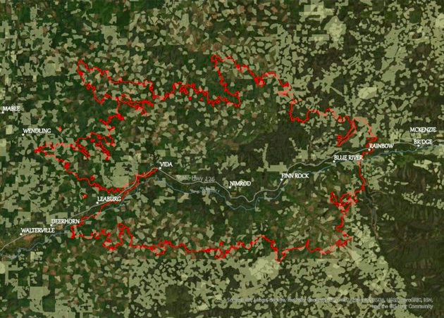
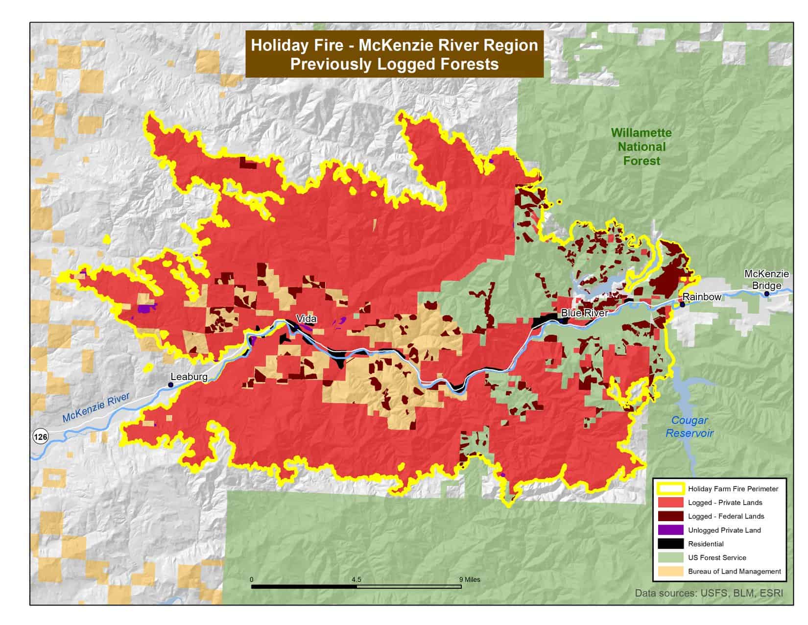
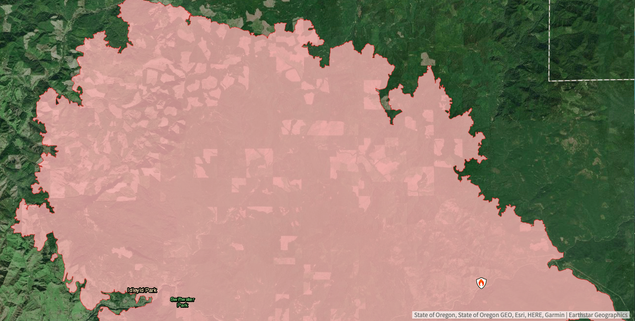
The image above is of the 170,000 acre Holiday Farm Fire, which started on the evening of September 7 during raging winds. I got the image from Firefighters United for Safety, Ethics & Ecology. The current fire perimeter is in red and as you can clearly see the fire has burned through an extremely heavily clearcut and logged part of the Oregon Cascades.
While the cause of this wildfire is currently under investigation, the Oregonian reported on September 17 that “residents told the Oregonian/OregonLive that the blaze was preceded by a power outage, a loud explosion and a shower of blue sparks from an electric line near milepost 47 on Oregon 126 – the exact location where state officials have pinpointed the start of the fire.”
According to Oregon Wild “A whopping 76% of the Holiday Farm Fire area was previously logged” (See: shades of red on the map below).
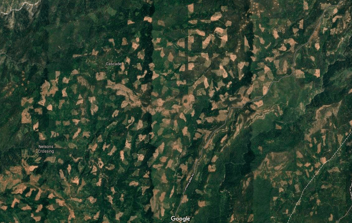
Speaking of the southwest part of the Holiday Farm Fire. Kevin Matthews flew over what is now the south edge of this fire on July 24, six weeks before the wildfire. Matthews is a former Lane County Commissioner candidate. Below is his video.
Moving further south, above is an image of the Archie Creek Fire burning northeast of Roseburg.
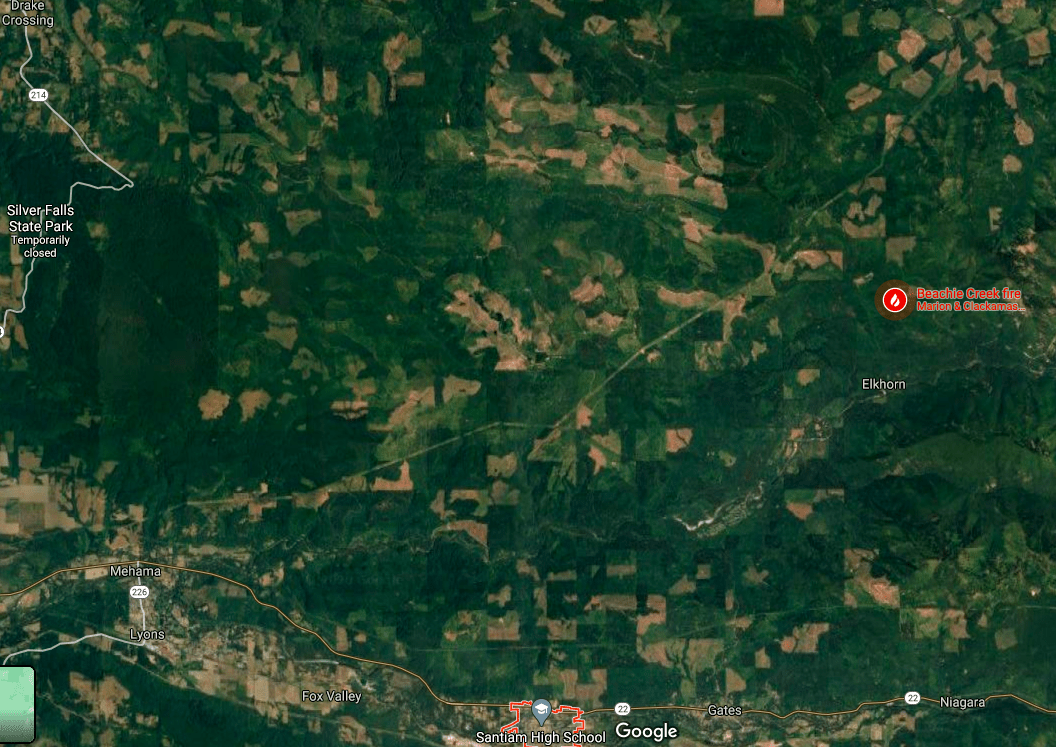
Above is an image of the Beachie Creek Fire directly north of Mill City. Fire officials confirmed that at least 13 of the fires that fed this blaze during the high wind event on Monday were caused directly by downed power lines. These fires spread very quickly fanned by what is essentially the Oregon Cascade’s equivalent of the So Cal’s Santa Ana winds or the Bay area’s Diablo winds, all of which have caused considerable damage and huge wildfire runs.
Directly above is the same general image of the Beachie Creek Fire area north of Mill City, but without the wildfire overlay so you can more clearly see how heavily logged and roaded this area is. The rest of the country may not realize it, but the Santiam River watershed and the McKenzie River watershed where the Holiday Farm Fire ripped through, as some of the most heavily logged landscapes in Oregon, which is one of the most heavily logged states in the country.
UPDATE 10/1/2020: A class action lawsuit filed against Pacific Power alleges the utility’s failure to shut down its power lines amid a historically dangerous storm caused wildfires that devastated the Santiam Canyon on Labor Day evening.
“Despite being warned of extremely critical fire conditions, Defendants left their powerlines energized,” the lawsuit says. “Defendants’ energized powerlines ignited massive, deadly and destructive fires that raced down the canyons, igniting and destroying homes, businesses and schools. These fires burned over hundreds of thousands of acres, destroyed thousands of structures, killed people and upended countless lives.” Read the full story here.
All of the wildfires highlighted above, including the Riverside Fire, burned within “stand-replacing fire regimes” within the west (i.e. “wet”) side of the Cascades. These are NOT “open, parklike stands of ponderosa pine” that may have historically burned more frequently and generally at low to moderate severity (and even at high severity when conditions were right (like maybe during a megadrought, record high temps and heavy winds…sound familiar?).
What does current science say about the forests within these “stand-replacing fire regimes” and potential “management options?” Here’s a 2018 “Innovative Viewpoint” by some of the top minds in the country on this topic:
ABSTRACT: Building resilience to natural disturbances is a key to managing forests for adaptation to climate change. To date, most climate adaptation guidance has focused on recommendations for frequent‐fire forests, leaving few published guidelines for forests that naturally experience infrequent, stand‐replacing wildfires. Because most such forests are inherently resilient to stand‐replacing disturbances, and burn severity mosaics are largely indifferent to manipulations of stand structure (i.e., weather‐driven, rather than fuel‐driven fire regimes), we posit that pre‐fire climate adaptation options are generally fewer in these regimes relative to others. Outside of areas of high human value, stand‐scale fuel treatments commonly emphasized for other forest types would undermine many of the functions, ecosystem services, and other values for which these forests are known. For stand‐replacing disturbance regimes, we propose that (1) managed wildfire use (e.g., allowing natural fires to burn under moderate conditions) can be a useful strategy as in other forest types, but likely confers fewer benefits to long‐term forest resilience and climate adaptation, while carrying greater socio‐ecological risks; (2) reasoned fire exclusion (i.e., the suppression component of a managed wildfire program) can be an appropriate strategy to maintain certain ecosystem conditions and services in the face of change, being more ecologically justifiable in long‐interval fire regimes and producing fewer of the negative consequences than in frequent‐fire regimes; (3) low‐risk pre‐disturbance adaptation options are few, but the most promising approaches emphasize fundamental conservation biology principles to create a safe operating space for the system to respond to change (e.g., maintaining heterogeneity across scales and minimizing stressors); and (4) post‐disturbance conditions are the primary opportunity to implement adaptation strategies (such as protecting live tree legacies and testing new regeneration methods), providing crucial learning opportunities. This approach will provide greater context and understanding of these systems for ecologists and resource managers, stimulate future development of adaptation strategies, and illustrate why public expectations for climate adaptation in these forests will differ from those for frequent‐fire forests.
For those who aren’t familiar, “forests with stand‐replacing fire regimes” include many forests in the West Cascades region of Oregon and Washington, much of the Coast Range of Oregon and Washington, much of forested landscape within the Northern and Central Rockies, as well as the Southern Sierras, especially forests found at upper elevations in these regions.
Next, let’s move way out of the forests and into the Home Ignition Zone (HIZ). According to the National Fire Protection Association, “The concept of the Home Ignition Zone was developed by USDA Forest Service fire scientist Dr. Jack Cohen in the late 1990s, following some breakthrough experimental research into how homes ignite due to the effects of radiant heat.” The HIZ is divided into three zones. 1) Immediate zone: The home and the area 0-5’ from the furthest attached exterior point of the home; defined as a non-combustible area; 2) Intermediate zone: 5-30’ from the furthest exterior point of the home; and 3) Extended zone: 30-100 feet, out to 200 feet.
For over two decades, the forest protection community and forest activists have been imploring people to follow Dr. Jack Cohen’s research and heed his advice on how to protect homes and communities from wildfires. I’ve spoken with Dr. Cohen numerous times about his research, as he was based here in Missoula. We’ve invited him to speak at numerous public presentations and panels. I’ve worked with him and recorded his power-point presentation for community access TV channels and we’ve mailed about 100 of his of videos to libraries across the American West for free check-out. In 2003, I produced a newspaper primer featuring Dr. Cohen’s research and recommendations and paid to have them inserted in over 500,000 papers in rural communities across the West. Countless other forest protection groups and activists also educated the public about effective Home Ignition Zone defense measures over the past 20 years.
Meanwhile, for over two decades, pro-timber industry politicians have largely exclusively called for more public lands logging with less environmental oversight, less scientific analysis, fewer protections for wildfire, and no real focus on immediately around homes. Coincidently, most all of these same pro-timber industry politicians are also pro-oil and gas and pro-coal politicians. I can think of few examples of these pro-timber industry politicians, or timber mill owners and logging industry lobbyist for that matter, sharing the research of recommendations of Dr. Jack Cohen with members of the public.
However, I can think of lots of examples of these same pro-timber industry politicians blaming wildfires this year—and in every recent year I can remember since the mid-1990s—on “environmental terrorist groups,” “environmental radicals,” “fringe groups,” and “environmental extremists.”
Of course, this is not to say that there are not some good people in the “timber industry” that get it. One such person is my friend Mark Vander Meer of Bad Goat Forest Products in Missoula, someone I literally can’t say enough good things about. Not only is Mark a logger, but he’s a certified soils scientists who also runs a successful watershed consulting business. We’ve partnered with Mark and his team a number of times over the years to do bona-fide forest restoration and watershed work. For a couple of years, I raised funds to hire Mark’s crew and we all teamed up with the West End Volunteer Fire Department to create defensible space on private land around the DeBorgia, MT community through education, action, and fellowship. We followed Dr. Cohen’s Home Ignition Zone principles and focused our work around the homes of folks who were elderly or couldn’t do, or pay for, the work themselves. Here are some scenes from that work in 2006 and again in 2007. Mark is the guy in the photos who might be able to moonlight as Santa Claus at your local department store this winter.
“The question I hear over and over is did bad forest management cause the Labor Day fires? In a word: no. The data shows that a combination of strong east winds and extremely low humidity are what caused these fires. Plain and simple. 30-40 mph winds from the east blew for over 24 hours, bringing record low humidity in the single digits to the region….Short of scraping the land bare, there is no type of forest management that could have stopped these fires. Having a discussion about the type of forest management that we as Oregonians want on both our public and private forestlands is important. Good forest management can indeed help to slow less severe fires and reduce the loss from a fire when it does burn. But those conversations are moot in this particular context.”
Again, the information presented here certainly doesn’t tell the entire story, but it does tell a part of the story. Just a reminder that I will be adding to this post as time permits.
BLOGGERS BONUS: Below is a pre-fire image of the landscape where part of the 280,000 acre North Complex Fire in California has burned this year. Yes, I know this isn’t in the Oregon Cascades. By acres, it’s the 6th largest fire in state history. Maybe Trump is right and America does have a “forest management problem.” [Note: These are clearcuts…miles and miles and miles of clearcuts]
The Cheryl Lane Apartments were among many homes and businesses leveled along Hwy 99 in Phoenix on Tuesday. Photo by Jamie Lusch / Mail Tribune.
The following piece was written by Dr. Dominick DellaSala, chief scientist at Wild-Heritage, a project of the Earth Island Institute, and award-winning author of over 200 peer reviewed studies and books. It was published yesterday in the Medford Mail Tribune. To view more photos from the Almeda fire in the Talent and Phoenix, Oregon area taken by the Mail Tribune’s Jamie Lusch, click here. – mk
As I write this, my hometown of Talent is a disaster area, and I am in tears over the destruction of my neighborhood. Lives have been forever changed by this tragedy that could have been avoided with better planning.
Our elected officials have neglected to take action on community safety, focusing mostly on backcountry logging projects, and this destruction took place on their watch.
We simply were not prepared.
Consider, it took hours to reach safety in miles-long traffic jams. Ashland has a single lane leaving town heading north to Interstate 5, jammed with escaping traffic. As grateful as I am for our brave emergency responders, they were understandably overwhelmed and grossly underfunded.
We have been falsely promised that if only forest managers can thin, smoke levels would drop and wildfires would be less intense.
The Almeda fire had nothing to do with forests. Hundreds of urban structures burned in a domino effect ignited by embers cast for miles ahead of flames by unusually strong winds, extreme temperatures and excessive drought as homes became fuels.
Wildfire activity follows drought cycles and global-regional temperature spikes that dictate local fire weather. The Pacific Coast has been in excessive drought since March, aided by unprecedented summer temperatures, historically low humidity levels, and strong winds that scientists have been warning us about at least since the tragic Paradise-Camp fire disaster.
Consider that in 2017, 1,300 wildfires in the interior of British Columbia spread rapidly during extreme summer heat. Aided by strong winds, smoke billowed into the southeasterly flow of the jet stream, eventually settling in the valley. This year, fires from as far away as treeless Siberia again poured smoke into our region as, for the first time in recorded history, Siberia experienced triple-digit temperatures. Wildfires in California recently broke out during an unprecedented heat wave with temperatures soaring past 120 degrees, spinning off rare pyro-tornadoes and sending smoke into nearby states. Escaped campfires, accidental sparks and “gender-reveal” parties contributed.
Meanwhile, the climate of Oregon becomes increasingly like that of Redding, greatly upping the ante that such extreme conditions will become the new “abnormal,” as is the case for much of the dry West.
Instead of prayers and thoughts from elected officials, we need real action that rebuilds communities with safety first and foremost. We desperately need an infusion of disaster aid, relocation assistance, and proper planning to make sure this never happens again. This means planning for home hardening and defensible space along with sufficient shelters for every single community. Local planners need to have escape routes ready to go on a moment’s notice with a central warning system accessible to all residents in real time.
Retraining timber managers in law enforcement to monitor recreation use in extreme fire weather would prevent future unwanted fire ignitions. Nationwide, some 80% of all fires are human-caused, about half of them in our region by people. Road and campground closures are a must in red-flag warnings, no matter how unpopular.
Logging will do nothing to help us out of this mess. Based on the most comprehensive study ever conducted of 1,500 forest fires across the West, forests with the most logging burned in the severest fires [PDF links here and here]. This was also shown for a large fire near Roseburg in 2013 that raced through densely packed tree plantations under extreme fire weather (high temperatures and wind gusts). So, instead of logging forests, they should be managed to contribute to climate safety.
Climate-safe forest management means protecting older forests on public lands from logging to absorb and store atmospheric carbon while allowing logged-over areas decades to recover. For instance, the landmark Northwest Forest Plan reversed the dangerous trend of global warming pollution from excessive logging in the 1980s to public forests now acting as vast repositories of carbon. Logging, mostly on private lands, emits up to 10 times more carbon than even the largest wildfires.
By most accounts, scientists give us but a decade to greatly cut global warming pollution before all hell breaks loose. The way we manage forests and urban areas right now will affect generations to come as carbon has a long hang-time in the atmosphere — decades to a century.
As an evacuee, it’s only natural for me to feel angry about the abject neglect for public safety that could have been avoided with proper planning by elected officials in a region that is feeling unprecedented pain. It is irresponsible for our state and local elected officials to continue ignoring the obvious connection to climate chaos going forward.
Dominick A. DellaSala, Ph.D., is now chief scientist at Wild-Heritage, a project of the Earth Island Institute, and award-winning author of over 200 peer reviewed studies and books.
The following comment was posted by Jim Furnish, former Deputy Chief of the U.S. Forest Service on this blog over here. I believe Jim’s “2 cents worth” deserves to have its own post for discussion.
According to Jim’s bio at the Oregon State University Press: “Jim Furnish is a consulting forester in the Washington D.C. area following a 34-year career with the USDA Forest Service. He served as the agency’s Deputy Chief and Siuslaw National Forest Supervisor in Corvallis, Oregon. Furnish was a principle Forest Service leader in creating the Roadless Area Conservation Rule (2001), as well as in reforming management of the Siuslaw National Forest from timber production to restoration principles. He has served on the board of directors of several environmental and faith-based non-profit organizations.” More details on Jim’s book, “Toward A Natural Forest: The Forest Service in Transition (A Memoir)” can be found here.
My 2c worth, after almost 40 years with USFS 1965-2002, and a couple more decades observing since… As any on-the-ground firefighter or fire boss will tell you, when a fire gets ripping with high wind, heat, and low humidity and reaches project size, suppression efforts are band aids, at best. And we are seeing it RIGHT NOW. Control will come with – and ONLY with – a change in the weather. It’s an ugly scene and an ugly truth. But the “wet West” of 1945-1980, coinciding with a huge uptick in logging, population, and residential development, kind of lulled us into a false mindset (of which I was also guilty). Now that drier conditions have become entrenched, exacerbated by climate change, we reap the whirlwind. I approve of veg mgmt to try to reduce fire risk and severity, but have seen my share of fires burn right through treated areas. I strongly endorse focusing on WUI first and investing in fire-wise treatments of forest homes and lots. But when too-close homes start to burn and the domino effect kicks in, best to stand back and take your medicine. Sorry to be such a downer, but all the talk of logging impacts on fire behavior (and there ARE impacts) is akin to arguing about how the clothing I wear affects my weight on the scale vs. weighing naked.

 The following comment was posted by Jim Furnish, former Deputy Chief of the U.S. Forest Service on this blog