Putting Your Dot on the Map

They are “remembered landscapes.”

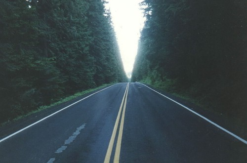
Nearly every weekend when I was growing up, my parents, my two sisters, our large family dog, and I would get in the car and head to my grandparents’ house in St. Maries, Idaho.  The trip was usually pretty boring for a kid, but we always got excited when we got to the White Pine Scenic Drive in the St. Joe National Forest.  The highway carved through the forest creating a tunnel effect, and in the middle was a sign along the highway that said “cool spring.”  Even the dog somehow knew when we were getting close to cool spring.  We’d stop, get a drink, walk into the woods a bit, and marvel at the dense trees with moss growing everywhere.  Down the road was the tallest white pine tree in the world, but that was just a boring statistic to a kid.   The statistics didn’t matter, but the place was special.

Today the sign is gone, cool spring is gone, and the trail has been expanded for motorized use.  White pine is incredibly susceptible to blister rust and many trees have died.  The large tree has fallen over.  My dad and my niece got their picture taken by the incredibly huge roots.  It doesn’t matter that the forest has changed, but the place will always be special.

When I was working in the Black Hills, I once talked to a county commissioner on the Wyoming side.  She told me that when she was growing up, her dad loaded up the Studebaker and headed up a road that isn’t even recognized as a road today.  They would reach a large meadow and have a picnic lunch.  Today, that meadow is overgrown with dense small trees, and probably needs to be thinned.  The place is special, but her experience is gone.

In Colorado, Monarch Pass feels like it’s on top of the world.  From the top, you can see an expanse of trees that seems to go forever.  For folks that have traveled on U.S. 50 from the east, this is their continental divide experience.

In the San Juan Mountains of Southwest Colorado, you can go on a hike from the desert to a meadow with a stream running through it, and look up at snow capped peaks as high as you can imagine.  It’s unreal that you can see desert and tundra at the same time.

Social scientists often group participants in a forest planning process as members of a “community of place” or “community of interest.”  I don’t have a direct economic or social stake in how forests in Idaho are managed.  I don’t even live in Idaho any more, but I am still connected to a “place” in a forest along a 12-mile stretch of highway.

Before 1976, the Forest Service conducted “unit planning” with units roughly the size of ranger districts.  In part to increase the working circle of potential timber harvest to assure a continuous supply, NFMA established Forest Plans.  But Forests often were too big for the community of place.  Then, the scale of planning grew even bigger.  The St. Joe and White Pine Drive were administratively split between the Clearwater and the new monolithic Idaho Panhandle National Forests.   The area around cool spring fell on the Clearwater side.  The old Forest Plan put White Pine Drive in a scenic corridor management area, but the area was too small to show on the forest plan map.  The Clearwater has now combined with the Nez Perce to complete one large planning effort.

The area in the Black Hills fell into an inventoried roadless area subject to the 2000 roadless rule.  Monarch Pass was designated in the Westwide Energy Corridor EIS as an important corridor.  The multi-state decision doesn’t mention how the corridor entirely covers the Monarch Pass Ski Area.

Forest planners have discovered that place matters.  The Medicine Bow-Routt-Thunder Basin has done three plans.  The Pike-San Isabel-Cimarron-Comanche will do two.  There are some excellent examples of place-based planning in the Beaverhead-Deerlodge, Chugach, and GMUG forest planning processes, where forests are subdivided into “places” for planning.  These were discussed in a 2003 workshop in Portland.    The authors note:

“Place-based planning” refers to land and natural resource planning efforts that bring together diverse human values, uses, experiences, and activities tied to specific geographic locations. Although planning efforts have always focused on specific places through land use zoning frameworks, place-based planning is different from other types of approaches. For example, whereas land use zoning segregates dominant uses from one another on the landscape, place-based planning takes a more holistic approach, focusing on identifying current uses, values, and meanings. In addition, place-based approaches tend to take a longitudinal perspective, exploring desired future conditions for the landscape. This approach enables participants to identify a variety of uses that might occur concurrently rather than designating one primary use for the upcoming 10 to 20 years.

Some commentators are concerned that place-based planning and the new emphasis on collaboration are putting National groups at a disadvantage.  Ohio University political science professor Nancy Manring wrote a paper in 2004 about the 2005 planning rule provision that replaced the appeals process with an objection process.   She observed:

McCloskey (2000), Coggins (2001), Foster (2002), Hibbard and Madsen (2003) and Kenney (2000) all have argued that collaboratives may maximize community-based interests at the expense of national stakeholders and values. As Weber (1999, p. 482) cautioned, “The danger is that such communities will develop a sense of themselves apart from and to the detriment of the nation.” No doubt, it will be easier for communities to develop a separate sense of themselves if representatives of national interests and values are not physically present at the negotiating table. The potential tensions between local and national values – between the communities of place and the communities of interest – are thrown into sharp relief by the realities of collaborative planning without the traditional appeals process as a safeguard. “

At the beginning of the planning process for the San Juan Forest Plan Revision, participants at public meetings were given sticky dots to place on a map.  There was even a parallel process on the web, where you could put a computerized dot on the map.  The idea was that participants could identify their special places, and where resource conflicts might occur.  These sticky dots were used in drawing the the forest plan map.  The Plan will use geographic areas as big as ranger districts, and within the areas, there are subdivisions displayed by using eight development “themes.”  A final Plan is expected next year.

Project-based Forest Planning and Collaboration

People collaborate best when they are in the woods talking about real forests and what to do with them.  On the other hand, put them in a conference room to debate the merits of hypothetical silvicultural standards and you end up with the sort of nonsense we are seeing in northern Arizona. There several prominent, litigious environmental groups have made peace with local timber mills and workers regarding which trees to log on several national forests.  The Forest Service, however, doesn’t want to play ball.  Instead, its regional staff in Albuquerque is busily re-writing northern Arizona NFMA plans to include silvicultural standards that are inimical to agreements reached in the woods between the green groups and industry.

This bureaucratic passion play could be avoided altogether if NFMA plans were based on projects, not standards.  Recall that NFMA requires only one thing of forest plans:  “the planned timber sale program and the proportion of probable methods of timber harvest within the unit necessary to fulfill the plan.”  Recall also that NFMA does not mandate one forest plan for each national forest.  The Forest Service has broad discretion to decide the geographic scope of each plan, i.e., a single national forest can be divided into several NFMA plans.

Under the current two-tier planning regime, the Forest Service and its protagonists get to fight twice over what to do with national forests.  The forest plan fight is all about the adequacy of standards, the aspirational zoning of land, and the magnitude of largely irrelevant allowable sale quantities.  The second fight, at the project level, often repeats all of the above (because forest plan standards become ripe for legal challenge only when implemented in a project), with plan-consistency arguments thrown in for good measure.

Let’s just cut out the middle man altogether.  A forest plan should be no more than the logging projects the Forest Service proposes for the next several years.  The plan’s NEPA document (probably an EIS, but an EA is not inconceivable if the logging projects are environmentally modest) would evaluate alternatives, disclose effects, and form the basis for any required inter-agency consultation.  The plan’s Record of Decision would set forth the site-specific projects to be undertaken,  eliminating separate project-based planning and decision-making.  Forest planning collaboration, if pursued, would consist of people talking in the woods about each of the projects.

Forest Planning and Oil and Gas Leases

Forest planning got a lot more complicated in March 1990 when the Forest Service issued regulations at 36 CFR 228.102 in accordance with the 1987 Federal Onshore Oil and Gas Leasing Reform Act, and recommendations by a National Academy of Sciences group chartered by the Act.  Under these regulations, there are six steps to leasing, and Forest Plans in the 1990s and 2000s addressed the first step, sometimes the second step, and sometimes even a preliminary finding related to the third step:

Step 1: The Forest Service identifies what lands may be available for leasing.

Step 2: The Forest Service authorizes BLM to conduct leasing on specifically identified lands and under certain stipulations (in some cases no surface occupancy, controlled surface use, or timing restrictions).  The Forest Service leasing analysis can range from forest-wide to a smaller specifically defined area, with specific binding requirements to each 40-acre area.

Step 3: After parcels have been identified for leasing, the Forest Service verifies that potential effects have been adequately considered, and that leasing is consistent with the Forest Plan.

Step 4:  BLM does an assessment, and determines if there are any additional stipulations for a parcel.

Step 5: BLM conducts a sale.

Step 6: BLM issues the lease and begins the permitting process.  The lessee must fill out an “application for a permit to drill” (APD) that includes a Surface Use Plan of Operations (SUPO).  The Forest Service approves the SUPO after an evaluation of environmental consequences and stipulation consistency.

It’s been challenging for planners to decide how many of these steps to link with the forest planning decision.  However, only the first step is truly consistent with the current idea of a broad, strategic forest plan.  In dedication to efficiency and economy, many decision-makers may naturally conclude that combining the first two steps is more efficient and economical than keeping the decisions and their supporting analysis processes separate.  However, in a number of cases to date, imbedding oil and gas leasing decisions in forest plan revisions has been neither efficient nor economical.  In fact, combining the first two steps in a single decision-making process has led to significant delays and increased costs, has been unwieldy to manage, and has confused the public.  Since the emphasis on forest planning is being “strategic”, it’s difficult to combine the more detailed analysis and prescriptive oil and gas decision-making.

This has been especially difficult because a leasing analysis requires a “reasonably foreseeable development” (RFD) scenario report.  This report provides a quantitative (if possible) description of oil and gas occurrence and development potential, along with well projections, and specific information about probable characteristics of wells and productions.   This report can quickly become dated, and the longer a planning process, the greater the risk of inaccurate information.

If we want to streamline planning, it may be better to make the oil and gas leasing decision as a “program” decision outside of forest planning, much like specific road by road travel management decisions are made outside of forest planning.

What Have We Learned Since the COS Report?

Thanks to the generosity of the Society of American Foresters, we can post articles from the Journal of Forestry May 99 edition on this blog. This edition of the journal focused on the COS Report. Today I’ll post the Norm Johnson article here.

Since 1999, we have tried many of the ideas that the COS brought forward. I would be interested in how you all think these ideas have worked.

I will post later this week on my experience with trying out some of these concepts.

The Frame Game

There is power in “framing” political discourse and policy development: Those who control the frame, control the content, the context, and more. In short, “He Who Sets the Frame Controls the Game”.

What just happened in the NFMA Rule Development game? The comment period closed yesterday. The frame was set by rehashing experience in planning, then constructing five “Substantive Principles for a New Rule” and three “Process Principles” (each with a battery of related questions). How many people, do you suppose, chose to respond outside that frame? How powerful was the frame?

In my formal comment I said that I wish the Forest Service had simply established a blog, and begun with a simple question, like: “Given the noble ideas embedded in RPA/NFMA (Wikipedia link) and other principal laws related to the Forest Service, how might the planning/management process of the USDA Forest Service be improved?” Then I said that I hoped someday the FS would indeed engage the public in meaningful inquiry as to its operations and the management of the national forests. Not yet, though. I added:

Unfortunately but not unexpectedly given the RPA context, these regulations have been dubbed a “planning rule.” If one looks at RPA/NFMA through the lens of adaptive management, the process outlined in Section 6 looks much different than if one views it through the lens of comprehensive rational planning. Unfortunately, all previous “NFMA rules” (and associated forest plans) have been developed under the “comprehensive rational planning” frame.

We must remember that the Clinton era Committee of Scientists recommended that a forest plan be viewed through an adaptive management lens — viewed, figuratively, as a loose-leaf compendium of all assessments, decisions, monitoring and evaluation efforts, etc. that affect an administrative unit of the national forest system. …

If so-called “planning rule” development is viewed, once again, as yet-another comprehensive, rational planning exercise, the agency will be mired again in analysis paralysis and process gridlock. If viewed as a mandate for adaptive management with a heavy dose of collaborative engagement on the part of other agencies, other governments, and citizens, then a whole new world of opportunity and challenge opens up to the Forest Service.

Please do not fall into the ‘planning trap’ again.

Now we wait for “next steps” and for a “Draft Rule.” And we hope that we — all of us, both the Forest Service and the public — won’t be trapped in an inappropriate “frame.” It is not that I believe that the Forest Service deliberately manipulated the “frame” in this case. Just the opposite. I believe the Forest Service fell into common decision traps: “frame blindness”, “lack of frame control”, “plunging in”, others?

Related:
Adaptive Forest Management blog
Earth to FS Planning: Get a Blog!
The Forest Service as a ‘Learning Challenged’ Organization, (1999)

Adaptive Governance and Forest Planning

Army Officer at Nine Mile Camp, Mt. Baker National Forest, 1933, photo by W.L. Baker

The more we look at the literature, the more evidence we find that our current NFMA management system doesn’t align with the current thinking about land use management.  We gravitate toward adaptive management, but we don’t quite grasp it yet.

A slight twist on the adaptive management idea is the concept of “adaptive governance.” The word “governance” instead of “management” recognizes the collaborative aspects. It’s similar to the idea of “adaptive co-management”  that Dave Iverson has described in his post here and here on this blog, citing the summary from the Resilience Alliance.

The concepts of adaptive governance are worth considering in the forest planning and management system for a couple of reasons. First, it includes the idea of learning-oriented planning similar to what Jim Burchfield proposes in his earlier post on this blog. Second, the role of science is different. Instead of relying on scientific management as the foundation for policy development, adaptive governance integrates various types of knowledge in a contextual manner.  This is similar to what Sharon describes here and here about analyzing specific questions posed by land managers and the public .

In the book Adaptive Governance: Integrating Science, Policy, and Decision Making by Ronald Brunner, Toddi Steelman, Lindy Coe-Juell, Christina Cromley, et. al., the authors use five case studies across the West.  amazon.com oxford journal review

The authors make the following points about adaptive governance:

  • Planning sets goals. You try alternatives. The burden of decision making shifts to monitoring and evaluation and terminating policy alternatives that fail.
  • No policy is permanent because interests, knowledge, and other significant details of the context are subject to change.
  • There is an understanding that politics are unavoidable. Participants assume responsibility and accountability for the policy because they must live with the consequences of implementing it.
  • Best available science is integrated with other kinds of knowledge, including local knowledge.
  • Science must be contextual, necessitating interpretations and judgments that integrate what is known about the context.

These guidelines appear to converge with other ideas that we’ve noted on this blog.  There seems to be evidence that this works.  Although NFMA and the previous forest planning rules are grounded in the scientific management process, the 2000, 2005, and 2008 rules introduced the concept of collaboration in all aspects of planning, monitoring, and evaluation, and required the consideration of uncertainty and risk. But what is missing in those rules is the idea that we are committed to using dynamic monitoring and a collaborative evaluation process in order to change policy.  For those that think that the NFMA planning rule is just about writing a Forest Plan, this would be a huge surprise and some would argue, a wake-up call.  Are the concepts of adaptive governance the next step?

Weaving Discussion Threads Together


Once a week or so, I will try to weave some of the discussion threads from the past week together. There are many interesting ideas in posts that any of us may not have time to respond to in real time, but may be working in the back of our minds somewhere.

Here’s an attempt for the past couple of weeks:

There is the minimalist, timber-only, view of planning – Andy’s KISS approach, which keeps us legal with NFMA. This seems pretty well developed.

Then we have some consensus around something like an “adaptive governance” .
ADAPTIVE GOVERNANCE
On some timeframe, at some appropriate spatial scale (a forest or subsection of forest or Forest/BLM combination ?), a collaborative group (FACA committee?) would involve the public in discussions of “what’s working now and what needs to change”, determine some ideas for change and learning questions, prioritize some activities to learn about and test ideas for change, monitor, and have a formal, transparent, public process (annually?) for checking on goals and adaptive changes. Climate change would be incorporated as included in scenarios this group would consider. It’s more about public deliberation, and learning from the land in real time, than analysis. As Dave said here

“You can only hope to accomplish anything when you are able to define the scope the problem (time, space, issues, etc.) into “decision containers” that people (stakeholders, administrators, etc) can get their minds around. It seems that traditional “forest plan” containers are hopelessly over-filled when land management zoning, land management goals and objectives, program goals and objectives, and related “standards and guidelines” are all in play — and “in play” in a spatial container that isn’t really relevant to many of the objectives at hand.”

So this idea is adaptive governance for a spatial scale appropriate to the problem at hand, which would make decisions within decision space bounded by environmental law.

ENVIRONMENTAL LAWS: In addition, there is a fundamental legal framework of environmental laws that translate into standards (BMPs, species-wide standards such as grizzly) and serve as restrictions on activities, as well as ideas for improvements to help species recovery (sometimes it is about doing things, in addition to “not doing” things) that can both feed into Adaptive Governance (AG).

MONITORING: There should also be some fundamental framework of monitoring for key elements of environmental quality, such air, water and some, but not all. species, that crosses ownership boundaries and also provides some useful information to the regulatory processes. In addition to this basic monitoring, AG groups could add other monitoring related to their questions and learning objectives at hand.

NEPA : NEPA would be done for each project or at the appropriate scale for larger scale issues (power lines, oil and gas leasing, travel management, species protection). Cumulative effects would be done “just in time” as what is “reasonably foreseeable” one year may be substantially different in three to five (for example, industry is interested/is not/is in certain energy deposits, species are reintroduced or move in on their own or become threatened, bark beetles, big fires and their aftermath, roadless rules, etc.) This is the NEPA equivalent of what Dave articulates here .

“Peter Drucker used to write about the “futurity of current decisions”, that is to look at that will emanate from each decision, as it relates to all other decisions. But to act in as close to “real time” as possible, and adjust policy and program and all else to accommodate emergent realities. I call this “just in time decision-making” or “once and forever decision-making.”

(Dave, did you mean “in contrast to” “once and forever decision-making?”)

There does seem to be some dichotomy among us on the utility of predictions at the “forest plan level.” And differences in the view that somehow broader scale- say, landscape scale- NEPA will both be better and remain fresh while the projects are carried out. This may be where Martin is with his contingency/adaptive NEPA, or maybe that’s just for long term projects such as grazing.

Ray Vaughan expresses a need for something strategic at a broader level in this post, but whether it needs to be NEPA or not is another question, in my view. The idea being that we think ahead strategically so that we don’t end up in some kind of corner by focusing on a project at a time. But to me, that’s a discussion with the public about strategy about what “might could” happen under a variety of scenarios, and not an explicit NEPA analysis of alternatives.

I liked Ray Vaughan’s analogy that he discusses in the same post, but the family in the analogy doesn’t have to spend a significant part of this year’s budget on a formalized, legally defensible, construct of different alternatives to reach its goal, given that perhaps it doesn’t know a)how many children will arrive, b) their family income, nor c) costs of education, that far in the future.

So does my weaving resemble yours? Tell us about what yours looks like.

Send Benchmarks to the Bench


From Andy Stahl

It’s Friday before a three-day weekend, so here’s a short one. Twenty-eight years ago, while serving on the National Forest Products Association’s federal land planning task force, I suggested a way to use the FORPLAN model to calculate the timber opportunity cost from environmental protection. First, have FORPLAN calculate the maximum sustained yield of timber assuming no discretionary environmental protection. Second, sequentially impose environmental protections – the timber volume difference between the two is the opportunity cost of protecting the environment. Forest Planning published my article (thanks Randal) and Doug MacCleery took it with him when he made his move from NFPA to USDA as Deputy Assistant Secretary of Agriculture in the Reagan Administration. In 1982, Doug re-wrote the Carter Administration’s 1979 NFMA rules and added benchmark analysis as a planning requirement.

Benchmark analysis had only one purpose – to highlight the cost of protecting wildlife habitat, ensuring clean water, and keeping the forest pretty for people to enjoy. The thought being that if people, and decisionmakers (like OMB), only knew the dollars they were giving up, they would rally around increased national forest logging. But it was not to be. When it comes to public forests, no opportunity cost appears too high to pay for their protection.

I’m delighted to add my nail to the benchmark analysis coffin. Forest planning is challenging enough without adding gratuitous and divisive analysis that provides no information of real use to national forest managers or the public.

Should Forest Plans Establish Management Areas?

For some people, the essence of a Forest Plan is the establishment of “management areas”.  But do they work?  Does it make sense to equate a Forest Plan to a zoning document?

Under the 1982 planning rule, management area prescriptions are one of the Forest Plan content requirements (along with a summary of the management situation, multiple-use goals and objectives, and monitoring/evaluation requirements.)  A management area prescription addresses multiple-uses with “associated standards and guidelines for each management area including proposed and probable management practices such as the planned timber sale program.”  (36 CFR 219.11(c) – 1982 version)

The weakness of this approach is that management areas are often viewed as single resource by single resource emphasis areas.

In their book Designing Sustainability Forest Landscapes, Simon Bell and Dean Apostol observe:

“NFMA led to development of complicated zoning maps for each national forest.  In essence, the attempt was (and still is) to resolve competing uses by creating overlays and associated standards, very similar to what one finds in local land use planning.  The Mt. Hood National Forest in Oregon, for example, identified over 40 separate zones, including such designations as timber emphasis, developed winter sports, scenic viewsheds, a big-game winter range, and late successional reserves.  Each zone has a set of standards that specify whether logging can occur, and if so at what rotation, the size of clearcuts, the allowable density of roads and so forth.

 The level of zoning typical on US national forests today demonstrates the limits of what can be accomplished through zoning-based plans.  At its worst, it represents an absurd division of the forest to a point where it cannot even be understood, let alone competently managed.  The managers are tied in knots, and neither they nor the public who owns these forests can effectively visualize what the forest will look like or be.”  p. 25

 The requirement to identify management areas was absent in the 2005/2008 planning rule.  Rather than “prescriptions”, the intent was to identify “desired conditions” at multiple scales, and “overlays” of specific suitable use maps at broad scales with approximate lines.  There are many advantages to this approach – plans are more adaptable, maps are consistent with the unique role and scales of contributions that a particular Forest may serve, and plans don’t seem more prescriptive than they really are.  Still, it seems like planning teams couldn’t get away from the concept of management areas.   In some cases, some teams used the identification of “special areas” as a replacement for management areas.  While it certainly makes intuitive sense that you don’t need zones to cover every inch of a National Forest, it also makes sense to limit the types of special areas to a consistent National set (recommended Wilderness, research natural areas, botanical areas, National Recreation Areas, etc.)

Should management areas still be a component of Forest Plans in a new planning rule?    Are Forest Plans really zoning documents, and how can they represent themes rather than specific actions?

The New Energy Economy and Forest Plans

The process that we determine whether public or private land for transmission lines or a combination, is environmentally, socially and economically “best” for new powerlines is critical in our new energy economy is a key policy question. See today’s story about Governor Freudenthal’s concerns. One thing that’s for sure is that forest plans in and of themselves can’t keep up with these requests, although management areas or themes or suitability (lines on maps) may be helpful concepts when these questions come up.