Objections to a Project on the Chattahoochee-Oconee National Forests in Georgia

How about a break from looking at Western US issues? A News article here has links to several documents….

Excerpts:

The plan’s stated goal is to: “Create, restore and maintain ecosystems that are more resilient to natural disturbances.”

In the final draft of the plan, released Oct. 26, forest supervisor Edward Hunter Jr. wrote, “The reality facing our forests is that without active management on the ground to increase the resiliency of these ecosystems and difficult decisions for the sustainability of our recreation program, these public lands and all their inhabitants are at severe risk.” 

But Georgia ForestWatch, the Chattooga Conservancy, Georgia Chapter of the Sierra Club, and the Wilderness Society filed a joint 25-page objection to the plan on Dec. 13. The objection states the plan lacks sufficient opportunities for public participation, circumvents future National Environmental Protection Agency review and lacks clarity on how the plan will be implemented in specific areas. The plan does not properly account for carbon emissions and carbon storage, the objection states, and the plan would lead to an increase in carbon emissions in the near term. 

The final environmental assessment, “unlawfully fails to identify the actions that will receive additional review and the actions that will not,” wrote J.D. McCrary executive director of ForestWatch in a statement to The Times. 

“(The final assessment) does not quantify the project’s likely impact on greenhouse gas emissions. Given the threat posed by climate change and the need to reduce emissions in the near term, it is important for the Forest Service to understand the impact of its actions on carbon emissions and sequestration.”

Chief’s December Wildland Fire Direction Letter: Community Dialogues Around Wildland Fire Use

Chief Moore stresses the importance of prescribed and managed fire and asks R&D and S&PF to convene community dialogues around wildfire use.

In a December 20 letter to the Forest Service:

The 2021 fire year was especially challenging. With 99 days spent at National Preparedness Levels 4 or 5 our collective wildfire response capability was stretched for much of the summer. As a result of the exceptional response to ongoing wildfires at the time, I issued a letter on August 2, 2021, to modify our normal wildland fire practices to avoid further intensifying the demands on our employees and to commit our fire resources only in instances where they would have a high probability of success and they could operate safely and effectively. My letter gave
direction to limit prescribed fire and to refrain from managing wildfires for resource benefits. These were necessary steps to focus our collective attention on supporting wildfire response and
to limit further demands on our workforce, while anchored to our core values of safety, service, and interdependence.

On October 21, 2021, the National Multi-Agency Coordination Group reduced the National Preparedness Level to 1, indicating the national wildfire response workload had moved to a more manageable level and that weather and fuel conditions had changed for the better. As a result of these changes, we will resume using all the tools in our toolbox when and where appropriate. Only by significantly scaling up fuels treatments can we change the destructive impacts wildland fires are having. Our fire science has demonstrated we need to not only mechanically treat fuels, but we need to use fire to finish the treatment cycle and truly restore resilient, fire-adapted landscapes. As such, it is important we resume our work to mitigate future wildfire risks by taking proactive steps where and when opportunities present themselves to apply fire in the right place, at the right time, and for the right reasons. This includes using prescribed fire and taking a risk-based approach to managing natural ignitions for resource and fuel treatment benefits. We will do this based on science and where appropriate according to our Forest Management Plans.

In the meantime, it is also critically important we continue to engage with partners and others around the use of these tools. I recognize the use of fire as a management tool, especially wildland fire, can generate a lot of concern and is controversial in many communities. We need to engage in robust, open conversations with citizens and partners about the proper use of managed fire and the science supporting it. It is vital we all reach an understanding of what defines a managed fire and what difference it makes in protecting communities and creating resilient forests. We need to understand when and how we appropriately use this tool and under what conditions. As such, I have asked the Deputy Chiefs of Research and Development and State and Private Forestry to convene community-based dialogues. I am committed to an ongoing dialogue with our partners about the appropriate use of these tools to make sure we follow safe and effective risk management principles to protect people and keep our firefighters safe. Only together can we create resilient landscapes and communities.

Let us continue to honor our fallen by remaining committed to one another’s health and safety by allowing adequate time for rest and recovery as we resume our wildland fire management activities. Thank you again for all that you have done and continue to do on behalf of the American people.

My bold.

NFS Litigation Weekly December 17, 2021

The Forest Service summaries are here: Litigation Weekly December 17 2021 EMAIL

The shorter summaries below include a link to court documents.

COURT DECISIONS

On December 6, the district court issued a decision regarding the plaintiffs Motion to Compel Completion of the Administrative Record in the case against the Forest Service rule adopting new NEPA regulations, filed in January, and summarized here.

On December 1, the district court issued dismissed plaintiff’s complaint regarding government authority over the Rock Fall and Crooked Arroyo grazing allotments within the Pike and Isabel National Forest on the Comanche National Grasslands because of failure to invoke the Quiet Title Act.

  • Cascadia Wildlands v. U.S. Forest Service (D. Oregon):  (no link, but it appears to be the case discussed here.)

On December 3, the district court issued a preliminary injunction against the Lang Dam and Hwy 46 Vegetative Management Projects on the Willamette National Forest, where plaintiffs alleged the Forest Service modified logging contracts after the 2020 fires without going through the proper environmental review process and without notifying the public.

On December 6, the district court upheld the revised 2018 Flathead National Forest Plan and the amended Lolo, Helena-Lewis & Clark and Kootenai National Forests Forest Plans because the Forest Service adequately considered the forest plan’s climate change impacts and Plaintiff’s concerns about the “albedo effect”.

On December 6, the district court upheld a special rural subsistence hunt authorized by the FSB at the beginning of the COVID pandemic and the Forest Service closing certain federal lands to non-federal qualified subsistence users.

NEW CASES

On December 9, the plaintiffs filed a complaint against the U.S. Department of Agriculture, Animal and Plant Health Inspection Service-Wildlife Services, Bureau of Land Management and Forest Service, regarding compliance with NEPA and the Wilderness Act for Nevada’s Wildlife Services’ 2020 Final Environmental Assessment and associated decision notice approving a statewide predator damage management program.

(No Forest Service summary.)  On November 18, Western Watershed Project, Rocky Mountain Wild and WildEarth Guardians filed a lawsuit opposing an amendment to the Thunder Basin National Grasslands Land and Resource Management Plan.  The amendment removes protection of prairie dogs, allegedly adversely affecting other species and reducing the opportunity to reintroduce and recover the endangered black-footed ferret.  Plaintiffs views are here; the Medicine Bow-Routt National Forest view is included here.

NOTICE OF INTENT TO SUE

Dated November 26, the second NOI filed in this case alleges the Forest Service and FWS violated ESA by failing to ensure the project does not jeopardize the Canada lynx, and by failing to reinitiate consultation considering new information.


BLOGGER’S BONUS

  • State of Alaska v. USDA (D.C. Cir.)

Court decision:  On November 16, the court of appeals held that an appeal of a lower court decision approving the application of the Roadless Rule to the Tongass National Forest is moot because the Trump administration had removed those protections – despite the likelihood that they may be reinstated.  A link to the complaint is included in this article.

Notices of intent:  On November 17, the Center for Biological Diversity filed two formal notices of intent to sue the U.S. Fish and Wildlife Service for denying or delaying Endangered Species Act protections for 10 species. Species that were denied are the Burrington jumping slug in Washington and Oregon, rubber boa in southern California, Black Creek crayfish in Florida and Virgin River spinedace in Utah.  Species that were delayed are the dunes sagebrush lizard in Texas and New Mexico, Temblor legless lizard in California, longsolid and Canoe Creek clubshell mussels in the Southeast, Marrón bacora plant in the Virgin Islands and Siuslaw hairy necked tiger beetle in Oregon.

  • Slockish v. U. S. Department of Transportation (9th Cir.)

Court decision:  On November 24, the court of appeals dismissed a case from Northwest tribal leaders, based on the government’s claim that no one knows what happened to the stones from a millennia-old altar.  In 2008, the government widened U.S. Highway 26, which runs over Mt. Hood (the photo with this article is of the Mt. Hood National Forest, but the article does not say this occurred on national forest land) and the government bulldozed an ancient stone altar, cut down the trees sacred to the tribes and medicinal plants that surround the area, and covered the whole thing with a dirt berm.

‘Fuel for the next fire.’ Why California can’t unload the trees that worsen its wildfires: Sacramento Bee

IMHO, this is a really really good story.  Unfortunately, it’s for subscribers of the Sacramento Bee only.  Fortunately, they have a 99 cent day rate (yay, wish everyone had that). There are also excellent videos and photos.  I think it’s particularly interesting to contrast the kind of conversations in California with those of Oregon.

State and federal officials, as well as forestry experts, say California doesn’t have nearly enough lumber mills to process the trees — dead or alive — that need to come out of the state’s 33 million acres of forestland to reduce the risk of megafires. California suffers from a similar shortage of biomass plants, which make electricity out of trees and brush hauled out of the woods.

So the timber stays in the forests.

“It’s fuel for the next fire,” said Tim Robards, a staff chief at Cal Fire who oversees forest health and wood products issues.

Robards said the problem has worsened in the past two years, during which 6.7 million acres burned. The surge of dead and dying trees is clogging the state’s meager fleet of mills and biomass plants, he said.

The problem is intensifying at the very moment state and federal agencies are trying to reduce the density of California’s forests. The U.S. Forest Service, which manages 20 million acres of California land, says the shortage of mills and plants makes it hard to even plan the fuels-reduction projects it wants to undertake.

“We lack sufficient infrastructure to make as much progress as everyone would like us to do,” said Larry Swan, a wood utilization and biomass specialist with the Forest Service.

There’s no obvious quick fix for “this deficit of capacity,” as Robards called it. The facilities have been in decline for decades — lumber mills have been disappearing since the early 1990s, largely because of environmental restrictions, and the biomass industry has been battered by competition from cheaper energy sources.

“We had this robust infrastructure,” said Mike De Lasaux, a retired forester with UC Cooperative Extension. “Now we see these humongous piles of treetops and small trees that have no place to go.”

There’s a detailed discussion of biomass and the difficulties of getting biomass plants established.

It’s a tragedy,” said Brett Storey, the recently retired biomass manager for Placer County. “All of that material would be utilized instead of going up in smoke every summer.”
Storey spent years trying to get a biomass plant built near Lake Tahoe. A proposed site near Kings Beach faltered when residents and local officials objected to an industrial facility opening in the Tahoe basin. County officials then chose a spot near Truckee, but that fell apart four years ago when they couldn’t make a deal with the area’s electric company, Liberty Utilities, to buy the plant’s energy.
Now the county is trying again. After the Caldor Fire nearly burned down South Lake Tahoe this summer, county officials are taking a fresh look at the biomass project.
“There’s just a great sense of urgency,” said Kerri Timmer, the county’s regional forest health coordinator.
The state has tried to revive the industry, with some success. An auction-based program called BioRAM, which requires utilities to purchase biomass power, has enabled some plants to garner higher prices for their electricity than they can negotiate on their own. The program has saved at least one plant that was about to shut down, Burney Forest Power in Shasta County.
But not everyone’s eligible.
In the Sierra County town of Loyalton, the American Renewable Power biomass plant was consuming 100,000 tons of wood annually until it closed last year. One reason was price: Because of issues around its connection to the power grid, the Loyalton plant wasn’t eligible for the BioRAM program and couldn’t negotiate a decent rate for its energy.
Jeff Holland, who runs a logging company near Placerville, purchased the Loyalton site for $825,000 and is trying to resume operations. But startup costs are higher than expected, and he isn’t sure when it will reopen. He thinks the state must do more to support biomass.
“Logical thinking people who are tired of breathing smoke and tired of losing our national treasures believe biomass should be in the picture,” Holland said

Biomass plants are so limited in number, it often doesn’t pay to haul the wood out of forests that have been thinned. Instead, it gets stacked up and burned in the open, polluting the air. “For a lot of that biomass that’s being produced, particularly in the forested areas, there isn’t a market for it,” said Steve Eubanks, a retired Forest Service official who’s trying to build a biomass plant near Grass Valley. “They’re either leaving it on the ground or piling it or burning it.”
Often, the piles sit a long while. The regional air district has to issue a burn permit. The weather has to cooperate — if it’s too windy, the fire could blow out of control, as when the Caples Fire burned part of the Eldorado National Forest in 2019.
“It’s a struggle to burn our piles, and, yes, we have a backlog,” said Swan of the Forest Service.

I recommend a read of the whole piece. What seems to be missing for me is that our energy policies don’t reflect the risk reduction benefits of biomass removal. Biomass can only win by being cheaper than wind and solar. But nuclear folks will tell us that intermittent energy sources need backup. Then wind and solar folks will point to batteries or pumped hyro or homes as batteries, all unproven technologies at scale, plus issues around mining and trade in minerals needed for batteries. The old decarbonizing technology horserace. But today we could be running forest biomass plants with the technology we have And do risk reduction for wildfires, and contribute to air quality (instead of burning in piles). Perhaps the difficulty is ultimately policy siloing. And California’s working to tackle it.

Science Friday: Law et al. Paper on Prioritizing Forest Areas for Protection in 30 x 30

We’ve looked at two scientific papers in the last week,  last Friday Siirila-Woodburn et al.   “low to no snow future and water resources” as we discussed here.  Then yesterday we took a look at Ager et al. 2021. as part of a discussion about the Forest Service 10 year wildfire risk reduction plan.  Today I’d like to look at a recent paper by Law et al. that Steve brought up in a comment yesterday. It’s interesting for many reasons, not the least of which is that the journal, Communications Earth and Environment publishes the review comments and responses, and is open access. Apologies for the length of this post, but there’s lots of interesting stuff around this paper.

The first question is “what is the point of the paper?”  In the discussion, the authors say

“We developed and applied a geospatial framework to explicitly identify forestlands that could be strategically preserved to help meet these targets. We propose that Strategic Forest Reserves could be established on federal and state public lands where much of the high priority forests occur, while private entities and tribal nations could be incentivized to preserve other high priority forests. We further find that preserving high priority forests would help protect (1) ecosystem carbon stocks and accumulation for climate mitigation, (2) animal and tree species’ habitat to stem further biodiversity loss, and (3) surface drinking water for water security. Progress has been made, but much work needs to be done to reach the 30 × 30 or 50 × 50 targets in the western US.”

Basically, to put words in their mouths, they used geospatial data from various sources to help figure out how to meet 30×30 and 50×50 goals. It seems to me that they equate “preervation” to “conditions that are good for carbon stocks, biodiversity, and drinking water.”  This is perhaps fine in a non-fire environment (and we can all make assumptions about future fires on the West Side, but if we were perfectly honest we’d admit that “fires may well occur on the west side as well and possibly increase” but “no one knows for sure.”

Now if we were to raise our sights from the details of the geospatial framework, we might see that 30 x 30 is a current policy discussion about how much conservation versus protection and what practices count.  So they might have taken the same tack as Siirila-Woodburn and Ager’s coauthors.. “let’s ask the people who know about these practices and are working in the area what they would like to know that would help them. Keeping in mind that these systems are so complex, we can’t really predict and need to be open about uncertainties.” There’s also a substantial literature about these national or international priority setting analyses, and their tendencies to disempower local people. No reviewers of this paper that I could tell were social scientists.

Nevertheless, it seems like they ran some numbers, and then had a long discussion in a mode of an op-ed with citations.

Differences in fire regimes among ecoregions are important parts of the decision-making process. For example, forests in parts of Montana and Idaho are projected to be highly vulnerable to future wildfire but not drought, thus fire-adapted forests climatically buffered from drought may be good candidates for preservation. Moist carbon rich forests in the Pacific Coast Range and West Cascades ecoregions are projected to be the least vulnerable to either drought or fire in the future25, though extreme hot, dry, and windy conditions led to fires in the West Cascades in 2020. It is important to recognize that forest thinning to reduce fire risk has a low probability of success in the western US73, results in greater carbon losses than fire itself, and is generally not needed in moist forests79,80,81,82.

Biodiversity- wise, though, you don’t need a PhD in wildife ecology to think.. protecting more west-side Doug-fir isn’t as good for biodiversity as protecting some of that and some of Montana or New Mexico.. so really carbon and biodiversity don’t always lead us to the same places.  It’s interesting that the reviewers didn’t catch the claim that “forest thinning has a low probability of success” What is paper 73, you might ask?  It’s a perspective piece in PNAS (so another op-ed with citations) by our geography friends at University of Colorado.  And “results in greater losses than fire itself?”  See our California versus Oregon wildfire carbon post here.

Forests help ensure surface drinking water quality63,64 and thus meeting the preservation targets would provide co-benefits for water security in an era of growing need.

This was an interesting claim for “protected” forests, as our hydrology colleagues (who perhaps are more expert in this area?) wrote in their review..

Changes in wildfire frequency, severity and timing are particularly catastrophic consequences of a low- to- no snow future. Indeed, alongside continued warming, a shift towards a no- snow future is anticipated to exacerbate wildfire activity, as observed169,170. However, in the longer term, drier conditions can also slow post- fire vegetation regrowth, even reducing fire size and severity by reducing fuels. The hydrologic (and broader) impacts of fire are substantial, and include: shifts in snowpack accumulation, snowpack ablation and snowmelt timing171; increased probability of flash flooding and debris flows172,173; enhanced overland flow; deleterious impacts on water quality 174,175; and increased sediment fluxes176,177. Notably, even small increases in turbidity can directly impact water supply infrastructure178,179. Vegetation recovery within the first few years following fire rapidly diminishes these effects, but some longer term effects do occur, as evidenced with stream chemistry180 and above and below ground water partitioning both within and outside of burn scars181.

There’s even a drive-by (so to speak) on our OHV friends..

Recreation can be compatible with permanent protection so long as it does not include use of off-highway vehicles that have done considerable damage to ecosystems, fragmented habitat, and severely impacted animals including threatened and endangered species37

Here’s a link to the review comments. The authors did not include fragmentation in their analysis as one reviewer pointed out, so they added

Nevertheless, our current analysis did not incorporate metrics of forest connectivity39 or fragmentation48, thus isolated forest “patches” (i.e., one or several gird cells) were not ranked lower for preservation priority than forests that were part of large continuous corridors.

To circle back to handling uncertainty and where the discussion of these uncertainties takes place (with practitioners and inhabitants or not), another review comment on uncertainty and the reply:

The underlying datasets that we used in this analysis did not include uncertainty estimates and thus it is not readily possible for us to characterize cumulative uncertainty by propagating uncertainty and error through our analysis. We recognize the importance of characterizing uncertainty in geospatial analyses and acknowledge this is an inherent limitation in our current study. To better acknowledge this limitation and the need for future refinements, we added the following text to the end of the Discussion (lines 445-447): Next steps are to apply this framework across countries, include non-forest ecosystems, and account for how preservation prioritization is affected by uncertainty in underlying geospatial datasets.

It makes me hanker for old timey economists, who put uncertainties front and center. Remember sensitivity analysis?

But the reviewers never addressed the gaps that I perceive between what the authors claim in their discussion and what the data show. I suspect that’s because “generating studies using geospatial data” is a subfield, and the reviewers are experts in that, but the points in the discussion (what’s an IRA, what’s the state of the art on fuel treatments) not so much. I think that that’s an inevitable part of peer review being hard unpaid work- at some point reviewers will use the “sounds plausible from here” criterion. And so it goes..

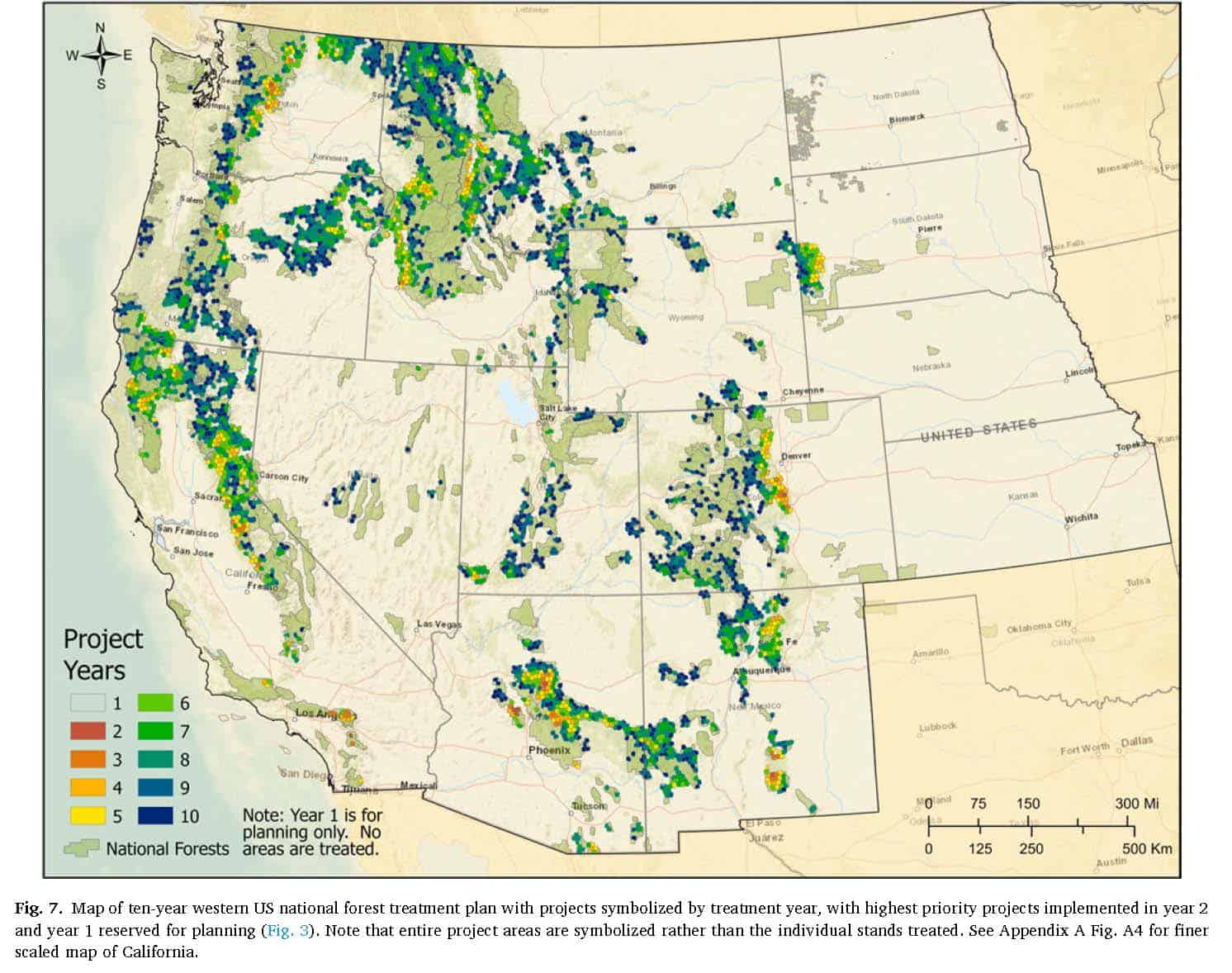
Premonitions of the Forest Service Wildfire 10 Year Plan

Note: this is from Ager et. al 2021. I don’t know to what extent these concepts or maps will be used in the final 10 year plan.


Chief Moore said many interesting things in his talk at the SAF Convention and in the Q&A’s that followed.  In this post, I’ll just talk about what he said about the Ten Year Plan for Fire.

Three caveats: first, the formal announcement of the Ten Year Plan is not out yet, so it may have changed since his talk; and second, I don’t have all the information but tried to piece it together from what he said and may have got something wrong; third, I am really lousy at taking notes.  Any mistakes are no doubt mine and not his.  People who attended the SAF Convention can watch the recorded presentation and correct me.

********************************

Wildfire is at a crisis level (remember Chief Moore was formerly the Regional Forester for the California Region, so he has been dealing with some of the worst ones).

He said that 98% of the Mendocino had been affected by wildfire in the last two years. In 2021, 2/3 of the town of Grizzly Flats, including the school and the Post Office were burned.

What can we do?  Reintroduce low intensity fire and strategically place fuels reduction treatments (and maintain them).

With increasingly bad wildfire behavior, small areas of treatments are not enough to help firefighters get control.   So-called “random acts of restoration” aren’t cutting it.

Using the scientific analysis in the Fireshed Registry, they found that 90% of exposure to communities could be reduced with work on 15% of the total land area.   But not only is it important to pick the right areas to reduce risk to communities, but also to plan for maintenance of those treatments over time.

Given that, Chief Moore assigned Brian Ferebee (whom many of us may remember from Region 2) to refine, adjust,  and implement the 10 year plan to address the wildfire crisis.  It’s a small team with representation from many parts of the Forest Service.  They will not be using the old approach- “everybody gets $5”.  In the first two years, they will identify projects where the NEPA has already been done and is a critical match with the Fire Registry/Scenario Planning effort.  Note that Scenario Planning can be used in a variety of ways at a variety of scales, but I think here it’s a shorthand for a certain way (see Ager and his group’s research) of dealing with fire and fuels planning at the national scale. However, that same group has done scenario planning incorporating a variety of objectives at a variety of scales, as we’ll examine in later posts.

If you haven’t been following this literature, you can see there is some overlap between this and the scenario planning for wildfire risk reduction in this and other papers by Alan Ager and his collaborators at the RMRS Fire Lab.  For the purposes of its possible application toward the 10 Year Plan, probably the best paper to read is this one Ager, A. A., C. R. Evers, M. A. Day, F. J. Alcasena, and R. Houtman. 2021. Planning for future fire: scenario analysis of an accelerated fuel reduction plan for the western United States. Landscape and Urban Planning 215:1-12. doi: 10.1016/j.landurbplan.2021.104212.   Fortunately, it can be accessed openly here.

From the conclusion section:

Our study demonstrated a top down approach to develop a large-scale prioritization to address wildfire risk to developed areas, and an approach to coarsely assess potential wildfire impacts and spatial in tersections with treatments during implementation. The results of the study are being used by the Forest Service to communicate a strategy to ramp up current levels of hazardous fuel treatments to the legislative branches that oversee the agency. The methods can be used by other national scale wildfire management agencies to develop strategic plans, including the assessment of planning risk (Mentis, 2015), i.e., the range of potential wildfire impacts on implementation of strategic risk reduction programs.

Future work can explore the effect of climate change as part of scenario analyses (Star et al., 2016) including assessment of planning risk for fuel treatment and restoration programs (Peterson et al., 2003). For instance, will extreme variability in future wildfire make the use of risk assessment ineffective as a prioritization method for 510-year restoration and risk reduction plans? Wider use of scenario planning models by land management agencies is consistent with systems thinking, data analytics, and prescriptive intervention (National Academies of Sciences, 2019), as a way to enhance foresight into natural resource management outcomes, and as part of addressing wildfire challenges in the near term future.

But back to the 10 year plan.. there will also be a monitoring plan to see how it works and to adapt.. plan,  implement, monitor and use that information to continue to understand and further improve risk reduction efforts.

Previous efforts to not do the “$5 for everyone” approach have foundered on the shoals of any priority setting mechanism (those left out/delayed aren’t happy).. so it will be interesting to see if this one, with a science base, and because the areas with most exposure and in the early years generally have lots of people (hence votes), will be successful.  Given the crisis, though, clearly something different needs to be done.

Finally, the Chief said it would be out soon (at the SAF Convention in early November), so I contacted a source at the FS earlier this week, and the reply was still “a few weeks.” So soon we should see how it comes out.

(Note: this post has been corrected in terms of Ager is at RMRS, and a miscopied quote from the paper and some other edits)

California and Oregon: Wildfires and Carbon Counting

It’s always interesting to observe differences between Oregon and California. It’s fun because they are both D states so it’s difficult (but not impossible, I’m sure) to partisanize issues.  They both grapple with approaches to climate change.  My hypothesis is that because OSU and UO have been the major universities for so long, and the state capitol is in the Williamette Valley, Oregon has more of a “mesic centric” bias than California.  There’s also a greater history (on the West side and the SW) of timber industry. Meanwhile, at UC Berkeley in the 1950’s, Harold Biswell was arguing for more prescribed fire.

It’s interesting to see how this plays out in the “who’s dishing out most carbon” controversy.  According to the Center for Sustainable Economy here:

A new study by researchers based at Oregon State University and the University of Idaho corroborates Center for Sustainable Economy’s 2015 and 2017 research demonstrating that logging is by far the number one source of greenhouse gas emissions in Oregon and that changes in greenhouse gas accounting rules are urgently needed to ensure that the climate impacts of logging are accurately reported. Both the new OSU study and CSE’s 2017 research estimate annual logging-related emissions to have averaged over 33 million metric tons carbon dioxide equivalent per year (Mmt CO2-e/yr) since 2000. This makes logging by far the largest source of emissions in the state, far larger than the 23 Mmt CO2-e/yr attributed to transportation – the leading source presently accounted for by the Oregon Global Warming Commission (OGWC) and the State’s Department of Energy.

And in this High Country News piece about the same study..

And Law’s research could have regional implications. She is working on a larger scale study looking at how land use affects carbon emissions across the West. Stanford forest carbon researcher Christa Anderson says studies like these are important to understand the impact of land use and forests in the carbon balance of the atmosphere.

Except, well, lots of other people watch carbon in California, for example, in this SacBee story that shows how it’s really difficult to decarbonize, even with a plethora of policies in place, in a State that really wants to. The whole article is interesting from that perspective.

The single-biggest contributor to the state’s emissions was the transportation sector, accounting for 40.7% of all emissions in the state, according to the report.

However, California may see a drop in transportation sector-related emissions for 2020 and 2021. The COVID-19-related shift to work from home resulted in a nationwide emissions dip of 15% for 2020.

“California could expect to see a similar level of decline in transportation emissions through 2020 and into 2021,” the report says, though it adds that that data is not yet available.

The second-greatest contributor to California’s greenhouse gas emissions were wildfires.

“Wildfires have always been a feature of the California environment, but they have been producing more (greenhouse gas) emissions than ever, fueled by the impacts of climate change,” according to the report.

In 2020, emissions from wildfires were greater than emissions from any other sector except transportation, with the August Complex Fire alone producing more emissions than the entire commercial sector.

The commercial and residential sectors also continued to increase the amount of emissions produced. From 2014 to 2019, commercial greenhouse gas emissions rose from 4.8% to 5.8%, while residential emissions rose from 6.1% to 7.9%.

Here’s a link to the study. For carbon counters, this group counted 106 MMTCO2e emitted by wildfires in 2020. Of course, it doesn’t look like other states divide up sectors quite the same way the OSU folks did. Seems like in California, at least, managing fire to reduce carbon emissions might be useful.

Of course, “where the best places, best sectors, and best technology to decrease overall emissions with least impacts to disadvantaged folks, and ideally, least negative impacts to anyone and to the environment” are larger questions than the forest community and our researchers alone can answer. Seems like in California, managing fire to reduce carbon emissions might be useful.

Large landscape connectivity – could the Forest Service be a leader?

I watched a webinar provided by the Center for Large Landscape Conservation titled “Legal Protections for Large Landscape Conservation,” part of which focused on “Habitat Connectivity and the U. S. Forest Service.”  That segment can be seen here from 4:15 to 19:05.  The presentation goes over the elements of Forest Service planning that could be useful for habitat connectivity.  It includes a couple of examples of “innovations” from the Flathead and Carson/Santa Fe forest plan revisions, but concludes that few plan components that address connectivity are likely to be very effective.  It cites a familiar refrain that the agency is “unwilling to commit to specific direction,” and “lack of commitment and interest from line officers.”  However, the presenter observed that the movement of the Forest Service toward more centralized planning organizations might provide an opportunity to look at connectivity as a broader regional issue, and to develop regionally consistent approaches to planning for connectivity.

What if the Forest Service was actually interested in conserving the species that use its lands but require connectivity across other jurisdictions and ownerships (as it is required to do, “in the context of the broader landscape,” a phrase used seven times in the 2012 Planning Rule ), and what if the Forest Service played a leadership role in facilitating such cross-boundary connectivity by promoting large-landscape conservation strategies?

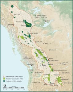
Maybe it would look something like what the Yellowstone to Yukon Initiative has accomplished since it began promoting large-scale landscape conservation in 1993.  As Rob Chaney reports in the Missoulian, they have recently evaluated the effectiveness of their program in “Can a large-landscape conservation vision contribute to achieving biodiversity targets?”  They found that in the Y2Y region where landscape connectivity was actively promoted, more public lands were dedicated to protection, more private lands were protected, wildlife highway crossing structures proliferated, and occupied grizzly bear habitat (as a proxy for actual benefits to wildlife) expanded.

Come to think of it, wouldn’t that be a great assignment for the Biden Administration to give the Forest Service (both the National Forest System and State and Private Forestry divisions) to promote its 30 X 30 conservation agenda?


BLM Leadership Moves Back to DC

Yesterday  Steve asked after Jon “what does the FS do well?”  And remember our own Colorado Senator Bennet was quoted as saying “When you combine the effects of climate change with the profound negligence of the federal government in terms of managing its national forests, these places are profound dangers to our communities and to our economy,” It seems like these are potentially finger-pointing statements (has finger-pointing replaced baseball as the national pastime?).  Whose fault? The “federal government” as Bennet says, or the specific agency?

Conveniently, we have a different federal agency (BLM) with a different culture, who also manages for multiple use, so perhaps that is an apt comparison.  And if I were to oversimplify (and echo former Wyo Governor Freudenthal) different stripes of admins generally push agencies to do more of some things and less of other things; while career folks negotiate these waves of preferred priorities, sometimes hunkering down and sometimes surfing. I think that there is something to be learned from comparing the two agencies, though, and fortunately many career folks have switched back and forth so there is information to be had.

One of the not so good comparisons is that (according to my sources) FLPMA requires/allows the head of BLM to be a political appointee.  This makes for an entirely different career/political interface than the FS.  As folks interested in good government, and what programs/policies (e.g. e-bikes, consultation, and so on)  make sense to be similar for the two agencies, it’s interesting to observe how this politicization plays out.

Here’s a story in The Hill about the move back of career leaders from Grand Junction:

The Bureau of Land Management (BLM) will move several of its leadership positions back to Washington, D.C., after a controversial Trump-era move to send leadership to Grand Junction, Colo.

An email sent out by BLM Director Tracy Stone-Manning that was obtained by The Hill states that the agency will “consolidate” most of its directors in Washington.

Specifically, it states that the director and deputy director of operations have already returned to the district, joining the deputy director for policy and programs. It said that 8 additional leaders including “most assistant directors and deputy assistant directors” will also return to D.C.

The message also said that 30 vacant headquarters senior positions will be based in D.C.

A spokesperson for the Interior Department, which oversees the BLM, confirmed the accuracy of the email that was obtained by The Hill, which specified the fate of the 11 leadership positions and 30 vacancies.

Spokesperson Melissa Schwartz also confirmed that a total of about 100 positions including 60 existing positions and the aforementioned 41 jobs will be based in D.C.

Thirty-six jobs will stay in Grand Junction, and are expected to be complimented by more yet-to-be posted jobs that were referenced in Stone-Manning’s email.

In 2019, the Trump administration announced that the Bureau of Land Management would move its headquarters from Washington D.C., to Grand Junction.

It argued that the move, which was completed last year, would put officials closer to the lands that they managed.

But critics saw it as an attempt to drive out career officials who may not have wanted to move west.

The Biden administration announced in September that it would restore its D.C. headquarters, but also maintain the Colorado office as its “Western headquarters.”

The Stone-Manning email that was obtained by The Hill states that two positions, the national conservation lands and community partnerships assistant director and deputy assistant director, will “anchor” the Colorado office.

She wrote that the office will “anticipate” posting additional positions that “reflect that office’s leadership role in BLM’s outdoor recreation, conservation, clean energy, and scientific missions, as well as outreach and Tribal consultation.”

Her message said that the fate of some positions remains up in the air.

My contacts in the Retiree Network say that replacing BLM SES folks (senior executives)  with those with favored political leanings is actually SOP for new color-changing administrations, and also it’s happening as we speak.  Also, I didn’t realize that BLM had a scientific mission.. at one point I thought that the USGS had taken over the research functions of all the Interior agencies .. but perhaps they grew back organically.

Anyone who knows more about any of this, please add.

The Black Hills National Forest timber debate

Nick Smith listed this South Dakota Public Broadcasting program in his Dec. 10 HFHC news email. The show lasts almost an hour.

In the Moment brings you an hour of conversations about the Black Hills National Forest plan and the debate over the timber count.

Seth Tupper joins us (back & forth with audio clips) for a conversation about the Data Quality Act and administrative action from the Black Hills forest products industry seeking corrections to a scientific report that recommends significantly reducing the timber harvest.

Ben Wudtke with the Black Hills Forest Resource Association discusses the Data Quality Act challenge and detailed examples of challenges to the General Technical Report published by the US Forest Service.

Kevin Woster joins us with thoughts from his conversation with U.S. Senator Mike Rounds regarding the loss of his beloved wife and his return to work in Congress.