Retired Forest Service Leader: Major Logging Reforms Needed In The Black Hills

The following interview comes rom South Dakota Public Broadcasting:

Jim Furnish grew up visiting the Black Hills National Forest with his family and later worked for the Forest Service. He rose through the ranks and served as the deputy chief of the agency from 1992-2002.

Furnish said he was saddened by findings about the Black Hills timber industry that were revealed in a February National Forest study.

“This general technical report clearly shows that the levels that they’ve been logging at are not sustainable,” he said. “In fact the technical report said if you keep logging at the level there won’t be any trees left in the Black Hills in 50 years.”

Furnish says it’s shocking that the Black Hills harvests the most trees out of all 154 National Forests, even more than the huge forests of the Pacific North West.

He said the forest is prioritizing timber over other natural resources and this will result in negative long-term effects for timber workers and fire safety.

This unsustainability violates the Multiple-Use Sustained Yield Act, Furnish said. He also said he’s found evidence of logging in areas that haven’t been approved through the National Environmental Policy Act.

Ben Wudtke is the director of the Black Hills Forest Resource Association, which represents businesses and workers in the timber industry.

“The partnership between the forest products companies and the Forest Service in the Black Hills has long been heralded by both the agency and the communities as a success in mitigating mountain pine beetle mortality, mitigating hazards for wildfires that threaten our communities and the lives of firefighters and the public alike,” Wudtke said.

He said Furnish’s vision for the forest would eliminate about 80 percent of the local industry.

The 22 minute interview with Furnish comes from a recent interview on SDPB’s weekday radio program, “In the Moment.” Listen to the full interview here.

Science Friday: More Climate Model Innards and Critiques

This is an interesting article in Science Magazine leading up to the upcoming IPCC report.  This one looks at some of the reasons and the “poorly understoods” that are causing models to run hot.

The models were also out of step with records of past climate. For example, scientists used the new model from NCAR to simulate the coldest point of the most recent ice age, 20,000 years ago. Extensive paleoclimate records suggest Earth cooled nearly 6°C compared with preindustrial times, but the model, fed with low ice age CO2 levels, had temperatures plummeting by nearly twice that much, suggesting it was far too sensitive to the ups and downs of CO2. “That is clearly outside the range of what the geological data indicate,” says Jessica Tierney, a paleoclimatologist at the University of Arizona and a co-author of the work, which appeared in Geophysical Research Letters. “It’s totally out there.”

To find out why, modelers probed the guts of the simulations, focusing on their representation of clouds, long the wild card of climate change. The models can’t simulate clouds directly, so they rely on known physics and observations to estimate cloud properties and behavior. In previous models ice crystals made up more of the low clouds in the midlatitudes of the southern Pacific Ocean and elsewhere than satellite observations seemed to justify. Ice crystals reflect less sunlight than water droplets, so as these clouds heated and the ice melted, they became more reflective and caused cooling. The new models start with more realistic clouds containing more supercooled water, which allows other dynamics driven by warming—the penetration of dry air from above and a subduing of turbulence—to thin the clouds.

But that fix has allowed scientists to spy another bias previously countered by the faulty cooling trend. In both the old and new climate models, the patchy cumulus clouds that form in the tropics thin out in response to warming, allowing in more heat than satellite observations suggest, according to a study by Timothy Myers, a cloud scientist at Lawrence Livermore National Laboratory. “Even though one feature of the climate is now more realistic, another that’s persistently biased has been revealed,” Myers says.


But this part brought back a memory from the 70’s…

So the IPCC team will probably use reality—the actual warming of the world over the past few decades—to constrain the CMIP projections. Several papers have shown how doing so can reduce the uncertainty of the model projections by half, and lower their most extreme projections. For 2100, in a worst-case scenario, that would reduce a raw 5°C of projected warming over preindustrial levels to 4.2°C.

Our silviculture professor at Yale, Dave Smith, had a skeptical view of forest vegetation models.  We were also, as graduate students, learning FORTRAN as a programming language (history, this was actually a graduate level course!). Dave told us something like “when trees grow too tall, they just put in a card that says “if the modeled tree height value is greater than 90, tree height equals 90″”. I don’t know if that was actually true about the JABOWA model, but this climate modeling intervention sounds a bit like the same thing.

The modelers hope to do better next time around. Lamarque says they may test new simulations against recent paleoclimates, not just historical warming, while building them. He also suggests that the development process could benefit from more time, with updates every decade or so rather than the current report interval of every 7 years. And it could be helpful to divide the modeling process in two, with one track focused on scientific experimentation—when a large range of climate sensitivities is helpful—and the other on providing a best estimate to policymakers. “It’s not easy to reconcile these two approaches under a single entity,” Lamarque says.

A cadre of researchers dedicated to the task of translating the models into useful projections could also help, says Angeline Pendergrass, a climate scientist at Cornell University who helped develop one technique for weighting the model results by their accuracy and independence. “It’s an actual job to go between the basic science and the tools I’m messing around with,” she says.

For now, policymakers and other researchers need to avoid putting too much stock in the unconstrained extreme warming the latest models predict, says Claudia Tebaldi, a climate scientist at Pacific Northwest National Laboratory and one of the leaders of CMIP’s climate projections. Getting that message out will be a challenge. “These issues don’t translate very well in practice,” she says. “It’s going to be hard for people looking to make some projection of a water basin in the West to make sense of it.”

Maybe people who manage resources like water just acknowledge “we don’t know, but things could be somewhat, very, or terribly much worse in a variety of ways due to climate change and a variety of other factors that may interact” and then see how the responses would play out, and what would be key decision points. It seems like that’s actually what they are doing, at least, as I recall Denver Water, ten or more years ago. Here are some examples.

Grist story: Good wildfire news? Evidence from the Bootleg Fire supports thinning forests.

This is an interesting story because it’s in Grist, and there are some great photos. It’s interesting to reflect on different researchers and what they use as evidence to support their conclusions, and how broadly they think they apply

“We have overwhelming evidence that when we treat forests by removing fuels, it generally — not always, you can never say always, but generally — moderates fire behavior,” said Maureen Kennedy, a professor who studies forest fires at the University of Washington, Tacoma.

Kennedy studied a similar situation as the one unfolding in the Sycan Marsh, following the 2011 Wallow Fire in Arizona. She looked closely at the places where people had thinned the forest around two small towns, Alpine and Greer, preparation that probably saved them. Forest treatments like this work by spacing out fuel, Kennedy said. When there is a continuous ladder of branches and small trees from the ground to the canopy, it allows fire to rise up into the treetops. And when trees are close together, fires move from one to the next, growing hotter and hotter. Trees that are farther apart, however,  encourage fires to fall to the ground. It makes sense, intuitively, but it’s still surprising when a wall of flame settles down and begins creeping across the forest floor, Kennedy said.

“No matter how many times I study it, no matter how much sense it makes in theory, it’s still amazing,” she said. “When you look at photographs from the Wallow Fire, that landscape was nuked, it was burning so hot that there were only blackened sticks that used to be trees left behind. Then, as you move into the treatment area the trees are brown, and then further in, they are green.”

The fire burned down the hill leaving a black area, as it encountered the treatment unit (brown area) and approached residences (green area). The treatment edge is obvious as is the change in fire behavior.
In this photo, taken after the Wallow Fire, the area treated is the brown swath between the blackened trees and the green trees. Photo courtesy of Timothy Sexton.

You can see the same thing in a photo (below) taken after the 2020 North Complex Fire, near Quincy, California. There, too, the fire mellowed when it reached the area where workers had removed fuels, said Hannah Hepner, program manager for the Plumas County Fire Safe Council.

The burn line from the North Complex fire where trees transition rapidly from black to green.
Photo courtesy of the Sierra Nevada Conservancy

”That aerial photo is pretty incredible, and that is precisely where the fuels treatment took place,” Hepner said. But, she cautioned, these images shouldn’t set expectations too high: Fire behavior is unpredictable, and some areas always burn more severely than others. Just across the street from that photo, she said, the fire continued to blacken trees — though even there, previous forest management allowed firefighters to get down a narrow road and save a wood shingled building.

>>>>>>>>>>>

“Examples abound: Forest management near Paradise, California, preserved the Pine Ridge School — a small island of standing structures amid the devastation of the Camp Fire. For years, other foresters thought John Mount was crazy for purposefully setting fires on the land that he managed for the electric company, Southern California Edison. But last September, the massive Creek Fire surrounded that land, licking up against it from three sides, but then settling to the ground and sparing trees.

Today, Mount’s heretical ideas have become mainstream. The story is different in coastal wet forests or in brushland, which evolved with less frequent fires. But it seems clear that the arid pine forests of the American West are much more resilient to fire when they are not packed with small trees, brush, and a century of dry foliage. “Fires are natural, inevitable, and necessary in these dry forests, and we removed them,” Kennedy said.”

“Mount’s heretical ideas” reminded me of Harold Biswell and his work, discussed in Jan van Wagdentonk’s 1995 article.

In that article it mentions that “A program to improve forage for livestock by burning ranch lands was active in the 1940’s and 1950’s, but gradually declined as concern about the liability for escapes increased. Understory burning, particularly in ponderosa pine, did not become common until the late 1950’s and continues today.”

It seems to me that these same ideas have been around for a long time,  but have continued to founder on the shoals of implementation.

Carter Niemeyer on the ongoing persecution of a public lands wolf pack

This is a heart-wrenching story from Carter Niemeyer about the on-going persecution of wolves in Idaho at the hands of the state and federal government.

Niemeyer retired in 2006 from the U.S. Fish and Wildlife Service where he was the wolf recovery coordinator for Idaho. In 2010 he wrote his first memoir, Wolfer. He published his second collection of stories, Wolf Land, in March 2016. – mk

I’m providing a Facebook story of ongoing persecution of a public lands wolf pack called the Timberline wolves in Idaho. This is a true account beginning in August of 2003, when I trapped and radio collared an adult female wolf and ear tagged a pup north of Idaho City, Idaho, an hour drive north of Boise.

The pack was new and I had just discovered them. I watched two adult wolves cross the road in front of my truck one evening and howled up pups that night nearby. I set traps and camped, catching the adult female alongside a Forest Service Road. The male pup was too young to radio collar so I just clipped a tag in his ear and released him.

I reported the discovery to the US Fish and Wildlife Service where I worked and also communicated with Suzanne Stone, the regional representative for Defenders of Wildlife in Boise. Suzanne had a working relationship with Dick Jordan, who taught science at Timberline High School in Boise and was an advocate for wolves and gray wolf recovery. The two contacted me to see if the new pack could be named the Timberline Pack since the school mascot was the wolf – no problem!

The Timberline wolves have always lived on public lands – part of the Boise National Forest. They primarily survive by eating elk. Life for the wolves was good with the exception of one major problem – domestic sheep graze annually on Boise National Forest and wolves, along with other predators, sometimes kill sheep. A federal agency known as Wildlife Services are notified by livestock producers whenever predators killed sheep or cattle.

It wasn’t uncommon for some Timberline wolves to be killed by Wildlife Services to pay the price of preying on sheep. Wolves were removed from protection under the Endangered Species Act in Idaho and Montana in 2011. That opened the door to wolf hunting which added to the mortality of additional Timberline wolves. Then foothold trapping was permitted too. The Timberline pack has persisted for 18 years though constantly persecuted – native wolves killed for eating non-native domestic sheep on a public lands national forest.
I’ve kept track of the pack, more or less, over the years due to my personal connection to the founding members back in 2003. The wolves have been able to outsmart people and persist from one year to the next but life isn’t easy staying out of the gunsights, foothold traps and neck snares. In recent years the breeding female of the pack raised several litters of pups although she was missing one of her legs – she obviously survived a bullet, trap or snare.

Last year, she and her pack lived in the Grimes Creek area not far from Garden Valley, Idaho but were invaded by domestic sheep. Wildlife Services set traps, caught and radio collared one of the adult wolves – the capture wasn’t very professional since other wolf researchers in the area found the collared wolf along a trail laying in the hot sun on a 90 degree day – researchers saw to its welfare and it did survive.

Coincidentally, my wife Jenny and I were in the same area with out-of-town guests, the Bureau Chief for the LA Times and his fiancée, who had never heard wolves howl in the wild. The same day the wolf was trapped we unknowingly camped nearby and howled up the Timberline wolves and their puppies that night. Any night that a person can hear wolves is an experience of immense pleasure and a unique opportunity shared by few. Though the sky and forest were thick with smoke from nearby fires and the temperature unbearable, the wolves provided relief and a distraction from the discomforts of climate change. We indulged and recorded the howls with a parabolic cone.

I was distressed to know that Wildlife Services were out to destroy this pack on public land. but not surprised. I made some calls and complained – killing predators is a tradition and culture in Idaho and the institutions that promote predator control don’t respond to criticism and carry on with the support of the governor, legislature, Idaho Fish and Game and those that decry wolves eating wild prey like deer, elk and moose or killing the occasional domestic sheep or calf – business as usual.

Winter came and the Timberline wolves continued to live on the national forest lands but hunters and trappers continued to harass them even after Wildlife Services went home. The old three-legged female who led the pack for several years through all of the dangerous, human dominated terrain finally miscalculated and walked into a trappers snare – she died either by strangulation or a gunshot. The pack was at risk once more, as they have been for nearly two decades.

But Timberline rallied this spring and had another litter of pups. One big problem is that the new breeding pair were wearing at least one radio collar that revealed their whereabouts to Wildlife Services and Idaho Fish and Game. For wolf packs like Timberline who have a track record of killing livestock – those agencies mark them with collars – not for study – but for lethal removal whenever the agencies decide they want to…….

Fast forward to the spring of 2021, the wolves gave birth to at least four puppies on public land going about their business of being wolves. BUT the rules in Idaho have changed or become lax when it comes to wolves – wolves are vermin now. The state of Idaho wants wolf numbers dramatically reduced – from 1500 to, perhaps, 450……… No more quotas on the numbers a hunter or trapper can kill with traps, snares, guns, and even hound dogs or night scopes on their rifles…….. just about anything goes these days.

In fact, beginning around May 18, 2021, the powers-that-be decided the Timberline wolf pups should die at their den. A pre-emptive strike – kill the wolf pups before the adult wolves kill the sheep. Yes, Idaho has moved on from wolf recovery efforts to wolf removal – maybe the late 1800s and early 1900s all over again……. eliminate as many as possible!

At least four Timberline puppies were killed before their lives even began. They weren’t permitted to live because domestic livestock prevails in Idaho – even on public lands. These aren’t the first pups to die. Wildlife Services has been killing wolf pups in the past. And private individuals too – a litter of at least 8 pups died in their den in the Idaho Pandhandle this spring when only a few days old.

Did you know that bounties are being offered and paid for dead wolves in Idaho? Wolves can be killed year round and the wolf killers can collect from $650-$1000. The Rocky Mountain Elk Foundation and Idaho Fish and Game Commission are contributing to the bounty fund (but they call it an “incentive”)….. The bounty payments could certainly be extended to wolf pups too……. no exceptions that I am aware of………. all you need to be is callous enough to crawl in the den and kill them by bludgeoning or gunshot………

The two adult wolves have lost their pups but the mother wolf still revisits her den…….. wondering where her pups have gone….. her instincts telling her she needs to feed and nurse them but only the smell of something horrible lingers at the den site…….. the stench of humans……… the kind that even kill pups that haven’t experienced life….. I’ve seen and heard it all in my career.

Post-fire tree mortality study

I came across a 2017 USFS paper about mortality on Doug-fir and ponderosa pine after wildfires.

Brief excerpts:

Only 8% of Ponderosa pine and 14% of Douglas-fir died within 3 years after fire. The amount of crown volume consumed, the number of bole quadrants with dead cambium and the presence of beetles were variables that classified most accurately,
but surviving trees in our sample displayed a wide range of fire injury making the accurate classification of dead trees difficult.

Injury to trees from wildfire and prescribed fire can produce mortality that is not immediately apparent and environmental
stress before and after a fire may also contribute to tree mortality in years after a fire

The Role of Qualified Insurance Resources in Protecting Homes/Structures from Wildfire

Qualified Insurance Resources (or QIRs) help homes survive fire by treating right around the homes and is included in homeowners’ insurance.  Here’s an example of Travelers’ Insurance in Colorado and California using Wildfire Defense Systems

Conceivably this hits the sweet spot of structural protection,  and homeowners pay for it through their insurance, so there is less of what economists call “moral hazard.”

Here’s a powerpoint (CGO wildfire conference.pptx)  by Monique Dutkowsky. The slides above are from that powerpoint. The powerpoint also includes some policy recommendations.  She will have a paper out in the next few months that covers this material in greater depth.

AFRC on Hazard Tree Removal Litigation

An item from the American Forest Resource Council‘s July newsletter. This edition has another entry on the topic, about hazard tree litigation in California.

Hazard Tree Removal Litigated

Last month the California-based Klamath Forest Alliance filed a complaint against the Rogue River-Siskiyou National Forest on a project that aims to remove fire-killed trees posing a danger to roads following the 2020 Slater Fire.

The Slater Fire Safe-Reentry Project proposes to remove hazard trees affecting 146 miles of travel corridors, including the mainline road connecting Cave Junction and Happy Camp. The Forest authorized the proposed actions using a Categorical Exclusion that allows various road maintenance activities. Among other things, the plaintiffs argue that the Forest Service violated the National Environmental Policy Act (NEPA) by failing to prepare an Environmental Assessment (EA) or Environmental Impact Statement (EIS).

The Rogue River-Siskiyou opted to defer consideration of any timber salvage on the Slater Fire and instead focus its planning resources on the Safe-Reentry Project. This decision has become the status quo for most National Forests impacted by severe wildfires as timber salvage, a silvicultural tool, has been deemed too risky due to threat of litigation and the associated delays that render fire-damaged timber useless to local manufacturers. To date, the four western Oregon National Forests, the Mt. Hood, Willamette, Umpqua, and Rogue River-Siskiyou, have only proposed area salvage on 750 acres of the 377,000 acres impacted by last year’s wildfires—that’s less than 0.2% of the burnt acres.

It remains to be seen if special interest groups will also challenge that 0.2%, but it’s clear that resources are being deployed to halt the removal of any fire-damaged trees posing hazards to Forest Service roads. Currently, the mere threat of litigation has resulted in the continued closure of hundreds of miles of Forest Service roads to public access. The Rogue River-Siskiyou has 146 miles of roads closed due to hazard trees related to the Slater Fire, the Mt. Hood has 257 miles of roads closed due to hazard trees related to the Riverside and Lionshead Fires, and the Willamette has 407 miles of roads closed due to hazard trees related to the Holiday Farm, Beachie, and Lionshead Fires.

In total, over 800 miles of Forest Service roads in western Oregon remain closed to public entry due to delays in removing hazard trees created by wildfire. By all reasonable accounts, the Forest Service has three options to address these hazards:

  • Close these 800+ miles of road indefinitely
  • Sell the hazard trees to timber purchasers for manufacturing into wood products
  • Use tax dollars to pay for the hazard trees to be felled and left on site

Given the state of the Slater fire litigation, and the threat of similar lawsuits on the other Forests, option three may be the only path forward. How much money this would cost is uncertain, but the Archie Creek Salvage EA prepared by the Roseburg BLM District estimated that it would cost up to $4 million to fell and leave hazard trees along roads associated with the Archie Creek Fire. This price tag applied across the vast Forest Service road network would be significantly higher. /Andy Geissler


Study: Ecological Forest Thinning and Rx Fire Lowers Insurance Premiums

Interesting paper by The Nature Conservancy and a large insurance company. It’s an “analysis that shows how ecological forest management, which reduces the risk of severe wildfires in fire-adapted forests, can be combined with insurance and significantly reduce insurance costs.” Press release here. The paper, “Wildfire Resilience Insurance: Quantifying the Risk Reduction of Ecological Forestry with Insurance,” is here. This illustration is from the paper:

“All Hands on Deck”Effort Toward National Forest Fire Planning?

This is from the NOI so I have no idea how current it is.


Remember, to many ENGO’s, we’re in a “climate emergency.” Which conveys a sense of urgency to do climate adaptation.  I don’t think we need to agree on what proportion of the current fire problem is caused by the human contribution to climate change to move ahead and realize that what we face today is a changed, and extremely bad, situation that needs serious and urgent attention. Back to the Climate Smart Ag and Forestry letters, here’s an idea from The Wilderness Society [1] :

“The Wilderness Society also encourages the USDA to adopt a multi-zone portfolio approach that guides wildfire management and restoration in large, contiguous areas across the landscape. A good, recent example of this kind of zoning system is the revised forest management plan for the Inyo National Forest in California. The Inyo plan designates four Strategic Fire Management Zones across the forest — Community Wildfire Protection, General Wildfire, Wildfire Restoration, and Wildfire Maintenance – and provides management direction designed to protect communities from wildfire risk while allowing wildfire to play a beneficial role in ecosystem restoration and maintenance.”[2]c.

If we add in the frustration associated with plan revisions by Forest Service employees, stakeholders and even law school professors (!) (Squillace, 2019)[1]:

“The time is long overdue for the multiple-use agencies to admit that the current land use planning scheme is not working, and that it cannot be fixed without fundamental change”.

We’d think that perhaps a fire amendment might work.. and another piece is that most ENGO’s seem to like EISs.. so… what about..

All hands on deck” effort on National Forest fire planning. Put a stand down on plan revisions and other major planning projects until each Wildfire Forest (forests for which wildfire is an important problem) has completed a forest plan amendment that addresses fire management zoning, wildland fire use, specific PODs or other strategic landscape fuel treatments design, and all other relevant fire issues. For example, I think it was WEG who suggested a focus on human-caused ignitions; there might be similarities across forests but also specific areas and approaches to target by Forest.

Such an amendment would require coordination with neighboring Forests, Tribes, state and private landowners and communities on locations of PODs and treatments.  Because many ENGOs prefer large landscape NEPA, these could be done as a plan amendment with an EIS for establishing PODs, as well as their upkeep through time (one and one NEPA). It’s possible that the “safety first” and the “departure first” points of view would iron themselves out during this process.  Some type of stakeholder advisory committee, including at the state level, might oversee and help with implementation, take advantage of state expertise including practitioners, natural resource professionals and state universities, increase alignment between local, state and federal efforts, and lift up problems and issues for resolution.

With the large fires we’ve been having, it would also be important to be able to change priorities and POD designs based on opportunities provided by fires, and keep those up to date. I’m not sure that going through the plan amendment-EIS process each time conditions changed would be realistic. On the other hand, an emergency calls for changes from business as usual.

Of  course, if we look at any Forest’s SOPA, we’ll see other permits and NEPA that need attention, so it’s impossible for employees to drop everything else. Still, we can ask the question “what does a climate emergency call for?” and “How far can we move from BAU to respond to such an emergency?

What do you all think?


[1] Squillace, M. 2019. Rethinking public land use planning. Harvard Environmental Law Review (43):415-477.

[1] https://www.regulations.gov/comment/USDA-2021-0003-1074

[2] USDA Forest Service. 2018. Land Management Plan for the Inyo National Forest, p. 75-79.


The Puzzle of Restoration/Fuels Priorities: Some National ENGO Views

I mentioned that I was working on a project to find areas of agreement between environmental groups of various kinds (ENGOs) and others on a variety of topics related to restoration, fuels management and wildfires. I looked at the Climate Smart Agriculture and Forestry public comment letters that USDA requested earlier this year.

Most, but not all, of the ENGOs agreed on the general concept of increasing the pace and scale of “ecological restoration.” This is a striking level of agreement, given the extensive history of disagreements around federal land management that we see here regularly on TSW.  There are also those groups whose letters said thing like “it’s a ruse to continue logging,” but it seemed more difficult or impossible to incorporate those views into an area of agreement.

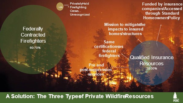
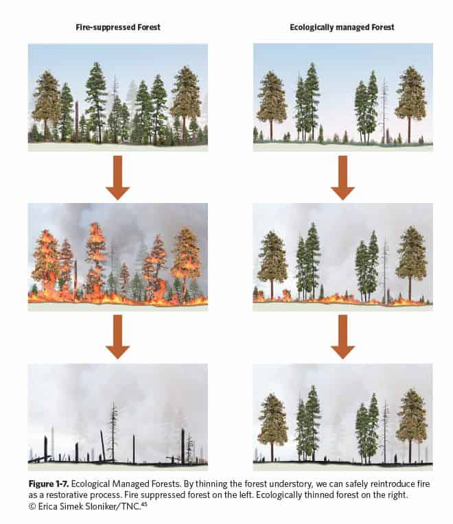
To restore historic conditions in ponderosa pine and mixed conifer forests, thinning and prescribed burning are generally accepted tools. Conveniently, these same treatments provide opportunities for changing wildfire behavior.  Strategically placing restoration treatments on the landscape as described in the POD (Potential Operational Delineation)[1] process that combines local expertise and modeling to specifically support incident management can blend concern for appropriate suppression and the perceived need for restoration in these systems.

There seemed to be a difference between the Environmental Defense Fund, The Nature Conservancy and Defenders of Wildlife, all powerful political actors on the national scene.

Defenders of Wildlife (Defenders) state in their letter[2]Rather than characterizing wildfire management as a matter solely of risk reduction, we recommend that a USDA climate-smart policy be based upon the bedrock principles of the Cohesive Strategy and seek to maintain and restore the ecological integrity of fire adapted landscapes; develop fire adapted human communities; and improve effective wildfire response.”

The Cohesive Strategy (2014)[3] never uses those words; the actual wording is: “Landscapes across all jurisdictions are resilient to fire-related disturbances in accordance with management objectives.” (p.3.) A search of the document did not yield the term “integrity.”

Now as you all know, I am a fan of using the term “resilience,” and not so much “integrity”, so I won’t further belabor the point.

Defenders later recommend (p. 17): “Develop planning and decision-making structures and processes that ensure that the highest priority areas within mixed ownership landscapes are addressed first; this would include areas around communities as well as areas that are most degraded and departed from desired reference conditions. “

It’s not clear but it sounds like they would prioritize areas most “departed from reference conditions” before PODs (these might not be “around” communities).  We could call this the “departure first” view.

On the other hand, the Environmental Defense Fund has a detailed prescription[4], with perhaps different priorities than  Defenders.  We might call this one “safety first.”

“Our national wildfire strategy should have two priorities: 1) Protect communities in the line of fire; and 2) Reestablish natural fire patterns to protect ecosystem values and sustainably manage fuel loads. Reestablishing natural fire regimes can only be realized when fuel loads, particularly in the West, are greatly reduced using both mechanical treatments and prescribed and managed fire. Implementation will require an updated wildfire triage approach to ensure that we address the most pressing threats to communities and human lives, first.”

Similarly, The Nature Conservancy (TNC)[5] (p. 13) supports “highest priority fuels management.”

“Like the Forest Service, the Department of the Interior investments focused on highest-priority fuels management would result in boots on the ground, restored landscapes and safer communities and water supplies while providing substantial rural and tribal jobs. There are both climate mitigation and adaptation benefits to all this work.”

Perhaps they are all saying the same thing, and the different staff authors just use different words.

To me,  the key question would be what exactly would need to be done, and how far away, to protect communities? Would that look like PODs? Who would be involved in prioritizing and designing the treatments, and what would be the role of “restoration” driven by historic vegetation ecologists and desired reference conditions, compared to “treatments designed to help manage fire” driven by fuels and suppression practitioners? One of the criticisms that led to PODs on the Arapaho Roosevelt, at least in the story I heard, was that the they seemed to be “random acts of restoration”.  But with landscape fuels and fire knowledge, these same treatments might have been placed in a pattern to also have landscape fire management benefits. There’s also the issue of what if a community wants some fuel breaks, and they’re surrounded by tree species that aren’t adapted to fire, or are adapted to stand-replacing fire, so the whole “restoration to reference conditions” may not work for them.

And maybe this (safety first vs. departure first) doesn’t matter, as the collaborative groups whose “zones of agreement” I’ve viewed either don’t seem to see this as a dichotomy or have resolved it. That’s why I’d like to hear from others, especially those from collaborative groups, on how these two maybe different sets of priorities are worked out in practice, or if it’s even an issue on the ground.


[1] https://forestpolicypub.com/2021/05/13/changing-the-game-using-potential-wildfire-operational-delineation-pods-for-a-better-future-with-fire/; https://cfri.colostate.edu/wp-content/uploads/sites/22/2021/06/CameronPeakFirePODsReport.pdf

[2] https://www.regulations.gov/comment/USDA-2021-0003-1246

[3] https://www.forestsandrangelands.gov/strategy/

[4] https://www.regulations.gov/comment/USDA-2021-0003-0949

[5] https://www.regulations.gov/comment/USDA-2021-0003-1303