WGA Webinar Today on Covid-19 Impacts to Natural Resource Management

Sounds interesting.. would anyone like to watch and share highlights/your thoughts? If so, please add in the comments below.

The Western Governors’ Association will host the webinar, COVID-19 Impacts to Natural Resource Management, from 10-11 a.m. MT on May 22.

The webinar will examine emerging challenges facing natural resource management professionals as a result of the COVID-19 pandemic. Panelists will discuss impacts to wildfire mitigation and suppression, invasive species management, wildlife management and more. Beyond immediate challenges, panelists will discuss potential long-term implications of COVID-19 to cross-boundary natural resource management.

This webinar is part of a series produced under the WGA Working Lands Roundtable. The Roundtable continues implementation of WGA’s natural resource-focused initiatives and serves as vehicle for discussion on cross-boundary working lands management.

Moderator: Kristen Averyt, Climate Policy Coordinator, Nevada Department of Conservation and Natural Resources.

Panelists: Dan Prenzlow, Director, Colorado Parks and Wildlife; Grant Beebe, Assistant Director, BLM Fire and Aviation; Lloyd B. Knight, Administrator, Division of Plant Industries, Idaho State Department of Agriculture.

Register for webinar

In California, A Push Grows to Turn Dead Trees into Biomass Energy

By the time new wood-fired power plants are online, most of the 147 million dead trees (so far) will have rotten and fallen — and some will have burned in wildfires.

From Yale:

In California, A Push Grows to Turn Dead Trees into Biomass Energy

As forests in California and the Western U.S. are hit by rising numbers of fires and disease outbreaks related to climate change, some experts argue that using dead and diseased trees to produce biomass energy will help to restore forests and reduce CO2 emissions.

High Country News’ Indigenous affairs desk looking to speak with USFS/BLM employees

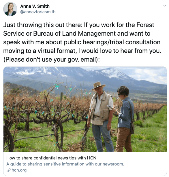
The Assistant editor of High Country News’ Indigenous affairs desk, Anna V. Smith, just sent out the following tweet:


If you are a U.S. Forest Service or Bureau of Land Management employee who would like to speak with Smith about public hearings/tribal consultation moving to a virtual format, here’s how you can get in touch with her. Also, here’s the link to the article “How to share confidential news tips with HCN.”

According to this 2018 NPR story “Just over half of Native Americans living on American Indian reservations or other tribal lands with a computer have access to high-speed Internet service, according to new estimates from the U.S. Census Bureau.”

Yesterday, Grist published this story, “Saving Chaco: As coronavirus consumes New Mexico, drilling threatens sacred land.” It included this information:

“Despite their concerns about the prospect of increased drilling, these Navajo communities were largely excluded from the BLM’s virtual public meetings because they either don’t have reliable high-speed internet access or lack it altogether, according to Daniel E. Tso, [who represents eight local government subdivisions, or chapters, within the Navajo Nation Council]. A 2019 Federal Communications Commission report found that less than half of households (46.6 percent) on rural tribal lands have access to fixed broadband service. Beyond the technological hurdles, many residents primarily speak Navajo, so virtual meetings conducted by the BLM in English present an added obstacle.”

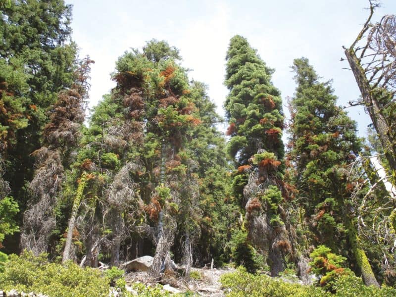
Patterns and Drivers of Recent Tree Mortality in Diverse Conifer Forests of the Klamath Mountains, California

A typical Shasta red fir (Abies magnifica var. shastensis) stand within the study area with substantial damage from dwarf mistletoe (Arceuthobium spp.), Cytospora, and fir engraver (Scolytus ventralis).

Thanks to the Society of American Foresters for posting a western round-up of papers in Forest Science and Journal of Forestry. I thought that this one was particularly interesting from several standpoints.Here’sa link.

1. Just because we leave trees alone doesn’t mean they will continue to do carbon storage. Maybe this works in the rain forests, but not so much where the cycle is “trees get established, get dense without fire, water can’t support so many trees and/or trees grow old, get bugs and diseases and die”.

2. It’s really hard or impossible to tease out how much of this mortality is due to changes in climate, past fire suppression, changes in bug and diseases, age of trees and so on, because through time they are all correlated. Back in the day when we wanted to tease out interactions, we would design experiments to do that. We could plant trees every 20 years, run fires through at different intervals, and wait 100 years (or 250) for our answer, except the climate would be changing all that time. So perhaps it’s time to simply say “we won’t know for the foreseeable future- if ever, but if it is climate we should do x, and if it’s age, we should do y, and if it’s fire suppression we should do z. Are x, y and z all that different? How sure are we that they will “work”? How much will they cost? What if we don’t do anything?”

3. From a pragmatic point of view, we need to consider a concept I’ll call “cats out of the baggery”.. one being climate change, and the other being non-native species. Even if we stopped climate change today, and kept all new non-native pests and pathogens from entering the country, managers would still have to deal with existing effects. Or not, in the case of this study, because it’s a Wilderness.

4. Philosophical question: the authors state.

Since this disease complex was first described in 1984, several management recommendations were made to increase the health and vigor of Shasta red fir stands, including selective removal of severely infested trees, and clearcutting and regenerating in heavily infested stands (Kliejunas and Wenz 1982). As of 2010, these silvicultural treatments were not yet prescribed and forest health continued to decline at this site (Angwin 2010), and in 2015, many of the severely infested stands burned in a wildfire (personal communication, Keli McElroy, USFS). Fire may be the best management strategy for slowing the spread of the disease complex, particularly in wilderness regions where silvicultural treatments are not feasible.

I think since it’s in Wilderness, management would mean simply mean no intervention, except maybe WFU?

5. It makes me wonder how much of what we think is conditioned by the most-studied forest areas. Note below how the Klamaths are different from other studied areas.
(CWD is climatic water deficit).

Several authors attribute recent die-off events to initial abiotic stress that predisposes trees to other agents of mortality, such as pests and pathogens. The region-wide dieback of piñon pine (Pinus edulis Engelm.) in the southwestern United States, for example, was attributed to the 2000–2003 drought accompanied by unusually high temperatures, which predisposed trees to attack by a secondary bark beetle species, Ips confusus LeConte (Breshears et al. 2005). Similarly, Millar et al. (2007) found that limber pine mortality in the Sierra Nevada was linked to increased temperature and decreased precipitation, followed by dwarf mistletoe, and finally by mountain pine beetle. We do not see surmounting evidence that recent tree mortality in our study area is linked to unusually high summer temperatures, as the rising temperature trend we observe is driven by minimum temperatures and is most pronounced in winter months (Figure S4, Figure 3). Our study is consistent with literature suggesting that fir engraver outbreaks are associated with increased evapotranspiration (Wright and Berryman 1978, Berryman and Ferrell 1988); however, similar to Rapacciuolo et al. 2014, we did not see an increase in CWD. This distinguishes our study from many other tree mortality studies in the Sierra Nevada, for example, where die-offs have been attributed to large increases in CWD in recent years (Millar et al. 2012, Mcintyre et al. 2015). Finally, we used a ten-year window (2004–2014) for calculating recent changes in climate parameters, but it is possible that a few years of extreme drought within this period could have accelerated mortality, as has been shown in other systems (Breshears et al. 2005). For example, the 2011–2014 regional drought almost certainly created physiological challenges for Shasta red fir trees that exacerbated drought stress from dwarf mistletoe, and increased susceptibility to fir engraver infestation, but further investigation is needed to tease apart the abiotic vs. biotic causal agents of mortality.

Changes in the historical disturbance regime of these forest types, particularly the effects of fire exclusion, may be partially responsible for the elevated levels of recent mortality in high density and/or more mature stands throughout our study area. Similar to other parts of California, forests in the Klamath region have notable signs of fire exclusion, including in-filling of small, shade-tolerant trees (typically white fir), and dense accumulations of litter and duff around older trees. Historically, this region is characterized by a mixed-severity fire regime, with a high frequency of fires prior to the twentieth century producing mostly low and moderate fire effects in most conifer vegetation types (Skinner et al. 2006). In the upper montane zone (where we observed the highest mortality), the estimated fire return interval based on studies done in nearby forests ranges from about 15 to 41 years (Taylor and Halpern 1991, Taylor 2000) According to Forest Service records, our study area has not burned in the past 100 years (Safford et al. 2011), and based on the aforementioned estimates, we determine that the upper montane zone in our study area has missed somewhere between two and six fire cycles. Our finding of higher mortality among smaller diameter trees is consistent with a growing body of literature suggesting that increased stand density and competition from fire exclusion are major contributing factors to the increasing mortality trend in western coniferous forests (Guarin and Taylor 2005, Maloney 2011, Millar et al. 2012). Furthermore, high stand density has been shown to amplify drought stress (Gleason et al. 2017) and increase the spread of pests and pathogens. While some of the mortality observed in this study is undoubtedly related to self-thinning in high density stands, the usually high numbers of recently dead and dying Shasta red fir trees (28%) coupled with the high levels of pathogens and forest insects is more indicative of a die-off event versus a slower change in community composition. In this case, the die-off was almost certainly precipitated by at least a decade of damage from dwarf mistletoe and Cytospora infestation.

Kentucky Heartwood: 13,163 Trees Illegally Sold on the Daniel Boone National Forest

13,163 Trees Illegally Sold on the Daniel Boone National Forest

Posted 4-27-2020
Read and share this post from our Forest Blog

On April 27, the Kentucky Resources Council sent a letter on behalf of Kentucky Heartwood to the Daniel Boone National Forest demanding an immediate halt to ongoing logging from the Greenwood Vegetation Management Project on the Stearns Ranger District in McCreary and Pulaski Counties. The letter comes after a series of surveys by Kentucky Heartwood found that the Forest Service has sold an estimated 13,163 more trees to loggers than what the Forest Service analyzed, and ultimately approved in their 2017 decision.

​Kentucky Heartwood also found that the Forest Service is violating mandatory Forest Plan Standards by marking trees for harvest in designated riparian buffer zones meant to protect streams. Riparian buffer violations were observed in tributaries that flow directly into Beaver Creek and Beaver Creek Wilderness, which provides habitat for the federally-threatened blackside dace (Phoxinus cumberlandensis).

Click here to read our report documenting our findings: Greenwood Project Monitoring Report April 2020

Trees marked for logging within a riparian corridor in violation of the Forest Plan. This stream leads directly in to Beaver Creek Wilderness and habitat for the federally-threatened blackside dace (Phoxinus cumberlandensis).
​​​
The violations found in the Greenwood project come shortly after Kentucky Heartwood documented Forest Plan violations and multiple large and ongoing landslides caused by logging in the Group One project in the Redbird District of the Daniel Boone National Forest in Clay and Leslie Counties.The Forest Service has been working to increase the “pace and scale” of logging across the Daniel Boone National Forest, with around 8,000 acres of new logging projects approved (or nearing approval) over the past several months. It appears that the Forest Service, in their efforts to sell more timber from the national forest, and sell it more quickly, is failing to monitor their own operations and are ignoring rules meant to limit environmental impacts.
The Greenwood project was developed between 2013 and 2017 after a series of public meetings, field trips, and public comment periods with 171 comment letters submitted to the agency in response to the proposal. The Forest Service ultimately approved 2,143 acres of commercial logging after several revisions. Most of Kentucky Heartwood’s surveys in the Greenwood project area focused on the Woodland Establishment management prescription, which affects 674 acres.​The Woodland Establishment prescription was designed to manage for mid-density, fire-adapted upland forests which were historically important in the area. However, after surveying 256 acres across 6 harvest units allocated to this prescription (including one site already cut), we found that the Forest Service was consistently cutting to about half the density of forest cover that was prescribed in the project. Another 36-acre stand prescribed for a Shelterwood Preperatory Cut was also examined and found to be marked more heavily that the prescription allowed, but not as severely as the Woodland Establishment harvest units.
This hyperlapse video shows one of the harvest units surveyed by Kentucky Heartwood. Blue paint means that the tree has been marked for harvest.
Kentucky Heartwood will continue in earnest until the U.S. Forest Service and Daniel Boone National Forest correct this timber grab and provide a full explanation of how and why it has happened.

Click here to read our report documenting our findings: Greenwood Project Monitoring Report April 2020

Forest Service Stories: Abandoned Trails by Susan Marsh

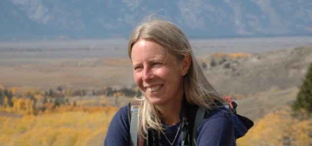
Susan Marsh

It’s been forty years since Susan Marsh and I worked together for the Forest Service on the then-Fremont National Forest in Lakeview, Oregon.  We always joked about the Fremont combining with the Winema and become the Fre-inema. Fortunately, though the Forests did combine, they go by the more professional-sounding Fremont-Winema.  Susan spent much of her Forest Service career as a landscape architect, and is also an accomplished writer, with several published books including War Creek, the winner of the May Sarton award for contemporary fiction. Here’s her website for more information.

here is a link to the whole story.

Abandoned Trails by Susan Marsh

Near Spread Creek, on the northern edge of Jackson Hole, I happened onto an abandoned trail.  Ancient blazes marked the route, each closed into a pitchy fist.  Logs cleared long ago lay dark with moss.  Pale conches billowed from their sawn ends.  The trail was so overgrown I stayed on it only by squinting for blazes as I shouldered through buffaloberry and climbed over fallen trees.  Drawn to whatever is abandoned, I followed the trail to where it vanished, at a ridgetop logging road.

The blazes led into a land made wilder by neglect.  Though I enjoyed having it to myself, it felt like a place forgotten.  The trail seemed to welcome my feet as if it missed the company of travelers.  I wanted to assure the trail that it was not abandoned after all, to bring it offerings of appreciation.  “Hiking is praying with your feet,” a friend once told me.  On that old trail, I prayed.

I brought my memories as offerings.  Memories of respite from the square-cornered, stay-in-the-lines world.  Memories of winding forest trails, with their wildflowers and smell of sodden leaves on an autumn day.

As I walked, I wondered how many decades had passed since the blazes on that trail were freshly cut and hoofbeats drummed along its tread.  The first forest ranger in the Spread Creek country, Rudolph “Rosie” Rosencrans, arrived in Jackson Hole in 1904.  He surveyed and drafted the first maps of the Buffalo Valley, part of the original Yellowstone Forest Reserve.  The wide switchbacks and regular grade suggest the trail was once laid out with skill and care.  Had Rosie himself, an engineer by education, defined the tread I followed?

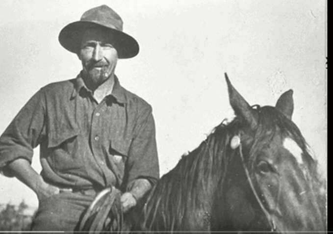
First Ranger of the Teton Division, Rudolf (Rosie) Rosencrans

Rosie left a record of his daily work, glimpses of a ranger’s life a century ago.  His diaries are on display in the historic Blackrock Ranger Station at Moran.  I spent a day last winter looking through them, entranced by the stack of lined yellow pages that once passed through Rosie’s hands. On his frequent trips from Blackrock to Antelope Springs, Rosie must have used the long-abandoned trail in Spread Creek, a shortcut through the foothills.  In his diaries I searched for mention of the trail.

Rosie wrote with a fine-nibbed fountain pen in elegant formal script.  He wrote of boundary marking, fence-building, trail-clearing, and backcountry patrols.  He recorded each day without embellishment or emotion, regardless of what happened.

“April 14, 1908.  Started for the upper Yellowstone country, made camp at 3 p.m. on Two Ocean Pass.  Started again at 6 p.m. and arrived at Shoshone Cabin on Throughfare at 11 pm.”  Thirty miles that day, on skis.

“July 9, 1907.  Started in the afternoon for my district [from the Supervisor’s Office near Jackson].  Crossing Grovont found mail driver drowned, thus helped to hunt for him and also to save one of his horses.  Being wet, stopped with Ranger Lee for the night.”

The wild frontier of Rosie’s day has now been rendered safe.  Technology has left little chance of such a drowning; mail arrives by electron.  The rivers are contained by dams and dikes.  We have tamed those parts of the world we use, and have left the wilderness to reclaim abandoned trails.

In 1912, Rosie exchanged his fountain pen for a typewriter.  By 1919, he traveled mostly by automobile instead of on skis or horseback.  Over the years, his diaries recorded more days of filing reports, fewer dramatic rescues and marathon patrols.  Work, even for an early forest ranger, was on its way to becoming what it is today–time at the telephone and computer, attending meetings, keeping files.  Safe, civilized, indoor work.

I first worked for the Forest Service in the summer of 1974, drawn by the romance of a job outdoors.  My first season, I went into the office for about an hour a week.  There I posted my time and picked up equipment for my work in the woods.  Now, after many moves and so-called career advances, I attend meetings, talk on the telephone, and sit in front of a computer.  Now when I clear trails, I do so on my own time, as an unofficial volunteer.

here is a link to the rest of the story.
*********************************
If you are interested in Rosie Rosencrans, here is a video that talks about Rosie and his life and his work, with Ranger Thomas Matza.

$150 hiking boots = “outdoor elitist,” says QuietKat CEO who wants to sell you a $6000 E-bike

Here’s a story about E-bikes and public lands by CBS in Denver. Here are some highlights:

Allowing e-bikes on non-motorized trails, as ordered by the secretary of the Interior Department last fall, is pitting traditional pedalers versus e-bikers as federal land agencies craft rules to implement the new order. Cyclists fear the embrace of electric-assisted pedalers could get all bikes banned from trails. Trail builders worry about impacts from motorized bikes that can reach more than 50 mph. E-bikers fret their opportunities to explore public lands could be relegated to motorized thoroughfares.

Thousands of public land users are flooding the public comment portals in what is emerging as one of the most controversial rules in years for the Bureau of Land Management.

For Jake Roach, the CEO and co-founder of QuietKat, the Eagle-based maker of off-road e-bikes, the conflict boils down to “outdoor elitists” who are able to power themselves into the backcountry.

“I think what you find is that currently in public lands access, it’s basically set up to really benefit the individual who has a lot of time and is in really good shape,” said Roach, whose QuietKat has seen explosive growth in recent years. “That is not necessarily the demographic of the typical American taxpayer.”

Roach is helping to mobilize the growing swell of e-bikers to sway federal land managers to allow the electrified rides. He hopes to spread the idea that e-bikes might not only open public lands to a wider range of users, but disperse those users across public lands.

“The first mile is crowded, but once you get past that first mile, it can get lonely,” Roach said. “Spreading out the public on public land can only add value. There’s a perception that outdoor elitists want to keep public lands for themselves and that’s not a fair assessment of how public lands should be used.”…

E-bikes are grouped into three categories. Class 1 e-bikes have a motor that kicks in when the rider is pedaling and tops out at 20 mph. Class 2 e-bikes have a motor that doesn’t require pedaling and also tops out at 20 mph. Class 3 e-bikes have motors that deliver power only when the rider is pedaling and go faster, up to 28 mph. Those classes are getting blurred though as e-bike technology grows. Southern California’s Hi-Power Cycles, for example, is making an 82-pound mountain bike with an electric motor that can hit 55 mph.

It’s that blurring that troubles Scott Winans, the longtime head of the Colorado Plateau Mountain Bike Trail Association. For more than a decade, he has guided his team of volunteer mountain bikers in building and maintaining hundreds of miles of rolling single track across the Western Slope. Since 1989, the group has built trails for non-motorized use, with banked berms and tight turns made for pedalers, not throttle twisters. The group’s trail work is largely on BLM land, making the Colorado Plateau a national testing ground for new e-bike access rules.

COPMOBA is supporting Class 1 e-bike access on some, but not all non-motorized trails it maintains around five communities in Western Colorado. They oppose Class 2 or Class 3 e-bike access on any non-motorized trails. But most importantly, the association wants land managers to follow the same public processes it followed for more than 30 years of trail-advocacy work.

Winans and his association have issues with the top-down order allowing e-bikes. He hopes this current round of public comment is just the first of many more rounds of public review allowing local BLM land managers to craft trail-specific management plans for e-bikes.

That’s the process Western Slope mountain bikers have been following for decades as they work to develop new trails on BLM land, Winans said. And it’s part of the process any time there’s a change to the agency’s local travel management and resource management plans.

“This is tough because we have such a solid community coalition that has come together to address trails from a local perspective and a bunch of stakeholders have worked together for many years to build a great plan and the feds, in essence, throw that out the window,” Winans said.

There’s a similar sentiment on the Uncompahgre Plateau, where farmers, hunters and water-users in the North Fork Valley spent decades crafting a plan that would limit oil and gas development in the valley only to have that plan dismissed earlier this year under the Trump Administration’s “energy dominance” agenda.

The system of public land management is not built for sudden shifts through presidential agendas or secretarial orders.

Highlighting recreation in land management processes is arduous, and it’s taken decades for the outdoor recreation industry to win a seat at the land-management table alongside energy and agricultural interests. It takes years of work to win approval for a new trail before shovels hit dirt, as evidenced by the 12 years of planning behind the Grand Valley’s new Palisade Plunge trail off the Grand Mesa. The community has to be shown the value of the trail to sway public support, land agencies have to work together and plans must follow environmental laws, Winans said.

“Getting a project from idea to implementation is just a huge, huge process,” he said. “Just because a secretarial order flows into the community and makes a statement that this change is very straightforward, well, just saying that does not make it true.”

Winans says e-bike advocates should be wary of celebrating a top-down order that suddenly changes decades of planning and work.

“All these long processes and tools, they are really important to keep in the toolbox for the future,” Winans said. “The ship that runs slowly moderates extremism. Sometimes you may hate that it’s so slow to turn, but sometimes it saves your bacon and prevents bad decisions from flowing into the system on a moment’s notice.”

The Boulder-based International Mountain Bike Association — or IMBA — is crafting its lengthy analysis of the proposed e-bike rule. The association’s executive director, Dave Wiens, said this public comment period will lay the foundation for trail-by-trail identification of e-bike access in future planning by the BLM.

He hopes the BLM requires environmental study for every trail network that shifts non-motorized use regulations to allow e-bikes.

IMBA, the umbrella organization for more than 200 local mountain bike associations, does not support Class 2 or Class 3 bikes on non-motorized trials. The group’s primary concern is that expanding access to e-bikes could lead to human-powered bikes losing access. That worst-case scenario looks something like this: If an e-bike is now regulated like a bike, maybe instead of fighting e-bikes it’s easier to change a trail designation to prevent all bikes.

“We’re well-positioned to be balanced in our assessments and consider any implications that could impact mountain biking at-large, in order to always protect access for traditional, non-motorized mountain bikes,” Wiens said.

Roach has seen his QuietKat company grow from a start-up in 2012 to a national leader in the e-bike industry. He considers QuietKat as part of the growing overlanding business, where travelers deploy well-equipped vehicles to venture beyond defined paths. While his QuiteKat bikes work well on roads, he’s focused on off-road and not necessarily competing against urban bikes.

His bikes are sold in 126 Bass Pro shops and about 150 independent retailers, and soon QuietKat will launch a branded bike with Jeep. A demo of the Jeep-branded QuietKat appeared discreetly in the carmaker’s Super Bowl commercial.

“Look, this is not about if e-bikes happen on public land,” Roach said. “It’s about when.”

Roach worries the BLM’s comment period may be used to identify areas where e-bikes should be banned. His concern is that locally approved plans may restrict e-bikes from bike trails and keep them contained to areas where motorized use is allowed. Which is not the expansion of e-bike access pushed by the Bernhardt order, he said.

“My thinking is that this process should help the BLM make the rules easier to follow and not make it more confusing for a wider array of locations,” Roach said. “The whole process is very antiquated and really needs a revamp. Our systems and our economies move so much faster now than they did in the 1960s, when most of these rules were made. And so do our bikes.”
 

The latest on forest plan revisions (and wildlife)

In the past couple of months the Forest Service has increased its family of forest plans revised under the 2012 Planning Rule to six.  The Chugach and Rio Grande national forests have joined the Francis Marion, Flathead, El Yunque, and Inyo.  The Forest Service revision schedule is over six months old, but the Helena-Lewis and Clark National Forest may be next.

Here’s what looks like a news release from the Rio Grande.

The plan prioritizes the use of active management to foster sustainable and productive use of the forest. Compared to the 1996 plan, this new plan is less prescriptive and emphasizes flexibility and commitments to working with the public. Management direction has been updated for all plant and wildlife species.

This seems to capture the mood of the Forest Service these days.  The only commitments it has ever liked are those they have to do any way, especially if they are check-the-box kinds of procedural commitments like “working with the public.”  In their “update” for wildlife, rather than commit to protecting wildlife as required by NFMA and the Planning Rule, they infuse the plan with discretion.  Here’s some examples of what the Rio Grande seems to feel (based on the best available scientific information) would “provide the ecological conditions necessary to: contribute to the recovery of federally listed threatened and endangered species, conserve proposed and candidate species, and maintain a viable population of each species of conservation concern within the plan area” – which plan components “must” do (36 CFR §219.9(b)).

DC-SCC-2: Structure, composition, and function of coniferous forests, including late seral forests, meet the needs of associated species, including species of conservation concern. (Forestwide)

There is a series of these desired conditions for different ecosystems that all say the same thing, which is “we’ll figure out what these species need later.”  The Planning Rule requirement is for “plan components” to meet the forest plan requirement, not for project-by-project decisions about how to protect at-risk species.  Let’s see if the standards and guidelines add anything …

G-SCC-3: To maintain viability of species of conservation concern, reduce habitat fragmentation and maintain structural conditions of sagebrush ecosystems through design of management activities. Patch sizes should not be less than 5 acres. (Forestwide)

TEPC-G-1: To avoid or minimize adverse effects to listed species and their habitat, management actions should be designed with attention to threatened, endangered, proposed, or candidate species and their habitats. (Forestwide)

Wow.  Apparently any “structural conditions” will do, but they at least appear to concede that there is a minimum patch size needed for some species in sagebrush ecosystems (this is actually the kind of “specific” desired condition the Planning Rule envisioned), but conversely there is not enough science to tell them what is needed for anywhere else.  If the courts say this is good enough, then the Forest Service has essentially excised the diversity requirement for forest plans from NFMA.  (Never mind the question of “how much did the Forest Service spend on forest planning to get THIS?”)  (This is a continuation of a pattern discussed here, and may lead to some of the same kinds of problems under ESA.)

Litigation update – end of April

I haven’t seen a Forest Service summary for awhile, but here’s some things from my list that are becoming old news:

COURT DECISIONS

In Dobbs v. U. S. Forest Service, the Tenth Circuit Court of Appeals upheld a decision by the Forest Service to deny a request for a special use permit to build a gravel access road through the Upper Kiamichi River Wilderness in the Ouachita National Forest in Oklahoma.  The court accepted the Forest Service’s determination that a foot trail would provide “adequate access” under the requirements of the Wilderness Act.

But with or without a road or cabin, Dobbs can use his property to the same extent that most of the other inholders in the area use their own inholdings. And if Dobbs eventually decides to build a cabin, the agency concluded that he can do so with pack animals and helicopter to transport materials. Given that this is a “technical . . . matter[] within the [Forest Service’s] area of expertise,” we owe their decision “especially strong” deference.

This trend, it noted, was consistent with practices nationwide because a review of National Forests found that “motorized vehicles were only allowed on roads that existed prior to the area’s wilderness designation.” Id. That same national review found “no cases of new road construction . . . except in the rare instance where a new road was authorized by wilderness legislation.” Id.

In NRDC v. McCarthy, the Utah federal district court held that an environmental review under the NEPA was not required before the BLM lifted a temporary closure order for the Factory Butte area in southern Utah.  The purpose of the closure was to protect threatened and endangered cacti species that had been or were at risk of being adversely impacted by OHV use.

The Tenth Circuit Court of Appeals has recognized that the BLM’s implementation of “such [temporary] closures are nondiscretionary,” meaning that the action is exempt from the NEPA’s environmental review requirements. The plain language of (43 CFR) § 8341.2(a) supports a conclusion that lifting of a temporary closure order is also a nondiscretionary action of the BLM which is exempt from the NEPA.

There were concurrent changes being made in the area’s Resource Management Plan, and the court addressed the question of why this particular situation didn’t have to be addressed as part of that process.

“[The] exemption of [temporary] OHV travel restrictions from the [RMP] process reflects the realities of public land management and allows the BLM to timely comply with its statutory mandate to `take any action necessary to prevent unnecessary or undue degradation of the lands.'” And the exemption of lifting temporary OHV travel restrictions from the RMP process enables the BLM to comply with its statutory directive to “manage the public lands . . . in accordance with the [RMP].”

(Note:  That quote in the last sentence should not be read as allowing site-specific travel planning decisions to remove OHV travel restrictions without complying with NEPA.  At most, it should be limited to cases like this one where a temporary closure is being lifted, and Forest Service regulatory authorities would be different.)

SETTLEMENT

The Tahoe National Forest has agreed to limit e-bikes to trails open to motorized vehicles in response to the lawsuit filed by the Backcountry Horsemen and others in a case filed in October and discussed here.

NEW CASES

A coalition of wildlife advocacy groups filed a lawsuit charging the U.S. Forest Service with continuing to grant elk feeding permits on the Bridger-Teton National Forest without adequate environmental analysis, a move ordered by the U.S. District Court of Wyoming in 2018.

As promised in the NOI described here, two environmental groups filed a federal lawsuit to stop a proposed underground natural gas pipeline from Idaho to Wyoming in the Caribou-Targhee National Forest, saying it would harm protected grizzly bears and other wildlife and would create a road through six roadless areas.  Here is the plaintiffs’ perspective.

The Wilderness Society has gone to court to obtain a draft EA related to this possible mine on the Superior National Forest (as we discussed here) through the Freedom of Information Act.

“While federal decision-making is supposed to be based on “substantial evidence,” there is little question that political calculations occasionally play a role as well. In this case, however, environmental critics of Twin Metals contend that the decision was not just partially political, but entirely so, and they believe it was directly at odds with the evidence developed as part of the two-year study.”

A complaint was filed in the federal court in January against USDA Secretary Sonny Perdue and the U.S. Forest Service alleging gender discrimination and harassment and retaliation against a woman who worked for the Green Mountain National Forest and claims a colleague harassed her.


Prediction tool shows how forest thinning may increase Sierra Nevada snowpack

Press release from the University of Nevada, Reno. Emphasis added. It makes sense that with more trees, less snow makes it to the ground. Thus, thinning can have an important impact on water supplies. But “when many trees are clumped together, they warm up and release heat”? I didn’t know that trees are warm-blooded! <grin>


News Release 

Prediction tool shows how forest thinning may increase Sierra Nevada snowpack

University of Nevada, Reno researchers design water quantity tool to help with forest-thinning plans

RENO, Nev. – The forest of the Sierra Nevada mountains is an important resource for the surrounding communities in Nevada and California. Thinning the forest by removing trees by hand or using heavy machinery is one of the few tools available to manage forests. However, finding the best way to thin forests by removing select trees to maximize the forest’s benefits for water quantity, water quality, wildfire risk and wildlife habitat remains a challenge for resource managers. The U.S. Forest Service is leading an effort to balance all these challenges in landscape-scale forest restoration planning as part of the Lake Tahoe West Restoration Partnership.

As part of this effort, University of Nevada, Reno’s Adrian Harpold recently led a team in developing a modeling tool to focus on the issue of water quantity. The tool predicts how different approaches to thinning the forest impact snowpack accumulation in Lake Tahoe, which controls how much water is available for downstream communities such as Reno.

“The snowpack we’ve relied upon is under pressure from years of fire suppression that increased tree density, combined with the effects of climate change and warming temperatures,” Harpold, natural resources & environmental science assistant professor with the College of Agriculture, Biotechnology & Natural Resources, said.

He explained that too many trees means less snow reaches the ground. In addition, when many trees are clumped together, they warm up and release heat, which can melt the snow on the ground. However, too few trees means the snowpack is less protected from the sun and wind, which also melt snow.

The tool, developed with funding from the College’s Experiment Station and the U.S. Forest Service, was built to specifically model the west shore of Lake Tahoe, which the team felt was a good sample of the Sierra Nevada forest. The team initially created a small-scale high-resolution model using data collected with 3D laser scanners, called “LiDAR.”

“The LiDAR data lets us see individual trees, which we use to ‘virtually thin’ the forest by taking trees out of the model,” he said. “As such, it lets us create a thinning experiment that’s realistic. We can then represent different management actions, such as removing trees below certain heights.”

His team, including the post-doctoral scholar Sebastian Krogh, graduate student Devon Eckberg, undergraduate students Makenzie Kohler and Gary Sterle, the College’s Associate Professor of Remote Sensing Jonathan Greenberg and University of Arizona’s Patrick Broxton, tested the model’s accuracy by conducting thinning experiments and comparing the predictions to measurements in the real forest. Results were discussed in a recently published article on the proof-of-concept for using high-resolution modeling to predict the effect of forest thinning for snow, for which Harpold was the lead author.

Once the team determined the model was working correctly, they increased the model size to represent Lake Tahoe’s western shore. Results are discussed in another recently published article on using the model to predict the effects of forest thinning on the northern Sierra Nevada snowpack, led by Krogh with Harpold, Broxton and the Forest Service’s Patricia Manley as co-authors. Their experiments showed that overall, more trees removed means more snow maintained. However, there are beneficial ways and detrimental ways to remove trees. The method that appeared to be most effective was removing dense trees that had many leaves and branches and were shorter than about 50 feet, leaving behind taller trees. There were also differences in effectiveness depending on the elevation, the slope and the direction the slope was facing.

Harpold plans to continue expanding the model, testing to see if it will work for Lake Tahoe’s eastern shore and in the American River Basin, with the ultimate goal of providing a tool for Forest Service decision-makers and others to inform their forest-thinning plans.

The water-quantity tool is one of many different modeling tools being developed with funding from the Forest Service as part of the Tahoe-Central Sierra Initiative, which aims to quickly restore the forest to improve the health and resilience of Sierra Nevada mountains and maximize the benefits that the forest provides.

“My decision-support tool for water quantity would be a smaller piece in a larger toolkit to help determine how and where to thin the forests,” Harpold said.

Other tools being designed to predict forest-thinning impacts include a tool to predict impact on wildfire spread, a tool to predict impact on smoke, a tool to predict impact on endangered and threatened species, a tool to predict sediment flow into Lake Tahoe and a tool to predict economic impact.

###

For more information on the water-quantity tool, see: “Increasing the efficacy of forest thinning for snow using high-resolution modeling: A proof of concept in the Lake Tahoe Basin, California, USA” in the journal Ecohydrology, and “Using Process Based Snow Modeling and Lidar to Predict the Effects of Forest Thinning on the Northern Sierra Nevada Snowpack” in the journal Frontiers in Forests and Global Change. For more information on the larger forest-thinning project, visit the Lake Tahoe West Restoration Partnership or Tahoe-Central Sierra Initiative websites.