Let’s Discuss: Bloomberg’s Wildfire Resilience Plan

)

I’ve been trying to collect information on different D candidates’ positions on various federal lands policy issues. I was thinking we could take a candidate per day, but perhaps should have started sooner. Here is a link to a pdf

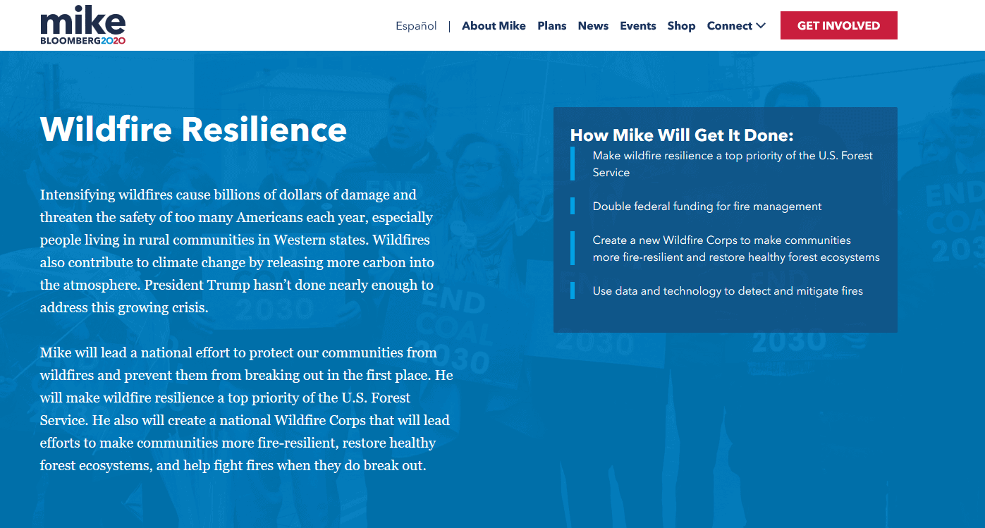
Mike will set a goal to reduce deaths and property losses from wildfires by 50% within four years. He will direct the U.S. Forest Service to coordinate with federal, state and local agencies, tribal leaders, environmental groups, rural communities, private timber companies, utilities, and the insurance industry to develop fire management plans for each state at risk.

Do States already have fire management plans? Would the goal possibly interfere with suppression choices to do WFU?

Double federal funding for fire management
Mike will double federal funding for fire management to $10 billion and devote half to mitigation efforts. These new resources will fund efforts to rapidly increase the pace and scale of forest restoration, reducing the risk of catastrophic wildfires. Federal money will also be directed to help fireproof homes and communities, develop evacuation plans, and strengthen other local resilience efforts, which will save lives, create jobs, reduce the costs and dangers of firefighting, and bolster insurance networks.

Of course, Presidents can’t actually double funding, but “increasing the pace and scale of forest restoration” sounds like another billionaire’s (currently President) policy. It’s nice to see some apparently bipartisan ideas.

Create a national Wildfire Corps to make communities more fire-resilient and restore healthy forest ecosystems
Mike will create a national Wildfire Corps, a new partnership between federal, tribal, state and local governments and communities. The Corps will hire and train thousands of workers to lead efforts to make communities more fire-resilient and restore healthy forest ecosystems. It also will provide enough firefighters to quickly contain wildfires when they break out.

I’m not sure that there is a lack of people if they were funded, perhaps there is, and/or a lack of training. I wonder if we asked fire people in communities would they see the same needs?

Use data and technology to detect and mitigate fires and to improve firefighting techniques. Mike’s administration will help fund a network of sensors and cameras to detect fires faster and more cheaply, and will strengthen the communications grid for public safety and emergency notifications. It will partner with state authorities to use satellites, drones, firefighting aircraft, and AI and communications technology to help predict the spread of fires and improve firefighting techniques.

Better technology.. why not?

What do you all think of these ideas?

Two Stories from Wyoming: Not Shooting Goats from Helicopters, Plus Potential Million Acre Land Purchase

Map from the Governor’s Office via Wyofiles. For those of you who can’t read county names, yes, parts are in Utah and Colorado
Following up on the Grand Teton Park aerial goat-shooting story here, it appears that the Governor appealed to David Bernhardt the Secretary of the Interior after repeated letters from the head of Wyoming Game and Fish had no impact on the federal decision. Here’s a link to the Cowboy State Daily.

Bernhardt’s order to “stand down” came in a phone call to Gopaul Noojibail, acting Grand Teton Park superintendent late Friday. The call was made after Governor Gordon shared with Bernhardt a strongly-worded letter sent to Noojibail Friday afternoon. In the letter the Governor criticized the Park Service’s choice to “act unilaterally aerially executing mountain goats over the State of Wyoming’s objections.”

Perhaps there must be an interesting backstory there.

In other Wyoming news, state legislators are looking at buying a million acres (yes, a million!) of land.

Here’s a link to a story about it, and a statement by the Governor here (excerpts below) in the Cowboy State Daily:

Wyoming is not looking at this purchase to try to become a developer or a mining company; rather, we see the land grant opportunity as a way for the state to expand the areas where we already have expertise: land and mineral management.

This opportunity is not just about the money. This acquisition has enormous potential benefits for multiple-use that are valuable to all citizens of Wyoming, giving us the opportunity to assemble one of the largest contiguous pieces of public land in the continental United States. One that will benefit wildlife, hunters, fishermen and outdoor recreationists while achieving responsible development of rich natural resources.

Opportunities like this don’t come along very often. The land grant has only changed hands twice in its 150-plus year history. It’s likely that this would be the largest government purchase of private land since the United States purchased Alaska. That’s a big deal.

In this interesting article by Cat Urbiquit (who doesn’t seem to be a fan of the purchase), she talks specifically about how public public lands are in terms of recreation. Apparently Wyoming State Lands may be more restricted in terms of recreation than multiple-use federal lands such as BLM and FS. I think what is also interesting is the difference in terminology between “public” lands “owned by a government entity of some kind” versus “open to the public for various uses or not.” In many discussions people use the word to mean different things, which could contribute to the phenomenon of talking past each other.

State trust lands are to be managed to produce revenue, so they aren’t comparable to federal “public” lands like that of the Bureau of Land Management that are to be managed under a multiple-use mandate. But the State Land Board has adopted rules allowing the “public the privilege of hunting, fishing, and general recreational use on state trust lands.”

Recreational privileges on state trust lands come with sideboards: the lands must be legally accessible, and off-road use, overnight camping, open fires, and anything else that would damage the property are prohibited on state trust lands.

So you can hike, fish, and play on state trust lands by day, but no camping, fire pits, or charcoal grills (except in camping areas established by State Land Board). Cultivated croplands on state trust lands are not open to public use.

The state may issue permits for furbearer trapping and outfitting/guiding on state trust lands, (either exclusive or nonexclusive), and outfitters may be allowed to establish camp sites on exclusive permits.

Some state trust parcels are closed to all public use, while others have seasonal restrictions on public use, or restrictions on the discharge of firearms, hunting, or the use of motorized vehicles.

Cool New Tool for Coloradans: Recreation Impact Monitoring System

If there were a The Smokey Wire Fix Not Fight Timely Innovation Award, this effort by the Colorado Mountain Club would be a winner. We’ve been talking about keeping track of recreation impacts and here is a way for volunteers to provide information, and also for volunteers to help fix the problems. I’m sure others have been frustrated by wanting to report something on a trail and not having the time to figure out which District you’re on, or want to call around to find the Recreation staff. And if it’s that hard for retirees, it must be more difficult for others.

Below is some information about the RIMS app and here’s a link to an overview pdf. Here’s the website where you can take a training video and learn to use the app.

Features
• Geo-located point data
• Drop-down surveys & objective metrics
• Photos
• Online maps & functionality
• Cloud sync for real-time data

Users
• Agency Staff
• Stewardship Organizations
• Trained Volunteers
• Enabled for Android or Apple devices
• Simple & Easy to Use!

Accessibility
• Trail, Campsite, Sign, Facility & Visitor Use
Assessments
• No Cost for data collection
• Custom Assessment Development (invasive species,
wildlife monitoring, etc.)

The CMC folks worked with agency staff to develop it, and here’s how agency staff and volunteers can use it:

There are a few ways both agencies and stewardship groups can access the data –

· All assessments are viewable through the RIMS app itself and users (including agency staff) can filter the data by assessment type and date. We are adding a new “sharing” function in the next month which will allow a user to send the details of an assessment directly via email.

· The webviewer is a browser-based tool that displays assessments on a map an allows for some additional filtering.

· Finally, our customized reporting dashboards are available for land managers or stewardship groups this spring and include geographically filtered data (e.g. only assessment within a Forest Service Ranger District’s boundaries) as well as charts, graphs, maps, and full data exporting capabilities. The dashboards can also generate automatic email notifications on a daily/weekly/monthly basis to help direct rapid response stewardship work. For example, a trail crew leader might want a weekly report of all the new downed trees that have been reported on the district to help inform where to direct staff or volunteer efforts.

The workflow for resolving issues is as follows: App users can re-assess any survey in the RIMS app to update the current conditions at that location. For example, if a downed tree is reported June 1 and a volunteer hikes that same trail June 7 to remove the downed tree, they can re-assess the first survey, remove the record of the downed tree and the issue will be marked as resolved within the app database. If for some reason the volunteer does not use the app to report the work they completed, another user could hike the same trail at any point after that and re-assess the original survey to mark it as resolved. The re-assessments are also helpful for measuring change over time: for example, re-assessing a dispersed camping area year after year to measure growth of the site, increased vegetation damage, etc.

We are still working through some details of this workflow but the ideal scenario in the future is that we have enough folks using RIMS and re-assessing issues that we always have a relatively current view of current conditions on the ground.

Here’s a link to a report from Chaffee County from July to November. My pet peeve that this could help with are dispersed campers that don’t respect the two week camping ban, or leave their trailers in a spot for what appears to be all of hunting season, taking up the choicest spots and not actually being there.

The image above is from the Chaffee County report. The CMC folks’ intention is to ultimately go national, so please spread the word in your area!

Climate Science Voyage of Discovery. V. The Satellite Gaze and Grazing Animals

We’ve seen before that “where you drop the pin” (where you start) or at what scale you choose to examine a problem can lead to fundamentally different conclusions. In some cases, there seems to be no formal institution for the type of communication between people on the land, and people modeling the land. We might call this the “satellite gaze” after the idea of the “imperial gaze.”

Imperial gaze, in which the observed find themselves defined in terms of the privileged observer’s own set of value-preferences.[8] From the perspective of the colonised, the imperial gaze infantilizes and trivializes what it falls upon,[9] asserting its command and ordering function as it does so.

So let’s look at beef production, and the study that the chart above was based on. The authors are from Oxford, and published in Science. According to Our World in Data, in this study, the authors looked at data across more than 38,000 commercial farms in 119 countries. If you look at the study itself, (and the errata) the modeling is mind-bogglingly complex.

Science has a section for e-letters. Ilse Kohler-Rollefson of the League for Pastoral Peoples and Endogenous Livestock Development wrote:

This article, both in its database and its conclusions, totally ignores the vital role of livestock for the life and livelihoods of the people living in the non-arable parts of the world. Without livestock large parts of the world wold become uninhabitable. Please see http://www.ilse-koehler-rollefson.com/?p=1160
In addition, one wonders about the usefulness of “land use” as indicator for judging the environmental impact of a food production strategy. Applying this indicator to livestock production would give preference to intensive and factory animal farming over extensive herding.

When this graph was posted on Twitter, I and a fellow from Sasketchewan and a woman from Ireland pointed out that some people raise animals because (1) people can’t raise anything else, or (2) in the case of Sasketchewan, the prairie was plowed for wheat, canola and lentil monocrops, which are arguably worse for biodiversity. I pointed out that there is no land conversion associated with beef in the prairies and the answer was that “if you look overall at beef, you have to account for the env cost of land converted to corn/beef.” My point being that consumers don’t have to look overall at beef, they only have to look at the beef that they’re buying. Who decided that we needed to make a purchasing judgment call based on a global average, and call it “science”? You can follow the Twitter feed here.

A variant of the same convo occurred in the letter section of New Scientist this month:

You might think that as a livestock farmer I would resent vegans claiming that my way of life is unethical, and you would be right. You quote Michael Clark saying that eating animals fed on plants must be less efficient than people eating plants. This ignores the fact that many herbivores can, and do, get much more feed value out of plants than people. What’s more, much of the north and west of the UK and Ireland can only be farmed practically using grazing animals.

The editor writes:

Much of the world’s beef is now produced in intensive feedlots – pens without pasture. This may have a lower carbon footprint than pasture-fed beef. We suspect that most of that is done on fertile land, not rough grazing. It is even harder to find figures for other meats. We note that in the UK, upland sheep production is only marginally viable even with EU subsidies.

There are two more ideas here- that feedlots (feeding animals lots of grain) produces less carbon than feeding animals grass. Again, the editor “suspects” that most of it is done on “fertile land”. And upland sheep production is only “marginally viable” even with subsidies.

At the same time in the US, grassfed beef is undergoing popularity for environmental reasons, and as as of 12/27/2019, USDA FSIS published new guidelines clarifying grass-fed labeling.

As this HuffPost piece says:

Our best bet is to educate ourselves about where our meat (and all our food) is coming from and the practices used to raise it.

“Don’t be afraid to ask questions,” Williams told HuffPost, adding that consumers have an incredible effect on the market. “Go to the grocery store and ask for products that are regeneratively produced. Go to restaurants and demand grass-fed meat and dairy. You’ll be amazed at how quickly those businesses will respond.”

A complex question indeed. What does “the science” say? Who produced it, and how relevant is it to our lives and choices?

White House proposal eliminates Forest Service research

The following article was written by Marc Heller, E&E News reporter. It includes perspective from Smokey Wire contributor Andy Stahl, executive director of Forest Service Employees for Environmental Ethics.

The Forest Service is looking to shift research away from wildlife in national forests and toward wildfire management, according to budget documents.

In its proposed spending plan for the fiscal year beginning Oct. 1, the service said it intends to eliminate research funding for fish and wildlife and close a research station in California. Staff would be reduced, although researchers would be given the opportunity to relocate within the Forest Service.

The wildlife and fish research totals $22 million this year.

“The proposed budget requires difficult decisions about what research stations and programs would continue to operate,” the Department of Agriculture said in a memo to staff, detailing the planned budget rollout. The administration presented the fiscal 2021 budget proposal to Congress on Monday.

“Making these decisions will allow the Forest Service to focus its resources on its highest priority science activities,” USDA said. “These highest priority science activities are those which make the greatest contribution to the agency’s land management responsibilities.”

In the memo, obtained by E&E News, the department told staff the proposal doesn’t mean the Forest Service is turning away from science and research, but rather that it’s realigning its research priorities to reflect the relative importance of wildfire and forest health. The proposal also would eliminate funding for research related to recreation, saving $9 million.

The forest inventory and analysis budget would climb 2%. The service would also invest more than $12.5 million to strengthen the link between research and wildfire suppression operations, the department said.

“The Forest Service will continue to be a national leader in conducting applied science to inform forest management and improve forest conditions,” USDA said.

Cutting research is likely to raise objections in Congress, particularly from Democrats who view the Trump administration as hostile to science. The department appeared to anticipate that line of inquiry, posing in a question-and-answer section of the memo: “This budget is yet another example of this Administration’s war on science. How can you justify this huge cut to research and say that you will still have enough capacity for a viable research program that will support the management of the Nation’s forests?”

The department’s answer, in part: “Selecting priority research areas on which to focus resources is essential to maintaining the quality of the Forest Service’s research enterprise and represents the agency’s commitment to producing high-quality, impactful science.”

Research on wildlife and fish directly affects Forest Service decisions on land use, including logging that has impacts on wildlife, said Chad Hanson, a forest biologist with the John Muir Project in California who is opposed to logging on federal land.

The research has sometimes been at odds with timber industry priorities, said Andy Stahl, executive director of Forest Service Employees for Environmental Ethics.

“Fish and wildlife research reformed Forest Service logging. But for the work of a generation of Forest Service fish and wildlife scientists, old-growth forests would all be stumps today,” Stahl said.

Other potential points of contention are the proposed closure of the Pacific Southwest Research Station in Albany, Calif., and the International Institute of Tropical Forestry in Puerto Rico. The research station in California is the smallest of the Forest Service’s five research and development stations and can be merged with the Pacific Northwest Research Station, the department said.

USDA said the proposal would cut 287 staff years, although the proposal didn’t say how many researchers would be affected. Scientists working on forest inventory and analysis, for instance, would be kept on at other facilities, the department said.

In the budget justification document presented to Congress, USDA said, “These closures would require the use of reduction in force authority, voluntary early retirement authority and voluntary separation incentive authority.”

USFS Seeks Help Identifying Inaccessible Lands- Nominations Close on March 12

I originally read about this in the Wyoming Livestock Roundup, and then searched online for other information. I only found it on hunters’ and livestock sites and some local papers in Idaho and Montana, so perhaps deserves further distribution. This seems like a win-win for everybody.. except there might be more recreation environmental impacts by adding recreational access. I don’t know if anyone’s worried about that. Everyone seems to support the LWCF.

The U.S. Department of Agriculture’s Forest Service is seeking public assistance to help identify national forest and grassland areas where the agency can provide greater access to hunting, fishing, and other recreational opportunities.

The agency today posted a draft list of about 90,000 acres of Forest Service land where hunters, anglers, and other recreationists are allowed but have limited or no legal access to the areas. The outreach is tied to agency efforts to implement the John D. Dingell, Jr., Conservation, Management, and Recreation Act of 2019 that mandates federal land management agencies work to evaluate how to expand access to public lands.

The Forest Service is seeking nominations that describe federal lands not on the list. The lands identified must be managed by the Forest Service, be a minimum of 640 contiguous acres, and be unreachable by foot, horseback, motorized vehicle or nonmotorized vehicle because there is no public access over non-Forest Service land, or the access is significantly restricted.
“National forests and grasslands play host to some 300 million hunters, anglers, and other recreationists each year,” said Forest Service Chief Vicki Christiansen. “The input we receive will go a long way toward helping the Forest Service provide even greater access and opportunity for the people we serve.”

The public nomination period to identify parcels for inclusion on the agency’s priority list will close on March 12, 2020. A final priority list will be published soon after and will be updated at least every two years until 2029.
To nominate a parcel of Forest Service land for consideration, email [email protected] or write to Lands and Realty Management, ATTN: Access Nominations, USDA Forest Service, 1400 Independence Ave. SW, Washington, DC 20250-1111. Nominations must include the location of the land or parcel, total acreage affected (if known), and a narrative describing the lack of access.
*****************
Background
The John D. Dingell Jr. Conservation, Management, and Recreation Act of 2019 is a broad-based law that sets provisions for various programs, projects, activities, and studies in the management and conservation of federally managed natural resources. The law includes steps agencies must take on how federal acres that are now essentially inaccessible may be opened to the public. The collective work of the Forest Service and interested citizens will help the agency decide how to reasonably provide access through such measures as easements, rights-of-way, or fee title from a willing landowner.
********************

OIA Study: Not Enough People Participating in Outdoor Recreation

When people design, or read the results of studies, scale is an important concept to keep in mind. Though this is not a scientific report, the choice of scale is a value choice, not a science choice. My old examples were economic studies of the effects of reducing timber harvest on federal lands in the Northwest. If your scale was Forks, Washington, the State of Washington, or the US, the conclusions about impacts were likely to be different. A national or even worldwide average may not be true in any individual place. You can take the average of apples, oranges and kumquats, but it may not be all that meaningful in understanding how to grow fruit. That’s why designing studies with the idea of how you are going to use them is so important.

In January 2020, the Outdoor Industry Association released a national study that concluded: Americans went on one billion fewer outdoor outings in 2018 than they did in 2008. Those of us who recreate on National Forests might wonder why those numbers would be so different from what we observe, which in my case, in Colorado, is definitely an increase.

This article from the Spokane Register looks at that and the author interviewed several people.

Visitor data from Washington State Parks bears those anecdotal observations out. According to a parks spokesperson the number of park visits continues to increase with no drop in attendance. For instance, in 2018 Riverside State Park logged more than 1 million visits compared to 780,000 in 2014.

Here’s one from the Steamboat Pilot in Steamboat Springs, Colorado:

Surveys collected by the Steamboat Springs Chamber suggest more people are coming to Steamboat specifically to enjoy its outdoor recreation opportunities. In 2017, 52% of respondents said they visited the area to hike, according to Laura Soard, marketing director for the Chamber. By 2019, that percentage increased to 62%.

Other activities showed similar upward trends. The number of people who said they visited to Steamboat to bike doubled from 2017 to 2019, according to Soard.

“It shows us that people are doing more of that when they stay here,” she said.

Across the board, the vast majority of people report being satisfied with Steamboat’s trails, according to the city’s trail use survey. More than 92% of respondents rated the trail conditions as a 4 or 5 out of 5.

Ironically, one of the only concerns respondents voiced, particularly as the city tries to bill itself as an outdoor mecca, is the crowdedness of local trails.

“It’s a catch-22,” Robinson said. “People are saying we are too crowded, yet we are going through marketing efforts to bring more people to town.”

While the study offers no solutions of its own for America’s nature deficit, it predicts future declines in outdoor trips. By reminding people of the value of the outdoors and making recreation opportunities accessible to people, regardless of income or ethnicity, the nation could reverse that trend. What that would do to Steamboat’s concerns of overcrowding, only time will tell.

So it’s puzzling.
Too many people or not enough recreating? Are they recreating in the “wrong” places (causing overcrowding)?
Are there not enough lower-income and people of color recreating outdoors?
But lower-income people seem to do plenty of recreating on federal lands, when they live nearby.
Perhaps it’s the cost of getting to, and staying overnight, that prices lower-income urban and suburban people out of that kind of recreating.

If so, why do recreation groups spend effort to get permanent designations for places lower-income people are unlikely to visit?

Why does the outdoor industry focus on Utah’s federal lands rather than promoting opportunities for recreation that are more affordable to non-Uthan Americans? For example, they are involved in issues like Bears Ears, even to moving their annual trade show from Salt Lake City to Denver due to the positions of Utah elected officials.

TSW folks: Please add coverage of this study from other newspapers/media if you have seen it.

NFS Litigation “Weekly” February 14, 2020

Just for the record, the Smokey Wire received two “weeklies” in November, one in December and one in January, so if you saw these you haven’t missed any weeks.  I’ve supplemented that with some other litigation news in between (including some of these cases).

Here I’ve again provided a short summary of each case, and a longer summary is provided in this document:  Litigation Weekly February 14_2020_Final for emailThe bulleted links below are usually to court documents associated with the case and provided by the Forest Service.  

COURT DECISIONS

The 9th Circuit Court of Appeals has overruled the district court and blocked the “Kids’ Climate Case” from proceeding due to lack of standing for judicial review.

The Northern District of California and the 9th Circuit court of appeals both denied motions for a preliminary injunction against the Ranch Fire projects on the Mendocino National Forest and a portion of the Berryessa-Snow Mountain National Monument.  (This case was included here.)

The 9th Circuit Court of Appeals panel upheld the District Court of Colorado’s decision on a case applying the Recreation Enhancement Act to recreation user fees for parking on the White River National Forest.  (We’ve also discussed this here.)

The Arizona District Court upheld the determination that the site of the proposed Rosemont Mine on the Coronado National Forest is critical jaguar habitat, and then invalidated the U. S. Fish and Wildlife Service’s biological opinion regarding the effects of the mine on several listed species.  (Additional information may be found in this article.)

NEW CASES

Plaintiff has challenged continued livestock grazing of 30 allotments on the Apache-Sitgreaves and Gila National Forests without reinitiating consultation with the Fish and Wildlife Service regarding the effects on eight listed species in riparian habitats.  (D. Ariz.)

NOTICES OF INTENT

Five different environmental groups are challenging the Fish and Wildlife Service’s Biological Opinion for the effects on grizzly bears of the Upper Green River Area Rangeland Project that authorizes livestock grazing on the Bridger-Teton National Forest (including allowing the incidental take of 72 bears).

The Alliance for the Wild Rockies and Native Ecosystems Council claim a violation of the Endangered Species Act regarding the effects on grizzly bears from the Elk Smith Project on the Helena-Lewis & Clark National Forest, as well as failure to consider wolverines (a species currently proposed for listing).

The Alliance for the Wild Rockies, and the Yellowstone to Uintas Connection claim the decision by the Caribou-Targhee National Forest to authorize the Crow Creek Pipeline Project violates ESA by improperly analyzing Canada lynx and failing to consider three other listed species.  (This NOI described here.)

OTHER CASES

(No Forest Service summary.)  A case filed by a ranch and Idaho state officials was voluntarily dismissed because the BLM and Forest Service subsequently submitted the 2015 sage grouse plan amendment decisions to Congress in accordance with the Congressional Review Act.

The Idaho District Court denied a motion by the defendant mining company to stay this litigation while it negotiated with the EPA concerning water pollution.  This involves the Stibnite Gold Mine Project on the Payette National Forest.

The District Court for the District of Columbia remanded the U.S. Fish and Wildlife Service’s decision to list the northern long-eared bat as threatened back to the FWS to reconsider whether it should be listed as endangered.  (Also discussed here.)


BLOGGER’S BONUS

The Alaska District Court recently heard arguments regarding these sales on Prince of Wales Island. A timber harvest, “might be right next door to you or they might be a hundred miles away,” an attorney for the plaintiffs said.

Four environmental groups dropped a lawsuit filed last summer when the BLM suspended two oil and gas leases after the lawsuit was filed.  The Center for Biological Diversity, one of the plaintiffs, said that the leased lands straddle the Little Colorado River and Silver Creek, home to two federally protected threatened species: the Little Colorado spinedace and the yellow-billed cuckoo, and are upstream from the largest remaining population of humpback chub in the Grand Canyon, and adjacent to the Petrified Forest National Park.


Pisgah-Nantahala Draft Plan and EIS, Tiered Approach and Live Stream Meeting Tomorrow

Tomorrow afternoon is a live stream on the “Future of Pisgah-Nantahala National Forests in North Carolina” Newsmakers Forum, from Asheville, North Carolina. It’s free and might be interesting to sit in on.

We’ve previously discussed this forest planning effort. Jack Igelman of Carolina Public Press has been following it (and doing a great job IMHO) and has a story here. Here are some excerpts from today’s piece.

Here is Sam Evans on the “two-tiered” approach.

Two-tiered approach
Another unique aspect of the plan is a “two-tiered” approach to land stewardship. The first tier identifies activities the Forest Service has the budget and other resources to accomplish, while the second tier outlines what the agency can accomplish with the help of partners.

Sam Evans, an attorney with the Southern Environmental Law Center, likes the two-tiered approach. He said that while the idea has been used before, the concept hasn’t been used to structure a forest plan and has the potential to incentivize more collaboration among user and advocacy groups.

“This is an idea that came out of the collaborative process, so it shows that the Forest Service was listening to the public,” he said.

However, Evans does have concerns about how the two-tiered approach will work, such as ensuring that clear “triggers” indicate when the agency moves from one tier to the next for a specific plan objective, such as forest restoration.

Thinking of Tier 2 objectives as “stretch goals,” Evans said, “The trick is to figure out how we can reach Tier 2 objectives in an integrated way without interfering with other goals.”

For example, he said, rather than identifying a single number of acres for timber restoration, the agency can mesh restoration objectives for specific species, such as pine and oak restoration, under a broader silvicultural objective.

“That is the No. 1 thing … to figure out what those triggers are and get them clearly written into the plan between draft and final,” he said. “That’s the biggest piece of work for the collaborative groups and the Forest Service.”

I like this general idea, as it sounds transparent and trust-building, but I can’t quite get a mental image of what “mesh restoration objectives for specific species, such as pine and oak restoration, under a broader silvicultural objective,” would look like. Perhaps Sam can weigh in on this.

I thought this example was interesting.

While Kelly believes the “building blocks” of the plan appear strong, such as the tiered approach, he’s hoping to provide feedback that will add specificity to the plan in areas where he said it’s lacking.

For example, he said, the current management plan finalized in 1994 requires the use of an aerial device to harvest trees on slopes steeper than 40% to prevent erosion and avoid landslides.

The proposed plan removes that requirement and allows an agency specialist to make a decision depending on the site and conditions.

While that may be a relatively minor detail, Evans said Kelly’s concern highlights a central tension in this plan: the balance between “certainty” and “flexibility” in management.

I see it as we can’t predict what technologies will be available in 25 years, nor what concerns will be then, and it’s best to use “best available science” for the project when the project document is completed.

I agree with Sam that:

The Forest Service is shifting its management toward big-picture ecological goals, such as restoring ecosystems and using fire, that require flexibility in management,” Evans.

“That’s admirable, but that discretion and flexibility can vary depending on the personnel and has the potential to be misapplied.”

However, IMHO the place to avoid misapplication is in real time, with real current science with the actual project document.

Anyway, lots of interesting info and quotes in this piece, so feel encouraged to find something that resonates (or doesn’t) with you and comment below.

BLM Great Basin fuel break EIS

The BLM has released its final decision to implement 11,000 miles of fuel breaks in six states.  The figure is in miles because the fuel breaks would be constructed along roads and right-of-ways.  Given our discussion of the Forest Service trend towards large landscape “condition based” management decisions, this language from an article quoting the BLM piqued my curiosity (my emphasis added):

According to Jennifer Jones, a spokeswoman for the BLM, the program will help streamline the implementation process by reducing or eliminating the need for environmental analysis. Once the plan is finalized and funding available, said Jones, “offices will be able to use it immediately and for many years to come.”

The timeline for implementation and the location of fuel breaks will depend on what offices develop plans and apply for funding.

The BLM’s notice of availability added:

… these potential treatment areas cover approximately 38 million acres within the project area boundary.

The goal of these Programmatic EISs is to significantly minimize the subsequent National Environmental Policy Act (NEPA) work required to approve on-the-ground projects.

(A second EIS will address “fuel reduction and restoration” over the same area.)

These statements sound like the more conventional approach to programmatic NEPA analysis (such as has been done for the use of herbicides).  They are intended to provide context for subsequent site-specific analysis that will produce overall savings in planning efficiency.  They make no pretense that this large scale analysis would necessarily be a substitute for site-specific analysis as some Forest Service proposals have stated. This kind of “merely programmatic” analysis has sometimes been given more leeway by the courts because a subsequent site-specific analysis would follow that would address site-specific issues and effects that have not been addressed.

The BLM decided also to do an EIS, unlike some of the Forest Service efforts that used an EA.  This analysis of effects of fuel breaks is also probably more site-specific than area-wide, “condition-based” Forest Service proposals because they know where the candidate corridors are, and they know the area of BLM lands where no action would be taken (away from these corridors).   (The scientific validity of fuel breaks is also discussed.)