Colville NF Forest Plans Second A to Z Project

From the American Forest Resource Council‘s January 2020 newsletter:

Colville Forest Planning Second A to Z Project

The Colville National Forest has identified a second landscape project to be managed under the innovative A to Z format, where the contract awardee completes the NEPA analysis, develops a management plan, and performs all tasks during implementation.

The Chewelah A to Z Stewardship Project would encompass 58,375 acres on the Three Rivers Ranger District, within a planning area that includes the Addy, North Fork Chewelah, and South Fork Chewelah planning units. Within the planning area, 52,916 acres are “general restoration acres” as identified in the 2019 Colville National Forest Revised Land Management Plan.

The Chewelah A to Z project will be structured through multiple calls against a Blanket Purchase Agreement (BPA) spanning 15 years. The BPA’s are designed to reduce administrative costs to accomplish small purchases by eliminating the need for issuing individual purchase documents. The intent of the project is to reduce the potential of high intensity wildfire by removing and/or rearranging existing fuel loads on selected project areas located on the Colville. It is anticipated that both commercial and non-commercial logging methods may be utilized, but not limited to other complex logging operations and activities. The resulting contracts will be IRTC, IRSC or service call order services with provisions for timber removal.

Work to be completed by the contract awardee may include but is not limited to, completing the NEPA for the project, developing a program of treatment, unit layout, cruising, marking, road and trail maintenance, fish and wildlife habitat improvement, removal of vegetation to promote healthy forest stands, reduction of fire hazards, and the achievement of other land management objectives outlined in the 2019 Forest Plan. Payments would not be made for the NEPA services performed by the contractor. The risk for performing NEPA and pre-treatment services lies with the contractor, and the prime contractor must have sufficient financial assets to support payment for NEPA services. Once a final NEPA decision is made by the Forest Service, the prime contractor conducts work as ordered by the Forest Service through calls. The Forest Service maintains all inherently governmental functions such as selecting the preferred alternative.

The Chewelah A to Z solicitation has two phases. Under Phase 1, the NEPA work must be performed by the contract awardee with all decisions being made by the agency to avoid a conflict of interest. No payment will be made for this line item and stewardship credits will not be accrued. During Phase 2, the single awardee contractor for Phase 1 will have the exclusive opportunity to accept BPA calls in the planning area at advertised rates. The contractor also has the option to accept or decline the BPA call. If declined, it must be done within five working days after issuance of the BPA call solicitation. The government also reserves the right to re-solicit any declined requirements using any appropriate contract vehicles.

The Chewelah A to Z project differs from the initial Mill Creek A to Z project, in that Mill Creek was overseen by the Regional Acquisition Division and used task orders to complete the work. It is anticipated that with Chewelah A to Z, the majority of the work will be accomplished using IRTC contracts, with oversight provided by the Forests Contracting Officer. Similar to Mill Creek A to Z, if there are IRSC or other service contracts needed, oversight will be provided by the AQM Contracting Officer. Bids for the Chewelah A to Z Stewardship Project are due March 6. / Tom Partin
O&C and Monumentizing: Dueling Rulings

From the SF Chronicle

I’m following up on Jon’s idea that laws help us figure out what are “right” decisions. I think the O&C story is a illustration of how the laws’ interpretation by the courts can be not particularly helpful if a decision has to be made in real time (that is, before the end of litigation, appeals and so on.) I know many TSW readers know a great deal about this..so hopefully can give us additional information and perspective. Here’s a link to this op-ed in the Mail-Tribune (from Medford? Hard to tell from website).

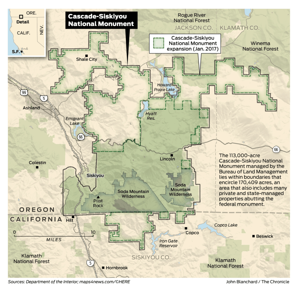
A federal judge’s ruling that 40,000 acres of former Oregon & California Railroad lands in the Cascade-Siskiyou National Monument must remain in timber production is far from the last word on this question, and even if it is eventually upheld, it would affect only a portion of monument land and perhaps much less than the 40,000 acres in the ruling.

Judge Richard Leon of the U.S. District Court in Washington, D.C., ruled in a case filed by the American Forest Resource Council, a timber industry group. The AFRC argued that the expansion of the monument declared by President Barack Obama in 2017 improperly overturned the intent of Congress when it passed the O&C Act in 1937, designating more than 2 million acres of forest in 18 Western Oregon counties for sustainable timber production. Congress had granted title to the lands in 1866 to the railroad company as incentive to complete the Oregon portion of the Portland to San Francisco railroad. When the company failed to sell the land to settlers as required, Congress took it back in 1916, and added more acres from a similar land grant in 1919. The O&C Act placed all those lands under the jurisdiction of the Interior Department to be managed by the Bureau of Land Management for permanent forest production.

This E&E News story is also interesting with more legal details..

Here’s AFRC’s side of the story (from their newsletter):
In late 2019, the U.S. District Court in Washington D.C. issued favorable rulings in two major cases enforcing the O&C Act. (October and November 2019 newsletters). The Swanson III case seeks to
require BLM to offer its declared allowable sale quantity (ASQ) each year, which is one of the mandates of the O&C Act. The other case involves challenges led by AFRC and the Association of O&C Counties to the 2016 Resource Management Plans (RMPs) for western Oregon BLM lands.

Judge Leon ruled in September, “Every year, BLM is required to sell or offer for sale an amount of timber that is not less than the declared annual sustained yield capacity of the timberland subject to the O&C Act.” He also found that “the record establishes that BLM has repeatedly failed to comply with the O&C Act’s timber sale mandate.” In November, he ruled that the 2016 RMPs violated the O&C Act’s mandate that all O&C timberlands “shall be managed” for “permanent forest production” under sustained yield principles. This is because the RMPs set aside 80% of the land base into “reserves” where harvest is severely curtailed.

The court instructed the parties to file proposals in these cases as to the appropriate remedy, which were submitted on January 27. The plaintiffs’ proposal, incorporating both Swanson III and the RMP challenges, involves preparation of an amended or revised plan, an ongoing requirement to sell the ASQ, and interim direction on volume while the plan is being reviewed. The government’s proposals ask in large part for the Court to return BLM to an open-ended administrative process while keeping the existing plans in place. Response briefs will be filed in late February and a final order could be issued any time after that.

In the November ruling, Judge Leon also invalidated President Obama’s expansion of the Cascade Siskiyou National Monument that encompassed about 40,000 acres of O&C lands. Both the government
and intervening environmental groups have appealed the ruling to the U.S. Court of Appeals for the District of Columbia Circuit, also called the “D.C. Circuit.” Resolution of the appeal is likely to take at least 12-15 months.

Does anyone know why the “government” chose to appeal the decision?

How Does a Decision-maker Know What’s “Right”? Guest Post by Jim Furnish

Thanks to Jim Furnish’s for his take on “what makes a land management decision right?” (Others are welcome to submit posts on this topic).

This poses THE trenchant question when working one’s way through a controversy. The very existence of controversy indicates opposition, unease, and concern about the status quo or new proposal. The science and art of finding the most elegant solution is the responsibility of decision-makers, but “right” decisions can prove elusive. Good leaders excel here; poor ones flounder. Difficulty increases because outcomes often remain unknown for some time, meaning that knowing what’s right at decision time may be impossible. I’ll share what worked for me, acknowledging that one has to tailor their decision-making methods to their own skills and character.
Before proceeding, let me address what I consider to be an oft-stated but errant myth: “good decisions leave all parties of a conflict equally upset.” In my experience, this became almost dogma as I heard many decision-makers explain their rationale for a course of action, thinking that the right decision necessarily lay in a brokered middle ground that left both sides angered and neither whole. I find this notion confounding. A right decision should incorporate as much common ground as possible, leaving both sides feeling they achieved important aims; “win-win”, to echo a trite saying.

Realistically, this is often not possible. Which leads to another common brokering concept: what can all sides “live with”? This suggests optimality. It has a positive feel, but this hints at settling for some least offensive solution. It also reflects a social construct, neglecting an all-important priority — does the decision do right by the land?
I consider the land ethic issue to be the essential element of right decisions for natural resource managers. This may not factor in decisions for a banker or insurance manager, but must be a priority if one is managing land. In my view, this was the essence of my national forest business. Here I give some deference (not much) to private land managers for whom economics and profits play a more prominent role, but for public lands I think a bias for environmental considerations exists, or should.

Why? Public lands must be managed to benefit the citizenry, and this basic stewardship responsibility underpins all decisions. Commercial transactions commonly involve forest products, ski areas, grazing, and concessions among others, and private entities naturally focus on their bottom line. I never considered it my responsibility to assure the financial health of a business contractor. But if my decision did not focus primarily on the environmental effects of commercial entities doing business on public land – in my role as steward – who would see to it? I think “citizen owners” of public land have every right to expect and demand this of public land managers.

How to apply this in trying to reach a right decision? Context matters. As an example, consider ATV use, a heated issue since ATVs burst on the recreation scene about the 1980s. Most agencies found themselves caught flat-footed as ATV users exploited a cheap, fast, and nimble ride to essentially replace 4WD vehicles. New trails laced forest and alpine, and solitude disappeared. How does one find the right balance between exclusion and permission? Do users have an inherent right to go virtually anywhere outside Wilderness areas?

I begin with the adage “just because you can doesn’t mean you should”. The FS took an important, long overdue step about 2005 by requiring that ATVs stay on designated routes, to be determined by comprehensive travel plans. A major issue was whether illegally created ATV trails could or should become a designated route. The FS left that door open to be determined locally. The battle was on. Enviros pushed for minimal routes and large scale exclusion zones. ATVers wanted almost every existing track to become a designated route. I slide toward the enviro end in seeking the right balance on that spectrum.

I try to simplify an arguably complex issue by asserting that ATV use is capable of significant soil and water damage, wildlife impacts, noise, and loss of solitude. ATV use is legitimate but needs restrictions as per Nixon’s Executive Order 11644. Accordingly, ATV use is permissible after negative effects are minimized and/or mitigated. Environmental issues as well as effects on other users must be accounted for. This means that ATV users should get the short(er) end of the stick. All things considered, this is not unfair and it’s “right” in my book.
I think historic context is crucial in working through other conflicts like logging and grazing. Timber industry had it their way for decades until the spotted owl solution in the Pacific Northwest came down heavily in favor of wildlife habitat and fish protections. The agencies doled out pain unequally; again, right in my view. Similarly, ranchers historically received preferential treatment and federal grazing has been supported at well below market value for decades. This context should tilt “right decisions” toward an environmental bias to help restore balance, especially when necessary to restore degraded environments.

Ultimately, I tried to weigh all factors in reaching a just outcome, but this didn’t mean I tried to make everything equal. Strive to help all sides to an issue achieve their aims, but it’s often necessary to take from one side to give to another in reaching a right decision.

Climate Science Voyage of Discovery. III. History of the RCP 8.5 Controversy

Steve Wilent pointed our attention to what is known as the 8.5/BAU (does RCP 8.5 represent Business as Usual, as many scientific papers say?) controversy a while back. I thought I’d post this Twitter roll (hopefully you can click to it) by Oliver Geden because it includes the sociology of science perspective. so often missing from climate science discussions. Also it seems like a gradual introduction to acronyms, and has links to many other papers of interest.

If you have trouble following the Thread reader, please let me know.

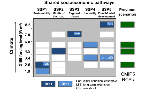
What is a Representative Concentration Pathway? You can read definitions, which aren’t necessarily very helpful. I like this article by Zeke Haufather because it tells the story of how the RCP’s were developed and used, leading to:

However, its position as the only non-mitigation scenario considered in the IPCC AR5 along with relatively poor communication between energy modelling and climate modelling communities led to a widespread misperception both in the media and in the academic literature that RCP8.5 was the expected “business as usual” outcome in a world without any future climate policy.

While worst-case outcomes are important to take into account, particularly given the uncertainties in the magnitude of carbon cycle feedbacks, it is important that they not be considered in isolation. Taking the range of possible baseline outcomes from 6.0 to 8.5 W/m2 forcing would provide a more realistic set of scenarios for studying climate impacts in a no-policy future.

On the other hand, though, if models and scenarios estimate so many things, how can we be sure that their estimates are accurate? From the Ritchie paper:

This paper finds climate change scenarios anticipate a transition toward coal because of systematic errors in fossil production outlooks based on total geologic assessments like the LBE model. Such blind spots have distorted uncertainty ranges for long-run primary energy since the 1970s and continue to influence the levels of future climate change selected for the SSP-RCP scenario framework. Accounting for this bias indicates RCP8.5 and other ‘business-as-usual scenarios’ consistent with high CO2 forcing from vast future coal combustion are exceptionally unlikely. Therefore, SSP5-RCP8.5 should not be a priority for future scientific research or a benchmark for policy studies.

It’s also clear that “poor communication” between energy modelling and climate modelling communities and the difficulty of communicating what they are doing to other scientific communities, including the impacts folks, as well as the media, may be a real problem.

Geden also refers to the BECCS debate, which seems to me another discipline gap – modelers are going to assume BECCS but there is no link to people who might say it’s feasible or not in a particular place (Geden’s slide 6). When he says “the STS community will have a field day.” He means the science and technology studies community, who study, among other things, how people and groups work to produce knowledge.

Roger Pielke, Jr. tied this back to the discipline of scenario planning in his article here.

Scenarios of the future have long sat at the center of discussions of climate science, impacts and adaptation and mitigation policies. Scenario planning has a long history and can be traced to the RAND Corporation during World War 2 and, later (ironically enough) Shell, a fossil fuel company. Scenarios are not intended to be forecasts of the future, but rather to serve as an alternative to forecasting. Scenarios provide a description of possible futures contingent upon various factors, only some of which might be under the control of decision makers.

The climate community got off track by forgetting the distinction between using scenarios as an exploratory tool for developing and evaluating policy options, and using scenarios as forecasts of where the world is headed.

To summarize there are three separate ideas. 1. RCP 8.5 was never feasible, as it relied on using a great deal more coal that (other scientists think) doesn’t exist. 2. Lotsa coal is not business as usual. 3. the RCPs are scenarios and are not comparable to each other.
As I recall, the idea of scenario planning was to look at a broad range of futures without likelihoods and pick things to do that make sense under a range of scenarios. Not to pick the worst ones and model the extent of further bad things. Let’s do an example. Denver Water used to do scenario planning. Suppose they had a most extreme scenario- climate change dries up supply and the population grows. What to do? The point is to think about it. Not to model and write news stories about how we won’t have any water. It’s really about what you do with the info of “what could possibly happem” not how you derive it, nor to what detail.

BLM Move and the ‘deconstruction of the administrative state’

High Country News has an article of interest:

Observe the BLM’s displacement

Moving land-management HQ out of Washington illustrates the ‘deconstruction of the administrative state.’

We’ve discussed this issue here and elsewhere. Aside from the machinations of the Trump administration, can a case be made that it is better for a land-management agency to be physically closer to the land it manages? For example, the USFS’s Region 5 office in Vallejo, Calif., seems out of place near SF Bay and far from any national forest. Sacramento would have been ideal, as it is closer to the forests and to the state government. Yes, it is crucial for BLM and USFS to have a presence in D.C., but not all national staff needs to be there. A colleague once suggested that much of the USFS staff could work well if distributed around the regional offices. Likewise, many regional office staffers could work from national forest HQs.

Grand Canyon development proposal resurfaces on the Kaibab

We’ve discussed the use of land exchanges that would facilitate the growth of urban areas by giving them more private land in logical growth areas using the example of Las Vegas.  At a different scale, the town of Tusayan appears to be an inholding in the Kaibab National Forest, which limits its growth opportunities.  They have been looking at a proposal to develop a nearby separate inholding (which the town owns a part of).   It would require a special use permit to for roads and utilities to cross national forest lands.  It has been controversial (attracting unwanted attention according to the town; the 2nd Twitter link works), and the town has just approved a revised proposal, which will be submitted to the Forest Service.  The Kaibab National Forest rejected the last proposal in 2016 as inconsistent with the requirements for a special use permit.  Here is a part of the rationale that relates to the forest plan:

CFR 251.54(e)(l)(ii) requires that the proposed use must be consistent, or can be made consistent, with the Kaibab Forest Plan. The Forest Plan envisions management at a landscape­ scale by taking an “all-lands approach,” and specifies strategies to achieve the desired conditions and objectives in the Plan, including working closely with partners and across administrative boundaries to meet common objectives. The development that would be enabled by authorization of the proposed use of NFS lands could substantially and adversely affect Tribal lands and the Grand Canyon National Park.

36 CFR 251.54(e)(l)(v) provides that the proposed use must not unreasonably interfere with the use of adjacent non-National Forest System lands. The FS received written comments from the National Park Service (NPS) through the Principal Deputy Assistant Secretary of the Interior for Fish Wildlife and Parks which pointed out that potential impacts to the Outstanding Universal Value of the Grand Canyon National Park (GCNP), either from the roads that would be authorized by easement or the reasonably foreseeable development on the two private properties that would be enabled by the roads and other facilities, are of concern. The GCNP also raised concerns in a meeting regarding impacts on infrastructure that they share with the Town of Tusayan. The NPS was concerned that any activity that would result in significant increases in visitation or occupation near the Park would affect the Park’s capacity to absorb the additional use.

The first rationale is an interesting “all-lands” interpretation of its forest plan to encompass the objectives of the National Park Service and tribal lands.  The second rationale stands on its own, but it also explains what those interests are.  It’s not obvious that the recent modifications in the proposal are going to address these concerns, so I expect we’ll be seeing more about this.  (Here is the CBD take on the original proposal.)

Investigation: Ferry County, WA range riders were in Spokane shopping when they were supposed to be patrolling

The Spokesman Review has the full story, which involves range-riding (or the lack thereof) in northeastern Washington, including on the Colville National Forest.

———–

Two range riders who were supposed to be protecting cattle in Ferry County in 2018 were more than 100 miles away in Spokane, shopping and spending time at the Davenport Hotel, according to a Washington Department of Fish and Wildlife investigation that has since been referred to a Thurston County prosecutor.

Meanwhile, environmental groups charge, wolves killed cattle in the area the range riders were supposed to be patrolling, which led in turn to the wolves being exterminated.

As for the range riders themselves, one of them denied in a Friday interview that they neglected their duties at all.

The allegations and denials are the latest chapter in a long and tense saga between those who graze cattle on public lands in Washington and those who support the return of wolves to the area.

The Washington Department of Fish and Wildlife is recommending second -degree theft charges be filed against several contract employees tasked with keeping wolves from killing cattle in northeast Washington.

While the amount of money allegedly stolen is small, the investigation highlights the need for stricter oversight of the state’s range riding program and undermines WDFW’s rationale for killing wolves in some cases, said Chris Bachman, the wildlife program manager at the Spokane-based Lands Council….

At its core, the investigation highlights the challenges facing the coexistence of cattle and wolves in the West’s second most populous state.

Each spring, ranchers in northeast Washington send their cattle into the steep and thickly treed Colville National Forest, where most of the state’s more than 120 wolves roam. In a predator-free landscape this was a tenable situation. But since wolves returned to the state in 2008, they have killed cattle each year.

And because of the area’s topography, many traditional nonlethal deterrents – pastures, dogs, lights and colored flags tied to fences – don’t work well. Instead, range riding is widely seen as the most effective nonlethal deterrent.

It’s also the hardest to quantify or manage, even if the idea behind it is simple and ancient: consistent human presence keeps wolves away. In practice, that means riders often spend days or weeks in the woods, out of cell reception. What’s more, riders need to know how wolves and cattle behave, while simultaneously having the skills to live in the woods, ride horses, fix ATVs and more.

It’s a job that is not conducive to timecards.

“There is an expertise there and most people who engage in range riding are not experts and need to be schooled and trained by those who do it professionally,” said wolf expert and advocate Carter Niemeyer in a previous interview with The Spokesman-Review. “Where it gets off to a bad start is there is a pot of money. … People come running and say, ‘How do I get some of it?’ ”

If the state’s investigation is correct, that’s what happened in the case of DS Ranch.

WDFW detective Lenny Hahn first started investigating the DS Ranch on Oct. 15, 2018. At that time, the contract was valued at $352,000 and listed seven different people, including Jolene and Arron Scotten and several of their relatives, some of whom lived together.

According to cell phone records obtained via a search warrant, there were numerous times Scotten and his wife said they were working when they were not. Some of those periods aligned with times when wolves attacked cattle.

And this is where, according to Bachman and several other pro-wolf organizations that provided the records to The Spokesman-Review, the Scottens’ deception cost the state more than just money.

Washington’s lethal removal policy allows for the killing of wolves if they kill or injure livestock three times in a 30-day period or four times in a 10-month period – but only if two nonlethal deterrents have already been deployed.

On Sept. 12, 2018, WDFW announced the planned killing of members of the Old Profanity Territory (OPT) wolf pack after repeated attacks on cattle. According to a news release, the livestock producer had used several nonlethal deterrents, including range riding, calving outside of the wolf pack’s range, delaying the turnout of calves until they were larger (and harder to kill), removing livestock carcasses, and removing sick and injured livestock.

According to WDFW documents, justifying the need to kill some OPT wolves was made partly on the assumption of heavy range rider presence .

Meanwhile, the investigation alleges Scotten and his wife, who rode primarily in the OPT pack area for the Diamond M Ranch, were not working when they said they were.

For instance, on Sept. 4 and 5, 2018, Scotten claimed to have worked a combined 25 hours. But he was actually in Spokane buying building supplies from Ziggy’s Building Materials for a portion of that time, according to the WDFW investigation. During that same two-day stretch, the OPT pack injured two calves and killed one calf.

Just days later, on Sept. 12, WDFW Director Kelly Susewind authorized the killing of members of the OPT pack in response to repeated attacks on cattle.

Six days after WDFW approved lethal removal, Scotten claimed to have worked seven hours. However, according to the investigation, he was in Spokane staying the night at the Davenport Hotel on Sept. 18 and 19. Jolene Scotten also claimed to have worked eight hours on Sept. 19, while phone records place her in Spokane, according to the investigation.

On Sept. 21, WDFW confirmed the OPT pack attacked and injured five calves.

Meanwhile, some at WDFW were questioning the range riding efforts in the area.

“WDFW had concerns with documenting the work by range riders, as staff had not seen the range riders during most field checks or on most trail camera photos,” states a letter sent from a Ferry County WDFW staff member to WDFW’s Region 1 director on Oct. 25, 2018.

The next day, WDFW authorized another round of lethal removal.

In fact, out of 440 15-second videos taken by WDFW trail cameras in the OPT pack area throughout September and October, riders with DS Ranch were only spotted four times.

Those concerns persisted. In notes from a call in July 2019 discussing the OPT pack, employees in the district questioned whether “actual range riding, not just driving on the road” had ever taken place.

“Have never had actual, quality range riding on this landscape,” the notes state. “Daily patrols aren’t doing much.”

Groups threaten to sue for wolverine protections

Greenwire today: “Groups threaten to sue for wolverine protections.” Excerpt:

Wolverines are the largest members of the weasel family, but they look more like small bears with bushy tails. Conservation groups say the animals need to be listed as threatened under the Endangered Species Act.

Ten groups want to force the federal government to protect the elusive wolverines.

The groups estimate there are around 300 wolverines left, sparsely scattered across the Mountain West, including Idaho, Washington and Oregon. Their young depend on snowy, high-altitude habitat that could disappear as the climate warms.

Gary Macfarlane is with the advocacy group Friends of the Clearwater, which signed on to sue federal agencies if they don’t add wolverines to the endangered species list in 60 days. The notice of intent to sue includes 10 groups.

The article cites winter recreation (esp. snowmobiles) as a factor. But if climate is the main factor in a Wolverine decline, there isn’t much the agencies can do about it, except to protect habitat as warming progresses.


Should Timber Industry Workers Help the Forest Service Pick Trees for Helicopter Logging in Alaska?

The Center for Western Priorities has a great newsfeed, but sometimes you have to look past their anti-Interior bias. For example, this morning they posted this..
“Logging gets priority in Trump’s Interior Department” where they blended the wildfire carbon kerfuffle Matthew linked to here with an Alaska logging project.

CWP says “The Interior Department’s attempts to help the timber industry don’t stop there. Newly released documents show the administration has partnered with the state of Alaska and the timber industry there, paying $300,000 annually for five years so that industry can pick which trees should be cut in an upcoming sale in the Tongass National Forest.”

Oh, well. They linked to this WaPo story. Given the need to fit the Dominant WaPo Narrative, I thought the writers did a good job of explaining both sides and picking people to ask questions who are directly involved. I also think the old-timer, passing on skills angle is interesting- perhaps Alaskans on TSW can enlighten us more about this?

1. Earthjustice attorney doesn’t like industry picking trees.
2. State forester tries to place the Trump factor in context of the longer term decision making process and points out that FS staff are there in the units also.
3. Sitka Conservation Society understands need for industry to be involved, and also wants the public more involved in decisions.

Earthjustice staff attorney Tom Waldo said in an interview that federal experts — not the logging industry itself — should identify the trees, since they are charged with balancing the forest’s commercial appeal with protecting its overall health and the species within it. Earthjustice, which is challenging the sale on the grounds that the Forest Service has failed to fully inform the public about it, obtained the documents through a Freedom of Information Act and provided them to the Energy 202.

“Here they’re vesting a really lot of power in the hands of someone with a very specific interest in the timber,” Waldo said. “The very best trees for logging are also the best trees for wildlife habitat.”

But Alaska State Forester John “Chris” Maisch said in an email that the logging site was selected during the Obama administration, underwent extensive environmental review and any final decisions are made by government officials. The Forest Service staff lacks the expertise to pick the trees that are both commercially appealing and can be safely felled and lifted via helicopter, he said.

Industry foresters are working with Forest Service staff “in the units and are not doing this work independently.” Maisch said.

“It’s a team effort with experienced foresters passing this skill set to the next generation,” he said, adding that protections are put in place if trees with bird nests “or other sensitive habitat is identified.”

Andrew Thoms, executive director of the Sitka Conservation Society, said it is understandable that the Forest Service wants to tap the expertise of those in the private sector. “The only people who know how to pick out these trees are the old timers.”

But he added that it is crucial to involve the public in these decisions, especially since the most massive cedar and spruce trees in the Tongass stand the best chance of propagating their species. “You want them to put out seeds, because there’s a reason they’re a thousand years old.”

Both-Sides Reporting on New Clean Water Act Rule- Let’s Collect Them!

Navigable waters? What would EPA have decided?

While the Clean Water Act isn’t usually part of our TSW portfolio, since Matthew brought it up here (and see other stories brought up by Brian Hawthorne here in the comments as well as some legal history by Kevin Turnblom here. I’d be interested in what your local papers have to say about it, or whether they use the AP story.

The AP story here started off with ..

“WASHINGTON (AP) — The Trump administration on Thursday ended federal protection for many of the nation’s millions of miles of streams, arroyos and wetlands, a sweeping environmental rollback that could leave the waterways more vulnerable to pollution from development, industry and farms.”

As Kevin Turnblom pointed out, If a judge throws a rule out because it’s illegal, and a reg is never enforced (so nothing has ever been protected by it) then.. is the next one really a “rollback”? It’s clearly not a rollback in Physical World (where water exists).

I did run across a story in the Colorado Springs Gazette by Tom Roeder that tried to show both sides and also gave some local context.. here’s a link and below are some excerpts.

Under the old rule, enacted by the Obama administration in 2015, federal authorities took a broad, and some say nebulous, view of their powers to stop water pollution.

The 2015 rule enforced federal regulation on “intrastate lakes, rivers, streams (including intermittent streams), mudflats, sandflats, wetlands, sloughs, prairie potholes, wet meadows, playa lakes, or natural ponds.”

The Obama-era rule covered an estimated 60 percent of U.S. waters.

That meant actions that could impact those waters required a federal permit. The rules prompted a string of court battles, and even the Supreme Court called defining which waters were federal “a contentious and difficult task.”

The lawsuits meant the Obama-era rules never took full effect, and left the EPA scrambling for a definition of federal waters that would pass judicial muster.

President Donald Trump made rolling back the water regulation a plank in his 2016 campaign as he wooed farmers and ranchers.

But the rollback took years as the EPA wrangled over rules and faced a firestorm from environmental groups.

You gotta love Colorado politics, though. Our governor, who seemingly would think that our state is capable of regulating water quality, especially since there is a D majority in the House and Senate said:

Colorado’s Democratic Gov. Jared Polis issued a scathing statement about the rule change.

“Our administration will continue to reject attempts by the Trump administration to gut proven ways to protect our health and environment,” he said.

How could it be a “proven” way if the reg had never been in force?

Meanwhile, both the Colorado Springs mayor and local Congressperson argue for not federalizing what needn’t be federalized.

Suthers said those waters that won’t be regulated by the feds will still have plenty of oversight, but from state and local authorities rather than the EPA.

“Anything that happens there will be in the jurisdiction of the state of Colorado,” said Suthers, who served as the state’s attorney general before winning the city’s top job.

Lamborn said having locals regulate more water issues is the best solution.

“If you believe in federalism, then units of government that are closer to the people should regulate those decisions,” he said.

Here’s another interesting statement from this piece:

I haven’t checked this for accuracy but the author says..(about the 2015 non-implemented rule).

EPA estimated that the final Clean Water Rule expanded the types of water subject to Clean Water Act jurisdiction by about 3 percent, or 1,500 acres nationwide. Opponents clearly think it could be much broader – and until they see the rule implemented on the landscape, their fears may have some basis in fact.

Meanwhile Matthew’s post headline said “millions of acres.” It might be interesting for someone to go back and check the 2015 regulation. The difference might well be in assumptions about how it might have been interpreted, which we never found out because it wasn’t ever implemented.

Here’s the American Farm Bureau’s side of the story:

The 2015 rule grants the federal government regulatory control over virtually any waters – and many land areas that only temporarily hold water – assuming a scope of authority Congress never authorized. It effectively eliminates any constraints the term “navigable” previously imposed on the agencies’ Clean Water Act jurisdiction, and few, if any, waters would fall outside of federal control.

The 2015 rule provides none of the clarity and certainty it promised. Instead, it creates confusion and risk by giving the agencies almost unlimited authority to regulate, at their discretion, any low spot where rainwater collects, including common farm ditches, ephemeral drainages, agricultural ponds and isolated wetlands found in and near farms and ranches across the nation, no matter how small or seemingly unconnected they may be to true “navigable waters.”

The 2015 rule defines terms such as “tributary” and “adjacent” in ways that make it impossible for farmers and ranchers to know whether the specific ditches, ephemeral drains or low areas on their land will be deemed “waters of the U.S.” But these definitions are broad enough to give regulators (and citizen plaintiffs) justification to assert that such areas are subject to Clean Water Act regulation and give the agencies sweeping new authority to regulate land use, which they may exercise at will, or at the whim of a citizen plaintiff.