Yes, Virginia, Political Appointees Do Meet With Interest Groups: The Importance of Context in News Stories

Secretary Zinke meets with
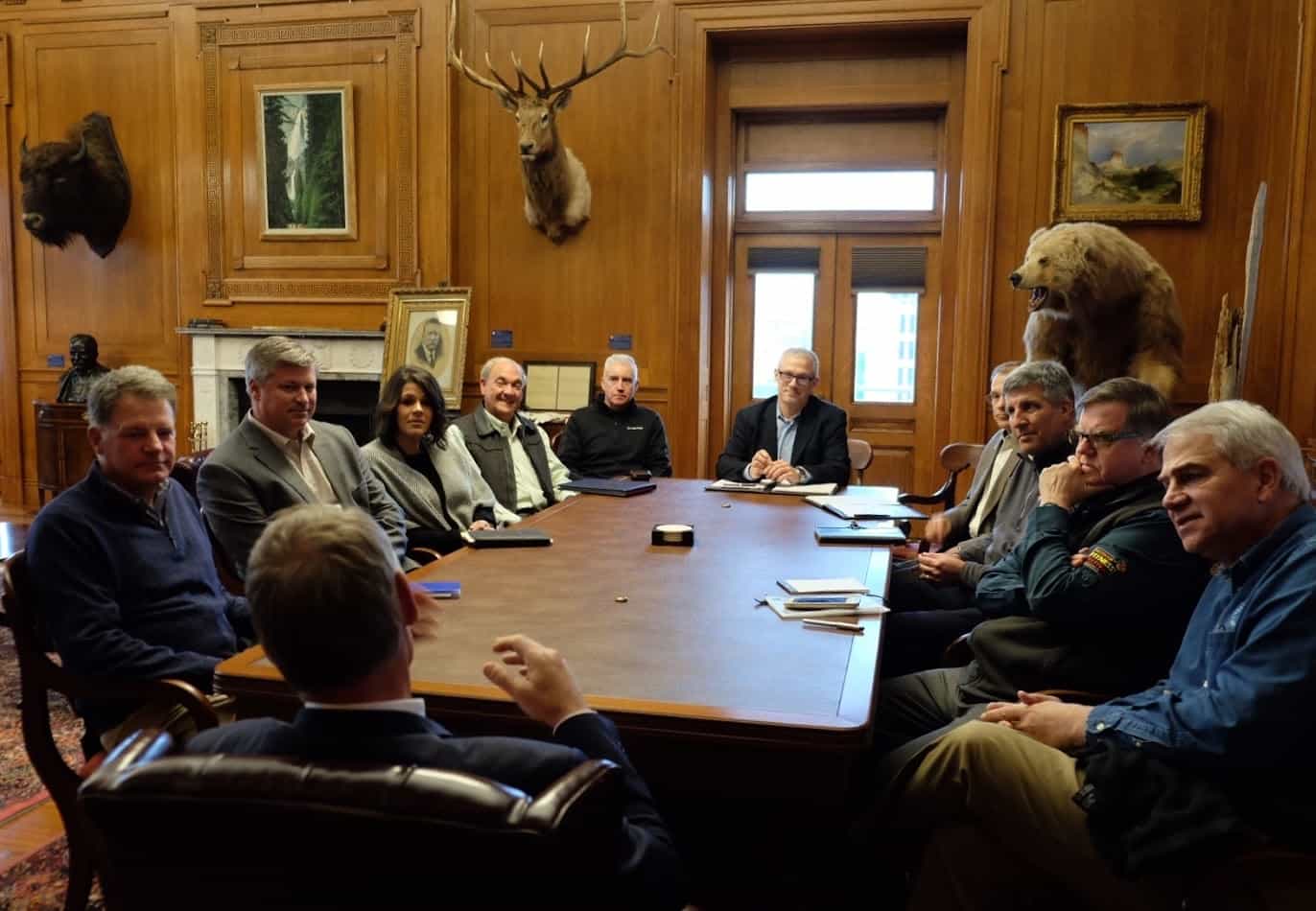
Outdoor Recreation Industry Roundtable (ORIR)
Photo credit: Tami Heilemann

Ruben Navarrette, a syndicated columnist who shows up in the Colorado Springs Gazette op-ed page, recently wrote a column in which he talks about the importance of context in news stories. I like to think of news stories as newborn babies, and the work of NCFP regulars as wrapping the stories in a warm, fluffy blanket of context. Navarette gives some examples and concludes:

Context changes a minor story from what one president is doing wrong into a major story about what’s wrong with our political system.

What he is saying is that our fluffy blankets of context can add not only to fairness and accuracy, but ultimately also to framing problems differently. Here’s an easy example from our own subject area.

This is from Greenwire via the Society for Environmental Journalism here.

“Andrew Wheeler met with a range of companies and trade groups with interests before EPA after he took charge at the agency….

Wheeler was scheduled to call or meet with executives for the American Fuel and Petrochemical Manufacturers, BP America, Delta Air Lines and Valero Energy Corp. during that month, according to the document. In addition, he was slated to take meetings with agricultural interests, like the American Soybean Association and CropLife America.”

Wheeler met with groups with “interests before EPA”. Oh my goodness. This news story seems to assume that the best regulation is done without speaking to the regulated about their views and concerns. Logically, then Secretaries of the Interior should not meet with members of the Outdoor Recreation Industry? If, on the other hand, we want to add context, as Navarrette suggests, to “what’s wrong with the political system” we can look across administrations, and also in the eyes of state and local government officials.

Here’s a link to quotes from a letter by former Wyoming Governor Dave Freudenthal (D), of Wyoming, to then Secretary of the Interior Salazar about changes in oil and gas regulations.

“I appreciate your stated intentions to restore balance to the leasing program. Unfortunately the proposed changes potentially hand significant control over oil and gas exploration, development and production to the whims of those that profess a ‘nowhere, not ever’ philosophy to surface disturbance of any kind,” Freudenthal wrote Salazar on Jan. 8.

“I have always been a strong proponent of balance” but “Washington…seems to go from pillar to post to placate what is perceived as a key constituency. I only half-heartedly joke with those in industry that, during the prior administration, their names were chiseled above the chairs outside the Office of the Assistant Secretary for Lands and Minerals. With the changes announced [by Interior earlier this month] I fear that we are merely swapping the names above those same chairs [with] environmental interests, giving them a stranglehold on an already cumbersome process,” Freudenthal said.

Freudenthal seems to wonder whether citizens are well-served by disruptive flip flops on policy associated with administrations who change the advisory input from “lots of x” to “never, nohow, no way x” based on listening predominantly to one set of interest groups. The impacted states might prefer a more pragmatic and less ideological middle path, with a focus on reducing impacts rather than removing industry. They were good questions in 2010, IMHO, and remain good questions today.

What Works to Contain Wildfires? A Bottom-up Study from Down Under

Figure 3 from the Collins et al. paper.

This study looks at wildfires from the ground up rather than from the satellite down, as the previous post. Many studies and news articles seem to make the connection “climate change (via heat and drought) will lead to worse fires (I think they mean or imply “worse in terms of damage to things important to humans”).” What stands between weather and damage are a) fuel treatments, suppression folks and their technology, tactics and strategies, and b) peoples’ behavior in terms of developing fire resilient communities, including evacuation technologies and so on. This study looks specifically at many of the variables related to a), and how they interact to contain wildfires. The study is from New South Wales, Australia. I wonder whether readers with experience in the US find that these observations match up with their own experiences?

In order to understand the landscape of the different scientific approaches used in the studies of wildfire, I think it’s helpful to specify the questions asked and the methods used.

Question Asked:

Specifically, we asked what is the relative importance of environmental and human factors in containing grass and forest fires at various time periods from when the first ground crews arrived at the fire. From the findings of previous studies, we hypothesise that:
1. Factors which influence fire behaviour – fuel, weather and topography – will be important in determining the probability of containment.
2. The number of resources and the response time will be important in determining the probability of containment.

Research Methods Data from 2219 forest fires and 4618 grass fires. “Random forest” (from machine learning?) approach.
Who Did the Study? Who Funded It? Scientists from Australian universities. It does not appear to have been funded by anyone.

Here are some paragraphs from the discussion.

Unsurprisingly, the more resources available to control the fire, the more likely the fire will be contained. Grass fires are generally easily accessible to tankers and containment is achieved by directly applying water to the fire edge. If the fire spread is too fast or the flame height too high, then direct attack is made on the flanks of the fire, working from the rear to the head (Cheney and Sullivan, 2008; Luke and McArthur, 1978). The more resources available, the faster the fire will be contained. Forest fires may be directly attacked at the fire edge if it is safe and accessible to firefighters or contained by indirect attack which involves burning back from control lines to provide an effective barrier against the main fire (Fried and Fried, 1996; Luke and McArthur, 1978).

Indirect attack cannot be achieved unless a suitable control line is established, hence the more crews available to prepare the control line and ensure the back burn is contained within the control line, the faster the fire will be contained. Fires are successfully contained when the fire spread has been stopped, therefore factors which influence fire spread, fuel load, weather conditions and topography (Cruz et al., 2015) are also important factors influencing fire containment. Our results align with Tolhurst and McCarthy (2016) who characterised fires burning when the fire danger index<50 as mostly fuel- and topography-dominated fires and fires burning when the fire danger ndex > 50 as mostly weather-dominated fires. In our study, fuel and topography were the dominant environmental variables in forest models with weather less important. However in our study, most (97%) forest fires occurred when the fire danger index < 50. In New South Wales, a fire danger index>50 occurs on average only 1.9% days each year (calculated using 3pm weather data from the Bureau of Meteorology weather stations in NSW over a 30 year period from 1982 to 2013). Studies that focus on fires above FDI 50 find weather conditions are the strongest predictor of fire spread (e.g. Jin et al., 2014; Moritz et al., 2010; Price et al., 2015) and therefore we may expect suppression effectiveness to be more strongly linked to fire weather in these conditions.

.

Collins2018_suppression is a link to the entire study.

9th Circuit Voids Four Timber Sales on Alaskan Tongass National Forest

As was pointed out in this post, the 9th Circuit Court of Appeals has invalidated four U.S. Forest Service (USFS) logging projects on the Tongass National Forest in Alaska, which would have clearcut 1,700 acres of old-growth rainforest and constructed about 14 miles of logging roads.

Jon and Andy have shared additional information about this issue over here, so please check that out.

Below is a press release I got from Larry Edwards of Greenpeace. A copy of the ruling is here.

ANCHORAGE – A unanimous verdict of the 9th Circuit Court of Appeals has invalidated four U.S. Forest Service (USFS) logging projects in Alaska’s Tongass National Forest, the nation’s largest national forest, ending a ten year legal battle. Greenpeace USA and Cascadia Wildlands filed the suit in 2008.

The decision permanently stops four timber sales that would have clearcut 1,700 acres of old-growth rainforest — habitat that is critical to deer, which are the primary prey of the rare Alexander Archipelago wolf (or “Islands Wolf”), and vital to subsistence hunters. The lawsuit focused on all three — deer, wolves, and hunters.

“But the victory is for more than deer, wolves and hunters,” said Larry Edwards, a representative of Greenpeace and resident of Sitka, Alaska. “It also protects many other kinds of wildlife in those areas, diverse forest uses, and carbon that is stored in the soil, trees and vegetation. As a far-north coastal rainforest, fires are rare and very small here, and as a result the Tongass is world-renown for storing carbon in its soil, trees and vegetation.”
At issue in the litigation was how the Forest Service determined impacts of the logging projects on Sitka black-tailed deer, and consequently wolves and hunters.

The Court concluded that the agency’s modeling of deer winter habitat “does not accurately measure forest structure [and] was too unreliable to be used.” It also said the “USFS failed to explain why it was authorizing the projects despite lower-than-recommended deer habitat capabilities.” (The recommended minimum capability is specified in the Tongass Forest Plan.)
In voiding the agency’s approvals of its four projects, the court noted that in “over a decade of litigation … USFS has been given multiple opportunities to correct flaws in its project analysis and ignored the court’s guidance.”

“The Forest Service was handed a clear message today that it cannot fudge the science in order to give its projects an ‘easy pass’ and sell excessive amounts of timber from a planning area,” said Chris Winter of Crag Law Center, one of the plaintiffs’ attorneys. “The Islands Wolf is a rare species in Alaska’s rainforest, and it’s vital that the agency follow the best science on how to protect it and how to provide for the needs of deer hunters.”
“The Forest Service has scheduled two of the projects in our lawsuit to be logged in 2019. The court’s verdict invalidating the decisions comes just in time.” said Gabriel Scott of Cascadia Wildlands.

“The Forest Service greatly overestimated the habitat available for deer, and consequently underestimated the impacts of logging, not just in the four projects in this case but in every one of its timber project decisions made between 1996 and 2008,” Edwards said. “This justified logging which should never have happened. Greenpeace and Cascadia have demonstrated, with the agency’s own documents, that its computer models were flawed. For recent projects the USFS has corrected those errors, but it refused to do so for the earlier ones,” he said.

Together, the four projects would have cut 33 million board feet of timber from 1,700 acres of old-growth forest, and about 14 miles of logging roads would have been constructed.

Attorneys representing the plaintiffs were Chris Winter and Oliver Stiefel of Crag Law Center based in Portland, Oregon, and Rene Voss of Mill Valley, Ca. Plaintiffs are grateful to the McIntosh Foundation for supporting the Islands Wolf litigation, from the beginning.

A Satellite View of Wildfires Since the 50’s

In this map, wildfires are shown in orange. Private lands are shown in purple while public lands are clear (no color). From Earth Matters.

I ran across this interesting approach to western fires from NASA. Followers of this blog have read the fire observations of folks like Leiburg in the teens, in which the Native American burning patterns were still visible. Then came big fires and fire suppression efforts, and since 1950 many changes in forest and fire management, invasive species, people living in the forest, people igniting the forest and so on. So to me, anyway, picking the dates 50 til present is within that larger dynamic and understanding the larger dynamic could explain some of the observations.
Data sources for the study are given at the end of the article.

1. There are more fires.
Over the past six decades, there has been a steady increase in the number of fires in the western U.S. In fact, the majority of western fires—61 percent—have occurred since 2000 (shown in the graph below).

(I think we’ve talked about the historic fire databases before.)

2. And those fires are larger.
Those fires are also burning more acres of land. The average annual amount of acres burned has been steadily increasing since 1950. The number of megafires—fires that burn more than 100,000 acres (156 square miles)—has increased in the past two decades. In fact, no documented megafires occurred before 1970.

(This is interesting, even if only from 1950 to 1970. It’s not clear to me what the frequency is on the y axis of this graph).

3. A small percentage of the West has burned.

Even though fire frequency and size has increased, only a small percentage of western lands— 11 percent—has burned since 1950. In this map, wildfires are shown in orange. Private lands are shown in purple while public lands are clear (no color). The location of wildfires was random; that is, there was no bias toward fires affecting private or public land.

Keith Weber, a professor at Idaho State University who led the analysis, was surprised at the 11 percent figure. There’s no clear reason yet for why more of the region hasn’t burned. “Some of the 89% may not burn because it has low susceptibility—not dry enough or it has low fuel (vegetation),” said Weber. “Some areas may be really ripe for a fire, but they have not had an ignition source yet.”

(I’m not sure about the public vs private land maps here.. check out the San Joaquin Valley of California. Also not sure if Tribal lands are considered public or private).

4. The same areas keep burning.
How has only 11 percent of the west burned, yet the annual number of acres burned and the frequency of fire increased? It turns out that many fires are occurring in areas that have already experienced fires, known as burn-on-burn effects. About 3 percent—almost a third of the burned land—has seen repeated fire activity.

The map here shows the locations of repeated fire activity. While you can’t see it at this map’s resolution, some areas have experienced as many as 11 fires since 1950. In those areas, fires occurred about every seven years, said Weber, which is about the amount of time it takes for an ecosystem to build up enough vegetation to burn again.

(It would be interesting to know exactly where those are).

5. Recent fires are burning more coniferous forests than other types of landscape.
Since 2000, wildfires have shifted from burning shrub-lands to burning conifers. The Southern Rocky Mountains Ponderosa Pine Woodland landscape has experienced the most acres burned—more than 3 million.

(Again, this is very interesting but not clear on what it means. Certainly plenty of shrublands are still burning.)

6.Wildfires are going to have a big impact on our future.

Research suggests that global warming is predicted to increase the number of very large fires (more than 50,000 acres) in the western United States by the middle of the century (2041-2070).

The map below shows the projected increase in the number of “very large fire weeks”—periods where conditions will be conducive to very large fires—by mid-century (2041-2070) compared to the recent past (1971-2000). The projections are based on scenarios where carbon dioxide emissions continue to increase.

(This assumes that more bad fire weather=more bad fires. That’s not a bad assumption (projections of future weather changes based on unknown levels of carbon) but reasonable people could also include assumptions about improvements in firefighting, community resilience, warming causing plant life to grow more slowly and lead to lower fuel loadings at less density, and so on.). It’s a bit like predicting deaths from a disease without considering health care efforts.

NFS Litigation Weekly November 30, 2018

Forest Service summaries:  Litigation Weekly Nov 30

The district court upheld the Moose Creek Vegetation Project on the Helena-Lewis and Clark National Forest with respect to Healthy Forest Restoration Act compliance.  (D. Mont.)

  • Greenpeace v. Stewart

The Ninth Circuit Court of Appeals reversed the district court and the Forest Service on four timber sales on the Tongass National Forest because of flawed analysis of deer habitat.  (9th Cir.)

  • Quiet title claims

(New cases – no links.)  Five plaintiffs in different cases seek to quiet title regarding rights to irrigation diversion structures on the Sawtooth National Forest.  (D. Idaho)


BLOGGER’S BONUS

(There was no link provided by the Forest Service above, but the article I linked includes a link to the court decision.)  This is a case that has been litigated for “over a decade.”  The 9th Circuit stated, “USFS has been given multiple opportunities to correct flaws in its project analysis and has ignored this court’s guidance.”  I wanted to emphasize the holding on species viability (these are rare deer).  The deer model was flawed because it “was too unreliable to be used in conjunction with the proxy on proxy approach of ensuring species viability.” The court cited the precedent of Lands Council v. Powell from 2005: “Crucial to [the proxy on proxy] approach . . . is that the methodology for identifying the habitat proxy be sound.”  Since the coarse filter approach sanctioned by the 2012 Planning Rule uses habitat as a proxy for species viability, this will place a premium on demonstrating that coarse filter vegetation plan components will provide the ecological conditions needed for at-risk species.  Typical forest plan revision documentation does not seem to take this requirement to demonstrate the soundness of their methodologies very seriously (despite the requirement in 36 CFR §219.9(b)(1) to make this determination).

This is the final step in resolving a case that was begun in 2009 and led to injunctions against several timber sales on the Kootenai National Forest.  The Montana district court held that the Forest had complied with the requirements of the injunction for the Miller West Fisher Project, and it was therefore dissolved.  Plaintiffs conceded all points except one involving the Endangered Species Act – the need to analyze incidental take for grizzly bears that may be harmed outside of their recovery zone.  The Forest relied on the analysis of incidental take done for a grizzly bear access amendment that is now included in its revised forest plan.  The court upheld a “tiered” consultation process, where analysis at the forest plan level is sufficient for projects unless “proposed actions would result in adverse effects to grizzly bears that were not fully analyzed in the first-tier biological opinion (emphasis by the court).  In its concurrence that the project is not likely to adversely affect grizzly bears, the Fish and Wildlife Service determined that, “the proposed action is not likely to adversely affect the threatened grizzly bear in ways other than described in the2011 consultation on the Access Amendment”(emphasis by the court), and that analysis did not need to be repeated.  (D. Mont.)


Collaborative flops

Salmo-Priest Wilderness, Colville National Forest.

The Colville National Forest released a draft Record of Decision for its revised forest plan on September 8. During the planning process, a collaborative group, the Northeast Washington Forestry Coalition submitted a proposal to designate more than 200,000 acres of new wilderness, to be offset by increased logging on other parts of the Forest and building new trails for mountain bikers, motorcyclists and ATV riders, who would lose access to some trails if Congress approved new wilderness. The revised plan proposed by the Forest includes only 60,000 acres of wilderness recommendations.

I guess that’s good news if you think that local collaboratives have too much influence on national forest decisions and/or if you are a proponent of logging. But wait!  It turns out that the most influence was wielded by the local governments, and the local timber company isn’t happy about that.

Russ Vaagen, vice president of Vaagen Brothers Lumber Co. and NEWFC board president, formally objected to the draft plan in a Nov. 6 letter. In the letter, he said the Forest Service’s decision was “skewed” by special interest groups. “The Colville National Forest belongs to all citizens of Washington and the United States,” he wrote. “Ferry, Stevens and Pend Oreille county commissioners represent just a tiny fraction of these citizens.” Later in the letter he said it’s unavoidable that locals will have “personal, financial interests” in what happens to federal land, but that those interests should “have no bearing on federal land management issues.”

This sort of left my head spinning. Maybe it’s because they didn’t get the increased logging either (I don’t know if that’s true)? Or maybe it’s that the “collaborative” part should win out over merely “local.” Or did the “local” actually use an end-run to obtain a top-down approach from an administration hostile to new wilderness?

I’ll go out on a limb here and suggest that since decisions to designate wilderness are inherently and legally political, this may legitimize and enhance the value of a local collaborative approach. Of course all is not lost on the Colville; the collaborative approach could count for something when the collaborative makes an end-run around the Forest Service to obtain wilderness legislation, since it can undercut an agency position that the Forest Service is doing what the public wants.

In another wilderness squabble involving an end-run by local governments to reduce wilderness protection, three counties in Wyoming have chosen to bypass a statewide collaborative process and support federal legislation that would eliminate wilderness study areas without designating any new wilderness.

Titled the “Restoring Public Input and Access to Public Lands Act of 2018,” HR 6939 would remove wilderness study designation and associated protections from approximately 400,000 federal acres in Lincoln, Big Horn and Sweetwater counties (see the bill below). The three counties declined to participate in a years-long consensus-based investigation of the wildlands. Saying the wilderness-study designation “prevents access, locks up land and resources, restricts grazing rights, and hinders good rangeland and resource management,” Cheney introduced her measure Sept. 27. It marked the third time she bypassed the Wyoming Public Lands Initiative sponsored by the Wyoming County Commissioners Association. Across the state, 777,766 acres of BLM and Forest Service property are protected by wilderness study designation. WPLI sought a single statewide wilderness bill to resolve study-area status. A majority of commissioners in the three counties, however, responded to Cheney’s early 2018 call for legislation before the WPLI process played out.

I’m cheering for the collaboratives here, too.

68 million acres of fuel reduction and landscape restoration

There’s been a lot of talk (and press) lately about wildfires, public lands logging and fuel reduction, especially related to many statements coming out of the Trump administration, including Interior Secretary Ryan Zinke (who blamed the wildfires in California on “environmental terrorist groups” and “environmental radicals”) and Agriculture Secretary Sonny Perdue, who is in charge of the U.S. Forest Service.

The basic narrative from the Trump administration, many GOP politicians and some in the timber industry is that the federal government can’t do any logging or fuel reduction because of environmentalists.

Turns out that, according to the federal government, between FY 2001 and FY 2017 the U.S. Forest Service and Department of interior accomplished approximately 68 MILLION acres of hazardous fuels reduction and landscape restoration. See for yourself right here.

We seriously live in strange times when treating over 106,000 square miles of land over a period of less than 20 years is basically characterized as doing nothing and “hands-off management.”

“The fires that are getting everybody’s attention right now are not about forest management.”

The full article from the San Diego Union Tribune is here. Below are some interesting snips, featuring the perspectives of Leroy Westerling, a professor and researcher specializing in global warming and wildfire at the University of California at Merced and Char Miller, a professor of environmental analysis at Pomona College (and sometimes a contributor on this blog).

Much of what Dr. Westerling and Miller are saying in this article has also been said by America citizens that Secretary Zinke has labeled “environmental terrorists” and “radicals” while blaming them for wildfires in California. Much of what’s below has also been said by many other ecologists and scientists, such as Dr. Chad Hanson and Rick Halsey of the California Chaparral Institute, who are regularly criticized and attacked by some folks on this blog.

[A]ccording to research scientists and ecologists, wildfire’s increasing toll on life and property in recent years has been overwhelmingly driven by global warming and patterns of development — not the state’s most densely wooded areas.

“The fires that are getting everybody’s attention right now are not about forest management,” said Leroy Westerling, a professor and researcher specializing in global warming and wildfire at the University of California at Merced.

“The major factor is climate change across the west,” he added. “Regardless of fuels management, we just wouldn’t be burning like this, especially in Northern California, in a normal year.”

In fact, few if any of California’s most destructive blazes dating back to the early 20th century have been driven by densely packed forests, according to a review of records kept by the California Department of Forestry and Fire Protection, also known as Cal Fire.

The most devastating and deadly conflagrations have most often resulted from high winds whipping fire through dried out chaparral and grasslands. These blazes often torch sprawling subdivisions that abut undeveloped landscapes, such as the Tubbs Fire did in Santa Rosa last fall.

Even the Camp Fire, which occurred in the foothills of the Sierra Nevada, spread on strong easterly winds blowing down from the mountains across heavily logged forests before jumping from house to house. Trees were one of the only things that remained intact after walls of flame swept through the town of Paradise.

Now a chorus of academics and ecology and policy experts have spoken out across the state — from Stanford University to Sonoma State University to University of California at Santa Barbara — calling on regional governments to tighten zoning rules and even consider buying people out of homes in fire-prone areas.

“We’ve got to do something smarter than what we’ve been doing,” said Char Miller, a professor of environmental analysis at Pomona College, who has proposed the creation of flood and fire bonds that would allow local governments to purchase and set aside property in high-fire areas.

“This is very clear. Get people out of there. Go back to the cities and towns and counties, planning boards and zoning commissions and have a very different approach,” Miller added.

Podship Earth on Fire Myths

You can listen to Jared Blumenfeld’s Podship Earth podcast on Fire Myths here.

According to the bio on the Podship Earth website:

Jared Blumenfeld, was appointed by President Obama to be the regional administrator of the US Environmental Protection Agency (2009-2016), he also served as the Director of the San Francisco Department of the Environment, chaired the first United Nations World Environment Day held in the US, and founded the Business Council on Climate Change and Green Cities California. He worked for non-profits including the Natural Resources Defense Council (NRDC) and the International Fund for Animal Welfare (IFAW) where he helped protect millions of acres for wildlife and held corporations accountable. He thru-hiked the Pacific Crest Trail from Mexico to Canada. He is a trusted source for environmental stories and appears frequently in the New York Times, BBC, Economist, Los Angeles Times, NPR and other media outlets.

In this episode Blumenfeld interviews ecologist Dr. Chad Hanson of the John Muir Project.