Wildfire Mitigation in Colorado- from the Denver Post

So we have seen news articles that attribute wildfire problems to climate change, protecting timber by fire suppression, protecting people by fire suppression, and too many people now living in the WUI.

What I find interesting about this Colorado article is that its framing is a bit “just another problem we need to deal with directly. People like living where they live, but we need to figure this out together.” Not a lot of finger-pointing..

So I have two potential hypotheses for the differences in coverage. 1) “Distance leads to Narrative Drift”: the further you get from the site of the issue, the less people know about the details, and the more people write the story to fit into their own preferred narratives or 2) when wildfires are assigned to “environment” reporters, who call people on their rolodex who look at things through the lens of “the environment”..and that’s how you get “larger and hotter wildfires caused by a variety of people messin’ with Nature” and the related “wildfires are good for The Environment, it’s people who are the problem.” There is an inherent logical conflict there, though.. if people are messin’ with the environment such that they burn hotter and larger than “natural” then they aren’t “natural”, and we can’t expect that their effects would be the same as “ecosystems are adapted” to.

Which doesn’t leave a lot of things to do, except to “stop messin'” which in not a viable option with our current population distribution, and is maybe too late anyway to help in the next 30 years or so.

Anyway, here’s a fairly complete story about what’s happening in Colorado in response to the recent wildfires. Below are excerpts.

Search for solutions

A governor’s task force and a legislative committee have been exploring possible solutions to problems that continue to grow as more and more people move into Colorado’s “red zones,” the high fire-risk areas that more than one-fourth of the state’s population calls home.

It’s here that policy intersects politics: Will those panels lead to legislation or executive orders mandating tougher statewide standards, such as more fire-conscious building codes or property mitigation? Or will they lean toward incentives and recommendations that preserve local government control?

It could be a little of both, said state Sen. Jeanne Nicholson, D-Black Hawk, who heads the bipartisan legislative committee. She can envision a “wildfire mitigation package” of bills — rather than a single “megabill” — being introduced in the next session to address several issues.

Among them: the possibility of an air fleet, either alone or in partnership with another state; mandatory disclosure of fire dangers and homeowner responsibilities in real estate transactions; incentives and resources to coax property owners toward voluntary mitigation; and possibly a bill to create a statewide consistency in some aspects of fire mitigation.

The Wildfire Task Force, which will make recommendations to Gov. John Hickenlooper by Sept. 30, has talked about encouraging counties to develop new building and zoning codes, advancing public education campaigns about mitigation, instituting the real estate disclosure and clarifying parameters for controlled burns.

Colorado, which has so far spent more than $35.7 million on fire suppression this season, faces the conundrum of several Western states when it comes to crafting a plan for minimizing the devastation to property and human life in the so-called wildland-urban interface — dubbed the WUI, or “wooey.”

The state’s strong affinity for local control, whereby counties or municipalities adopt fire standards as they see fit, has left Colorado a regulatory patchwork. And that, some contend, makes individuals or even entire communities that practice fire mitigation vulnerable to fires sweeping through areas where residents don’t.

“Wildfire is notoriously disrespectful of political boundaries and property lines,” said Lloyd Burton, professor and chair of the Environmental Affairs Working Group at the University of Colorado Denver. “To have one county that has mandatory mitigation and the next has nothing, the ones who have nothing imperil the ones who do.”

In describing Colorado’s uneven mitigation regulations, Burton noted that the mountain town of Breckenridge in 2009 actually rolled back a local wildfire mitigation law requiring property owners to thin trees around their homes.

“We’re a state with a political culture heavily weighted toward local control, as little government authority exercised as possible,” Burton said. “But to some extent now we’re living with the consequences of that history. There are some hard questions that it’s time for us to start re-asking.”

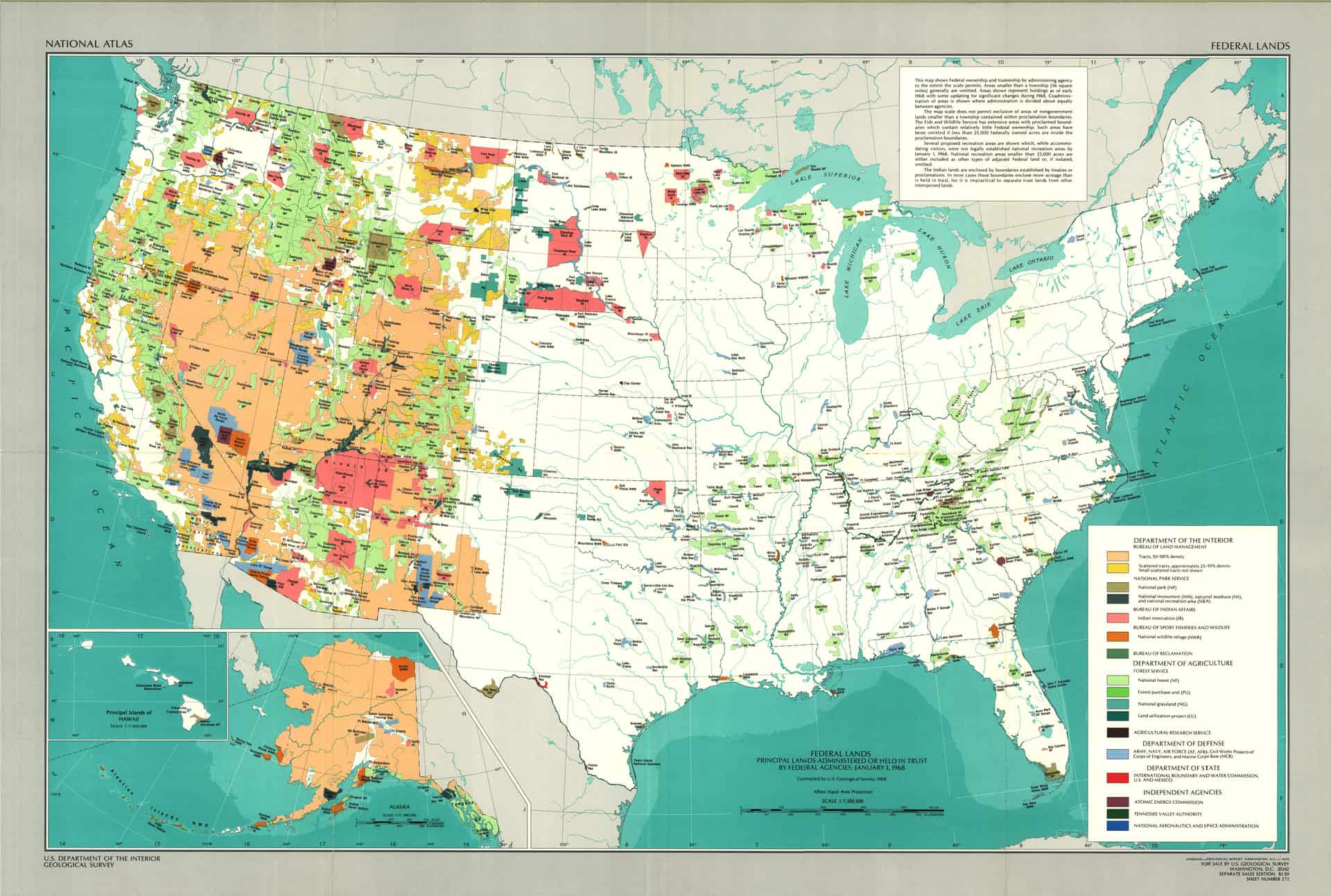
Colorado state forester Mike Lester said there are 24 million acres of forest in the state, 68 percent of which is federal land, and 700,000 acres of wildland-urban interface, where development abuts public lands. The WUI is expected to grow to 2.2 million acres by 2030.

“It’s fair to say we took about 100 years to get in this situation,” Lester said. “And it’s going to take us about 100 more to get out.”

A few miles west of Creede, Starr Pearson, who manages Freemon’s Guest Ranch, struggled with the sparse tourist trade like many area businesses.

But she said residents have come to grips with the natural burn-off and already have started to plan for the inevitable next fire.

“Everybody’s made their peace with it, and now that we know how it goes, we’re ready for another round,” Pearson said. “With all the beetle kill, we haven’t seen the end of it. It’s our new normal.”

Even seasonal residents who once adamantly opposed the concept of controlled burns have started to see the wisdom of that approach, she added.

Public Perceptions of Smoke in Oregon & California Webinar

This is tomorrow.. thought some folks might be interested..

Public Perceptions of Smoke in Oregon & California
Webinar
Thursday, September 5, 2013 – 12:00pm to 1:00pm
NW Fire Science Consortium 2013 Webinar Series

Presenters: Dr. Christine Olsen, Oregon State University and Dr. Eric Toman, Ohio State University.

Drs. Toman and Olsen will describe ongoing research in Oregon and California on public perceptions of wildland and prescribed fire smoke. They will focus on identifying factors that influence perceptions of smoke, and how communication in various forms may influence those perceptions.

Here’s
the link.

Can We Try an Interest-Based Dialogue? A Guest Post by Mike Wood

Map from "One Third of the Nation's Land"
Map from “One Third of the Nation’s Land”

From Mike Wood:

I would like to open up a dialogue concerning the relevance and need for public lands within the United States. My interest in doing so is because I deeply value the experience of wildness and the connections to place and nature that come from working in the woods. These are co-equal to me and represent the closest approximation we can have in the modern to how our species has lived for most of our evolution. I am concerned that most of us in the US have lost touch with these experiences and connections, and with each generation the trend is further away from nature and more toward “virtual” realities. People won’t support that which they do not know. Yet, those of us who know the most spend our time focusing on how different we are from one another, thereby splintering the cohort that could otherwise advocate for even the mere existence of public lands.

Here is the background for opening this dialogue.

A couple weeks ago I called Sharon because I was curious about her goals/intentions for this blog site and whether she felt this forum was serving those goals. As our conversation evolved, we began to philosophize a bit about the role of public lands more generally, and whether or not we could start a conversation here that could take a big step back from the usual debates just to see where it would take us . Following this conversation, Sharon sent me the links to several posts on this blog site concerning the 2010 conference in which the topic was, in part, to revisit the findings of the public land law review commission findings 40 years prior. While I found the posts to be interesting it really left me wondering, as I often do, how we arrived at this point, over 40 years after the PLLRC final report.

How is it that so many conversations here and elsewhere devolve into (my view) distractions from what is the more fundamentally important topics? From what I can see, everyone who participates in this on-line debate over public lands management has a reasonably sharp intellect and most participants have a penchant for writing as well (thus you/we participate in the forum). So what’s at issue here?

As a starting point for conversation and just see if anyone else is interested in this stuff, I wanted to make a distinction between “position” and “interest” based communication. While I’m sure this is a review for most everyone, “positions” are fixed in place and are at best a proximate means for serving an underlying interest. For instance, “I am opposed to commercial timber harvest on public lands” is a “position” statement. The real interesting question, in my view, is to ask “What are the underlying interests that this person is attempting to serve and how is it that they arrived at this position as the best alternative in serving these interests”? How often do most of us question the efficacy of our positions, and/or whether they are even serving our interests at all? On the other hand, how many of us could truly articulate our interests clearly and accurately?

An old piece of wisdom I learned a number of years ago suggests that to know the “truth” about another person’s perspective, you have to ask “why” to each response they provide at least five times with each follow up response going progressively deeper until you arrive at the core of their motivation. While it may not feasible to go this far on this blog site, I am curious as to whether anyone would like to carry on a dialogue concerning our underlying interests on this blog site. I have to admit that I motivated by my desire to keep public lands around at least for the next few generations (I’ve heard something about taking care of the next 7 generations…).

If anyone is interested, we could begin by agreeing that to always stay focused on an interest-based dialogue with ear toward understanding the other without judgment for as long as possible. If no one is interested, that’s OK too of course…

Note from Sharon: here is a post by John Rupe on the Land Law Conference put on by the Natural Resources folks at CU Law. It also has a link to the report One Third of the Nation’s Land (1970). Well worth a read to see how far our thinking about public lands has changed since 1970. What were you doing in 1970?

Presidential Proclamation: September is National Wilderness Month

Wilderness pic

BY THE PRESIDENT OF THE UNITED STATES OF AMERICA

A PROCLAMATION

In September 1964, President Lyndon B. Johnson signed the Wilderness Act into law, recognizing places “where the earth and its community of life are untrammeled by man, where man himself is a visitor who does not remain.” Throughout our history, countless people have passed through America’s most treasured landscapes, leaving their beauty unmarred. This month, we uphold that proud tradition and resolve that future generations will trek forest paths, navigate winding rivers, and scale rocky peaks as visitors to the majesty of our great outdoors.

My Administration is dedicated to preserving our Nation’s wild and scenic places. During my first year as President, I designated more than 2 million acres of wilderness and protected over 1,000 miles of rivers. Earlier this year, I established five new national monuments, and I signed legislation to redesignate California’s Pinnacles National Monument as Pinnacles National Park. To engage more Americans in conservation, I also launched the America’s Great Outdoors Initiative. Through this innovative effort, my Administration is working with communities from coast to coast to preserve our outdoor heritage, including our vast rural lands and remaining wild spaces.

As natural habitats for diverse wildlife; as destinations for family camping trips; and as venues for hiking, hunting, and fishing, America’s wilderness landscapes hold boundless opportunities to discover and explore. They provide immense value to our Nation — in shared experiences and as an integral part of our economy. Our iconic wilderness areas draw tourists from across the country and around the world, bolstering local businesses and supporting American jobs.

During National Wilderness Month, we reflect on the profound influence of the great outdoors on our lives and our national character, and we recommit to preserving them for generations to come.

NOW, THEREFORE, I, BARACK OBAMA, President of the United States of America, by virtue of the authority vested in me by the Constitution and the laws of the United States, do hereby proclaim September 2013 as National Wilderness Month. I invite all Americans to visit and enjoy our wilderness areas, to learn about their vast history, and to aid in the protection of our precious national treasures.

IN WITNESS WHEREOF, I have hereunto set my hand this thirtieth day of August, in the year of our Lord two thousand thirteen, and of the Independence of the United States of America the two hundred and thirty-eighth.

BARACK OBAMA

Readers may also be interested in viewing this short video, American Wilderness, featuring National Park Service Wilderness areas.

Editorial: Listing of O&C lands as endangered rankles

Thanks to the reader who sent this in from the Corvallis Gazette-Times.

The conservation group Oregon Wild last week released a report in which it named western Oregon’s O&C forests the most endangered place in the state.

The ranking is part of an annual report of endangered public lands in Oregon — an annual rundown of areas the group believes are at risk from “logging, mining, pollution and other harmful development.”

We understand that this type of report is crafted to draw public attention. We also understand that writing about the report requires falling into that trap.

But, still, something about this year’s rankings rankles: They are tone-deaf to the broader issues related to the long-running saga of the O&C lands and the counties that rely on them.

These lands, about 2.6 million acres, originally were granted to the Oregon & California Railroad to build a railroad line.

The lands were reconveyed to the federal government in 1916 and now are managed by the Bureau of Land Management. Benton County includes about 53,000 acres of O&C lands.

Since 1916, the 18 counties where the O&C lands are located have received payments from the federal government to compensate for the loss of tax revenue, starting with a 50 percent share of timber revenue on those lands.

As we cut back on timber harvests on federal lands, those payments were trimmed back as well. Now, the counties with O&C lands are struggling, to different degrees, to find replacement sources of revenue and some counties, primarily in southwest Oregon, teeter on the brink of financial failure.

What fuels the worries of Oregon Wild and other groups is a proposal making its way through the U.S. House of Representatives to place the O&C lands into two trusts.

Roughly half of the acreage would be managed for conservation; the remainder would focus on sustainable timber production to help fund county coffers – and maybe even restore some rural jobs in the timber industry.

Oregon Wild worries that the proposal, being pushed by Reps. Greg Walden and Peter DeFazio, among others, amounts to a license to clearcut big swaths of the O&C lands.

We doubt that would be the result — in part because those practices increasingly are unacceptable to the public, but also because no one expects the House plan to make any headway in the Senate. U.S. Sen. Ron Wyden has a similar proposal, which would increase timber harvests on the lands, but to a lesser extent than the House legislation.

It’s likely the two plans will meet in a conference committee.

To its credit, the full Oregon Wild report, while it emphasizes the importance of tourism and recreation, does talk about the need to find a long-term solution to county funding, and it suggests that badly needed restoration work on our forests would get people back to work.

We agree with that. So does everyone else, as far as we can tell. So what’s the holdup?

Sharon’s note: Hmm. I think the “hold-up” is that no one wants to pay for it (!). You could make a downpayment, though, with the 50K or so that went to the Oregonian full page ads…

And at the risk of offending my West Side friends, I have seen many nice forest places to play across the West and I don’t think the rainy, damp West side is among most people’s favorites.
In fact, the people from there tend to recreate on the East side, at least when I lived in the Bend area. I wonder if people considered that in their ideas about tourism replacing timber harvesting? As we used to say in Region 2, “Hope is not a strategy.”

5 Groups Appeal Tongass Timber Sale: 6,000 acres of old-growth would be logged, 46 miles of new roads constructed

The following was sent to me by the Greater Southeast Alaska Conservation Community (GSACC). If you have any questions about the release and the info contained within it, please contact the GSACC directly. Thanks. – mk

On August 16, GSACC and four other organizations filed an administrative appeal of the Tongass Forest Supervisor’s decision to proceed with the Big Thorne timber project. The appeal went to to the next highest level in the agency, Regional Forester Beth Pendleton. The appeal is known as Cascadia Wildlands et al. (2013), and other co-appellants are Greenpeace, Center for Biological Diversity and Tongass Conservation Society.

The project would log 148 million board feet of timber [enough to fill 29,600 log trucks], including over 6,000 acres of old-growth forest from heavily hammered Prince of Wales Island. 46 miles of new logging roads would be built and another 36 miles would be reconstructed. Our points of appeal encompass fundamental problems with the concept of the project, its economic problems, aquatic impacts from roading and logging, and severe impacts to wildlife including wolves, deer, bear, goshawks and flying squirrels. Our Request for Relief is that “the decision to approve the ROD and FEIS be reversed and that the project be cancelled in its entirety because of multiple failures to comply with the Administrative Procedure Act (APA), National Environmental Policy Act (NEPA), National Forest Management Act (NFMA), Clean Water Act (CWA), Alaska National Interest Lands Conservation Act (ANILCA), Tongass Timber Reform Act (TTRA), Federal Advisory Committee Act (FACA) and various regulations and policies implementing these statutes.”

Included with the appeal were three expert declarations. One is by Dr. David Person, who did 22 years wolf and other ecological research on Prince of Wales Island and recently retired from the Alaska Department of Fish & Game. It says that the predator-prey system on the island (which includes wolves, bear, people and deer) is likely at the point of collapse, with the Big Thorne project being the tipping point. Another declaration is by Jon Rhodes, an expert on the sediment impacts of logging roads and their effect on fish. The third is by Joe Mehrkens, GSACC board member and former Alaska Regional Economist for the Forest Service, on the failings of the economic analysis in the Big Thorne EIS and economic nonsense this project embodies.

The appeal and the declarations are available for viewing and download at this link. Because the appeal is 127 pages, you will likely find the clickable table of contents useful. This series of e-mails illustrates the kind of biological knowledge that the State of Alaska has withheld from the NEPA process for the Big Thorne timber sale project on the Tongass National Forest.

ESA and Cypress Tree Listing

The article from Greenwire, below, and this excerpt from the USFWS’s new proposed rule, beg the question: Couldn’t, shouldn’t the agency have obtained better data before listing the Santa Cruz cypress tree as endangered?

“After more accurate
mapping (McGraw 2007, entire), we
now estimate that areal extent totals
approximately 188 ac (76 ha) (Service
2013, p. 43). Additionally, estimated
abundance of individuals in all
populations has changed over time,
from approximately 2,300 individuals at
the time of listing in 1987, to a current
range of 33,000 to 44,000 individuals
(although the latter estimate is variable
due to mortality and regeneration
following the 2008 Martin Fire that
burned 520 ac (210 ha) of land and a
portion of the Bonny Doon population)”

And maybe the cypress stands need some thinning?

Steve


Agency proposes reducing protections for Calif. cypress tree

Laura Petersen, E&E reporter

Published: Tuesday, September 3, 2013

The Fish and Wildlife Service today proposed downlisting the status of the Santa Cruz cypress tree from endangered to threatened.

Found only in a small part of the Santa Cruz Mountains in California, the cypress is no longer at imminent risk of extinction from development, logging or agricultural conversion, the agency said in its proposed rule published today in the Federal Register.

The trees grow on lands managed for conservation by the state and by a private landowner. However, the species faces a number of other threats, so still requires the protection of the Endangered Species Act, the agency said.

“[T]hreats associated with alteration of fire regime and lack of habitat management continue to impede the species’ ability to recover,” the agency wrote in the proposed rule.

The Santa Cruz cypress tree was listed in 1987, when officials estimated 2,300 individuals remained. As information has improved, the agency said that was likely an underestimate. Between 33,000 and 44,000 cypress trees are now estimated to grow across about 188 acres.

The Pacific Legal Foundation petitioned in 2011 to downlist the tree, along with a handful of other species, and sued FWS in April for missing the deadline to issue a proposed rule. The group argues that endangered species listings affect property owners’ rights and can require landowners to undertake costly consultations to receive development permits.

However, the downlisting “does not significantly change the protections afforded this species under the Act,” according to the proposed rule. As before, all federally funded or permitted activities must not jeopardize the cypress’ long-term survival.

Conservationists applauded the proposal.

“The remarkable rebound of this precious little California evergreen is the latest proof that the Endangered Species Act puts species on the path to recovery,” said Angela Crane, endangered species organizer at the Center for Biological Diversity.

Dr. Paul Adams Responds to Oregonian Water Quality Story

On working forestlands, the Oregon Forest Practices Act requires that some trees and snags be left behind during harvest for wildlife habitat purposes. Along with buffer zones along forest streams, road-building activities must be approved under law and water runoff after harvest from the state’s plentiful rainfall is closely monitored. (Photo courtesy Oregon Forest Resources Institute)

UPDATE: HW Policy & Mgmt – AdamsP 07 is a copy of the Adams paper that Loup Loup referred to.

This article was run in the Oregonian on Aug. 20 entitled “Do Oregon’s clear-cut and pesticide buffers protect drinking water from creeks, rivers? “. It makes one wonder if this was timed to raise this question at the same time as Senator Wyden is working on the O&C lands issue- especially when it is not clear that the story fairly depicts the OSU studies, and the Oregonian did not publish Dr. Adams’ response. Fortunately, I was able to obtain a copy of his response and post it here:

Forestry and Drinking Water – Still a Vital Combination

Forestry and clean water, it’s an issue with many angles. On Wednesday, The Oregonian focused on a local controversy while also raising broader questions about forest stream protection and clean, reliable drinking water supplies. But even among these questions and views of the local controversy, some key facts can be gleaned (quotes italicized below from the original Oregonian article) and further illuminated. The latter observations draw from my 30+ years of experience with forestry and watershed research and education.

“Timberlands are easier on water quality than cities and farms.” Not only that, timber harvesting and other forestry activities occur at some level on nearly all of Oregon’s major municipal watersheds. Drinking water quality from these areas remains high because of typically excellent source water and very strict standards for treatment and monitoring, although localized or short-term problems sometimes occur. This is true even in watersheds that have little or no timber harvesting because water quality in forest streams can vary widely with storms and other natural influences.

“Oregon’s rules for private forests are less stringent than in neighboring Washington…” Yes, but this begs the question of whether those stringent standards result in an effective balance of benefits from those forest lands. During 1994-2006, a period when much stricter rules were enacted, western Washington lost about 185,000 acres of forest land to development and other uses. Oregon remains committed to maintaining its private forests in forest land use, and that includes serious consideration of the cost-benefit balance of forestry regulations.

“Stream buffers for aerial herbicide spraying are also smaller in Oregon than in Washington.” Again true, but does water quality sampling in Oregon reveal any current problems? A 2012 analysis by the USGS of the McKenzie River basin, which is Eugene’s water source and includes extensive industrial forests, states: “Forestry pesticide use is not considered a likely threat to drinking water at the present time.” Instead, in this mixed land use basin, “…urban pesticide use is potentially an important source of pesticides of concern for drinking water.”

“The state Forestry Department is working with timber companies, university experts and other agencies on three studies to better gauge the effects of logging on streams.” But contrary to the oversimplified, negative findings exclusively mentioned in the article, these studies are showing very encouraging results about the effectiveness of current forest practices and Oregon’s regulations in protecting water quality, including fish habitat. Some refinement of our rules may follow as the picture becomes clearer but there is no compelling evidence that dramatic changes are needed to protect water quality.

Other long-term water quality data from state agencies already support the general effectiveness of forest practices in Oregon. Oregon’s forest owners also have a history of working collaboratively with water users, and since 1997, they have invested over $95 million in Oregon’s Plan for Salmon and Watersheds. More broadly, these landowners provide an exceptional array and quality of ecosystem services, for which typically they receive no direct compensation. And with persistent pressure to sell or modify forestland for development and other uses, the questions of regulatory costs, benefits and unintended consequences must be taken very seriously.

Paul W. Adams is a Professor and Forest Watershed Extension Specialist at Oregon State University. Any opinions expressed are his own.

Note that Dr. Adams is the same as LoupLoup referred to in his comment here.

Plum Creek Timber Co pays 25 cents/acre for annual firefighting fee assessment

Two weeks after the Lolo Creek Complex fire started, the Montana news media has finally let the public know that the vast majority of forest land burned in the fire is owned and managed by Plum Creek Timber Company, which just so happens to be the largest private landowner in the state.

Blog readers will recall that I was recently critical of the fact that no Montana media outlet apparently saw fit to mention even once or briefly that the Lolo Creek Complex fire was burning mainly on land owned and managed by Plum Creek Timber Company.

According to this morning’s Missoulian: “Most of the forest burned in the Lolo Creek Complex fire belonged to Plum Creek Timber Co., which hopes to recover what it can of the blackened trees this fall.”

Perhaps the most interesting part of the article was this bit of information about just how little Plum Creek Timber Company pays the Montana Department of Natural Resources and Conservation for fighting wildfire on its private land:

Plum Creek also pays an annual firefighting fee assessment of about 25 cents an acre to the Montana Department of Natural Resources and Conservation that works like insurance on all its approximately 900,000 acres of property in the state.

Montana State Forester Bob Harrington said the fee system is similar to programs used in most Rocky Mountain states to support firefighting efforts on private land. The money pays for equipment and training in years when fire activity doesn’t predominate the expenses.

Plum Creek also lost about 1,700 acres of timberland in the West Mullan fire near Superior in July. That area will also be assessed for possible salvage logging.

What do others think about the 25 cents per acre firefighting fee assessment? If it’s a fee assessment that works like insurance, then Plum Creek’s annual fee is approximately $225,000. Not a bad deal for insuring firefighting coverage over 900,000 acres of land, right?

Looked at another way, Plum Creek’s 7000 acres that burned in the 10,902 acre Lolo Complex Fire kicked in a grand total of $1,750 (7000 acres x 25 cents per acre) as per the firefighting fee assessment. I have yet to see concrete cost totals to the Forest Service, State DNRC and taxpayers for the Lolo Creek Complex fire but given the fact that this was the nation’s #1 priority wildfire recently and nearly 1,000 firefighters were fighting it at one point I’d have a hard time believing that total fire suppression costs would be anywhere south of $10 million.

Is this yet another real-world example of the timber industry getting one of the sweetest sweet-heart deals in America? Or does Plum Creek Timber Company (and other timber companies) paying about 25 cents per acre for a firefighting fee assessment pay their fair share of firefighting costs?

Wildfires on the Groveland Ranger District

For over 40 years, I have watched the Yosemite area suffer large wildfires, losing most of its historic old growth. In 1971, I went to the Cherry Lake area, on a junior high field trip, to see forestry in action, on the old Granite Fire. In 1990, I helped lay out salvage cutting units in the A-Rock Fire. There is no doubt that California Indians meticulously managed their domains, including Yosemite Valley. Their ideal landscapes were composed of large, fire-resistant pines, canopies of California Black Oaks and a thick carpet of flammable bear clover. Their skills and knowledge resulted in the majestic pine forests that used to populate the area of the Groveland Ranger District, of the Stanislaus National Forest. This roughly-mapped view shows how large modern fires have decimated the area. Notice that the Granite Fire has been completely re-burned. Whether they are lightning strikes or human-caused wildfires, they are not like the pre-settlement fires ignited by the Indian wise men.

Grovelend-RD1

Historically, this area had awesome old growth forests that survived the extremes in terrain and climate. Below is a view of a part of the Rim Fire that I worked on in 2000. I personally flagged most of these units, enduring thick manzanita and whitethorn. In browsing around, I could see that the project was just finished, when Google collected their images. Landing piles have been burned and the large plantation thinnings were completed. You can see the brushy areas that were left “to recover on their own”, as concessions to wildlife. Fire crews appear to have initiated burnout operations along the road on the right side of the picture. You can also see a patch of private ground. There also appears to be some unthinned plantation on Forest Service land there, as well. There should be some great opportunities to compare treatments. 

Cherry-units

It is clear that we need to learn how to grow “all-aged” forests, which are also as fire resistant as they can be. The Tuolumne River canyon will continue to do as it always has. It will burn, despite what humans do. However, I believe we can act to contain fires to the canyon, for the most part.

www.facebook.com/LarryHarrellFotoware