“Using our nation’s forest inventory to open carbon markets to family forest owners”

Here’s an announcement from the Forest Service about a program designed to promote use of small, private forests for carbon offsets.  In particular, it’s about the the use of Forest Service FIA data in this program, but I’m always interested in what management practices are considered to be worth getting paid for, and I don’t think I’ve seen them this clearly specified.  The program website says, “When you enroll, you’ll receive payments for implementing forest management practices that increase the carbon sequestered and stored on your land.”  This program seems to be only available in the eastern U. S., but if you track through the links you can find the specific “management requirements” for several states under the “Practice Overview” documents here.   The three groups of states are each a little different.

Michigan/Minnesota/Wisconsin (Payments are higher for “growing mature forests” than for “promoting diverse forests;” these are requirements for the former, while the latter allows more intensive logging, but has requirements for reserve areas.)

  • Harvests may not remove more than 25% of the basal area at the time of the harvest.
  • Harvests may not reduce the average stand diameter by more than 10%.

Maryland/Pennsylvania/West Virginia (Payment is for “growing mature forests” only)

  • If you choose to conduct a timber harvest, it must not remove more than 25% of the basal area per acre
  • High-grading is prohibited during the contract period. High-grading is defined as a reduction in quadratic mean tree diameter of more than 10% from the pre-harvest condition.

Vermont/eastern New York (Payments are higher for “grow older forests” than for “enhance your woodland.”  The former generally requires deferment of commercial logging for 20 years.  The latter restricts timber harvest based on basal area, diameter, trees per acre, snags and opening size.)

Would something like this make sense in the west?  For federal lands (as a best management practice, since they couldn’t be paid for it)?  (I know we’ve had some discussions about thinning requirements based on basal area vs other metrics.)


Can We Log Our Forest and Conserve It Too?

Here’s an interesting blog post by Alice Palmer focusing on BC, but applies elsewhere.

Can We Log Our Forest and Conserve It Too?

If we want to transition to a bioeconomy, we will need more biomaterials. Finding them won’t be easy.

Speaking at a recent forestry conference in BC, futurist Nikolas Badminton enthused about recent forestry innovations, such as mass timber high-rises, wood-based windows, and electricity-generating floors. Indeed, one has only to open their daily newspaper to be inspired about the promise of a “bioeconomy” replacing carbon-intensive materials such as cement or plastic with bio-based ones such as wood fibre.

Unfortunately, while wood is increasingly viewed as a climate-friendly building solution, the logging activities that provide this wood are not viewed in the same positive light. Indeed, many people believe industrial forestry to be environmentally damaging in terms of both carbon emissions and biodiversity conservation. These beliefs frequently carry over to the media and various levels of government.

In short, we want to “eat our cake and have it too” – use the wood, but preserve the forest. However, if we want to both take advantage of the multiple carbon benefits of building with wood and conserve 30% of the earth’s surface (as per the UN Convention on Biological Diversity), we’ll need to make some tough decisions.

The author continues with four hypothetical scenarios…. All worthy of discussion.

Scenario 4: Active land management

With climate change threatening biodiversity, conservation groups and the forest industry call a truce. Some forests are set aside for conservation purposes and others are designated for industrial wood production. Previously degraded forests are actively restored and intensive silviculture in the industrial forests reduces the risk of catastrophic wildfires and enables high-quality wood production. These industrial forests rapidly sequester carbon, contributing to global net zero emissions.

The Amazing World of Political Byzantinery… How a CEQ Underling Overruled a Senate-Confirmed Cabinet Secretary

And I’ve been interested, as you know, in how alignment in the USG currently works. Because if the Admin has a stated policy, then are the agencies working together to implement it? What if they disagree? How are arguments worked out in practice? Who is really holding the cards, and why.. and what makes political power exactly.. donations, the buddy system??? And when we think about voting, we need to think not only about the candidate themselves, but who in the Admin will be making decisions and why. Because I’m not a political person (I consider myself politically-impaired and many of my former bosses will agree) but based on my experience, every notable decision from here on in has some 2024 considerations involved. (We used to call this “silly season” and like many things it was shorter during less partisan times).

So today, we have an interesting example, based on the rumor mill (several sources). In this case, the USDA wanted to support the bill on fire retardant that was discussed last week at the Federal Lands Subcommittee Hearing (which was interesting and I’ll have a post or two just on that).

However, as I understand it, the Secretary of Agriculture (a Senate-confirmed Cabinet member) was overruled by an underling at the Council on Environmental Quality. How did this happen? I filed a FOIA to learn more, but anyone who has more information please contact me.

Right now, I can think of two rational reasons for this point of view. 1. Giving more power to the EPA or 2. “They shouldn’t live there anyway”.- kind of a pre-re-wilding point of view. But we’ll see what it says in the FOIA.

Ramping Up Green Energy Permitting.. BLM asks for $20 Mill to Accelerate

I got this map from the Greenwire story so it might not be the latest one.
There must have been something in the air.. after I posted the previous post on BLM geothermal permitting, I found this story from E&E News. It’s paywalled, so here are some excerpts.

It plans to do this primarily through organizational changes designed to more quickly review and approve applications forright-of-way grants for projects on BLM lands, according to a budget justification document.
The budget proposal would allow BLM to:
* Create a “project management office” that would support “technical development of BLM field staff for the review and permitting” of solar, wind and geothermal projects “and related transmission and battery storage infrastructure.” One goal is to coordinate with the Department of Energy to tap into $400 billion in grants provided through the Inflation Reduction Act “to advance clean energy.”
* Name a task force of experts to help with breaking “permitting bottlenecks and challenges,” as well as hiring additional staff at BLM Renewable Energy Coordination Offices in the West who are tasked with prioritizing renewable energy project applications.
* Establish a geothermal regional project support team. BLM has reported that there are 48 geothermal power plants
operating on bureau-managed lands, with a total 2,500 MW capacity.
BLM declined to answer specific questions about its renewables budget request in time for publication.
But the bureau says in the budget document that the increased funding, if approved, would “support siting, leasing, processing rights-of-way applications, and oversight of renewable energy projects and transmission lines connecting to renewable energy projects.”

The FS and other agencies have had trouble hiring people, but maybe these jobs would be work at home so perhaps more attractive.

While the pace of renewables development the Biden administration hopes to achieve might be faster than before, it’s not terribly impressive, either, said Carey King, a research scientist and assistant director of the Energy Institute at the University of Texas, Austin.
King noted that in Texas, which has very little federal land and few zoning laws, the Electric Reliability Council of Texas (ERCOT) already has about 35,000 MW of wind power capacity in operation — by far the most of any state — and has turned its attention to solar. There is more than 8,000 MW of installed solar capacity in 2021, with plans to add another 8,000 MW capacity by the end of this year.
“The BLM plans sound about the same size as Texas rate of permitting/installation,” he said.

But.. the federal lands are subject to a different regulation scenario with a variety of different stakeholders as we have seen in the Geothermal Toad project.

BLM is on pace to approve 48 wind, solar and geothermal energy projects with the capacity to produce an estimated 31,827 MW of electricity — enough to power roughly 9.5 million homes — by the end of the fiscal 2025 budget cycle, according to an Interior Department report to Congress last year (Greenwire, April 20, 2022).
Much of that effort has focused on solar resource-rich Nevada, where the bureau in the last year has removed tens of thousands of acres of federal lands for use while it evaluates commercial-scale projects.
BLM last year removed the equivalent of 185 square miles of federal lands in southern Nevada’s Esmeralda County from new mining claims and other uses for two years while it studies seven utility-scale solar power projects that would have the capacity to produce 5,350 MW of electricity, or enough to power roughly 1.8 million homes (E&E News PM, July 26, 2022).
BLM last week segregated from new mining claims and other uses 5,281 acres straddling Clark and Nye counties in Nevada, about 40 miles west of Las Vegas, while it studies the proposed 500-MW Mosey Solar Project (E&E News PM, March 20).
The Mosey project is near three other large-scale solar project proposals covering nearly 16,000 acres of federal lands southeast of Pahrump, Nev., that BLM in 2021 withdrew from new mining claims while it evaluated each.
But the buildup has prompted some pushback from those worried about impacts to natural resources.
A number of residents in Nevada and California told BLM during an online hearing last month to gather public feedback on the bureau’s plan to update its 2012 Western Solar Plan (E&E News PM, Feb. 14).
“We are basically, to put it very simply, we are right in the middle of this attack of solar on our community,” said Don Sneddon, a Desert Center, Calif., resident who asked BLM to designate in the plan “exclusion zones” around towns and residential areas to prevent solar power plants from encroaching on homes. “Very simply said, the human element needs to be considered.”

As to Biden Admin alignment, it appears that the new Avi Kwa Me National Monument was protected partially in response to concerns of the Fort Mojave Indian Tribe. There’s an open access article on this on Greenwire.

“To us, this is the last of what’s left out there,” said McDowell, who serves as project manager of the Topock remediation project, which aims to address groundwater contamination near the Topock Maze, a geoglyph near Needles, Calif., considered to be spiritually important to the tribe.

“Every time we turn around, there’s a proposal to put in a wind farm or a solar project that would wipe this landscape out,” she said.

McDowell noted that the Mojave are not opposed specifically to wind energy development, but rather its impact on an important area.

“It’s not that we’re against any type of energy development. It’s just where you put it at,” McDowell said. “And unfortunately, to people that don’t live here, don’t come from here … or don’t know the land like the Mojave people do, they see it just as a piece of desert, as a landscape than can be bulldozed and cleared.”

Can We Get There From Here? Wishful Thinking Meets Reality on Federal Lands.. Geothermal Version


This map is from an earlier presentation on this video at 23:15

The Western Governors’ Association has a whole series called “The Heat Beneath Our Feet” about geothermal.  At 28:14 of this video, Lorenzo Trimble of the BLM talks about the BLM process.

Apparently there is a Geothermal PEIS that amended 114 (!) land use plans to incorporate geothermal leases. Improved leasing on BLM and FS, and is not stale. In this presentation, the FS is one Surface Management Agency.

Personally I would prefer that people not say that using a CE (or CX in BLM-ese)  is “not NEPA” as that’s not what the regs say…

Interestingly if you have an oil and gas lease, you can non-competitively apply for a geothermal lease.

New CEQ Guidance on Habitat Connectivity

Cascade Forest Conservancy

On March 21, the Council on Environmental Quality provided “Guidance for Federal Departments and Agencies on Ecological Connectivity and Wildlife Corridors” to federal agencies.  The Forest Service was a member of the working group that developed this guidance.

Connectivity is the degree to which landscapes, waterscapes, and seascapes allow species to move freely and ecological processes to function unimpeded. Corridors are distinct components of a landscape, waterscape, or seascape that provide connectivity. Corridors have policy relevance because they facilitate movement of species between blocks of intact habitat, notably during seasonal migrations or in response to changing conditions… Increasing connectivity is one of the most frequently recommended climate adaptation strategies for biodiversity management.”

“To the maximum extent practicable, Federal agencies are expected to advance the objectives of this guidance by developing policies, through regulations, guidance, or other means, to consider how to conserve, enhance, protect, and restore corridors and connectivity during planning and decision-making, and to encourage collaborative processes across management and ownership boundaries. Any existing corridor and connectivity policies or related policies should be updated as needed to align with the objectives in this guidance. Federal agencies should have new or updated policies ready to implement by the first quarter of 2024 and make their policies publicly available. Federal agencies should also actively identify and prioritize actions that advance the objectives set forth in this guidance.”

“Federal agencies should not limit engagement in restoration activities only to circumstances when restoration serves as a mitigation strategy to compensate for adverse impacts from projects or actions. Instead, Federal agencies should consider where there are opportunities in their programs and policies to carry out restoration with the objective of promoting greater connectivity.”

One of the specific “focal areas” listed in the memo is “forest and rangeland planning and management.”  “Connectivity and corridors should factor into high-level planning and decision-making at Federal agencies as well as into individual decisions that lead to well-sited and planned projects.”  “In carrying out large-scale planning required by statutory mandates (citing NFMA and FLPMA) Federal agencies should consider updating inventories of Federal resources under their associated management plans to assess connectivity and corridors.”

The Forest Service 2012 Planning Rule already includes language requiring that forest plans address connectivity as part of its wildlife viability considerations.  I had something to do with that, but I was regularly disappointed in the agency’s unwillingness to “think outside the green lines” about how species occurring on a national forest depend on connectivity across other land ownerships, so I’m always happy to see someone try to make them do that:

“Ecological processes and wildlife movement are not limited by jurisdictional boundaries. Therefore, Federal agencies should seek active collaboration and coordination with other Federal agencies, Tribes, States, territorial, and local governments, as well as stakeholders to facilitate landscape, waterscape, and seascape-scale connectivity planning and management, and consider appropriate collaboration with other nations. Prioritization and strategic alignment of connectivity efforts across partners improves the effectiveness of each entity’s activities and enables larger-scale conservation, enhancement, protection, or restoration to occur.”

“Federal agencies with investments on Federal lands or in Federal waters adjacent to designated areas that may have conservation outcomes (e.g., National Park System units, national monuments, national forests and grasslands, national marine sanctuaries, national estuarine research reserves, wilderness areas, national wildlife refuges, etc.) should explore collaborative opportunities to enhance connectivity across jurisdictional boundaries.”

These kinds of initiatives seem to come and go, but we should at least expect to see the land management agencies tell us what they think under this administration by next year.  If anyone happens to notice, let us know!

What Happened to This Bill? Public Land Renewable Energy Development Act

UPDATE: I called Levin’s office and it was reintroduced in January and is HR178. Without reading it carefully it looks similar.

Last week we talked about the USG picking some priority sites for renewable energy on Federal lands.  It was proposed by Congressperson Levin (current member of House Natural Resources Committee)  of S. Cal. in 2021. Here’s his press release.

The Public Land Renewable Energy Development Act helps combat the climate crisis and reduce greenhouse gas emissions by promoting the development of wind, solar, and geothermal energy on public lands. The bill includes measures to ensure a fair return for impacted states and communities and directs revenues to fund conservation. In addition, the bill incentivizes development in lower-conflict priority areas, while ensuring impacts to wildlife, habitat, and cultural resources are avoided and minimized.

The bill establishes a revenue sharing mechanism ensuring a fair return for relevant stakeholders. The revenue sharing mechanism will distribute certain revenues derived through the bill by returning 25 percent to the state where development occurs, 25 percent to the counties of origin, 25 percent deposited into a fund for sportsmen and conservation purposes, and 25 percent directed for the purposes of more efficiently processing permit applications and reducing the backlog of renewable energy permits.

Here’s a link to the bill.

(a) PRIORITY AREAS.—
5 (1) IN GENERAL.—The Secretary, in consulta6 tion with the Secretary of Energy, shall establish
7 priority areas on covered land for geothermal, solar,
8 and wind energy projects, consistent with the prin9 ciples of multiple use (as defined in the Federal
10 Land Policy and Management Act of 1976 (43
11 U.S.C. 1701 et seq.)) and the renewable energy per12 mitting goal enacted by the Consolidated Appropria13 tions Act of 2021 (Public Law 116–260). Among
14 applications for a given renewable energy source,
15 proposed projects located in priority areas for that
16 renewable energy source shall—
17 (A) be given the highest priority for
18 incentivizing deployment thereon; and
19 (B) be offered the opportunity to partici20 pate in any regional mitigation plan developed
21 for the relevant priority areas.
22 (2) ESTABLISHING PRIORITY AREAS.—
23 (A) GEOTHERMAL ENERGY.—For geo24 thermal energy, the Secretary shall establish
25 priority areas as soon as practicable, but not  later than 5 years, after the date of the enactment of this Act.
3 (B) SOLAR ENERGY.—For solar energy—
4 (i) solar designated leasing areas (in

5 cluding the solar energy zones established
6 by Bureau of Land Management Solar En

7 ergy Program, established in October
8 2012), and any subsequent land use plan
9 amendments, shall be considered to be pri10 ority areas for solar energy projects; and
11 (ii) the Secretary shall complete a
12 process to consider establishing additional
13 solar priority areas as soon as practicable,
14 but not later than 3 years, after the date
15 of the enactment of this Act.
16 (C) WIND ENERGY.—For wind energy, the
17 Secretary shall complete a process to consider
18 establishing additional wind priority areas as
19 soon as practicable, but not later than 3 years,
20 after the date of the enactment of this Act.

Something that’s interesting about this bill is who endorsed it .. (Ormat are the geothermal folks involved in the geothermal/toad litigation we talked about last week.  Anyway,

The following organizations have endorsed the bill: The Wilderness Society, American Clean Power, Natural Resources Defense Council, Solar Energy Industries Association, EDF Renewables, Ormat Technologies Inc, Trout Unlimited, National Association of Counties, Backcountry Hunters & Anglers, Theodore Roosevelt Conservation Partnership, and Outdoor Alliance.

New study sounds alarm, provides hope for Western red cedars

Interesting article on the latest research. I would note that western redcedar may have done well and expanded its range during and after the Little Ice Age, and the species now grows (and is dying) in areas it in no longer adapted to. A researcher “found young Western red cedars growing alongside drought-hardy Oregon white oaks.” What’s more, the cessation of Indian burning in the Willamette Valley let cedars “invade” areas where previously they would have succumbed to fire. The same in true for Doug-fir — it’s not doing well in sites it wasn’t well adapted to.

New study sounds alarm, provides hope for Western red cedars

Research links cedar death to climate, details which trees are dying, which are surviving and shows how the species might be saved

Robinson Creek Fire

The Robinson Creek Fire, on June 29, 1964, burned 350 acres on Sawmill Ridge.


I was returning to the Bridgeport Ranger Station from an early morning patrol of the Green Creek and Virginia Lakes areas when I detected what became the largest wildfire the Bridgeport Ranger District would experience during my five Toiyabe National Forest fire seasons.

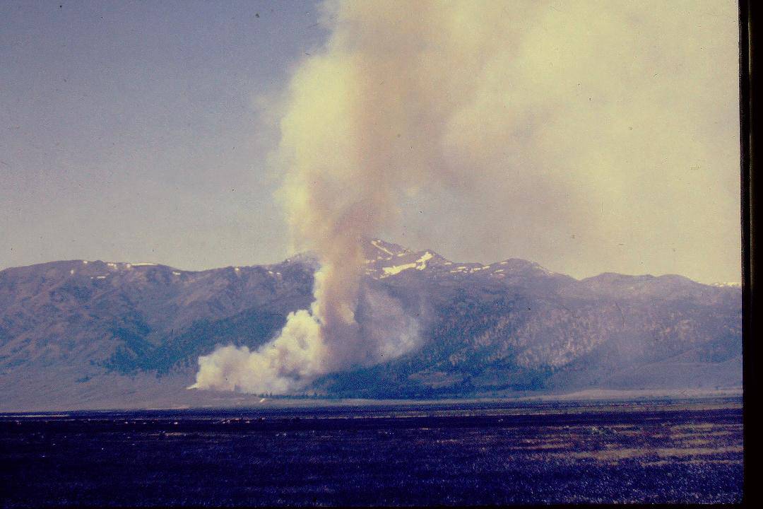
It was June 29, 1964, and having just passed through Bridgeport I was northbound on U.S. Highway 395 when, across Bridgeport Valley to the southwest, I first saw it. Sheep trailing on Timber Harvest Road? Or smoke? Smoke! Wispy white smoke!

Three miles to the ranger station, and maybe eight or ten to the smoke. I tried to raise the station on the radio as I pushed the gas pedal to the floor. The truck responded, but the station didn’t. A glance at my watch told me why. It was lunch time, and with the fire danger rated moderate the office wasn’t staffed. This was years before fire control officer Marion Hysell had a Forest Service radio crackling in his ranger station house day and night.

Two miles to the ranger station. I could have switched to channel two, raised the Toiyabe National Forest dispatcher in Reno, explained the situation, and asked him to telephone the FCO’s house. But I decided I could get there, tell him myself, pick up some help, and be on my way to the still wispy-but-thickening column of smoke before I’d half finish telling the dispatcher my story.

Two minutes later, I came to a dusty halt in front of the FCO’s house and passed the word. Then, with Don, the only crewman not out on project work, I headed up the Buckeye Road toward the fire. After alerting Ranger Hoag, who decided to man the office until the district clerk returned from lunch, the FCO loaded his Jeep with fire tools. As he wheeled toward the fire via Bridgeport and the Twin Lakes road, he confirmed my sighting to Ranger Hoag over the radio. Ranger Hoag alerted the supervisor’s office and the dispatcher, and ordered air tankers.

Fifteen minutes after leaving the station—probably twenty or so after I first saw the smoke—Don and I were speeding down Timber Harvest Road toward a blaze that, at about a mile’s distance, I estimated at ten to fifteen acres and spreading fast through cheatgrass and sagebrush toward the Jeffrey pine-clad slopes of Sawmill Ridge. Through the smoke, on the far side of the fire, a few people could be seen making vain attempts to stop it.

In what was a futile—and probably foolhardy—attempt to head off the fire before it could reach the timber, I left the road and, within a minute or two, Don and I were attacking flames running upslope along a two-hundred-yard to three-hundred-yard front. But two guys with a couple hundred gallons of water and hand tools, it rapidly became obvious, were no match for a fast-moving fire of that size.

About the time I recognized that truth, and also realized that my poor headwork was getting Don and me into more than a little trouble, I saw the FCO’s Jeep jounce over the sagebrush and halt some distance off. “Fall back! Let’s get this rig outta here!” he ordered as he ran our way. So, as I reeled in the hose, Marion maneuvered the patrol truck toward safety. Within a few minutes, the two vehicles and the three of us were back on Timber Harvest Road, and the scene of our “initial attack” was engulfed in flames.

Ranger Hoag’s pickup crossed the bridge over Robinson Creek and he joined us on the road as the fire, now all of an hour old, raced into the timber. Taking charge, he requested a spot weather forecast from Reno and, with the FCO, planned for the reinforcements starting our way.

Since little, if anything, could be done about the head of the fire—then moving rapidly upslope, torching and spotting in the timber—two rag-tag crews of mostly pick-up firefighters were deployed along its flanks to prevent it from spotting and spreading into the nearby resort and campground. From my smoke-choked vantage point with the Timber Harvest Road crew, the fire seemed to be living up to the expectations of the spot weather forecast. Superheated pines exploded. Deer, fleeing the flames, ignored me as they bounded across the road.

Just after two o’clock, an old ex-Navy TBM from Carson City made the first air drop of 600 gallons of bentonite slurry on the head of the fire. If this slowed its advance at all, it didn’t for long. It did boost our morale.

So did arrival of the first substantial reinforcements. Before the fire was two years old, fifty U.S. Marines from the Mountain Warfare Training Center at Pickle Meadows on the Sonora Pass road and sixty State of California inmates of the Inyo-Mono Conservation Crew near Bishop led by California Division of Forestry overhead were on the firelines. By three o’clock, over a hundred Marines were on the fire, and additional pick-up firefighters had been hired. And by four o’clock, when the air tanker’s scout plane had reported the size of the fire to Fire Boss Hoag at about 250 acres, fire control personnel from the West Walker, Alpine, and Carson ranger districts had begun to arrive. A project fire overhead team left Reno about five o’clock, and overhead also began traveling to Bridgeport from the Central Nevada and Las Vegas districts of the forest.

By late afternoon, the situation looked like the project fire it had become. The fire was divided into four sectors, with Marion Hysell as sector boss over Forest Service crew bosses, Marine Corps line workers, and three bulldozers on the “hot” up-hill end of the fire. A PBY and two TBMs made a second series of drops on the head of the fire. Much to my disappointment, I was assigned to set up the fire camp to receive firefighters and equipment as they arrived. By nightfall, the camp and the night shift had been organized. I was eventually relieved as camp boss and told to rest up for a day shift job.

I’ve spent more comfortable nights than that one in a paper sleeping bag out in the sagebrush. While I slept, the major battle of the campaign was fought at the top of Sawmill Ridge.

The plan was to take advantage of the cooling effects of the night air, which would slow the fire down, and stop it with a wide fireline at the top of the ridge. With seven cats and 76 men on this hot sector, Marion was building that line across the ridge from north to south. At eleven o’clock, he tied in with the southern sector’s line to contain the fire. But, two hours later, the wind shifted from the west to blow from the southeast and, as firefighters retreated for air and safety, the fire jumped the line. Another line was started to corral the blowup.

I awoke at first light to a transformed fire camp and landscape. The camp’s population had doubled, at least, and there seemed to be plenty of fresh firefighters for the day shift. A mobile fire weather forecasting unit, complete with spinning anemometer and other instruments, had arrived and was in business. Best of all, a field kitchen was serving breakfast. Dirty, cold, and sore, I ate.

I was assigned to the northern sector as a crew boss, and given a Marine Corps platoon as a crew. The platoon’s sergeant, probably figuring this young Forest Service fellow akin to a second lieutenant, suggested I work the crew-platoon through him. I readily agreed. I held a brief fire school to explain what we were going to do, how to use the tools, and safety before starting up the line. About the only problem I had, as we built fireline toward the ridgetop, was keeping them from bunching up—from working too close to each other for safety.

Fire Boss Hoag declared the fire controlled at noon, just 24 hours after it started. But there was still plenty of mop-up work left.

Late in the afternoon, my Marines and I were relieved by a Forest Service crew from Idaho, and at the end of the day shift I was released to resume fire prevention patrol duties the next morning.

There were plenty of questions to answer during that July first patrol of the Twin Lakes area. Thousands of campers and residents had watched the fire consume 350 acres of brush and timber between Robinson Creek and the top of Sawmill ridge, and everyone wanted to talk about it. I, of course, capitalized on their interest by pushing my fire prevention message. The fire that had so impressed them, we knew, had been man-caused. A couple little boys, the investigation determined, had built a “campfire” in the brush.

Although the fire camp was removed that evening and firefighters from other districts and forests were returned to their stations, mop-up continued for several days.

The smoke of the Robinson Creek Fire had barely cleared when, on July 9, Forest Supervisor Ivan Sack and Frank Dunning, his fire staff officer, conducted the district’s previously-scheduled fire preparedness and readiness inspection. Although we were still mopping up the big one, they told Ranger Hoag and Marion they were pleased with what they saw—including, much to my relief, my fire prevention program. But it seemed to me I was doing everything a fire prevention guard should do well—except preventing big fires.

On the evening of July 21, as I was completing a Twin Lakes patrol, I sighted and extinguished the last smoke. It was a smoldering stump about a third of the way up the ridge. The Robinson Creek Fire was officially out. But, in a way, it would never be out for me. As I crunched my way down the charred slope, it seemed this greatest defeat of my fire prevention career would burn forever in my memory.


Adapted from the 2018 third edition of Toiyabe Patrol,

the writer’s memoir of five U.S. Forest Service summers

 on the Toiyabe National Forest in the 1960s.

Is Something Rare (Almost) Everywhere? Geothermal vs. Toads and the Search for Land for Renewables with Fewest (No?) Impacts

Ormat’s Steamboat Hills geothermal plant outside Reno, Nev., supplies electricity to the Los Angeles Department of Water and Power. (Ormat Technologies)


Update: the Fallon Paiute-Shoshone Tribe is a plaintiff  with CBD on this lawsuit against this project.

Another excellent piece by Sammy Roth of the LA Times in his Boiling Point newsletter. The Times has something like 99 cents for six months which IMHO is worth getting if you only read Sammy’s work. He also has links to interesting articles on wind and solar and wildlife that I hadn’t seen. And perhaps you can sign up for his Boiling Point newsletter without being a subscriber.  This is a controversy about something considered to be good for decarbonization (geothermal) but has localized environmental impacts. We usually see this as a “good ENGO’s vs. bad industry” kind of thing, but this seems to be a “good ENGO vs. good industry” kind of thing. I like how Sammy interviews both Patrick Donnelly of CBD and folks from Ormat, the geothermal company, and tries to put the pieces together.

Looking through our lens posited yesterday considering the Biden Admin and Native people, I don’t see any mention of Native concerns in this piece (I’m checking with the reporter).  Also the Biden Admin would have to go with the science of the USFWS because of the unique science-based characteristics of ESA (Jon can correct me on this).  And perhaps their own views of “scientific integrity” as Jon brought up here yesterday.


The nation’s largest geothermal power company is preparing to sue the Biden administration over its decision to protect a tiny toad, in the latest high-stakes showdown between renewable energy development and wildlife conservation.

In a letter to Interior Secretary Deb Haaland and the director of the U.S. Fish and Wildlife Service — a copy of which was shared exclusively with The Times — Ormat Technologies Inc. warned Wednesday that it would sue the wildlife service in 60 days if the agency doesn’t revisit its decision to declare the Dixie Valley toad an endangered species. That decision might otherwise derail Ormat’s plan for a Nevada geothermal plant that could potentially supply climate-friendly electricity to California.

Federal scientists say the 2-inch amphibian’s wetland habitat — the only place it’s found on Earth — is threatened by Ormat’s renewable energy project. The Reno-based company disputes that conclusion, arguing it’s grounded in shoddy science.

Paul Thomsen, Ormat’s vice president of business development, told me federal officials wrongly assumed his firm’s geothermal production would drain the nearby Dixie Meadows, when the company’s tests have suggested otherwise. He also said the Biden administration had illegally invoked the Endangered Species Act based on speculative future harm to the toad.

“For us, the precedent there is terrifying,” Thomsen said. “If this action were to stand, many renewable energy projects in the West could be thwarted simply based on a concern, with no evidence that they may impact a species in the future.”

“We’re being convicted of a crime that we haven’t committed,” he added.

To help avert the worst consequences of global warming — which is already fueling deadlier and more destructive heat waves, fires, droughts and floods — the U.S. must build huge amounts of renewable energy infrastructure at a breakneck pace.

But across the American West, endangered-species concerns have emerged as a key barrier to construction of solar farms, wind turbines, power lines and lithium mines that would supply electric-car batteries. Lawsuits and protests from conservation activists, Native American tribes and rural residents are poised to slow or block a growing number of projects.

******************


As far as Donnelly is concerned, the geothermal industry has a “dirty little secret,” which is that its facilities frequently dry up hot springs. He pointed me to a 2000 research paper from the U.S. Geological Survey concluding that when geothermal plants are built, impacts to nearby water features such as hot springs, geysers and steam vents “should be viewed as the rule, rather than the exception.” The paper cited several decades-old examples involving Nevada plants since acquired by Ormat.

“There’s this huge body of peer-reviewed literature,” Donnelly said.

When I asked Ormat’s Thomsen about that literature, he told me the geothermal plants cited in the research paper used an older technology that the company has phased out at most of its facilities. As for Dixie Meadows, he told me Ormat’s flow testing found no direct connection between the deep geothermal reservoir and shallower springs that he said feed the wetlands.

He also noted that Ormat recently reduced the plant’s proposed size from 60 megawatts to 12 megawatts, and that the company agreed to extensive real-time monitoring to ensure the wetlands aren’t affected. He said the monitoring would cost roughly $1.5 million a year during the geothermal facility’s operation, adding to a likely construction cost of around $60 million.

Federal officials, Thomsen said, failed to take those factors into account before protecting the Dixie Valley toad last year.

“We support the Endangered Species Act,” Thomsen said. “We want it to be implemented properly.”

***********************

An Interior Department spokesperson declined to comment on Ormat’s 60-day notice warning of a potential lawsuit.

But in its species assessment of the Dixie Valley toad, Interior’s Fish and Wildlife Service cited research that it said showed the springs feeding Dixie Meadows “are not hydraulically isolated from the underlying geothermal reservoir.” As a result, the toad’s wetland habitat “can be impacted by production pumping and/or injection for the geothermal project,” the agency wrote.

Donnelly, meanwhile, pointed me to data showing that temperatures and water levels increased in one spot at Dixie Meadows after Ormat finished flow testing — a possible indication of underground hydraulic links that could put the toad at risk.

“The toads have this incredibly delicate relationship to temperature,” Donnelly said. “If you start cooling off those springs, they might all freeze to death. And if you start heating up those springs, they might all boil to death.”

Asked about the temperature and water level changes, Ormat’s senior legal counsel, Laura Jacobsen, told me via email that small amounts of data from a single spring are “far from sufficient to establish the flow test impacted the springs,” especially with temperature readings “within the variable baseline range for that spring.” The company also pointed me to a Bureau of Land Management document concluding that flow tests “indicate little to no observed changes in spring discharge conditions.”

************

I’ve been shining a light on similar battles across the region through The Times’ Repowering the West series. I’m now writing Part 3, dealing with solar sprawl in southern Nevada. Next month I’ll travel to Idaho to report Part 4, about why the red state’s dominant power company set a goal of 100% clean energy even when lawmakers haven’t ordered it to do so.

In the meantime, Dixie Meadows is far from the only geothermal conflict I’m tracking. Another project contemplated by Ormat could be built just outside Gerlach, a Nevada town best known as the gateway to the Burning Man art and music festival. Local residents and Burning Man leaders are fighting to block exploratory drilling, saying a geothermal plant could industrialize their rural outpost and scare off tourists. The San Francisco Standard’s Maryann Jones Thompson wrote about the controversy.

I was also struck by a recent study from the U.S. Geological Survey, funded in part by Ormat, finding that populations of greater sage-grouse — an iconic Western bird known for its mating dance, and a prime example of the extinction crisis — “declined substantially in years following the development of the geothermal energy plants” in Nevada, as the Geological Survey described the study. The agency has built a mapping tool that it says can help companies find low-impact spots to build geothermal plants.

“It’s great that they’ve developed a tool that can identify areas that are more or less sensitive,” Ormat’s Thomsen said.

Ultimately, that’s what it’s going to come down to: finding the best places to put renewable energy. It’s as true for small-footprint geothermal plants as it is for sprawling solar farms, vast fields of wind turbines and lengthy power lines.

A person could wonder if the first step in renewable energy buildout would have been to work with companies to identify sites with less potential for wildlife and Indigenous concerns. Rather than set targets, make assumptions, fund companies, and when they are far down the road, say “oops, not there.”

Seems like we might have done better by making sure top-down determinations of what should be done with renewable energy installations are actually viable in the real world.