There are many AGW-Climate Change philosophical differences that are out there that may influence forest planning. I’m sure there are more that readers can add. I’ll use “you” to mean a forest or other planning entity.
1. How do you handle uncertainties about future climates? How explicit are you about them? How do you treat model outputs, or like Denver Water, do you use a pretty broad uncertainty envelope? How do you combine uncertainties about climate with uncertainties about other things.. population, recreation use, economics? Do you use scenarios and involve the public, or what is your approach to discussing uncertainties with the public? (this was discussed more generally in the previous post).
2. I give adaptive management its own category here because it is something that the FS (and BLM?) were supposed to be doing, but may have had trouble. At least at the level that some have talked about it (extremely formalized, scientist design, and so on). Perhaps at the District human being observational level or the specialist level (say fuels or wildlife or reforestation) it is working just fine using old-fangled communication- person to person and through professional groups. But maybe different “adaptive management” aficionados simply mean different things by their use of the term. How is adaptive management currently working on the forest, and how is the plan going to help- does it have a role; what are the requirements of the 2012 Rule on this, and how are they being applied?
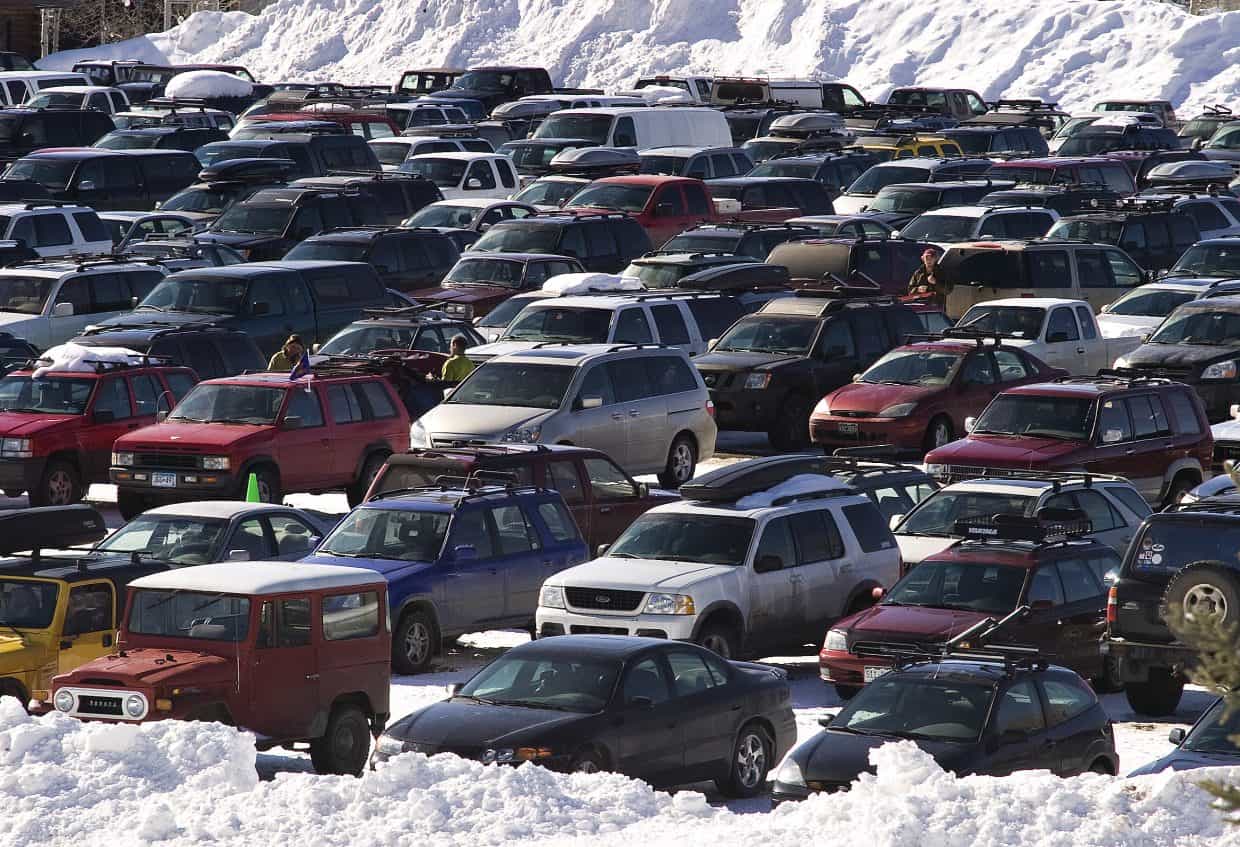
3. Climate mitigation. Seems like we mostly hear about SOSO (same old same old) with regard to mitigation. ENGOs who didn’t want to cut trees now say it’s bad for carbon. ENGO’s who don’t like cattle grazing say it’s bad for methane. Less fossil fuel leasing seems like it would be mitigation, until you analyze it and discover that the sources simply move to private land or offshore. And what about recreation? Most recreators, myself included, use vehicles to access NF lands that are powered by fossil fuels directly or via electrical sources. What are the key issues in the plan vis a vis mitigation?
4. There’s also a bit of meta-thinking that I call Climate Everythingism.
To some, climate now the mantle for everything- other environmental issues, all natural hazards, as we have seen with EPA, CEQ, and many media outlets now have environment as a subset of climate. Check out the WaPo main page where Environment is a subset of Climate.
Others think that climate another source of uncertainty, like population and economics, which all need to be addressed through planning- and it is the role of each discipline to learn about what CC means for their resource.
Most Everythingists I’ve met consider themselves to be “climate experts” (whether I would consider them that or not). But for every Forest Service Everythingist who thinks we need climate specialists advising on each project, there is someone outside the Forest Service who thinks the agency itself can be done away with and replaced by a Climate Adaptation Agency staffed with.. climate experts.
I often find what is least talked about in these discussions are the disciplinary and authority implications of Everythingism, as well as moving the locus of knowledge and authority away from experts on the ground and the people most affected. At its worst Everythingism could be a systemic antagonist to the idea of empowering disadvantaged communities. I find Everythingists not usually involved with forest planning, but their ideas are in the atmosphere, and may well be among partners and the public, so I think it’s something to be aware of.
Addition: I just ran a across a job ad for a Climate Editor at Vox Media on Linked-In. Under “About the Job” it says:
Climate change is the most important story in the world. It’s no longer a looming consequence in the far-off future, but rather a present challenge that’s forcing all of us to adapt. Wildlife and natural habitats are disappearing, driving a biodiversity crisis.
If you’re an Everythingist, I suppose biodiversity is a subset of climate. It’s a mantle that you can place over everything, except perhaps non-native invasive species. But we don’t hear about the latter much anymore.
Please add your own philosophical differences that may affect the approach to climate change in forest plans.
This is the first of a series of posts that lay out a framework for thinking about how forest plans address climate change. Some people are curious as to what we might think are the forest plans that have handled climate change the best, and so we’ll have a post later that will ask that question.
But I think we need to be upfront on where we stand on different approaches or philosophies for how AGW-CC (I’ll just call it CC for the rest of these posts) should be handled. It seems to me that there are two components to this question: first, do you agree with the approach of how they handled it, and second, given their approach, how well do you think they handled it?
I hope by consciously thinking about how diverse approaches might work, we might be able to contemplate the true diversity of approaches in addition to what is in current forest plans.
One of the things I did around 2010-ish was help forests in Region 2 develop their “climate action plans”, I think they were called. I was the climate change coordinator for the Region, so I was on some of the conference calls. The interesting thing about this effort was that it was not tied to NFMA planning, but more about “are there things we are doing we would do differently if we considered climate change?”. In many cases, they already were considering CC and the plan simply documented how they were thinking about it.
Our Regional view was to use generic scenarios based on down-scaled models (I mean really generalized, like “hotter and drier” generalized) and to use a “no regrets” strategy.
Just now I tried to find a definition for “no regrets’ strategies and discovered a plethora of literature with not-exactly-identical definitions.
But I liked this one from Law Insider (!)
no regrets means taking climate-related decisions or actions and/or investments that can be justified from economic, social, and environmental perspectives whether or not a specific climate threat materializes in the future, and this is achieved by building resilience to different hazards/risks (Heltberg, Siegel, Jorgensen, 2009; Siegel, 2011).
Well, Region 2, if I can generalize, has always been a relatively poor Region and employees are pretty pragmatic and don’t tend to overthink things.
So we ran through some of this stuff with one forest (may have been the Nebraska) and the conversation went something like this:
“So we need to protect our riparian areas because it might get hotter and drier?” a Forest employee asked.
“Right,” we said.
“And we need to monitor what we do to be sure it works as the climate is changing?”
“Yes,” we agreed.
“In other words, for climate we should be doing the things we were already supposed to be doing?”
“Well, there are some differences, but.. pretty much.”
*********************
That was perhaps too minimalist for some. Today I’d add consciously managing for resilience.
But why not manage for resilience under a variety of future climate (and other) scenarios? When we visited Denver Water and looked at their scenario planning, climate wasn’t the only unknown. At the time, they also considered different plausible scenarios about populations and their uses of water. If you look at their website, they are not even sure about hotter and drier, but also include hotter and wetter.
Denver Water is adapting to, and addressing, climate change through what it calls “scenario planning.” That means building flexibility into its operations and decisions to prepare for a range of plausible futures climate change could bring. Simply put, those scenarios range from warmer and wetter to hotter and drier.
“Uncertainty is the name of the game going forward,” said Laurna Kaatz, Denver Water’s climate program manager. “We don’t know exactly how it will unfold on the ground, but we do know it’s going to keep warming. Climate change is here and now.”
Then there’s resilience of communities to climate hazards (or things now defined to be “climate” hazards such as drought, wildfire, and flooding). For example, in this Western Watersheds Assessment study plan,
but could take the form of collaborative scenario planning processes that engage diverse stakeholders to explore climate projections, sources of vulnerability, and strategies for increasing resilience.
Which sounds like what the FS may have done a while back (at least some forests did this with the aid of FS R&D) . And of course, community resilience is related to economics, so that ties back to a topic that fits forest planning.
Next time: Some Categories for Climate Approaches in Forest Plans
Anonymous posted this link under “Topics of Interest”. It says it’s a proposed rule..
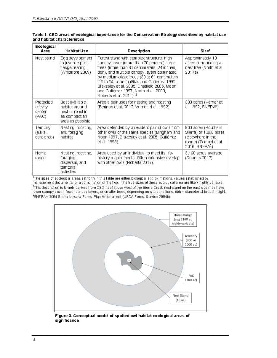
We, the U.S. Fish and Wildlife Service (Service), propose to list two distinct population segments (DPSs) of the California spotted owl (Strix occidentalis occidentalis), a bird species from California and Nevada, under the Endangered Species Act of 1973, as amended (Act). This determination also serves as our 12- month finding on a petition to list the California spotted owl. After a review of the best available scientific and commercial information, we find that listing the Coastal-Southern California DPS as endangered is warranted, and that listing the Sierra Nevada DPS as threatened is warranted. Accordingly, we propose to list the Coastal-Southern California DPS as an endangered species under the Act and the Sierra Nevada DPS as a threatened species with a rule issued under section 4(d) of the Act (‘‘4(d) rule’’). If we finalize this rule as proposed, it will add these two DPSs to the List of Endangered and Threatened Wildlife and extend the Act’s protections to them.
She/he/they added .. “including a bunk 4(d) rule.”
Claudia Elliott asked how this determination of “threatened” might change the management of giant sequoias and asked for our help and insights. Also, she asked what is a 4(d) rule?
It would be great if someone could explain the steps in the process from here on in, and especially how that ultimately gets translated into management direction, including where the public might be involved. Thanks!
**************************
We can also discuss 2ndLaws comment under Steve’s post. Hopefully it won’t be confusing to focus all the current CASPO discussion on this thread. Here’s 2nds comment:
This listing announcement is foreshadowing a aggressive program of “logging it to save it” even though it is well-established (thanks to the state-and-transition models used by carbon scientists) that the adverse effects of fuel reduction logging, plus unavoidable wildfire, are worse for spotted owls than the effects of wildfire alone, due in large part to the low probability that fuel logging will interact with wildfire during the brief period that treatments are effective.
Raphael et al (2013) used a state-and-transition model to explore the effects of landscape fuel reduction logging on spotted owls and found:
Active fuel reduction activities in moderate habitat contributed to substantial short-term (simulation years 0 to 30) population declines under the larger area, higher intensity scenarios. … The combination of BDOW interactions and high-intensity, larger-area treatments contributed to the most substantial NSO population bottlenecks. … It appears that management regimes that take out owl habitat through treatments (either current or potential future) do not reduce the amount of habitat that is lost to wildfire enough to make up for the habitats lost through treatments.
Principle Investigator: Dr. Martin G. Raphael. Project Title: Assessing the Compatibility of Fuel Treatments, Wildfire Risk, and Conservation of Northern Spotted Owl Habitats and Populations in the Eastern Cascades: A Multi-scale Analysis. JFSP 09-1-08-31 Final Report, Page 19. http://www.firescience.gov/projects/09-1-08-31/project/09-1-08-31_final_report.pdf.
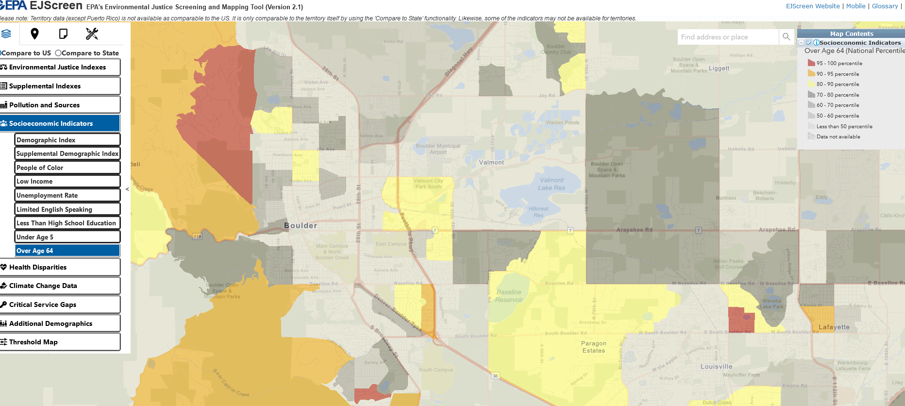
All of the maps in this post can be clicked on to see more clearly.
This is the second in two posts about the Justice 40 Initiative and the EPA and CEQ maps. The CEQ map is called the “Climate and Economic Justice Screening Tool” while the EPA map is called the Environmental Justice Screening and Mapping Tool. That’s why I first became curious about these efforts… something like “how many agencies does it take to map screwing in a light bulb?”
For those of you concerned about government duplication and inefficiency, it appears that both maps use the same Front Street data. I’ll talk some more about that data source in another post.
I’d like to call your attention to a couple of things, though.
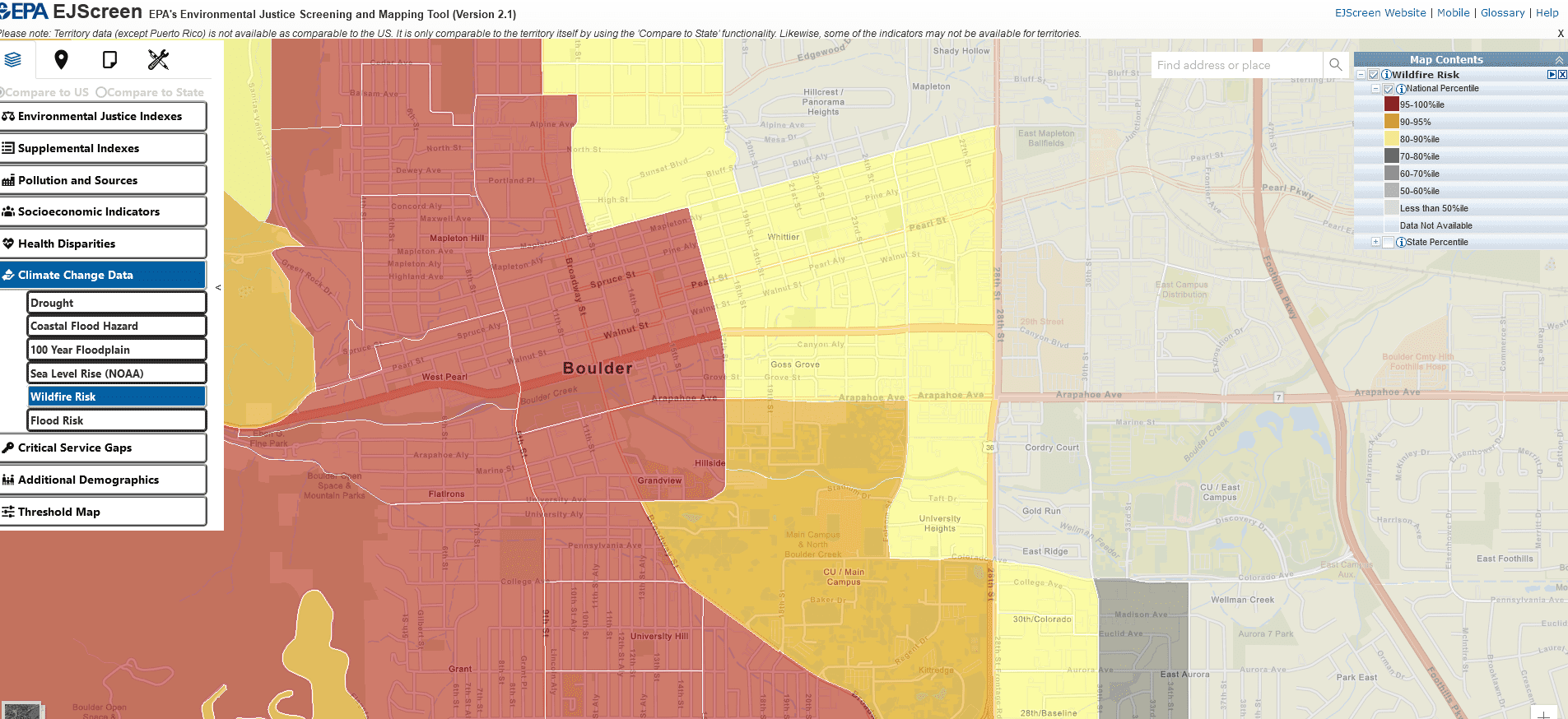
(1) According to the EPA map, all these topics are “climate change”. Drought, coastal flood hazard, 100 year floodplain, sea level rise (NOAA), wildfire risk, and flood risk. So it appears that risks may already have climate change already modeled into them. Fortunately for wildfire we can look at the Front Street results and find they used a reasonable 4.5 scenario. But it’s not particularly clear that all these estimates used the same one, or that they modeled climate the same way. Perhaps it doesn’t matter as EPA says
Screening tools should be used for a “screening-level” look. Screening is a useful first step in understanding or highlighting locations that may be candidates for further review. However, it is essential to remember that screening-level results:
do not, by themselves, determine the existence or absence of environmental justice concerns in a given location
they do not provide a risk assessment and
have other significant limitations.
So they are saying, we mapped risks but .. they may not be accurate? It seems to me that non-ground-truthed maps can lead to a kind of bad mapping snowball, where more and more policies are based on maps which were never intended for that purpose and are.. well.. wrong for what the policy is intended to do. We have seen that before with scientific papers in which authors use others’ data inappropriately (according to the people who collected it). Mapping also can obscure the differences between measurements and models. Like is PM 2.5 measured or modeled? You have to look at the fine print to figure that out.
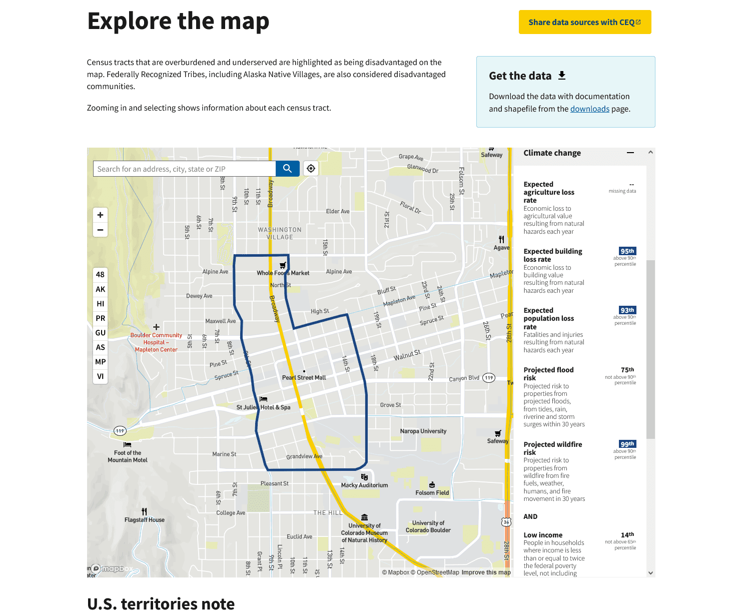
(2) But let’s go back and look at downtown Boulder. The EPA map simply says that it has a 95-100% wildfire risk in case you can’t read the numbers in the graph above. Below is the CEQ version, which explains the numbers a little better.
So the good news is that both agencies seem to be using the same data, and based on my sample size of one, come up with the same numbers for the same area. But let’s see what CEQ tells us that the 99 (!!!) percent number means.
Projected wildfire risk
Projected risk to properties from wildfire from fire fuels, weather, humans, and fire movement in 30 years.
Note: the next census tract east is in the 78th percentile for wildfire risk.
*****************
So let’s go back to what EPA says “they do not provide a risk assessment”, so what does that actually mean? I don’t believe that there is any probability that fire suppression folks in Boulder County will let a fire run through downtown Boulder in the next 30 years. So is this risk as if suppression didn’t exist (because it’s hard to model, I grant you that?). Or is it 99% of something else?
What is the argument for mapping and amplifying (what appear to be) bogus numbers? Why put risk numbers on the map if they are not appropriate for assessing risks? I think part of this could be a language problem.
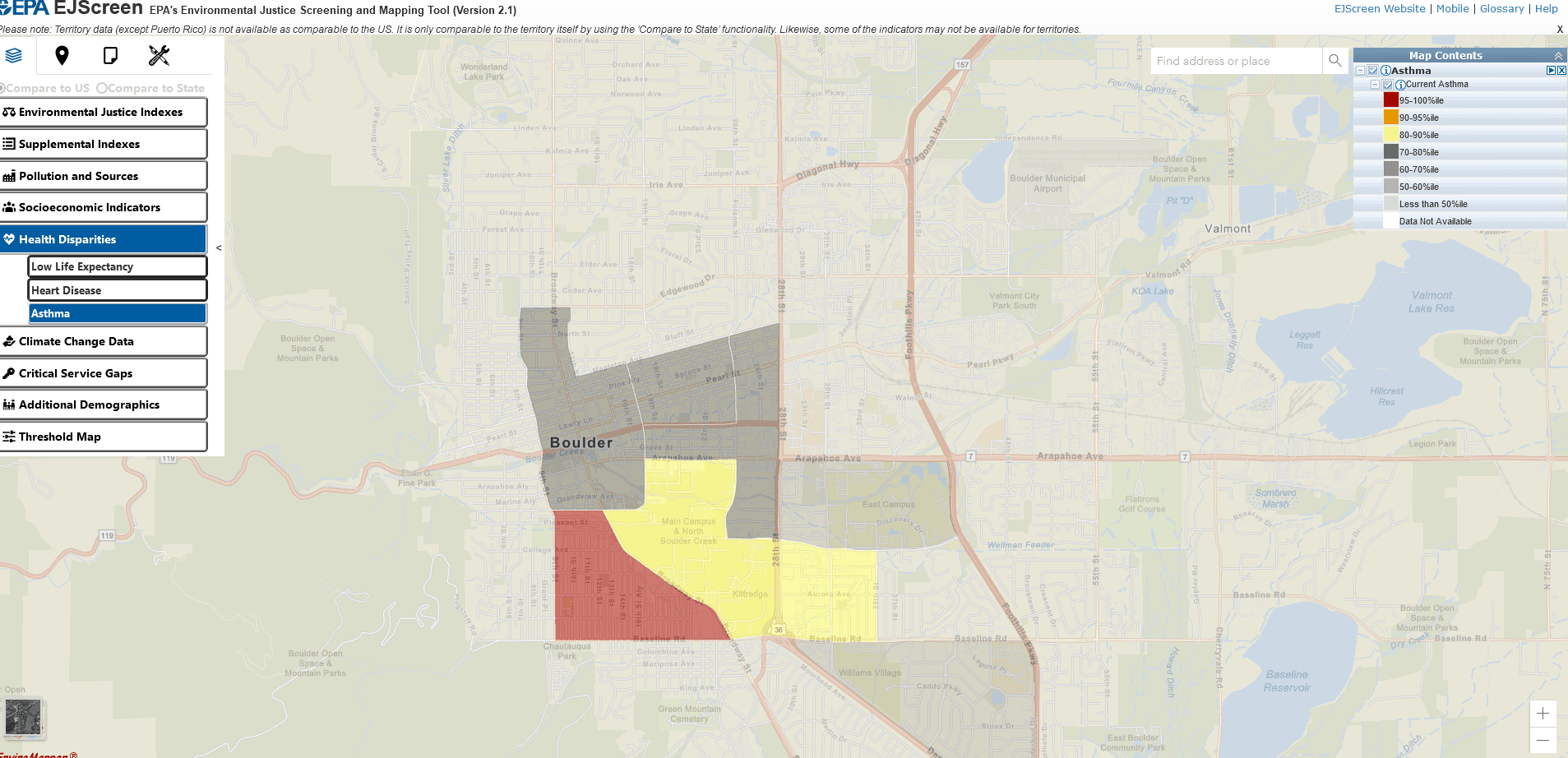
Below are some non-wildfire maps I thought were interesting. Asthma, below.
Population over age 64- red is 95-100%. So maybe that actually means 95-100% of the highest number in the US somewhere.. but if so why not use the numbers themselves? Very puzzling.
It’ll be interesting to see what come of this effort….
Reminder: Innovative Finance for National Forests RFP Deadline March 6
The IFNF grant program supports the development and implementation of innovative finance models that leverage private and public capital other than U.S. Forest System annual appropriations to enhance the resilience of the National Forest System. The grants are funded and administered by the USDA Forest Service National Partnership Office and the U.S. Endowment for Forestry and Communities. Up to $2 million is available this grant cycle. The RFP and additional materials are available at www.usendowment.org/ifnf.
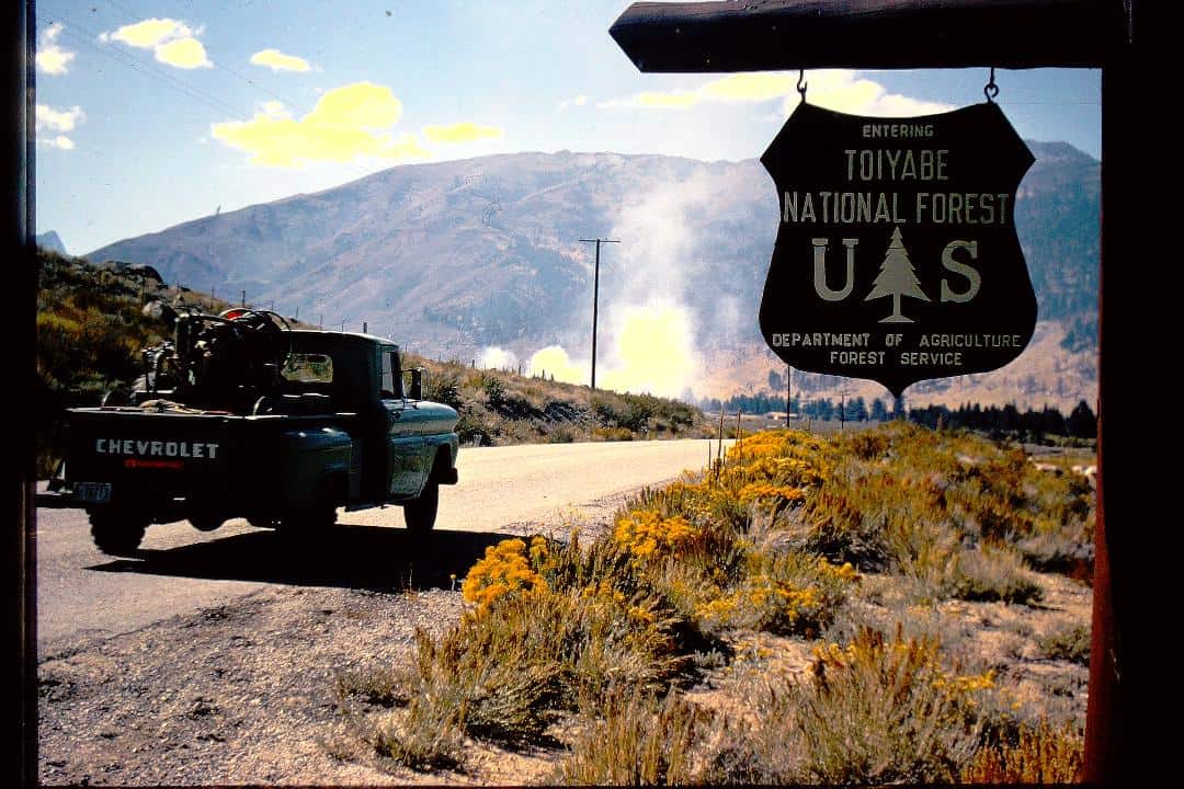
When a fire prevention guard spots or gets a report of a smoke, he’s temporarily out of the fire prevention business and in the fire suppression business. (Yep, I staged this photograph using smoke from a Forest Service dump!)
On July 22, 1963, with not a fire on the Bridgeport Ranger District yet that summer, my fire prevention job of the day was hazard reduction. Don, a new fire crewman, and I were clearing cheatgrass at strategic locations along the Buckeye Road to remove flash fuels that could carry fire into the canyons.
At about half past noon, and halfway through our lunch break, a carload of fishermen, speeding along the road toward the ranger station, honked to a stop to report “a big fire running up the mountain near Eagle Creek!”
Don and I were in the fire rig and on the way in seconds. As I radioed the four-eleven—emergency fire call—to the ranger station, it occurred to me that this fire was man-caused. There hadn’t been a lightning storm in weeks.
We arrived at the fire about the same time the fishermen reached the ranger station with their exaggerated report. I sized up the small blaze burning in brush under a few Jeffrey pines near the old Buckeye Pack Station and cranked up the pumper.
Then, as Don attacked the flames with water, I hit the radio. Fire Control Officer Marion Hysell, on the strength of the fishermen’s report, had just ordered an air tanker. I advised my boss we would soon have the fire under control and to cancel the air show. The fire was knocked down in minutes. Marion drove out to check up on us, and helped us mop up.
We thought there was something fishy about the fishermen’s report of this “big fire near Eagle Creek” that wasn’t, but had nothing other than that mere hunch on which to go.
The flash fuels cured as expected, and the district’s fire danger remained high most of the rest of the season. But, even after many August lightning storms, that small man-caused fire somehow remained the only fire of my first fire prevention guard fire season.
The district wouldn’t always be so lucky.
Adapted from the 2018 third edition of Toiyabe Patrol, the writer’s memoir of five U.S. Forest Service summers on the Toiyabe National Forest in the 1960s.
Les Joslin’s story last Saturday about Smokey Bear signage reminded me of Nagy et al. ‘s paper, which I wrote about on TSW here on Monday. There must be something in the atmosphere, because today Nick Smith had a link to an article on this Higuera et al. paper in his newsletter today.
Here’s the story in the Bozeman Chronicle. A few interesting points..
A new study shows that structure loss from wildfires rose nearly 250% across the Western United States over the last decade and 76% of wildfires that burned homes and other structures were human caused.
******
Just under 80% of the structures that burned in wildfires between 2010 and 2020 were located in California. While that state dominated the trend, the number of structures lost to wildfires increased overall in every Western state, apart from New Mexico.
**********
When it comes to policy solutions, Higuera sees several. First, people can re-emphasize the “Smokey the Bear” message, particularly later in the fire season. Second, they can consider large-scale changes in how, where and whether they build. (my bold)
*****
While solutions may differ from region to region, they could involve rethinking “how power gets transmitted across the landscape” and the affordable housing crisis, which is part of what’s leading to development in flammable vegetation, according to Higuera.
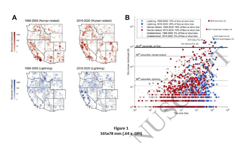
Here are the conclusions from the paper (open access, hurray!). I tried to remove all the page numbers but may not have been entirely successful.
Our study reveals key drivers of the wildfire crisis in the West, and therefore when, where, and which “levers” can be pulled to reduce the chances of future fire disasters. We focused on structure loss as an acute negative impact of wildfires, highlighting a significant increase in structures destroyed by wildfires, by over 3x between 1999-2009 and 2010-2020 (Fig. 2B). Critically, we also show that wildfires have become more destructive, with the number of 19 structures destroyed per 1000 ha burned increasing, by 160% between the last two decades (Fig. 20 2C). This West-wide pattern was dominated by California and from events in just three recent years (2017, 2018, 2020), but nearly every Western state exhibited higher structure loss rates over the second decade of the 21st century (Fig. 4I, S4).
Increased loss rates indicate that wildfire-related structure loss did not increase simply due to more area burning. Likewise, although our analysis did not resolve structure exposure to individual wildfires, we estimate that the proportion of structures destroyed by wildfire outpaced higher structure abundance in flammable vegetation alone (Table S1). The causes of increased structure loss thus reflect complex human-environment interactions, not “either” more area burning “or” increased development, but both, and more. When and where human-related ignitions occur, how many structures are built among flammable vegetation, and how climate 30 and land use affect fuel abundance and fuel aridity over timescales of days to decades are all interacting to drive trends in structure loss.
Recognizing the complex drivers of fire disasters has important implications for mitigation and adaptation. For example, efforts to reduce structure loss must look beyond simply limiting area burned generically. In fact, across the West 88% of wildfires, accounting for 45% of the total area burned, had no associated structure loss (Fig. 1A). While not explicitly assessed here, much of this burning is not a crisis per se and can provide resource benefits (41–44). The wildfire crisis generally and structure loss specifically are largely driven by extreme events, highlighted clearly in recent years (Fig. 1B). The overwhelming majority of wildfires that result in structure loss are started by human-related ignitions, and they are occurring in regions with increasingly high structure density within flammable vegetation (21; Fig. 4J). Consequently, the number of structures destroyed by wildfire in the West in any single year was well explained by the total area burned from human-related ignitions; and, total structure loss in a state over the past two decades was well explained by the number of structures in flammable vegetation (Fig. 5). Both elements have increased between the past two decades – area burned from human-related ignitions by 51%, and structure density by 39% (Fig. 4) – and are leading contributors to increased structure loss rates.
While numerous studies highlight increased fuel aridity from anthropogenic climate change as a key enabler of rising wildfire activity in the West (6, 14–17), in parallel to these changes we have shown that human factors operating over shorter time scales are increasingly contributing to wildfire disasters. The consequences of human-related ignitions, specifically when and where fuel aridity is high and lightning ignitions are rare, are becoming magnified in the context of climate change. Therefore, efforts to reduce human-related ignitions will be increasingly important beyond historical lightning-caused fire seasons, for example in spring, fall, and even winter months (Fig. 3F, S5).
(my bold, and I would add based on experience in my part of the country “the ability of fire departments to jump on them quickly when they do occur.”)
The patterns highlighted here varied widely across the West, emphasizing the importance of understanding spatial and temporal characteristics of wildfires – fire regimes – as integrated social-ecological phenomena (29, 30, 45). Mitigating anthropogenic climate change, given its impacts on fuel aridity (14, 6, 19), is a clear overarching necessity for addressing the wildfire crisis. At smaller scales of individual states, policymakers and managers may benefit from emphasizing other aspects driving increased structure loss, including structure expansion into flammable vegetation, increased ignition from human-related sources, or in states with below- average structure loss, reducing the chances of lighting-ignited fires spreading into developed areas (32, 43). Mitigation and adaptation approaches in predominantly rural states, like Wyoming, Montana, and Idaho, may look different than in more densely populated states, like California, Colorado, and Washington. Additionally, states with low structure loss rates may look to those with high structures loss as harbingers of future change, and ideally glean ways to avoid similar outcomes as structure expansion and densification trends continue. Two clear implications emerge from this and other recent work (20, 21, 32, 33) to help prevent wildfires from becoming disasters: reduce unintentional human-related ignitions, particularly near homes and during periods of extreme fire danger; and carefully consider if and how structures are built, including building with fire-resistant materials, minimizing flammable vegetation near structures, and providing mechanisms to do so equitably across socioeconomic conditions.
****************
I think most of us would agree , as the authors say, that the entire wildfire problem or issue is partially social (as is pretty much everything) in nature. So my questions are:
1. Where is the social science around these human factors and what interventions work to change them?
Unplanned ignitions from human sources – ereafter “human-related ignitions” – include backyard burning, downed power lines, escaped campfires, etc., and are a well-recognized component of contemporary fire activity across the
United States (22, 23)
After all, there is a great deal of good literature on attitudes toward prescribed burning and fuel treatments. But maybe I’m not aware of the literature on strategies to reduce human-caused ignitions.
2. If there is none, why not?
Is it because it’s unstudiable for various reasons (under the litigation cone of silence?), or because there aren’t enough social scientists around, or because it’s not popular with granting agencies, or ???
From E&E News (subscription). The links in the article are to the documents on the NAFSR web site.
Climate change poses ‘new reality’ for Forest Service, former officials say
A Forest Service retirees group issued recommendations for climate-smart forest policies.
The organization representing retired Forest Service officials urged their former employer to more aggressively address the changing climate, warning of mounting threats to the nation’s forests.
“Changing climatic conditions and weather patterns are affecting all the nation’s forests,” the National Association of Forest Service Retirees said in a letter accompanying two position papers on the issue.
“We believe that the cascading effects of extreme events require greater focus and attention because of their many effects on communities and people,” said the letter to Homer Wilkes, undersecretary of Agriculture for natural resources and environment.
The association said it supports the Biden administration’s near-term approach, including a wildfire strategy mapped out by the Forest Service to accelerate and expand forest management practices aimed at reducing wildfire risks.
In the position papers, the organization noted advances in the science around climate-smart planning and management since 2000, and suggested a need for more public investment in that area — an issue that could arise in negotiations around the 2023 farm bill, for instance. One paper outlined the organization’s positions, and another described some of the scientific basis.
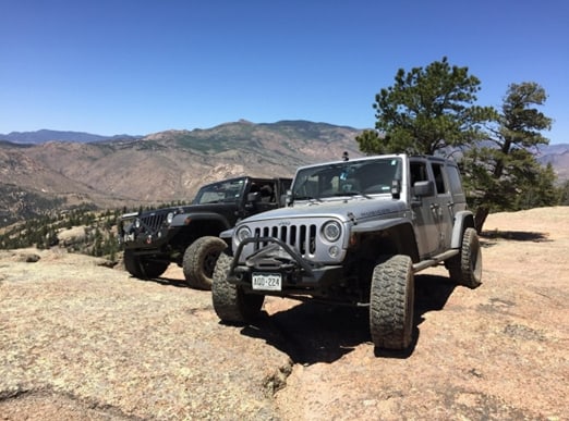
Patrick McKay is a board member of Colorado Offroad Enterprise (CORE) and Colorado Offroad Trail Defenders.
The author’s Jeep on the currently open section of the Hackett Gulch trail in Wildcat Canyon.
In September 2022, the Pike San Isabel National Forest (PSICC) in Colorado published the long awaited final decision for its controversial new travel management plan. The final decision closed approximately 123 miles of currently open motorized routes, plus multiple other routes that were temporarily closed under previous actions that will now be permanently closed. While this amounted to only a 4% net reduction in total open route mileage, these closures were disproportionately concentrated in the three ranger districts closest to the front range cities of Denver and Colorado Springs and affected several of the most popular four-wheel-drive trails in the forest. Some of the closed routes had been featured in published guidebooks and regarded as destination trails for decades, yet the Forest Service deemed them to have no recreational value and closed them. As a result, the quality of motorized recreation opportunities in the region has been severely diminished.
The motorized recreation community in Colorado is extremely disappointed with this outcome and feels that our interests were almost completely ignored throughout the entire travel management process, which was driven from the start by extremist environmental groups and anti-motorized activists within the Forest Service itself. The Forest Service based its route designation decisions solely on inaccurate data that was gathered without public input in the 2015 Travel Analysis Process and on secretive ranger district input that was never disclosed to the public. All public comments that challenged the factual assumptions underpinning the forest’s analysis were ignored. While motorized advocates managed to save a handful of minor trails through the objection process, the Forest Service dismissed the majority of our objections regarding the most popular trails subject to closure. We were left with no choice but to challenge this flawed decision in court.
On February 14, 2023, Colorado Offroad Enterprise (CORE), of which I am a board member, filed a lawsuit challenging the forest’s decision to close 12 specific road segments. The complaint primarily focuses on five roads in Wildcat Canyon along the South Platte River, as well as seven other roads in the Kenosha Pass, Fairplay, and Rampart Range areas. You can download the complaint here and all exhibits filed with it here.
Our lawsuit is only the latest chapter in the long running controversy over the roads in Wildcat Canyon, the history of which I have described in a past blog post here. It is sad it has even come to this, as this situation was supposed to have been resolved back in 2004, when the Forest Service issued a decision allowing these roads (which had been temporarily closed since the Hayman Fire in 2002) to be reopened under county jurisdiction.
That decision was intended to be a compromise that would allow motorized users to continue using these popular trails while ensuring that they would be maintained to avoid negative impacts to the South Platte River. While easements were quickly granted for the roads in Teller County, the ink on the decision was barely dry before a group of activist staff within the South Park Ranger district (including the current district ranger) began working to undermine the deal. They delayed and ultimately thwarted its full implementation by convincing the Park County government to withdraw its application for an easement in 2015, after the South Park Ranger District had stonewalled it for seven years.
The result was that only half of the Wildcat Canyon trail network was reopened, while the other half in Park County remained closed, with its two major loops severed. While the roads in Teller County were well-maintained by motorized groups, the roads in Park County deteriorated because the Forest Service refused to allow any maintenance on them while their status was in limbo, even though they continued to be regularly driven by members of the public who were unaware they were closed at the county line. Those negative impacts were then cited as reasons to decommission the routes in the travel management process.
As documented in our lawsuit, the same activist Forest Service employees worked to keep the forest from conducting any NEPA analysis on reopening the roads in the travel management process, ensuring that the ultimate decision to decommission them was predetermined. They also made multiple attempts to illegally decommission and obliterate the roads while the travel management process was still pending, being stopped only when other Forest Service employees pointed out their plans were unlawful. In the words of one such employee, “If our leadership wants to know why the motorized community does not want to cooperate with the forest service, this is a great example of why they don’t trust us. I don’t blame them for their outrage.”
One of the central themes of our lawsuit is the way the Forest Service abused the Travel Analysis Process (TAP) to generate unsupported and blatantly false route data which was then used to determine route designations in the travel management process with no public input allowed. According to Forest Service policy, the Travel Analysis Process is supposed to be a separate process from travel management. It is intended to generate baseline data that can be used to inform future travel management processes, not dictate their outcomes. Forest Service policy requires rigorous public involvement in both stages of the process, and specifically requires that the public be allowed to be given input in actual route designation decisions.
In the case of the Pike San Isabel National Forest, each ranger district produced its own travel analysis report around 2015, in which they assigned a range of risk and benefit scores to each route segment evaluated. These scores, which included things like recreational use benefit and wildlife risk, were based largely off of GIS data and the personal knowledge of district staff. These scores were later run through a formula to determine the ultimate designation of each route in the travel management process, with high value routes being retained as part of the “minimum road system” and low value routes being closed.
Each travel analysis report was subject to a 30 day public comment period which was not widely publicized and received only a handful of comments, in contrast to the thousands of comments received during each of the comment periods for the travel management process. Because of the forest’s failure to seek the input of motorized recreationists who actually use the trails, the many inaccuracies in the travel analysis reports were only discovered during the travel management process. Yet the forest chose to ignore all public comments challenging route designations based on inaccurate travel analysis scores, stating that decisions based on the TAP scores were not open to revision. Moreover, any route-specific recommendations included in the TAP reports by ranger district staff were automatically adopted in the preferred alternative regardless of their merit, and all public comments calling for different outcomes were ignored.
As argued in our lawsuit, the PSICC essentially treated the TAP reports as a dispositive travel management decision rather than a preliminary information gathering step, and then attempted to unlawfully “tier to” those documents to avoid having to conduct any real NEPA analysis of the impacts of individual routes in the travel management process. District staff were able to use the TAP scores and recommendations to largely predetermine the outcome of the travel management process, in blatant violation of NEPA and Forest Service policy. In the case of the roads in Wildcat Canyon, activist district staff manipulated the process by giving the roads blatantly false recreational benefit scores, ranking them as low benefit despite explicit findings in two prior NEPA processes that these roads had extremely high recreational value. Most of the other roads cited in our lawsuit were likewise given absurdly low recreational benefit scores, dooming them to unjustified closure.
The proper way for forests to determine their “minimum road system” (MRS) as required by the Travel Management Rule has always been a murky question with no clear answer. The PSICC claimed in its decision that the MRS was essentially determined by the TAP, even though Forest Service policy states that it is determined by the travel management process. Should our case go to trial, it will be (to the best of my knowledge) the first time the extent to which the travel analysis process can be relied upon for travel management has ever been litigated.
We believe it is clear that the PSICC violated NEPA and NFMA in multiple significant ways, not the least of which involved road closures in Wildcat Canyon that the forest itself had previously determined would violate the forest plan. As we know from internal emails we received, even some Forest Service employees considered the shenanigans the forest was trying to pull regarding some of these roads shameful.
I’m interested to hear the thoughts of people in this community on the forest’s actions here. The underhanded way in which certain activist employees were able to rig the process to close a number of highly prized motorized trails should be concerning to all. Legalities aside, the forest’s actions have caused a total loss of trust within the motorized community that will make it considerably more difficult for them to obtain our cooperation in the future.
 There are many AGW-Climate Change philosophical differences that are out there that may influence forest planning. I’m sure there are more that readers can add. I’ll use “you” to mean a forest or other planning entity.