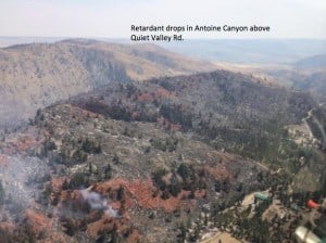
All’s quiet here at home, which gives me time to web surf. The Carlton Complex fire in central Washington is heating up again (temperatures > 100 with humidities in the teens). Inciweb posted this picture of aerial fire retardant lines.
Note the fire crossed the retardant lines, i.e., there is burned vegetation on both sides. Note that the fire didn’t burn the metal-roofed buildings and stopped where the private land had been cleared earlier of shrubs and trees.
But at least we tried!

Here is a view of where a stand was made on the Rim Fire. I tried to center the map on the center of the long fireline(s) protecting the community of Pine Mountain Lake. For about a week, they needed the tanker drops, engines and handcrews to blunt the daily assault of a new creek watershed being torched every morning. The cold and dry air flowing down the canyon each morning pushed the fire further downstream. There was nothing else they could do, as each creek did its “chimney” thing, each day. It was like fighting a brand new fire, each day, as it roars out of the canyon. The strategy worked pretty well, as evidenced by the aerial view. Zoom in and look around to see how they did it.
https://www.google.com/maps/@37.872454,-120.1487543,7195m/data=!3m1!1e3?hl=en
I was up on the Umqua-Willamette divide this weekend. The Forest Service has a lighting fire up there.
On Friday aftenoon they had a helicopter working on it pretty hard. On Saturday they seem to let it burn, with lots of people driving around. I guess they had it under control. I hope so.
Not all of our eyes are trained to see the goats on the hilltop. Please circle and note what your mentioning and repost. Thank you. Fire laymen.