Region 5 is working on a hazard tree decision for certain burned areas on certain (9 total) Forests with wildfires. It sounds like they are looking toward doing one EA per zone. This seems like an interesting experiment to see what can be standardized and what is best done at the zone or forest level.
Here’s a link to the documents. From scoping letter.
I am writing to inform you of the opportunity to provide input on the R5 Post Disturbance Hazardous Tree Management Project in the Forest Service Pacific Southwest Region (Region 5). Due to the time-sensitive nature of the proposed hazard tree removal, I am requesting your input on the proposed action briefly described below within the next 21 days, by November 15, 2021, to ensure your comments are fully considered during this public scoping opportunity.
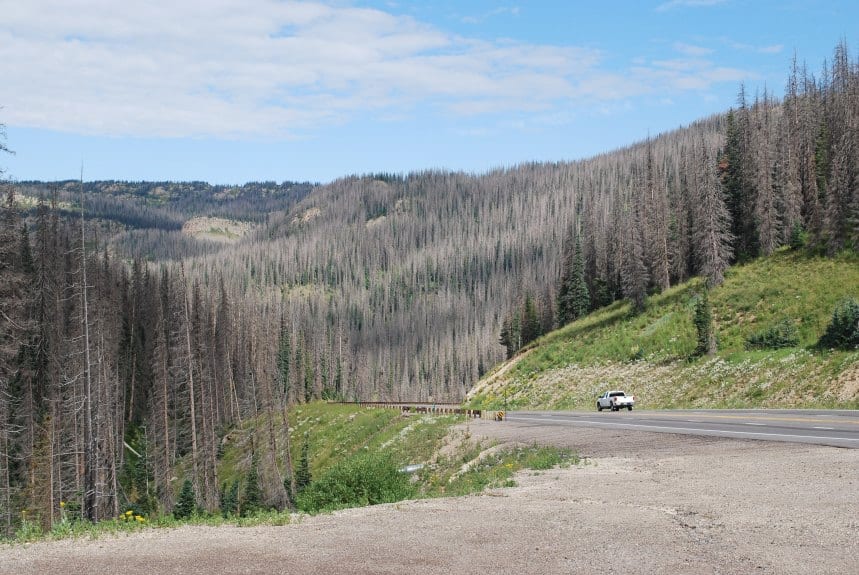
The record wildfire years in 2020 and 2021 in California have resulted in fire-killed or damaged trees that pose threats to public health, safety, and property. The R5 Post Disturbance Hazardous Tree Management project includes hazard tree felling and removal, as well as removal of downed woody fuels resulting from hazard trees (slash), to reduce public safety hazards along portions of roads, trails, and near facilities (campgrounds, trail heads, Forest Service offices). We have identified a need to expedite analysis and decision making related to this project, which includes activities that are not novel, and for which the effects are generally well-known.
Hazard tree felling, removal, and slash removal is proposed in specific project areas within the following national forests: Inyo, Klamath, Lassen, Mendocino, Modoc, Plumas, Sequoia, Shasta-Trinity, Sierra, and Six Rivers within the North, Central, and Southern Sierra sub-regional zones.
To initiate the scoping process for this project, a more detailed description of the proposed action has been developed to provide the public and other stakeholders an opportunity to review and comment on the proposal. A copy of the proposed action and associated maps can be found on the project website (https://www.fs.usda.gov/project/?project=60950).Based on the nature of activities being proposed, we intend to document the National Environmental Policy Act environmental analysis for these activities within separate environmental assessments for each of the three zones. The environmental assessments will be made available for public review during an upcoming 30-day comment period per 36 CFR 218.22 (anticipated January 2022). Ultimately, the Forest Supervisors will decide whether to implement the proposed actions on each Forest, implement an alternative action that meets the purpose and need, or take no action.
What’s interesting to me about this article about it from California Wild, compared to our Williamette discussion, is this idea..
In the past, wildfire-damaged hazard trees in undeveloped areas and along backcountry roads and trails are removed annually before the start of the summer recreation season. This reduces the hazard of trees falling on recreational visitors. And it also allows for the conservative retention of trees damaged but not necessarily killed or condemned to die by the fire. But the Forest Service no longer has the funding or staff to remove fallen or soon-to-fall trees on an annual basis and over the hundreds of thousands of acres that have burned in the last few years. Roughly 120,000 miles of trail, or about 75% of the National Forest trail system, already require some level of maintenance or repair. The massive hazard tree removal program proposed by the agency may lead to significant trail repair in some areas, but at the expense of the wilderness and recreational experience.
This is the “do it as they fall, but they can’t afford to” argument.
CalWild’s comments did not opposes hazard tree removal along roads, although this too has its drawbacks. Wide swaths of forest along some of the most scenic highways and roads in Northwest California and in the Sierra Nevada are proposed for clearing. Eliminating hazard tree removal taking place in sensitive wild places like roadless areas will help expedite the process. In addition, our comments requested that project not be expedited in a manner that bypasses the crucial public review, comment, and alternatives development process provided by the National Environmental Policy Act (NEPA).
California Wild also thinks that “swaths” or “denuding” along trials impairs “outstanding recreation values”. That might be in the eye of the beholder, especially in a burned over area.
They also say:
The Forest Service may seek an “Emergency Situation Determination” (ESD) from the Chief of the Forest Service to expedite the proposed project. This would enable the agency to sell hazard trees for their commercial value before they begin to rot, but it bypasses the pre-decisional objection process, which allows the public and other affected agencies to object to project actions and negotiate positive changes.
I’m kind of sympathetic to this.. the more detailed a project proposal is, the less need there is for two bites at the apple (comments and objections). It does draw attention to the objection “negotiation” process. I’ve only heard stories about these and would be interested in peoples’ experiences. For a different thread, though…
Some roads may be useful for clearing a corridor due to their location for potential strategic fire breaks…(plus for roads with faster speeds, it seems like it would help reduce vehicle/wildlife collisions.)
In fact, CalTrans has a plan about the former for state highways.
Overview
State highways extend through every county and range of elevation in California. Over 5,000 centerline miles of state highways are built in a rural setting of natural landscapes, including forestland, chaparral and grassland winding through mountains and along coastlines. Historically, active forest management of forests was discouraged in California, but this has resulted in unhealthy, overly dense timber and vegetation which increases wildfire vulnerability and decreases forest health. Drought has triggered widespread accelerated forest mortality.
Defensible space, in the context of fire control, is a natural or landscaped area around a structure that has been maintained to reduce fire danger. Through the Division of Maintenance, Caltrans prepared a Wildfire Vulnerability Analysis (2020-2030) which identifies the highway corridors that are a priority for fuels reduction to create defensible space. Fuels reduction projects with local, state and federal partners would reduce wildfire vulnerability to life, property and ecosystem services.
Defensible space can also mitigate the probability of wildfire ignitions originating from vehicles and travelers, reduce direct impacts to state highway assets when wildfires do occur, and maximize traffic flow for all modes of transportation during normal and emergency operations.
So roads as defensible space are a thing also, at least in California. Another reasons to focus on getting PODs delineated ASAP, IMHO.
Cue the doomsayers! It’s time for them to say “This is a giveaway to the timber industry!”
“Historically, active forest management of forests was discouraged in California, but this has resulted in unhealthy, overly dense timber and vegetation.”
When you don’t start out being objective and factual, it’s not going to go well. It’s equally likely that active management (suppression) of wildfires has resulted in unhealthy, overly dense timber and vegetation.
At least they seem to have learned the lesson from others’ mistakes that there is no categorical exclusion for roadside timber sales.
Or at least there wasn’t such a CE until the 3000 acre provision in the 2021 infrastructure bill (but I guess that one won’t fit this situation.)
I worked on one roadside hazard tree project where the slash was required to be “removed from the sale area”. This was decided by the fuels people on our Ranger District. The purchaser was able to find a firewood company to do all their slash work, in exchange for the generated firewood. It worked out well for us.
“Wide swaths of forest along some of the most scenic highways and roads in Northwest California and in the Sierra Nevada are proposed for clearing.”
I highly doubt that anyone is proposing actual clearcuts of all vegetation along those roads. What would be the “purpose and need” of such a project? There is also the fact that many slopes along those roads are not conducive to logging, being too steep, rocky, or sparse. Additionally, in Sierra Nevada National Forests, clearcuts are still banned and diameter limits still exist.
Hazard tree cutting within the Caldor Fire has begun on Highway 50. Will there be an injunction? We’ll see, soon enough.