My current article/editorial on Global Warming and Oregon Wildfires was just published: http://nwmapsco.com/ZybachB/Articles/Magazines/Oregon_Fish_&_Wildlife_Journal/20220401_Global_Warming/Zybach_20220401.pdf
This article documents predictions of western Oregon wildfires over the past 30 years, including newspaper and magazine articles, photos, maps, websites and radio interviews. I’ve posted the illustrations, table, cartoon, and captions below.
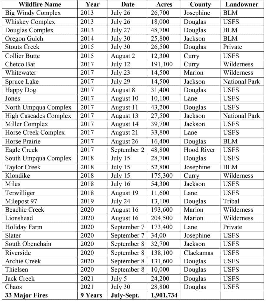
CONCLUSIONS: 1) From 1952 until 1987 there was only one (!) fire in excess of 10,000 acres in western Oregon — during the past nine years alone, there have been 33 (!) such fires;
2) Of these 33 wildfires, 30 began on, and were mostly confined to, federal forestlands;
3) These fires have been clearly predicted for more than 30 years, based entirely on changing federal land management practices, and have nothing (“zero”) to do with Global Warming — fire seasons (July and August) have remained about the same for more than 200 years;
4) These fires remain predictable into the foreseeable future and could be largely mitigated by a return to active management of our public forests, beginning with the salvage or treatment of millions of highly flammable snags remaining from these fires on federal lands.
Bottom Line: To fix this mess, in my opinion, we just need the legal ability to return to the active management of our public forests.
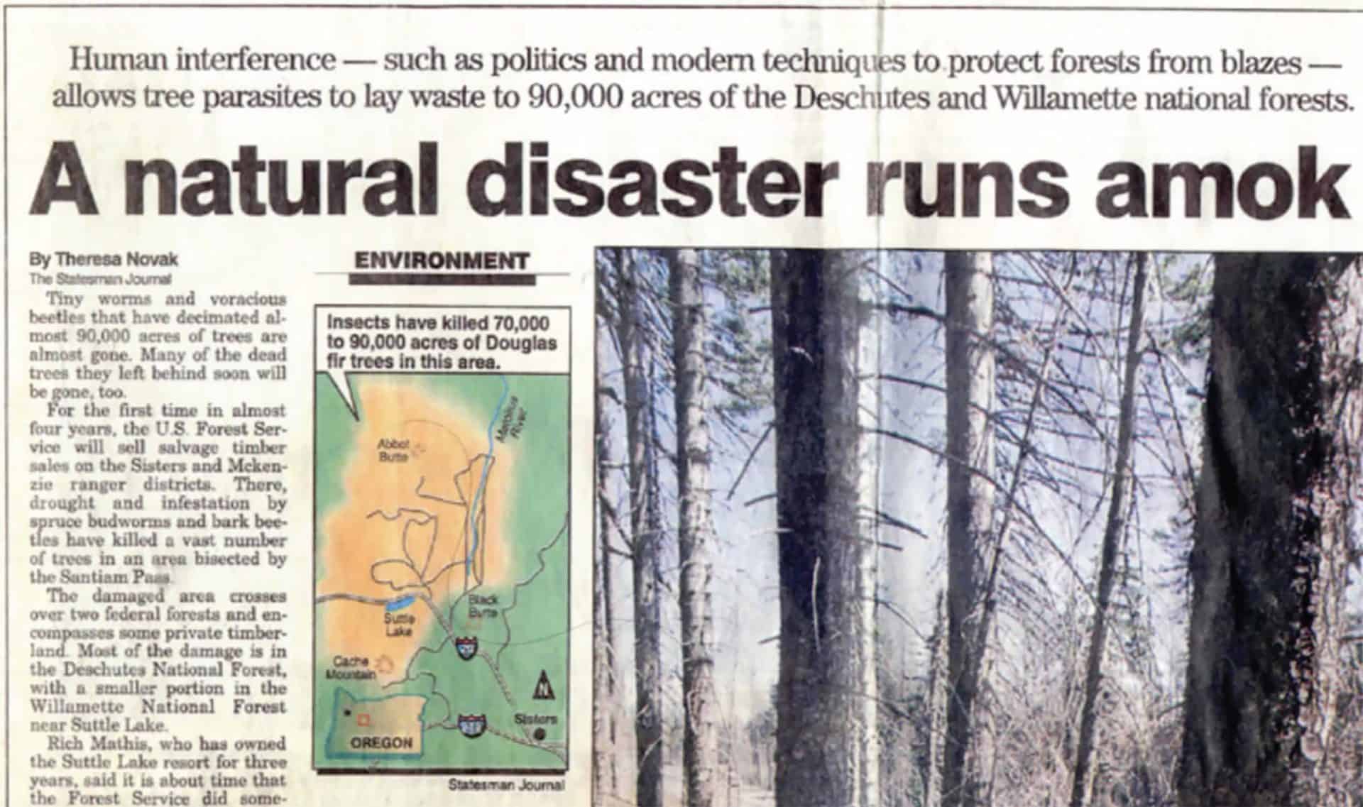
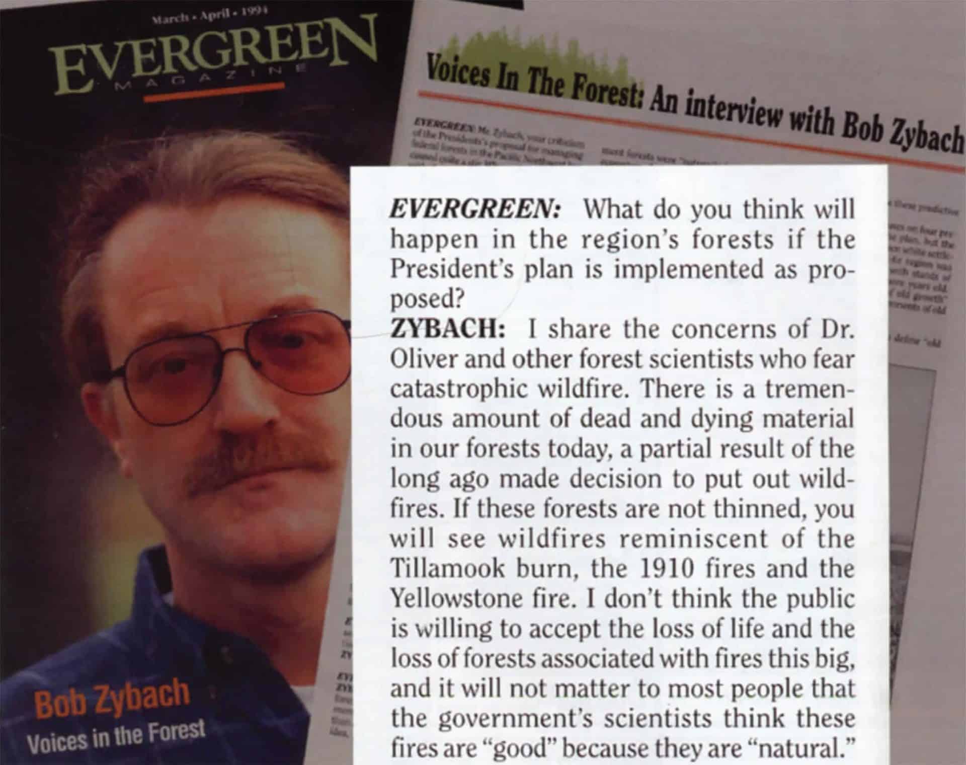
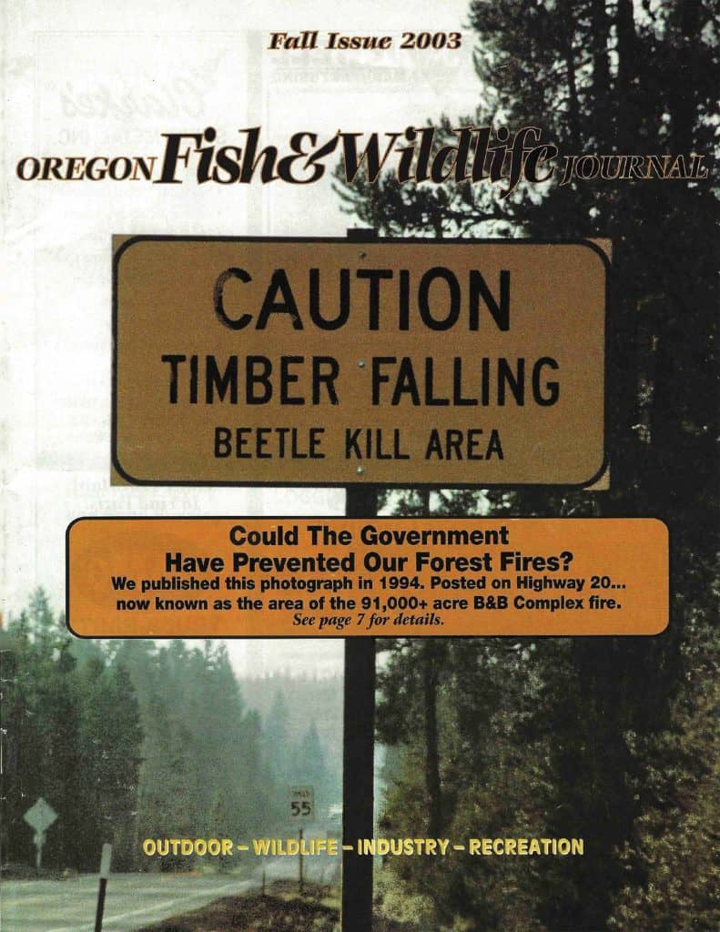
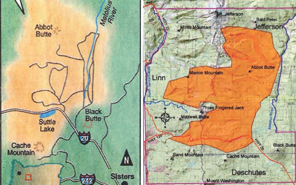
Figure 3. Fall 2003 cover to Oregon Fish & Wildlife Journal, references 1994 Highway 20 beetle-kill as background to current article on B&B Complex.
Bob.. some thoughts
1. It seems to me that this is also an argument for the most thoughtful design of fuel treatments and PODs that our best folks can dream up..
2. Because the infrastructure won’t be able to keep up with large pulses of tree deaths..even if the social license was there, and I don’t see it going that way. But who knows?
3. I don’t think 0 is a good amount to think these fires are caused/exacerbated by human factors influencing climate change (AGW).
What I like to do is do a thought experiment.. what if it were 20%. 50%, 70%? How would that change the way we manage forests now and into the future?
What I usually come up with is that given AGW, or regular climate change, or invasive species, or ?? we don’t know that the past will be prologue; but it’s still the best we can come up with. So monitor and adapt.
Anyway that’s my two cents.
Hi Sharon:
You won’t be surprised that I had to Google PODs, and then add “forestry” to the Search to learn about them. I would think that they are similar to my long-standing promotion of named subbasins as the basis for forest management, whether wildfire, prescribed fire, logging, recreation, or forest management. Ancient travel routes, logging roads, and modern highways follow ridgelines and riparian areas, and most plants and animals spend their entire lives within these confines. Streamside buffers and ridgeline plantations have greatly affected wildfire behavior in recent decades, and the cost of responding to these events is exacerbated by reduced access, fewer and lesser firebreaks, and accumulating fuels, in my experience.
There is no way the existing infrastructure can physically — much less economically — deal with the great numbers of snags created on federal lands in the past 30 years, but the least we could do is manage the snags along historical firebreaks, adjacent to private properties, or along travel and powerline corridors. As in the past, before these fires started becoming a regular problem.
Human effect on the climate of western Oregon may well be greater than 0, but predictions of these wildfires — which have been accurate for decades — have been based entirely on ownership patterns and management actions. There was 0 need to consider any potential anthropogenic Global Warming in making these predictions. For this region, it is not a noticeable concern and seemingly has little or nothing to do with these fires. If it is even taking place, whether CO2 is a factor or not.
So far as forest management into the future, our most valuable timber tree is Douglas fir, which is probably 90% of conifer volume in western Oregon, and which exists in a wide variety of climates from Mexico to Canada, and from the Pacific Coast to the Rockies. Adaptable, just like people, fish, birds, and viruses. The main problem is having way too many of these trees (“contiguous fuels”) across the landscape, allowing for crown fires and resulting millions of snags. The first problem is keeping our existing roads and trails in order, and systematically removing volatile fuels in sensitive areas, in my opinion.
Sorry about PODS.. wonder if we should have a glossary?
My advice is to avoid them whenever possible, or to include their meaning in parentheses whenever their use is unavoidable, or at least convenient, with their first mention. I continue to believe that the overuse of acronyms has been one of the real barriers for involving the public in forest planning. Not the only one, but a pretty constant problem. In my opinion.
Sharon:
Part 2. I think the strategy of “Monitor and Adapt” should be the focus of all of the forestry and wildlife modelers working for agencies and universities these days. Even Growth & Yield models from the 1940s would have been improved with this focus, as Weyerhaeuser discovered with their Mt. St. Helens properties. Also what the USFS actually did in concert with industry in the 72 hours following the Columbus Day Storm.
Bob’s assertion that the current upward trend in wildfire has nothing to do with climate change does not fit with what others who have studied the topic extensively are saying. I find it off base, but no more off base than say George Wuerthner who has repeatedly written articles saying that the upswing in fire behavior and acres burned is entirely due to weather and fuels are irrelevant.
Putting the climate change subject on hold for a moment- Bob brings up the topic of salvage logging. While I am not in favor of entering wilderness areas to salvage log, I think the current paralysis is dangerous to the future of our forests. If there were too many green trees on the landscape to begin with, then there will be too many dead trees on the landscape after insect attack or wildfire. We need post-disturbance fuels reductions in places like Bootleg Fire. If we can’t reduce fuels we will lose most or all of our reprod in the reburns that will surely happen. There is middle ground between getting rid of all snags and thinking we need to save every single one for the woodpeckers. Climate change makes active management more imperative.
There’s also the question of whether we should replant unsalvaged snag patches, when another wildfire is expected in 10-20 years. Lots of people want the burned areas replanted ASAP. I think we’ll be in more of a ‘triage’ mode, only replanting the areas that make sense, with lessened amounts of fuels. Of course, we could just wait for the re-burn to consume all that large woody debris, and start over, with damaged mineral soil.
Indeed, the answers are in the middle, and the timber management folks have reached their middle ground, regarding Federal timber salvage.
Larry: There have been three major reburns of the Kalmiopsis Wilderness since the 1987 Silver Complex. Local observations are that the Douglas fir snags on the north slopes are beginning to fall, creating heavy ground fuels. No trees left, but manzanita is flourishing. There has been no attempt to salvage or otherwise treat these stands, with the result being no trees and grossly altered “habitat” on north slopes. Also, the result of hundreds of thousands of acres of private and USFS lands during on the perimeter of the Kalmiopsis.
Hi John: I definitely agree about the “middle ground” — which would be a major step forward for the USFS, which is projected to salvage as little as 1% to 3% of the millions of snags created during the Labor Day Fires. One thing that made these fires so destructive is the presence of USFS snag patches that have already burned once or twice in the past 20 years. And still, government reps are having Mexican and Guatemalan temporary workers planting too many trees underneath the standing snags. The State also dumped seed over 4,000 acres of new snags because the area was “too dangerous” for tree planters. Most everybody else gave up aerial seeding due to regular failures in the 1960s. Nobody used to plant underneath standing snags because that part is dangerous, as well as usually being a waste of time. In my experience.
https://www.gazettetimes.com/news/local/santiam-reforestation-efforts-underway/article_eae44d7b-4b11-5221-8361-f37027ef519a.html
https://www.fs.usda.gov/features/planting-new-hope-umpqua-river-basin
Note: Because of the presence of the Pacific Ocean and parallel orientation of the Cascade Range and coastal mountains, the climate of western Oregon has been remarkably stable for centuries and probably millennia. Fire seasons — including all major wildfires — for the past 200 years have almost entirely started in July or August, or occasionally late June or early September. Then Fall rains eventually extinguish them. The climate is the same on both private and federal lands, yet 90% of the major fires start on federal properties. There has been no apparent “climate change” effect on private lands, despite any experts that might be claiming otherwise.
Also, as one of the quotes from 1994 says “fires are good because they’re natural”.. but now most people think they are “unnatural”, that is influenced/exacerbated, by AGW. So some of the context has changed, but I don’t think anyone has changed how they feel about salvage.
Since the Forest Service has been winning a lot more often, in the Appeals Courts, it seems like the judges feel that the Forest Service has been ‘following the law’, regarding fire salvage.
Sharon- I much appreciate the forum you have created. You bring folks in the know together. Now- an observation, I find myself struggling at times to figure out what your acronyms mean. Like Bob, I am not familiar with PODs and I don’t know what AGW is either. I have long considered acronyms to be highly useful in speeding up dialogue within the very small circle of people who know what they mean. Outside that small group of insiders, acronyms are a barrier to conversation and the dissemination of knowledge. Other than the few acronyms that have gone mainstream like WUI, acronyms should not be used without first defining.
Many apologies, John, it’s good to hear from readers! Please continue to point out what will make it better for you. I will try to be more sensitive. In fact, since Bob had trouble finding PODS on Google (!). I will start a post specifically on the key website. Thanks again!
Thanks Sharon- Please tell us what AGW means too.
This is one that even I know! AGW is the acronym they gave to “Anthropogenic Global Warming,” or global warming caused by humans breathing and burning CO2. I used to joke that it stood for “Apocalyptic Global Warming” with the evaporation of the snows of Mt. Kilimanjaro and Florida going underwater — not to mention the mass starvations, human migrations, and skin cancers. When that didn’t happen, they changed the name to “climate change” and modified the horror stories to keep the cash flow happening. Now I think it’s “climate crisis,” or something, according to the Governors that I quoted.
I would like to know what assumptions folks are making when they talk about “reforestation” in this discussion – 500 trees per acre? 10 x 10 foot spacing? 20 x 20 foot spacing? The Umpqua is only planting about 200 trees per acre…
Hello Dr. Anonymous: Now you are bringing up the subject that is near and dear to me, and of great concern with what the USFS and Oregon Forestry are doing. I should probably post one of these articles to this forum, but here is a general response, with recommendations, on that question to the Labor Day Fires, and the second one is specific to the Umpqua NF: http://nwmapsco.com/ZybachB/Articles/Magazines/Oregon_Fish_&_Wildlife_Journal/20210320_Wildfire_Reforestation/Zybach_20210320.pdf
http://nwmapsco.com/ZybachB/Articles/Magazines/Oregon_Fish_&_Wildlife_Journal/20220101_Umpqua_Reforestation/Zybach_20220101.pdf
Very interested in your thoughts! And kind of curious why you are hiding your identity . . .
Here’s a paper I ran across last week, one of many recent papers suggesting that wildfire is associated with climate change: https://www.science.org/doi/10.1126/sciadv.abm0320
The science is pretty simple, warming increases the water vapor holding capacity of the atmosphere exponentially (it’s not a linear relationship), increasing the evaporative demand by the atmosphere, drying out vegetation. It’s been getting warmer over the past 30 years, measurable and true. Fire seasons are a lot longer than than they used to be, measurable and true. Nighttime temps are a lot warmer than they used to be, measurable and true. These are all critical factors for wildfire that are caused by climate change.
The fire behavior triangle: Fuel, Weather, Topography. Sure, fuel is part of it, but weather is super important and its importance increases the more productive the system is.
National forest lands generally receive more recreation visits (and associated human ignition sources) than private and state forestlands. Most national forest lands also get more lightning (natural ignition sources) because they are higher elevation than private and state forestlands. So is it surprising that 30 out of 33 large fires started on federal forestlands?
I think this blog should adopt a policy of not allowing harassment or questioning of commenters who wish to stay anonymous. People should feel welcome to comment and participate regardless of whether they choose to use their own name, a pseudonym, or simply remain anonymous.
One benefit of allowing anonymous posts is that folks who are agency staffers can post their views without fear.
Hi John: I have personally stopped commenting on a number of blogs over the years because they were being over-run with trolls using pseudonyms. The daily newspapers used to require that people use their real names and addresses in order to be published. There is little or no personal accountability for people hiding behind a fake name. That being said, I think the use of pseudonyms on this forum has been kept to a minimum and most contributions have been reasonable. “Anonymous,” for example, appears to be knowledgeable and reasonable and there is probably a good reason (current USFS employment? active warrants?) for wanting to be unidentified. So, curiosity (“questioning”) seems totally reasonable — not sure why you think that is “harassment.” Personally, though, if there is to be a “policy,” my preference would be full disclosure and accountability.
The “surprising” thing is 33 major fires in nine years!?! So, of course, my answer is “yes.” Very surprising. And largely preventable.
What I think is fun about Anonymous is that there are obviously different folks with very different ideas. So I may think what an Anonymous is going to say based on A#1, but they are really A#3 and go off in a different direction. So I think it makes me more open-minded, which I think is always a good thing. And there are particularly interesting and reflective Anonymouses (i?) and I wouldn’t want to lose their perspectives.
Hi Sharon: I mostly agree — I’ve enjoyed the Comments and feedback from the Anonymous (Anonymi?) and the unidentified personas in this forum, partly because they contribute and seem to have good reason(s) for their anonymity or pseudonyms. It’s just when the practice gets out of hand and anonymity is used as a shield for attacking others that is discouraging. I always feel better when they stay on topic, have interesting things to say or questions to ask, and are also willing to state why they aren’t using their actual identity — as above.
We don’t seem to have much of a troll problem here (and the ones I remember weren’t anonymous). I think we can thank the fact that this is a manageable-sized blog, and that Sharon manages it well.
Regarding the conclusion that federal land management is the problem, I think you can only get there if that’s what you want the answer to be. Thanks to those who have pointed out that this ignores much research pointing towards AGW (I learned a new acronym), and that federal forests and private forests likely have other reasons for different fire outcomes.