Dear TSW Readers,
This is the beginning of a new approach- DIY analysis and data interpretation. I will present my data and findings, and you get to reanalyze them and come up with your own conclusions.
Here’s what data I asked for from the FS- I asked for WFU (Wildland Fire Use) acres by year. The nice folks at the National Press Office sent me this handy table, which includes prescribed fire, mechanical treatments, and other. Here’s a sample:
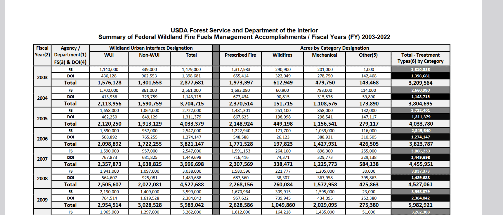
Here’s what “other” is..”Treatment Category that describes work involving the use of chemicals, grazing, or biological methods to achieve Fire Management Plans objectives.”
So I made an Xcel spreadsheet of the WFU acres, and added the NIFC total acres for that year.
Then I subtracted the WFU from the NIFC total for each year, to get what I call “unwanted wildfire acres.” Here’s the Xcel spreadsheet. It’s altogether possible I did something wrong, so perhaps you all can check it.
Here’s what I plotted.
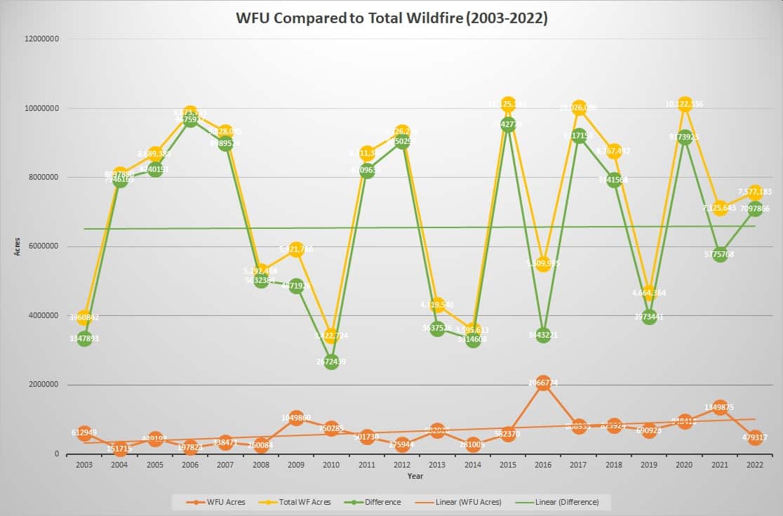
If the data are accurate and my spreadsheet used the correct data, then the fitted line for unwanted fire acres (UWF) is almost straight from 2003 to 2022. Which means that there has been little or no increase in unwanted acres burned through time. Which is quite against what you read in the press, so check my figures!
If my data is true, here is my narrative. Despite everything we’ve read about increased fire weather and so on, our fire suppression folks have done an amazing job at keeping the unwanted acres burned basically the same for the last 20 years. They deserve a great big thank you from all of us.. oh and the correct policy solution is to… Pass The Tim Hart Act!!!!
I’m sure there are other interesting things that could be found in both the FS accomplishment table and the WFU/UWF (I think UWF should be pronounced “oof”.. just kidding). And what happened in 2016 where the WFU was almost as large as the UWF acres?
It is REALLY hard to see the subtleties of these graphs (I give up on viewing the tables) on just an iPhone. But, if your regression analysis is correct – Holy Smokes, what an eye popping visualization of the past 20 years! Very fine work!!! Maybe we have been “spun”….? 🤣🤣
I couldn’t figure out how to get rid of the numbers for each datapoint without starting over. Relearning Xcel has not been easy.
I don’t know if you are exactly on the right track here. It may take a little more research. Sometime back in the 2000’s, they made it where if you could claim that if a wildfire created beneficial effects, it would be counted as resource benefit acres. It was one of those games that was created for the FS to get extra acres to show. This does not mean that these fires were necessarily WFU fires. They may have just been your run of the mill wildfires, but they burned at a moderate intensity so that they could be claimed as beneficial. This could be a major part of your analysis here. Perhaps someone currently working in fire management could help provide some clarification on this.
I vaguely remember this as WFURB (Wildland Fire Use for Resource Benefits) May have even had a different account code separate from suppression. But when a WFURB was no long meeting ‘resources objectives’ it had to be converted to a ‘suppression wildfire’ incident and could not be returned to a ‘beneficial’ fire. There was a time there in the post National Fire Plan (~2000 ish) when leadership started refining Fed Fire Policy to define ‘Wildland Fire’ as either Prescribed Fire or Wildfire. Wildfire could be used to meet’Resource Objectives’ identified in the Land and Resources Management Plan.
So Dave, sure we need to understand whether the numbers are based on intention ( we are deciding to do this) vs. post fire analysis (this was a good thing for these acres). The FS might want both sets of numbers for different reasons.
But I was only interested in the characterization of increasing wildfire acres and using acre data to parse out the impacts of anthropogenic climate change. Meanwhile there’s smoke (bad) regardless of impacts to biodiversity, which has heightened concerns in the last few years. So good fire with bad smoke. Outside our community, there seems to be an apocalyptic framing of wildfire that I don’t think the data supports.
I think you are doing well at sorting this out. I agree that the larger acres are being used by some, in a very simplistic way to point to and say “this is because of climate change”. When, in fact, the story is much more complicated than that. Over the last 15-20 years, there have been incentives to burn more acres if it was seen as resource benefit. But I have seen a lot of areas that were intended for resource benefit, that certainly did not look to be beneficial to the resource. Some of those areas, I had a hand in the decision making. Things don’t always work out as intended.
I agree with you that a lot of people are predicting doom and gloom. There are people coming from different perspectives, that are utilizing the threat of climate change and the resulting increase in wildfires, to bolster their own agenda. This would also include the timber industry which is using climate change to justify more timber harvesting to prevent forests from burning up. The environmental groups are saying it’s about sequestering carbon and the trees are better off standing. That this addresses climate change and wildfire occurrence in the long run. Someone has to sort through all of this stuff and get to the truth of things. I think you are doing some good work on that.
Great place to start Sharon, but it seems ‘acres burned’ comes up short in telling the bigger story through space and time. Both ‘suppression wildfires’ and ‘wildfires managed for multiple objectives’ (resource and protection objectives) can have intended and unintended outcomes and sometimes these initial outcomes seem ‘bad’ at first but over time through monitoring and research prove to be ‘good’ for the biodiversity of the landscape.
Then again, the loss of ‘temporal diversity’ has massive impacts on western forests, when old growth is killed. Additionally, if the burned lands include private timberland, that idea is accentuated through their salvage logging activities. Many realities of wildfires aren’t seen by the public. Most people don’t walk through burned forests, and don’t see the high fire intensities of today’s firestorms and re-burns.
I’ve also wondered about this ‘loss of temporal and spatial’ diversity. How/who/what should we measure and monitor and for how long? If thinning / logging in MOG in highly vulnerable watersheds is a non starter what management options do we have where we can be more transparent with the public and local collaborators?
Those are good questions.. My impression is that it depends on what anyone thinks is good or bad.. Some things seem generally bad, like towns burning up or soil or watershed problems or decreased habitat for endangered species.
And inherently wildfires can’t be managed down to the gnat’s eyebrow so having all good and no bad is unrealistic.
Being a simple person, I’d like treed areas to have trees come back and protect soils and watersheds. Monitoring, in my mind, should focus on things you would take action on if monitoring showed something. A good example would be regen.. monitor for naturals and if you don’t get enough (value judgment) then plant. So monitoring would be important.
I’ve been mostly thinking of fire management plans for engaging the public, but the point you raise about post-fire needs and collaboration expectations for what happens post-fire and how long should probably be a part of that.
The firestorms and effects are the same now as they were in the past, the only distinction is in the past we suppressed fires to keep those incendiary effects small. Now, bigger bangs for bigger bucks; climate change, resource benefit, diverse landscapes, fuel reduction (?) and any other lame-brain excuse the fire org can think of…..
No, the effects are not the same. There are new Google aerial images of the Dixie Fire out now. There were very high intensities, right where I expected them to be, in the (relatively) unmanaged true fir/lodgepole zones. If Lake Almanor could not stop the fire, there is nothing us humans can do to stop wildfires. Yes, we can alter fire behaviors and fire intensities, but tactics and safety have helped to increase acreages, IMHO.
We still need to use the proper tools in the toolbox for site-specific actions, to do the “greater good”.
Yes they are Larry, if you go back to the 1960’s, extensive fires in Oregon absolutely incinerated the soil. No, they weren’t hundreds of thousands of acres, but 3,000 – 4,000 acres. Those effects on that local site were catastrophic – just a measure of scale difference. As I said, back then, fires were full, front-on, direct suppression, one foot in the black.
Hi Jim: My crews planted many of those locations and the effects on soil were only transitory. Sun, water, and root growth seemed to overcome burned soils in a year or two. Compacted landings seemed a greater problem so far as tree regeneration and growth, but even those problems seemed to be resolved in a few years. Would be good to see a long-term study in those locations!
True Bob; my point was when these “smaller” fires burned, their results were just as catastrophic. I wasn’t there in the ‘60’s but was in the late ‘70’s reforesting acres burned in the ‘60’s. When green trees are incinerated to the lower main stem, it’s burning hot! I saw that on the fireline in the 70’s, both East and West Sides.
I recognize larger fires have more cumulative effects, and many issues blown out of proportion are transitory but intentional burning out large tracts for convenience is not being the best of forest managers!
Bob, I thought we were supposed to rip landings prior to planting.. didn’t that work in the places you are talking about?
Hi Sharon: That may have been a USFS requirement. I mostly quit doing government contracts in the early 70s, and the industrial landowners and tree farmers I contracted with from then through the 80s never scarified a single landing that I can recall. In compacted heavy clay soils planting was very difficult and almost always had to be repaired later that year or the following. But relatively small and very accessible locations made the repair work quick and easy. Mostly wind and animals.
On salvage sales, it wasn’t a requirement unless I decided it was needed. Also, there was an acreage limit in the contract, depending on the size of the entire project area. It was rare when I would require a landing to be ripped.
I once saw where a different Timber Sale Administrator had located a landing in a gully (bad move), then required ripping (worse move). The next winter had a flood event, and the entire landing washed away.
I wish “somebody else” could have done the analysis with the internet sites available for policy issues when the Forest Service was doing forest planning.
2003 was when the persecution of the Wenatchee Four was in high gear by Senator Cantwell. Right or wrong, her personal attacks resulted in an “inflection” point in 2003 as burned acreage jumped substantially and remained high.
I don’t think most people recognize how many Federal firefighters left the firefighting to somebody else. Just a few years ago, the Governor of Oregon noted that Federal firefighters were missing when it came to fire staffing. Well, I am glad somebody noticed.
As others have mentioned the real issue is fire severity effects. I am sure you saw the graph from 2017 based on RPA 2020 data that showed tree growth on National Forests heading negative.
I poked around the various RPA publications and the Rocky Mountains are NEGATIVE in tree growth. The Pacific coast states of Washington, Oregon, and California were still positive, but after the large Oregon and California fires in the early 2020’s I am pretty sure that the western National Forest are running below sustain yield levels due to fires and insects!!! Congrats to the environmentalists from saving our forests from over cutting, to bad they are little concerned about over burning.
If you can get NIFC to prepare you a map of the large fires since 1986 that is a very interesting map, showing the HUGE amount of destruction that has occurred on public lands since that time.
The Cal Topo web site shows fires since 2000, but misses the 1980’s and 1990’s.
That map with fire severity shown, will pretty much tell the entire story of the devastation of our public lands over the past 40 years.
Hi Vladimir: I have been doing this very thing for the large fires in western Oregon from 1952 to the present — and you are right, 1986 is the fulcrum year. This information is regularly published, with maps and tables, in a rural statewide magazine with a circulation of 10,000 mostly rural people and businesses, and all of the State’s elected officials. I also regularly supply this information through a couple of regional radio shows with a large listenership. Also, I have a PhD in the topic.
You won’t be surprised at the strong interest I get from USFS, BLM, State Foresters, and my alma mater, OSU Forestry! That’s right, none. They are too preoccupied it seems with computer modeling, climate change, and making colorful maps to actually become involved in common sense forest management and wildfire mitigation. At least that’s according to their press releases.
Predictable, pathetic, and amazing that a stop wasn’t put to this senseless damage to our forests, wildlife, and rural communities long before now. We were shown and trained how to avoid these problems (pre-1987), but somehow Clinton knew better, and now this. And they seem determined to continue.
“Acres burned” is not a good measure unless it is refined. An acre of burned grass or shrubs rarely creates a problem and often rejuvenates favored vegetation. An acre of burned invasive juniper is probably a good thing, whereas an acre of burned invasive Douglas fir or yellow pine is probably not good. Likewise, there is a big difference in burned Douglas fir reprod and burned mature timber.
These differences are basic and relatively easy to measure. Why isn’t this done? Subsequent analysis of wildfire management costs that are fuel and value dependent would seem to be a lot more useful if preceded by some basic stratification along these lines.
If you look at the research that folks like Alan Agar and Mark Finney have done, there isn’t a linear relationship between fuels acres treated and wildfire. You have to treat at least 20-30% of the landscape for it to have any effect on fires. Ideally you would do this in strategic places if they can be identified. So the question is where has there been enough treatment done to have a measureable impact on fires?
I’m not sure if anyone will see this since these threads tend to go cold after a few days or when new topic get all the attention (though this thread was referenced for a current thread to prove a point) 🙂
This is an interesting thought experiment here but maybe too simplistic and/or show the complex nature of teasing out raw data.
Why substract out WFU wildfire data for the total wildfire just because we consider it useful when looking at Wildland Fire Fuels Management Accomplishments? There are a ton of things we do fighting wildfires the contribute to the final outcome of wildfire acres. We set containment boxes/lines based on conditions and resources. So why substract out WFU data and not tactical burn acres, or we don’t have the resources so this part of the fire will just burn until we do have the resource/plan. And on and on. I think it is a little too simplistic/arbitrary/capricious to do so.
If you don’t subtract out the WFU data then look at it then there is an increase over 2003-2022 and if you look at the whole for NIFC data 1983 to 2022 then the trend is very clear.
This approach reminds me of the “there is no hockey stick affect” by cherry picking the global temperature data from years past.
again we can do better.
While I am not a fan of WFU fires, during the summer months, I have to agree with you that there is a wide spectrum of issues around many WFU parcels. Politics and public attitudes are really big, right now, depending if you are in a red State or a blue State. While it might be easy to justify a decision made, early in the fire, the public might never forget one that went bad. Safety issues are usually good for “CYA”, if you don’t want to officially ‘let it burn’.
Not every WFU declaration is the same as the other ones. It’s not very useful to lump them all together.
I absolutely agree with you, Carl! My point was exactly what you are saying.. total acres burned really doesn’t tell us anything about unwanted wildfires. My memory is that in the 80’s we didn’t talk much about fire for resource benefits and now folks use it quite a bit.. in fact there’s a fire, I think, that’s been burning all summer.
I agree that it’s more complex, but using (total acres – claimed WFU) is no more simplistic than using (total acres). If I were designing a study you bet it would incorporate all those things in some way…
but then.. we’d all have to sit down together and start with “what questions need to be addressed and why”? I think that would be a good place to start.
The Park Service used to have a “Let it Burn” policy in the 80s. The Yellowstone Fires in 1988 changed that. It just seems to me there are too many variables to really make sense as to whether climate change has caused an increase in acres burned. Maybe it has. Maybe it hasn’t.
I agree with you Sharon, the media over plays the card of climate change is causing more fires, larger fires and more intense fires. The concept of why CC might be doing this makes sense, but does it really?
Kudos to you for taking a crack at it.