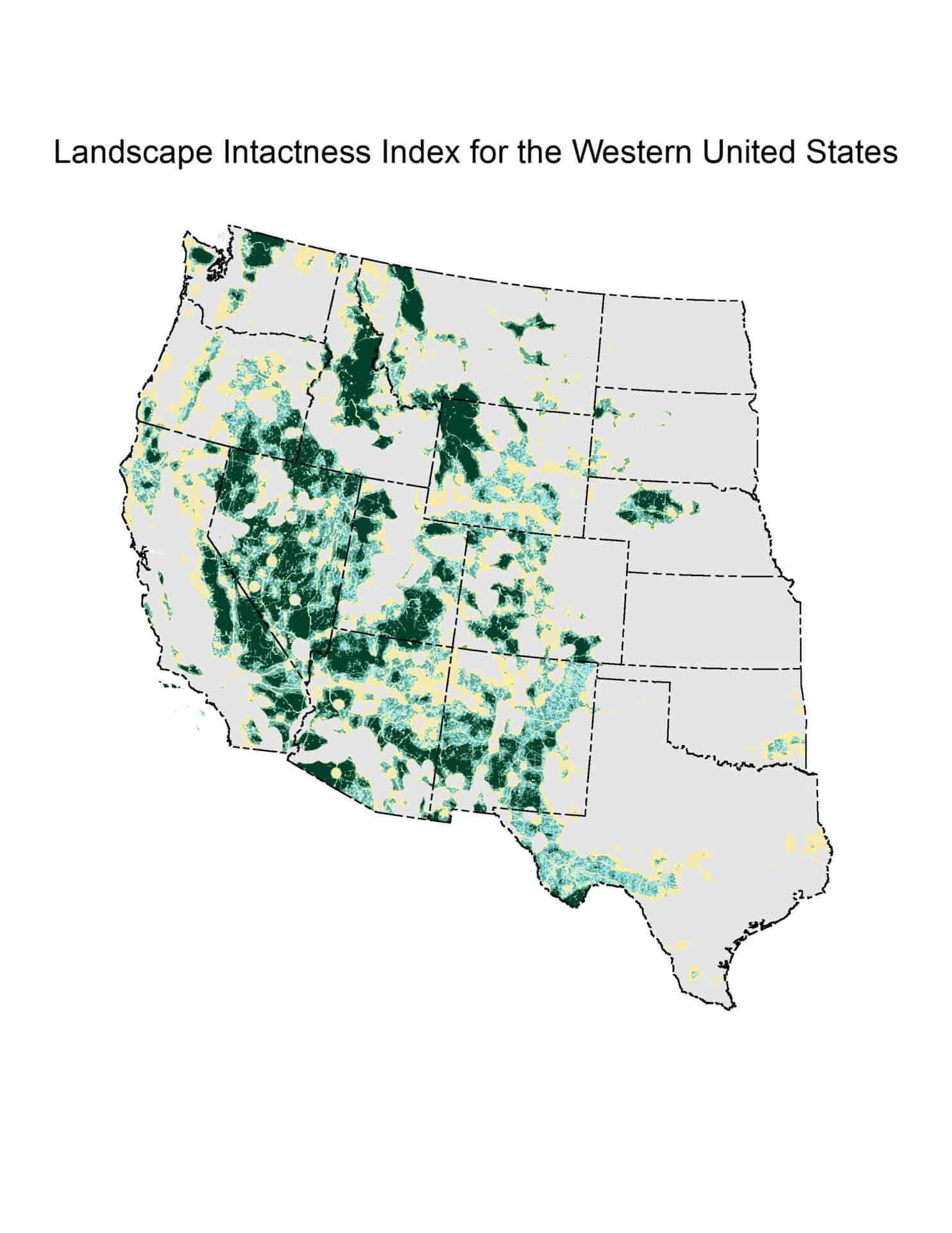
The second paper cited in the BLM Public Lands Proposed Rule is called “A Multiscale Index of Landscape Intactness for the Western United States.“.
Landscape intactness has been defined as a quantifiable estimate of naturalness measured on a gradient of anthropogenic influence. We developed a multiscale index of landscape intactness for the Bureau of Land Management’s (BLM) landscape approach, which requires multiple scales of information to quantify the cumulative effects of land use. The multiscale index of landscape intactness represents a gradient of anthropogenic influence as represented by development levels at two analysis scales.
So “intactness” is a measure of “naturalness”.
To create the index, we first mapped the surface disturbance footprint of development, for the western U.S., by compiling and combining spatial data for urban development, agriculture, energy and minerals, and transportation for 17 states.
One interesting thing about this is that it’s not just for BLM it’s for all lands, including FS. You can look at it here or download as a Google Earth file (KML).
The multiscale index of landscape intactness is designed to be flexible, transparent, defensible, and applicable across multiple spatial scales, ecological boundaries, and jurisdictions. The standardized index is intended to serve as one of the proposed core metrics to quantify landscape integrity for the BLM Assessment, Inventory, and Monitoring program. The multiscale index is designed to be used in conjunction with additional regional- or local-level information not available at national levels, such as invasive species occurrence, necessary to evaluate ecological integrity.
It wasn’t easy for me to find exactly how it was calculated. It also looks like the data were collected between 1999 and 2014. Conceivably in the last 10 years some places developed due to mining or renewable or other energy resources that have since been built out or are permitted to do so.
If I were going to generalize about the current fashion for mapping exercises, what they seem to have in common is:
1) Not being clear at the beginning exactly what the purpose is.. for what kinds of decisions, made at what scales, during what time period?
2) Not involving stakeholders in the development of the mapping exercises, including the development of specific measures and how to merge them into indices.
3) Not clear as to whether it’s a one-time thing or there is a plan to update for real-time decision making
3) Not ground-truthing before use
4) Ambiguousness about what they are to be used for and when.. need to be “supplemented by local knowledge” but can be used for “broader scale policy issues”. Inquiring minds would like to know how information can be useful for broad-scale policy issues without being accurate at the ground level.
and
5) Not coordinating with many extremely similar-sounding exercises by other agencies and NGO’s. Even a simple explanation of why this one is needed, given the other ones would be useful.
To get people to trust, it’s all about transparency and accountability. The steps I outlined above are not difficult. It’s a bit head-scratchy as to why the USG, in particular, doesn’t seem to think these steps are important.
**************************
Thinking about other efforts, I think about Pew’s and Conservation Science Partners’ mapping of “ecological value” ideas that came from the conservation science community..
We define ‘ecological value’ as the potential for a given location on the landscape (i.e., a pixel in a gridded landscape raster) to contribute to crucial ecological processes such as supporting biodiversity and connectivity and buffering organisms against the impacts of climate change through carbon storage and accessibility of favorable climate conditions. This concept is related to that of ‘conservation value,’ as used by Dickson et al. (2014), but does not directly incorporate social/political aspects of conservation such as the proportion of an ecosystem type currently protected.
*****************
Maybe it’s a crazy idea, but what if we jointly decided with stakeholders what was important to protect .. “integrity” vs “conservation value” and so on, and then mapped (on all lands) whatever that was, as a joint project with local folks ground-truthing. Oh, and decided what were the threats in that location, and how best to protect from those threats. Hmm. that sounds like an ideal of RMPs or Land Management Plans. I’m not a fan of the current processes, but I do like the locus of control.
This looks like an important effort, but I would like to know more about the reasoning for the evaluation. And, the role of disturbance (s). Was the Forest Service involved in the evaluation? And, what about the decision-makers within the nonfederal intermingled lands. I am sure they must have been part of the study. I simply cannot tell for sure. Very respectfully,
I don’t know, it didn’t seem very clear from that website. Maybe you could contact the first author?