Rulemaking Process Initiated on Travel Management: Wyofile Story

An ATV rider motors on a Forest Service Road on July 31, 2014, in the Gros Ventre Range. (Ryan Dorgan)

Wyofile shared this headline:

“Trump Proposal Could Unleash ATV’s across Wyoming’s National Forests”

in the uniquely hyperbolic style of headlines nowadays.  It was only Monday that we read in the NY Times:

Towering woodlands in the West are being permanently replaced by tracts of spiky shrubs. “

It reminds me a bit of the fable “the boy who cried wolf.”

Anyway, as a person who thought the TMR was too complicated to learn about (and that’s from someone who worked on Planning and Roadless Rules!), my first thought was that the processes could probably be improved, given the period of time that has elapsed (2005) and changes in mapping, climate change, additional recreation pressure (in some places), wildfire management, technologies and case law may have raised other opportunities for clarification and improvement.

Declaring that Forest Service regulations “for too long … have stood in the way of public recreation access,” the Trump administration seeks to open some 6.2 million acres of public forest land in Wyoming to virtually unbridled motorized access, prompting widespread criticism from conservationists.

What does “virtually unbridled” mean?

This is interesting..

The plan would strengthen rural economies, maintain safe and sustainable transportation systems, and support working lands, the USDA said in the announcement. A new “uniform national policy” would presume that all “existing roads, trails, airfields, trailheads, and other access routes and points on National Forest System lands are open to appropriate public use.”

Areas and routes that would be closed must be “supported by specific, documented and justifiable reasons based on science-based resource conditions, public safety, conflicts among uses, or maintenance and administrative capacity.” National forest supervisors and their staffers would enact the new plan and seek input on what areas might be closed to engine-powered access, the announcement suggests.

Don’t they already do that? Or do forest staff close roads willy-nilly and supported by their own druthers? I do know Patrick has questions about how decisions were made on one forest, including the process.

Apparently, based on the story there is a “spectrum of conservation organizations” but the quotes are from one, the Wyoming Wilderness Association.  I resist lumping WWA with all “conservationists” and I wait to see what our hook and bullet friends have to say, especially about game retrieval.  Or maybe folks at Wyofile have redefined “conservation” to a specific group?

It seems like an article would have quotes from, say, OHV groups to get both sides of the story. But maybe not. Here’s the other group the reporter contacted:

WyoFile sought reaction from Wyoming’s State Parks, Historic Sites and Trails agency, which operates a trails permit system and publishes off-road vehicle maps of trails on state and federal land, but officials did not immediately respond.

Back to dePasquale:

“The threat of changing the paradigm from closed-unless-designated-open to open-unless-designated-closed comes with the risk of widespread expansion of user-created motorized routes and a fear of significant damage to important habitat such as streams and wetlands,” dePasquale said.

I don’t actually see that in the proposal. There are routes, and there is off-route. Conceivably opening more trails is not the same as opening off-trail travel? Are these two different concepts?

In the comments earlier, Anonymous said that motorized people were hard to deal with because they were stuck on “no net loss.”  Sure there is a risk of widespread expansion, but I’m curious about when do we trust local officials to make decisions and when not? I always thought the difficulty with the TMR was that it had different parts which were unevenly completed.  After this time, again, like Roadless, with the mapping we have and our additional knowledge of critters and wildfire, as well as the increased demand for mountain biking and hiking trails (and conflicts) why not take another look?

Once again, beware of unquestioned elision of two different things…

“When people are able to go wherever they want, it’s not always malicious,” she said. But, user-created two-tracks and single-track motorized trails, “can create a large impact that is irreparable in a short amount of time.

That’s certainly true but is that what the Federal Register notice says? It’s only two paragraphs.

Travel management regulations, 36 CFR part 212. The proposed action would establish a uniform national policy favoring increased access while simplifying regulatory requirements and preserving local decision-making. The proposed access rule would establish a national policy with a presumption that existing roads, trails, airfields, trailheads, and other access routes and points on National Forest System lands are open to appropriate public use unless closure or restriction is required by applicable law, valid existing rights, or another governing instrument, or supported by specific, documented and justifiable reasons based on science-based resource conditions, public safety, conflicts among uses, or maintenance and administrative capacity. Commonly available public data sets, including aerial imagery, may be used as evidence that a physical route or airfield exists or existed at a time relevant under the definition adopted in the proposed rule, but would not by themselves establish that the feature is part of the forest transportation system, that the Forest Service has jurisdiction or sufficient legal access, or that it is open to a particular public use. The proposed access rule would require annual review of all trails, roads, airfields, trailheads, and other access routes and points that are closed or highly restricted. The proposed access rule would establish processes and conditions for limited off-route motor vehicle use and other motorized equipment for, among other things, downed big-game retrieval, firewood collection and dispersed camping, and for designating areas for over-snow and other motorized recreation.

The presumption embodied in the national policy would guide future decisions and would not itself change the legal status of any road, trail, airfield, trailhead, area, or other access route or point. Any change in lawful use resulting from a vehicle- or use-specific exemption would be limited to the scope and conditions expressly provided in the revised regulations. Existing motor vehicle use designations and maps would remain in effect until revised under the amended regulations. The environmental impact statement will evaluate the impacts of the proposed rule revisions and study alternatives for managing public access, including the motorized and other forms of access addressed by the proposed rule, on National Forest System lands in the context of multiple-use resource management. USDA invites written comments on alternatives, effects, and relevant information, studies, or analyses related to the proposal.

I read it as “existing roads, trails, etc.” not “areas” except they would (again) have processes and conditions for the usual suspect issues (big game retrieval and so on).  I see a couple of questions arising.. would this include user-created trails in the analysis? That might be something to comment on so that it’s clarified.

Finally, there are areas already for over-snow and other motorized recreation. So there must have been a process to create them? Or not? And of course, we know that creating any new ones would likely be controversial, and likely litigated.

For me, I think the whole thing will be more interesting when they have a proposal on the table, although I already think the idea of an annual review is too frequent.

If it were me, I would have said “the FS has posted an NOI that they will do a rulemaking, including a proposed rule and an EIS.  What do you think is important to keep about the current regulatory situation? What needs to be changed?

These processes take time, so we, unlike Wyofile, apparently have time to get different views.


Roadless 2.0: Why a 25-Year-Old Fight May Be Ready for a Different Answer: Guest Post by Don Amador

OHV Folks and Mad River RD Staff with South Fork Mountain IRA after 2015 Route One Complex Fire

For many California OHV riders, the words “Roadless Rule” probably don’t mean much. You may have heard them in a club meeting, seen them in another public-land fight, or watched another battle unfold over a trail that seemed perfectly reasonable but somehow became tangled up in federal land-management policy. For those of us who have been involved in public-land recreation for decades, however, the Roadless Rule is a familiar—and sometimes frustrating—part of the landscape.

Now, after 25 years of litigation, policy battles and changing conditions on our national forests, the Forest Service has proposed rescinding the national 2001 Roadless Area Conservation Rule. The proposal would remove the nationwide prohibitions on road construction, road reconstruction and timber harvesting in inventoried roadless areas (IRAs) and return those decisions largely to individual forests through their existing land-management planning processes. For California’s OHV community, I think this is something much more interesting than simply another logging issue. It could be an opportunity to reset the way we think about roadless country, forest health and managed motorized recreation. I call that potential reset “Roadless 2.0.”

First, let’s clear up one misconception. The 2001 Roadless Rule did not close all the roads and OHV trails inside inventoried roadless areas. The Forest Service’s original analysis considered—and rejected—an alternative that would have prohibited motorized recreation in roadless areas. The new 2001 ROADLESS AREA CONSERVATION RULE RESCISSION DRAFT ENVIRONMENTAL IMPACT STATEMENT (DEIS) makes the distinction even clearer. It identifies approximately 5,200 miles of motorized trails within the potentially affected roadless areas and recognizes that trailheads around the periphery of IRAs can provide motorized trail access into those areas. Existing OHV use on trails designated for motorized use remains governed by the applicable Forest Plan and Travel Management decisions.

How did we get here? The original Roadless Rule was adopted in January 2001 after years of controversy over how the Forest Service should manage the remaining large blocks of relatively undeveloped national forest land. The rule established national restrictions on road construction, road reconstruction and most timber harvesting within inventoried roadless areas. It immediately became controversial. Environmental organizations viewed it as one of the most important conservation protections ever placed on National Forest lands. Many timber, mining, recreation and multiple-use interests viewed it as another example of Washington imposing a broad management prescription on vastly different landscapes. And the litigation began.

California became part of that long-running legal and administrative struggle. For years, questions surrounded how the Roadless Rule interacted with Forest Plans, Travel Management and local decisions. For riders, however, the practical question was usually much simpler: “Can I legally ride on my motorcycle, ATV or UTV on that trail?” That question didn’t always have a simple answer.

The world has changed dramatically since 2001. California had already experienced major wildfires, but we had not yet experienced the landscape transformation of the last decade. Since then, California has endured fire seasons that have fundamentally changed portions of our national forests. The Camp Fire, Caldor, Dixie, Mendocino and August Complex Fires, Mosquito, and many others have left landscapes dramatically different from what they were when the original Roadless Rule was created.


                                         2019 Post Fire Trail Survey of 2015 Rt. 1 Complex Fire – Pilot Creek OHV Trail System

                                               South Fork Mountain IRA – Six Rivers National Forest

In some areas, what was once called an Inventoried Roadless Area could now reasonably be described by riders as an “Inventoried Treeless Area.” That’s obviously a little tongue-in-cheek, but there is a serious point behind it. A designation created around the idea of maintaining relatively intact, undeveloped forest landscapes now exists in places where fire, drought, insects, disease and extreme weather have radically altered the landscape. The question shouldn’t simply be, “Was this area roadless in 2001?” The better question is, “What is the appropriate management strategy for this landscape today?”

Dan East Trail BEFORE 2015 Rt.1 Complex Fire – Dan East Trail AFTER 2015 Rt. 1 Complex Fire


Pilot Creek OHV Trail System – South Fork Mountain IRA – Six Rivers National Forest

This isn’t an argument to pave the backcountry. Most OHV riders don’t want every mountain road turned into a highway. We don’t want every remote forest landscape turned into a subdivision or motocross track. And we don’t need to pretend that every roadless area is appropriate for motorized recreation. Some places are genuinely remote, special and appropriate for rugged backcountry non-motorized recreation.

But there is a huge difference between saying that some places should remain undeveloped and saying that a national rule adopted 25 years ago should determine the transportation and management options available on every roadless landscape regardless of what has happened since. That’s where I think Roadless 2.0 comes in.

To me, Roadless 2.0 starts with a simple concept: manage the landscape we have—not simply the landscape we mapped in 2001. That means looking at each area based on current conditions, including wildfire history, forest health, fuels, watershed conditions, wildlife, existing roads and trails, historic access, recreation demand, community needs, fire response, post-fire recovery and the potential for sustainable motorized recreation.

The DEIS recognizes that the current planning system includes both Semi-Primitive Motorized and Semi-Primitive Non-Motorized recreation settings. It also identifies approximately 3.1 million acres of potentially affected IRAs as Semi-Primitive Motorized. Motorized recreation is therefore already part of the Forest Service’s legitimate recreation planning framework. Roadless does not have to mean nonmotorized.

California is also showing us what managed OHV recreation can look like. OHV recreation itself has changed. We have moved a long way from the old image of “just go ride wherever you want.” Today’s legitimate OHV system is increasingly based upon designated routes, MVUMs, trail standards, seasonal restrictions, route signing, resource monitoring, law enforcement, trail maintenance, restoration of damaged routes, user education, clubs and volunteers, and purposefully designed trail systems.

This is where conservation and OHV interests have found more common ground than we sometimes did in the past. A legal, designated trail can be mapped, signed, monitored, maintained, rerouted when necessary, closed seasonally, designed around sensitive resources and enforced. An illegal user-created route has none of those advantages. A carefully planned trail connection can sometimes be a conservation tool by concentrating use onto a durable corridor and keeping riders out of fragile areas. A logical loop or connector can also prevent riders from reaching a dead end and creating their own way around it.

The DEIS recognizes that new transportation infrastructure can provide additional access to dispersed recreation and that some temporary roads could potentially become trails after management activities are completed. That’s an important concept for California and for other fire-affected national forests.

The DEIS says the proposed rescission would return decision-making to individual forests and existing land-management plans. That’s good. But local decision-making needs to mean multiple-use decision-making where the OHV community gets skin-in-the-game by showing up and participates.

The DEIS identifies road construction needs associated with much more than timber harvesting. It specifically identifies fuels reduction, pre-commercial thinning, watershed restoration, habitat improvement and recreation development as activities that can require transportation access. That is a very different landscape than the Roadless debate of 2001 and leaves room for hybrid fuel reduction/recreation projects that can meet multiple objectives.

And here’s something every California rider should understand: the Roadless Rule isn’t the only thing that determines whether you can ride. Even if the national Roadless Rule disappears, your Forest Supervisor doesn’t simply get to say, “Open it all.” Forest Plans still matter. NEPA still matters. The Travel Management Rule or a revised version still matters. The MVUM still matters. Wilderness designations still matter. Wild and Scenic River protections still matter. Endangered species protections still matter. Private property rights matter. Tribal interests matter. Site-specific environmental analysis still matters. Roadless 2.0 is not a blank check.

What should California OHV riders support? I think the answer is pretty straightforward. We should support an alternative that ends the one-size-fits-all national prohibition, returns appropriate decision-making to individual forests, requires genuine consideration of motorized recreation, recognizes the difference between roads, motorized trails and unmanaged cross-country travel, and encourages strategic and collaborative transportation access planning efforts.

Roadless 2.0 could be an opportunity. But only if the recreation community helps define what that opportunity looks like.

The Forest Service is currently accepting comments on the proposed rescission, with the comment period scheduled to close September 21, 2026.  https://www.fs.usda.gov/managing-land/planning/roadless

**************

Don Amador is a longtime public lands advocate with over 30 years of experience in recreation policy, trail stewardship, post-wildfire recovery, and collaborative land management and is former Chair of the CA State Parks Off-Highway Motor Vehicle Recreation Commission.


Two Interesting TNC Positions Helping the Forest Service

I’m always interested in positions that sound like things that Forest Service employees used to do. Like I’ve been saying for the past three or so years, I still think it would be great if the larger NGO’s would post what they’re doing with the federal bucks.  We know they have to tell the Feds. And FOIAing is painful for both me and the FOIA people. My question is “did the FS have a plan for what kinds of work would be farmed out, and which kept in-house?” And “do we need as many employees under this new model?”

I am a fan of keeping the work in-house. I think the NGO’s and their folks are generally great.  I’ve already seen situations in which NGO employees use FS vehicles and the lines seem to be a bit blurred in some cases, at least to the public.  It also can’t be good for public interest in funding the FS.   And to be honest, I’ve seen cases where NGO priorities don’t exactly line up with (my idea of) FS priorities. Do Interior agencies operate this way? I also understand that when the FS had a hiring freeze it had to do something to get the work done.

Also they sound like fun jobs!  So here’s two of these..first, the Landscape-Scale Restoration Manager:

The Landscape-Scale Restoration Manager leads one of the most ambitious forest and fire restoration efforts underway in Washington State’s dry forests. This role focuses on advancing equitable, climate-resilient cross-boundary restoration from planning through implementation on federal lands, in close partnership with Tribes, the U.S. Forest Service, WA State and regional partners.

The manager serves as a practical integrator across forestry, prescribed fire, science, and partnerships, working to resolve bottlenecks, align projects and partners, and ensure restoration work moves forward at the pace and scale required. This role is both strategic and deeply operational, requiring the ability to navigate federal systems, advance complex agreements, and deliver real on-the-ground outcomes. This role is critical to ensuring that decades of investment in forest restoration translate into durable, on-the-ground outcomes.

We’re Looking For You

The Landscape-Scale Restoration Manager helps translate restoration priorities into implementable projects on the ground. They coordinate with Tribal, federal, state, and community partners to refine priority landscapes, support National Environmental Policy Act (NEPA)-ready restoration pathways, oversee key agreements and deliverables, and help design implementable treatment packages that integrate mechanical thinning, prescribed fire, cultural burning opportunities, workforce development, and community-informed smoke management. The role focuses on removing barriers to delivery, including aligning partners, advancing agreements, coordinating contracting and implementation pathways, and ensuring that NEPA-ready work progresses through thinning, prescribed fire, and follow-on stewardship.

This role requires a strong understanding of how restoration work is implemented on federal lands, including familiarity with stewardship contracting, partner agreements, and agency processes. The manager works closely with agency staff, contractors, and partners to align timelines, resolve constraints, and maintain momentum through complex, multi-party projects.

*****************

Then there’s this one for three Forest Recovery Program Zone Coordinators for the GW/Jeff- it says that they are funded by a “long term grant that ends in January of 2036”.. that is pretty long-term!

What We Can Achieve Together:

The Zone Forest Recovery Program Coordinator is a position that will work directly and coordinate with the George Washington and Jefferson National Forests to implement on-the-ground restoration of fire-adapted oak- and pine-dominated forests impacted by hurricane Helene. Specifically, this position will provide accountability and oversite for contracted fuels and silviculture modules, participate in controlled burns, support ecological monitoring, and support resource coordination between partners to support RX projects. We are hiring three coordinators, one each at the following locations in Virginia; Abingdon, Blacksburg and Lexington. The positions are funded by a long-term grant that ends in January of 2036.

We’re Looking for You:

This position will supervise seasonal/term fire crews and interns. Responsibilities include fire-line construction and maintenance, monitoring fuel conditions, burn implementation and mop up, equipment maintenance, vegetation monitoring, data entry and compilation, and assisting with burn plan development. This position will also coordinate with District/Zone Forest Service staff to support timber stand improvement and non-native invasive species activities, specifically development of program of work for contract solicitations. This position will also have responsibility for accomplishment reporting of all Helene recovery efforts to include planning and implementation. Accomplishing most of these duties requires effectively communicating between, work with, and often leading diverse teams of other Conservancy or partner agency staff, volunteers, and interns.

New York Times Story III. No Mama Trees, No Baby Trees. and Apparently Little Silvical Knowledge

Dr. Hansen, left, and Dr. Eckdahl near Midpines this month. “Ponderosa seeds have adapted to fire, that’s how they live,” Dr. Hansen said. “But the fires are just too hot for them.”

To better understand these cascading effects, Dr. Hansen and Johan Eckdahl, a postdoctoral researcher at the University of California, Berkeley, visited the Sierra Nevada this month. On a 100-foot hillside plot that burned in the 2022 Oak fire, they recorded each flowering plant and shrub, filled plastic bags with soil, and checked the ground moisture and temperature with a special probe.

Under normal conditions, seedlings would sprout all over after a fire. Young trees would grow and compete for space, water and light, and the forest would return after a decade or two. But the combination of more intense fires and a warmer, drier climate has stopped this age-old process of regeneration.

As Dr. Hansen stood among the brush at the research site, the absence of new growth was stark. “We haven’t found one ponderosa seedling,” he said. “Ponderosa seeds have adapted to fire. That’s how they live. But the fires are just too hot for them.”

I know that there are many TSW readers with more Sierra experience, so I hope you will add your experience. It looks to me like the seed sources (Mom Pine Trees) are dead.
As we know from Silvics of North America:

Ponderosa pine seeds are not disseminated naturally over extensive distances. In central Oregon, seedfall at 37 m (120 ft) was only 22 percent of the seedfall at the west edge of a cleared area, and at 120 m (396 ft) it was only 8 percent (3)

So maybe the seeds are not there, not that “the fire is too hot for them.” Also I’m not sure that the seeds have “adapted to fire”. What does that even mean? Certainly the species has adapted to fire, and seeds prefer bare mineral soil.

If seeds flew from last year, they would likely be burned up in a ground fire. If a fire occurs in the summer, the cones are still on the trees, so in a crown fire are likely to become toast, just like the rest of the tree. Back to Silvics:

Throughout ponderosa pine’s range, except in the Black Hills and the west side of the Sierra Nevada, natural regeneration is sporadic. Successful natural regeneration is thought to be the result of the chance combination of a heavy seed crop and favorable weather during the next growing season. Soil texture, plant competition, and seedbed conditions are other common determinants of survival of young seedlings (13)

In some places “seedlings would sprout all over after a fire” is true. In other places not so much. Our friend the lodgepole is quite good at regenerating, often growing up into doghair. But ponderosa not so much everywhere, especially in drier climates. That’s why the Central Oregon forests hired our own Area Reforestation Specialist in the 1980’s. We used to think we needed a) Mother Trees to be alive b) a good cone year to coincide with c) bare mineral soil.  This was always difficult, because competing vegetation tends to grow back and make the site less hospitable to successful seedling establishment.

The forest would return after a decade or two? I guess this depends on what you consider “forest.” In dry areas, you might get a foot a year of growth.

Even if seedlings do take hold, they face tough odds. Across the Sierra Nevadas, about one-fifth of the conifers, or cone-bearing trees, are not well suited to the current warming climate.

This link goes back to the New York Times story about zombie trees, which also quotes folks from Cary. I think I wrote about that one before so will look for that. It is kind of interesting for climate modelers to tell folks who understand conifer adaptation that the trees aren’t “well suited.”  In simpler days, we used to measure “well suited” by survival, growth, resistance to pests, and ability to reproduce.  We also studied how conifers adapt to changing environments and what the mechanisms for long-lived organisms stuck in the ground with changing climates.

Have all these additional layers of abstraction added anything to our knowledge? And why is the “model what bad things are going to happen” studies getting so much more funding than the “how do things work in the physical world and what can we do about it?” studies. It’s as if during WWII research went toward modeling “what if the Nazis took over and we did nothing about it?” rather than “what tools can we use to keep them from taking over?”

New York Times Wildfire Story II. Some Studies Are More Media-Worthy Than Others

A team with the New Mexico Reforestation Center monitors seedlings in Mora County. (Courtesy of Pouli Sikelianos/New Mexico Highlands University)

This seems like science to me…from Matt Hurteau who is the Director of the Center for Fire Resilient Ecosystems and Society at the University of New Mexico.

“Plant and seedling survival in these wildfire footprints across the Southwest has averaged about 25 percent,” he said. ”What we’ve been doing is a years-long campaign to try and figure out how to improve those numbers.”

As we with refo experience (and just looking around on N and S facing slopes) know:

He says the model can predict the chance that a planted seedling will survive with about 63 percent accuracy. He and his team have produced maps for the Hermits Peak/Calf Canyon Fire’s footprint, which land managers can use to decide when and where to plant. So far, the model is limited to ponderosa pine, one of the most commonly transplanted species, but Hurteau said it could be replicated for use with other types of trees.

Hurteau has found that when planted in middle or lower elevation ranges, ponderosa pine seedlings fare the worst on south, southeast, southwest and west-facing slopes because they’re exposed to too much solar radiation.

“They’re much hotter and drier than, say, slopes that are northwest to northeast, maybe even east facing,” Hurteau said.

Areas that are more likely to accumulate water see higher survival rates, he added.

Yes, I can be down on some models. Models that don’t take known important variables into consideration. Models that are not ground-truthed, and their outputs not reviewed for accuracy (when predicting the future).  But these reforestation models are likely to be updated with real world data over time.

Anyway, back to the Times article.

Researchers say that as trees disappear, winter and spring snow will melt faster, affecting wildlife as well as communities that are already struggling with water shortages. Some Western states get as much as 75 percent of their water from snowmelt.

“When you remove the forest, that snow is more susceptible to melting earlier,” said Benjamin Hatchett, an interdisciplinary scientist at Colorado State University. And he noted that a warmer, more arid climate dries out soil and pulls moisture from plants, making them more susceptible to wildfire. “That thirstier atmosphere is a big concern,” he said.

Trees are good. I’m all for trees.  Still, remember the studies about how tree removal via thinning is good for water availability? Like this one. You might even remember the “let’s cut down more trees to increase water supply” controversy (was that Wyoming?)

Roger Bales: One thing we found is that medium-intensity fire is approximately equal to the restoration treatments the Forest Service and others are trying to do. And when you have that medium-intensity fire or the restoration treatment, you can reduce evapotranspiration, which means more runoff.

In the American River basin, the highest we saw was a net evapotranspiration reduction equal to about 55,000 acre-feet of water per year. This is for all of the American River basin. So when you add up all the fires in the American River basin over that time period, from 1990 to 2008, by 2008 you had gained 55,000 acre-feet more runoff compared to 1990.

People would love to have that amount of water. And that does not get us into the most recent decade of more high-intensity fires. This was just the period when we had the best data.

Now, you go down the Kings River basin, in the southern Sierra, and you didn’t gain nearly as much. Why? Well, the Kings is water-limited. They don’t get as much precipitation. You take out some trees, and the other trees that are left sort of say, “OK great, more water for us!” The potential for runoff gains basically increases as you go further north.

Note that Bales finds that the story is different within the Sierra Nevada mountains.  Whereas the Times quote seems to imply one thing across the West. And of course, the elderly among us remember the Hubbard Brook study.

Changes in water yield are summarized for experimental treatments performed on three gauged, forested watersheds at the Hubbard Brook Experimental Forest in New Hampshire. The treatments included clear-felling and herbicide applications performed on watershed 2 during 1965-68, progressive strip-cutting performed on watershed 4 during 1970-74, and whole-tree harvesting performed on watershed 5 during 1983-84. Responses in annual water yield varied markedly among treatments. Clear-felling and 3 successive years of herbicide applications caused annual water yields to increase by an average of 288 mm, or 32%. The strip-cutting and whole-tree harvesting treatments caused maximum annual increases in water yield of 114 mm (8%), and 152 mm (23%), respectively. Most of the water yield increases occurred as augmentation to low flows during the growing season, although some peak flows were also increased. Volume of snowmelt runoff was relatively unaffected. Increases in annual water yield diminished rapidly as forests regenerated and were undetectable within 7-9 years after treatment. Unexpected decreases in annual water yields occurred for years 13-30 after the clear-felling and herbicide treatment and for years 8-25 after the strip-cutting due to the regenerating forests having greater proportions of tree species with lower stomatal resistances.

Clearly, the impacts of wildfires depend on many, many things. You’ve got the weather, the climate, the soils, the fire intensity, the distribution of moisture over the year, the vegetation and so on.

We know wildfires can be bad for water quality, as well, which is why Denver Water is so enthusiastic about… fuel treatments. From Denver Water:

Moderate and severe wildfires are the greatest threat to Denver’s raw water supply. Denver Water partners with the U.S. Forest Service, Colorado State Forest Service, National Resource Conservation Service and the Colorado Forest Restoration Institute to restore forest health and reduce the risk of high-intensity wildfire through the From Forests to Faucets partnership. This work restores forests to their naturally resilient conditions through thinning, patch cuts and reforestation. In addition, the Colorado State Forest Service has been Denver Water’s forester since 1985 and manages over 50,000 acres of forested land on Denver Water property.

Denver Water works with multiple federal and state agencies, research institutions, fire management partners and other Front Range water providers to identify and prioritize at-risk watersheds that will be the focus of protection measures. Taking a collaborative approach to forest restoration and wildfire mitigation amplifies the benefits of watershed protection projects.

OK, so don’t you wonder sometimes if different disciplines even talk to each other? I looked up Hatchett (what is an interdisciplinary scientist, after all?). You’d think he might be a hydrologist… not so much.

Ben Hatchett is a fire meteorologist on the User Needs Assessment Team for the NOAA Fire Weather Testbed based at the Global Systems Laboratory in Boulder, CO. He received his B.S. in Geography (minor in Hydrogeology) (2008), M.S. in Atmospheric Science (2012) and Ph.D. in Geography (2016) from the University of Nevada, Reno. Hatchett works remotely out of California.

You can check out his publications here.


New York Times Wildfire Story: All the Science We Want You to Know. I. Models With People and Their Work Missing

So let’s take a look at this NY Times article in depth. First of all, let’s frame it the way, say, a 1980’s educated forest geneticist might.

  1. Due to whatever reasons (some combo of fire suppression, lack of fire suppression, climate change and whatever else) many wildfires today have many acres of dead trees.
  2. While pollen can come from far away (my own dissertation) pine seeds don’t go as far.
  3. Hence, no Mommy trees no seedlings
  4. So if you want to get trees back, you need to plant them.  We know how to do this. Or at least many retirees know how to do this.  Maybe a useful task would be to interview these folks before their knowledge becomes inaccessible?

That forest is gone for good, scientists say. Spiky shrubs and poison oak have replaced the majestic trees. All that is left of the pines are burned logs and dead branches.

It’s part of a wider transformation that’s taking place across the Western United States, from Oregon to New Mexico, as bigger and hotter wildfires sweep through forests that have not evolved to survive such high-intensity blazes and a warmer climate. Recent studies estimate that as much as 40 percent of Western conifer forests will turn into shrubland by 2100 as a result.

Actually this is not unlike the wildfire-climate papers that model future wildfire acres without (you guessed it) fire suppression. I get it, it’s too hard to model. People and budgets and technology are all involved. But you can’t blow them all off. Or can you? Is that a theme… ignore the people involved in adaptation? And what is really behind it. Interestingly the authors of the study are from Pennsylvania, so maybe that makes it easier to ignore the things that are obvious to the people living with fire and trees.

So let’s look at that “recent study”:

Here, we developed a biogeography module based on BIOME419,20—a biogeography model that simulates the equilibrium distribution of dominant PFTs integrated within an existing biogeochemical model21. We then used the resulting model to assess the impact of changing climate on dominant PFTs in forested regions of the western United States, where trees are the dominant PFTs and determined whether these changes will result in a shift in the dominant PFTs under Representative Concentration Pathway (RCP) 4.5 and 8.5 at a monthly time step. The model uses bioclimatic envelopes to determine the PFTs that can exist in each grid cell. PFT competition is based on total Net Primary Productivity (NPP), where the most productive PFT is considered the dominant PFT, which is then selected and given 100% coverage of the grid cell. Each grid cell is 0.5 by 0.5 degrees. In our future run (2015–2100), we simulate varying levels of fire severity governed by ignition, fuel availability, and fuel combustibility. Historical fires use the same fire module but are modified to better capture historical fire regimes, as described in the Online Methods section. Analysis of model results focuses on changes occurring by the end of the century 2070–2100.

Folks will be glad to know that the 40% in the times article is from RCP 4.5 and not the discredited 8.5.

Uh- oh.

The four variables tested are interrelated: warming worsens drought, leading to more severe fires that clear tree PFTs, allowing grass and shrub expansion22. These findings highlight the roles of temperature, moisture stress, and fire severity in ecosystem shifts under evolving climatic scenarios. Our results show that warming and droughts lead to more severe fires (Supplementary Figs. 1 and 2).

They managed to ignore all of : reforestation, thinning, prescribed fire, and fire suppression actions and technological improvements… by the end of the century!  This seems quite unlikely.

“This is a permanent shift from one ecosystem type to a fundamentally different one,” said Winslow Hansen, a forest ecologist at the Cary Institute of Ecosystem Studies, an independent research center in Millbrook, N.Y.

Now you might ask, why is Cary Institute studying western wildfires?  We might notice an asymmetry.. does University of Denver study wildfire in the Alleghenies? It turns out that there is a Western Fire and Forest Resilience Collaborative (with many PI’s including an FS employee) funded by three philanthropies.. the Gordon and Betty Moore Foundation, Lyda Hill Philanthropies and Hearst Foundations. It sounds to me as if there is much USG funding similar things already.

I guess, based on bullet two, they’ve already decided that there will be “non-reversible forest loss.” But they don’t know that planting trees won’t work. No one knows but some of us have more confidence in conifer adaptation. Or maybe they’ve redefined “forest” as only natural regeneration?

And how can Hansen say something so unequivocally (assuming he was quoted correctly) about something we don’t know and we know he doesn’t know. And he knows we know he doesn’t know. And so on. Anyway here’s the write-up on the Collaborative.

It seems like the reporters might have mentioned the tie with the funding. If it were an industry-funded scientist, would the Times have pointed it out? Just sayin’.

But what is that thing where East Coast outlets interview East Coast people about Western Interior issues?  I’m waiting for them to interview University of Utah profs on Mamdani’s housing policies…

***************

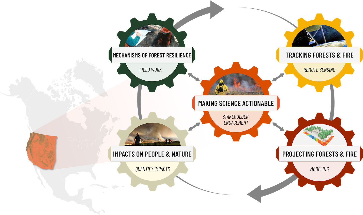
Key Objectives

  • Making science actionable by ensuring the research agenda is responsive to decision-maker needs and that the best available science guides decision making and adaptation.
  • Identify the mechanisms that underpin forest resilience with experiments and field work. Understand and predict where, when, and why the risk of non-reversible forest loss is greatest.
  • Track the changing nature of forest conditions and fire regimes in the western US using legacy and state-of-the-art remote sensing platforms. During an era of unprecedented investment in proactive forest management, this will allow us to precisely measure progress.
  • Projecting forests and fire by feeding remote sensing data into forest models to determine how current and future stewardship actions may shape future outcomes.
  • Quantify impacts on people and nature. This includes biodiversity, air quality, carbon storage, and water. Our model will help us better project how and where ecosystem benefits will change, and how they might be impacted by different management strategies.


WFFRC key objectives graphic

Some Background Relevant to Discussion of the Recent New York Times Story on Wildfires

Steve posted about the NY Times story and when I first read it, I thought it would be a terrific piece to analyze from the sociology and philosophy of science perspective.

For me, with a background in what used to be called “forest biology” i.e., physiology and genetics of forest trees, it is an example of what some call disciplinary encroachment.

Now I want to be perfectly clear about one thing… this table from Google AI makes it sound intentional.  Having observed my field for over 50 years, it’s much more systemic and incremental than that.  I once went hunting for forest economists to answer a practical question and the ones with expertise were mostly retired, replaced with more abstract kinds of researchers (except for Extension, so thank you land grants!)

**************

I first noticed it when I was on a review of the Rocky Mountain Station in the 90’s.  While I was supporting a project on fish genetics (it seems important to know how far they move, right?) the Assistant Director explained to me that organismal biology was basically unnecessary,  and that “systems thinking” would obviate the need for it.  This actually goes back to history of science, with mathematics being scientifically cooler than observations and the somewhat tacky world of organisms and dirt and blood. There’s a reason that “physics envy” is an expression.

Some research. and its definitions and categories, has grown increasingly abstract over time.   For example, take mushroom collecting. You could call it “mushroom collecting” and study who does it and where, and maybe what that means for the relevant economies. Or the impacts, say on a forest in Wisconsin. Or you could call it “non-traditional forest products”. That was a popular category for most of my career. Now it is only a part of “ecosystem goods”- a term which also includes, I suppose, wheat from wheat fields.  Then there are “ecosystem goods and services” which I guess can be studied, but it is hard for me to see any application at that level of abstraction.

******************

In other words, the scientists we hire and fund come with different approaches that can lead to different conclusions.  We can examine the spatial and temporal scales they look at, and more specifically the places and times they look at, the tools they use (often the tools set up the scientific worldview, or does the scientific worldview choose the tools), and the definitions they use or categories.  Then there’s how whether and how they use models.  And how they specifically talk about the uncertainty associated with the findings of the study. That’s why I’m a bit skeptical when folks say “the science” says.. I would ask the above questions..

In most of my scientific career, even people in my own discipline did not agree on many things.  And there is no grand funding or famousness to be found in my field, so being right or wrong does not carry the burden of affecting policy.  So let’s analyze the Times story from this frame.


Things Common to All Three Alternatives From Roadless DEIS

This is a handy table from the DEIS:

Things Common to All Alternatives

1. No changes are proposed to state-specific rules for Idaho and Colorado

2. No alternatives would compel the amendment or revision of any land management plan. While the rulemaking would not require such changes, plans may be amended in any manner whatsoever and are revised periodically (16 U.S.C. 1604(f)). Local responsible officials (forest supervisors and regional foresters) would continue to have discretion to amend or revise a land management plan as deemed necessary.

Thank Gaia for that one!

3. Any future administrative changes, amendments, or revisions to land management plans would comply with NFMA and planning regulations (36 CFR 219 or the planning directives at FSM 1920 and FSH 1909.12). 

It sounds as if, for Alternative 1, forests who wanted to go into the Areas Formerly Known as IRAs would have to do a plan amendment because the management as an IRA was incorporated into post-2001 plans and pre -2001 plans would automatically revert? Others probably understand more.

4. No alternatives would compel or authorize site-specific ground disturbing activities.

5.The reasonable exercise of reserved or outstanding rights for access, occupancy, and use of National Forest System lands within inventoried roadless areas would not be affected. The rights include those that exist by law or by treaty. They include, but are not limited to, the right to provide reasonable access across National Forest System lands to private property, mining claims for locatable minerals under the 1872 Mining Law, land uses protected by Native American treaty rights, and uses under the Alaska National Interest Lands Conservation Act.

I know some folks have raised red flags about strategic minerals. Those are (almost all) locatable and subject to the 1872 Mining Act.  So the 2001 is no protection against folks mining them.

6. All alternatives would allow for the continuation, transfer, or renewal of existing land-use authorizations for activities in roadless areas. “Authorizations” refer to land uses allowed under a special use permit, contract, or similar legal instrument. Numerous types of lands and recreation-related authorizations are issued for occupancy and use of National Forest System lands.

7.  Other Forest Activities that are not otherwise prohibited are permissible in inventoried roadless areas under all alternatives, if not restricted by land management plans or other law, regulations,and policies.These activities include, but are not limited to, the following:
• Maintaining existing roads;
• Constructing or maintaining motorized and non-motorized trails;
• Engaging in hunting, fishing, hiking, camping, and other recreational uses;
• Using a motorized vehicle, such as an off-highway vehicle, on a trail open to motorized use;
• Riding a bike on a trail open to mechanized use;
• Implementing prescribed burning; and
• Grazing livestock.

I’m not sure that this list is complete, I would think firewood cutting and other non-commercial (but permitted) tree cutting activities are also OK? What the 2001 says is .. “The cutting, sale, or removal of timber is needed and appropriate for personal or administrative use, as provided for in 36 CFR part 223; ”

36 CFR part 294.13 (b)(3)

Maybe there are others?

Alternative 3 in Roadless DEIS: A Middle Path?

Here’s a link to the DEIS Basically, it  fixes maps, and takes out WUI.

Removing about ½ million acres of non-National Forest System lands from the national inventoried roadless area maps9. The Roadless Rule applies only to National Forest System lands (see also Potentially Affected Environment).

Curious about that? the footnote says:

There are 44.7 million acres of IRAs managed under 2001 Roadless Rule. Review of the geospatial data found that 44.3 million acres of these are on National Forest System lands, meaning about 0.4 million acres of lands have had land ownership change since the 2001 Roadless Rule or there may be vertical integration problems (mapping errors) between the inventoried roadless data and official land ownership boundary data.

*****

• Removing about 4 million acres of Congressionally designated areas, which have more restrictive and more permanent mandates than the Roadless Rule (see also Potentially Affected Environment).

Conceivably both of the above shouldn’t have been in there anyway.

• Removing 17.9 million acres which include 5.1 million acres within the wildland-urban interface and 6.3 million acres of roaded roadless and 4.7 million acres that are both within the wildland-urban interface and within 0.5 miles of existing roads. The remaining acreage was removed as the small, isolated areas did not meet previous mapping criteria.

“Roaded roadless” was just an artifact of the mapping process used in 2001; that’s why there are clauses about “substantially altered” acres being included.

♦ Roaded inventoried roadless areas were defined as the area within 0.5 miles (either side) of existing roads.
♦ WUI based on the Healthy Forests Restoration Act’s (HFRA) definition, which includes the areas identified in an existing Community Wildfire Protection Plans or, where a Plan is not in effect, the extent of at-risk communities and up to a 1.5-mi buffer around the communities and areas around evacuation routes for at-risk communities. The mapping process resulted in some small fragments of former IRAs remaining. Under this alternative, USDA would apply past criteria for designating IRAs and the western US (west of the 100th meridian) and Alaska, only retaining areas that are greater than 5,000 acres or share a border with Wilderness or recommended Wilderness. East of the 100th meridian inventoried roadless areas of any size were retained.

We had many lengthy discussions about WUI definitions and size of buffers (not sure we talked about evacuation routes specifically) during the Colorado process. You have to pick something and the choices were some kind of mapping, or using HFRA definitions. Certainly there are advantages to HFRA definitions.  It might encourage communities to update theirs, although I’m not sure CWPPs are all equally worthy. But the fact is it’s enshrined in legislation, so there’s that.

Footnote 11, for those of you less familiar…

WILDLAND-URBAN INTERFACE.—”The term ‘‘wildland urban interface’’ means—(A) an area within or adjacent to an at-risk community that is identified in recommendations to the Secretary in a community wildfire protection plan; or (B) in the case of any area for which a community wildfire protection plan is not in effect—(i) anarea extending 1⁄2-mile from the boundary of an at-risk community; (ii) an area within 11⁄2 miles of the boundary of an at-risk community, including any land that—(I) has a sustained steep slope that creates the potential for wildfire behavior endangering the at-risk community; (II) has a geographic feature that aids in creating an effective fire break, such as a road or ridge top; or (III) is in condition class 3, as documented by the Secretary in the project-specific environmental analysis; and (iii) an area that is adjacent to an evacuation route for an at-risk community that the Secretary determines, in cooperation with the at-risk community, requires hazardous fuel reduction to provide safer evacuation from the at-risk community”. (Healthy Forests Restoration Action of 2003; 16 U.S.C. 6511 (16)

I heard different things about processes for boundary modifications in the 2001 Rule, one is that you could do it (i.e., there is a formal process) but no one does, and the other you can’t do it. Maybe someone here knows more.  It seems important.

Here’s what Alternative 3 does:

This alternative also includes provisions to make modifications and administrative corrections to inventoried roadless area boundaries, responding to comments about issues with inaccurate national mapping. The following procedures are included in this alternative allow site-specific boundary modifications or corrections:
a. Modifications to boundaries. Responsible officials, working with local government, Tribes, and interested parties, may propose boundary modification to the Chief. Modifications and additions approved by the Chief will be reflected in the set of maps maintained at the national headquarters office of the Forest Service. Modifications of inventoried roadless area boundaries may be made to correspond with geographic features, land management plan management areas, or for other reasons. A boundary modification is not required to perform work done under an exception pursuant to §§ 294.12(b) or 294.13(b). Public notice with a minimum 30-day comment period will be provided for any proposed boundary modifications.
b. Administrative corrections to boundaries. The Chief of the Forest Service may issue administrative corrections. Administrative corrections to the maps of any inventoried roadless area are adjustments to correct clerical errors, to conform with new statutory or regulatory requirements, or to correspond with changes based on improvements in mapping technology.

*************

There are some issues that we had in Colorado that alternative 3 doesn’t touch.. bringing in equipment to fix dams, roads to help manage vegetation along powerlines, and other relatively small issues that could be helped by restricting access on the roads.   But I think this alternative, for the most part, has the greatest potential.


Thinking About the Spatial Scale Where Roadlessness is Decided: Idaho and the Phosphate Mine

We’re probably going to see this a lot in dealing with Roadless; because they wanted to do a national rule, they couldn’t make specific exceptions, even when they seem totally rational to some of us.  If they picked the most obvious cases, where to draw the line?  So nationalizing forced some decisions that didn’t make sense if we look at a different scale.  This is part of looking at what Idaho and Colorado found as a “need for change” with the 2001.

I went back to the 2001 final rule which specifically addressed phosphate mining on the Caribou-Targhee:

The FEIS identified potential impacts on future phosphate mining on the Caribou National Forest, the only area of active phosphate mining on NFS lands. The FEIS acknowledged that phosphate production from the Caribou accounts for about 12% of national production, and is used to supply regional producers of phosphate fertilizer products and elemental phosphorous. The analysis included an estimate of phosphate resources within inventoried roadless areas of 873.3 million tons, and a description that about 8,000 acres of the area of Known Phosphate Lease Areas are within inventoried roadless areas.

Here’s the Department’s decision rationale:

The Department has decided not to adopt the exception for future discretionary mineral leasing because of the potentially significant environmental impacts that road construction could cause to inventoried roadless areas, but instead determined a more limited exception is appropriate. Existing mineral leases are not subject to the prohibitions, nor is the continuation, extension, or renewal of an existing mineral lease on lands under lease by the Secretary of the Interior as of the date of publication of this rule in the Federal Register . Additionally, road construction or reconstruction may be authorized for new leases on these same lands in the event that application for a new lease is made prior to termination or expiration of the existing lease.

The Department recognizes that this decision may have major adverse economic impacts on a few communities dependent on mineral leasing from inventoried roadless areas. However, if road construction and reconstruction were allowed for future mineral leasing on lands not under mineral lease as of the date of publication of this rule in the Federal Register , an estimated 59 miles of new roads would be constructed in inventoried roadless areas over the next five years. Road construction or reconstruction in support of future mineral leasing on lands not presently under mineral lease could continue at this level or in greater amounts into the foreseeable future. Over an estimated 10 million acres of inventoried roadless areas could be roaded for exploration and development of leasable minerals, although the agency believes it is unlikely that more than a small percentage of these acres would contain minerals sufficient for economic development.

It looks like some folks asked for specific exemptions, but the Department had to make a decision for everywhere all at once.  Going back through time, I also wonder if technology has changed a bit.. maybe (some) exploration could be done without roads.  Even in 2001, they believed that only a small percentage would be worth developing. Today we know a great deal more about a) what minerals are important for national security and b) where they might be.

As it happens, the Idaho Rule specifically allowed road construction and surface disturbance for phosphate mining on roughly 5700-6000 (according to Google AI) acres within the Caribou-Targhee. For context, the Idaho Rule covers 9.3 million acres.  Those roads may well be administrative and closed to the public.

It’s another kind of “pick a lane” question.. from the same people I’ve heard both “roads are bad because people light fires and disturb animals” AND “if there’s a road on federal lands we should all be able to drive on it.”

I asked AI about whether these Simplot roads are open to the public.

No, J.R. Simplot Company industrial haul and access roads located within Inventoried Roadless Areas (such as on the Caribou-Targhee National Forest in Idaho) are not open to the general public. These operational and corporate haul roads are authorized strictly under special-use permits for industrial mining, heavy equipment, and company maintenance. [1, 2, 3]

Of course, folks are concerned about environmental impacts of mining, but that is covered in the EIS or EA for whatever activity.