BNIK Monument: Protected Only From Future Mining Claims? A Look at What Will Continue on the Monument

Note: this post has been updated to reflect corrections on the mineral leasing vs. locatable question supplied by a member of the TSW community.

Having read through the Proclamation, my impressions were that 1) there’s a lot of human roads, powerlines, and other human development within the Monument, 2) not much is going to change except for some things about new minerals*, and 3) there’s a lot more planning and advisory groups and and public involvement. Which will keep agency folks likely tied up from doing the fuels and prescribed burning funded by Congress and managing recreation pressure. With reduced numbers of people and difficulty hiring- on the other hand, I didn’t see a required plan timeline (maybe I missed it). And it often takes two years to get all the FACA paperwork done, which would potentially take us past the beginning of the next Admin. It might have been simpler to say “hey FS and BLM, you’re doing a swell job at protecting things, we’re just going to order no new mineral leasing..”. But perhaps there’s no legal way to do that kind of surgical intervention focused on what appears to be the real target.

*update-“Uranium is not a leasable mineral under the Mineral Leasing Act. It is locatable under the Mining Law of 1872. So DOI is closing off the land to entry under the Mining Law to stop uranium development. Those holding mining claims will likely be required to go through a validity determination to determine if they have a commercially viable mine under the tests established by that process. It’s possible that the withdrawal from all forms of entry under public land law could prohibit wind and solar facilities that are permitted under FLPMA title V ROW. They are only allowed to use public land for wind and solar if they obtain a ROW permit under FLPMA the public land law statute. All the existing infrastructure is a FLPMA Valid Existing Right and protected by Fifth Amendment, FLPMA and terms of proclamation.”

“History: 1. Clinton designated a number of BLM monuments at the end and when Bush administration arrived they were left with the planning that does go through NEPA.
2. Obama’s 20 year withdrawal of this same area was challenged by NMA (National Mining Association) unsuccessfully in AZ and Ninth Circuit. NMA v. Zinke [Salazar] (2017) arguing the Secretary lacked withdrawal authority among other reasons. The litigation started in 2011 over the NEPA prepared for the withdrawal by Salazar.”

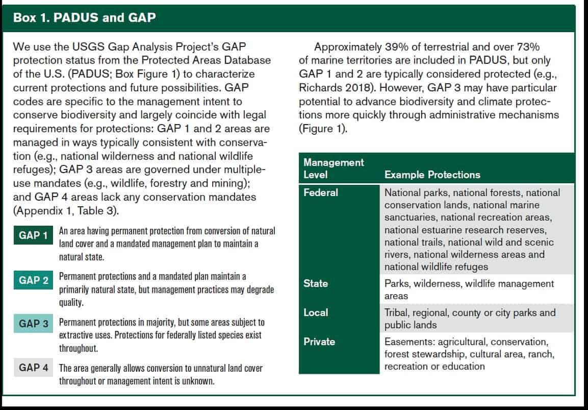
And going back to the previous post, remember that to the GAP 1 and 2 types, the whole Monument is now more Protected (roads and all) than a Forest Service Roadless Area, or even than it was two weeks ago.

****************************

Interesting story by Bobby Magill in Bloomberg Law..

The monument will help the US atone for forcibly removing tribes from parts of the Grand Canyon when Congress declared it a national park more than a century ago, a senior White House official said, speaking to reporters Monday on condition of anonymity.

Hmm.. helping “atone”.  Why not just give the Park back to the Tribes directly?

Anyway..

The monument will help address past injustices and protect lands that many tribes refer to as their ancestral home, the official said. The land around the Grand Canyon shouldn’t be open to new mining claims, the official said. Mining companies are interested in the area to help boost a domestic uranium industry they see as key to bolstering emissions-free nuclear energy. Environmental and tribal groups worry uranium mining will contaminate water flowing through tribal land and harm the Grand Canyon.

But the monument isn’t expected to block Energy Fuels Inc. from mining for uranium at its existing Pinyon Plain Mine, which will be within the monument about 13 miles south of the Grand Canyon.
Some Mining Continues
The company’s rights to uranium and high-grade copper deposits at Pinyon Plain have been affirmed by federal courts, Energy Fuels Vice President Curtis Moore said. Even with the monument designation, the company is preparing for production to begin sometime within the next two years, he said. The company has other uranium prospects in the area, and if the monument threatens any valid existing rights to those minerals, “we’d probably have to pursue a takings challenge,” Moore said.

“It just doesn’t seem like great policy to be locking up our best uranium deposits,” Moore said, calling them “carbon killers” because they provide fuel for nuclear power plants. All valid existing rights to minerals within the monument, including uranium, will be preserved, White House officials said. The monument affects only future mining claims.

Back to the Declaration:

 All Federal lands and interests in lands within the boundaries of the monument are hereby appropriated and withdrawn from all forms of entry, location, selection, sale, or other disposition under the public land laws or laws applicable to the Forest Service, other than by exchange that furthers the protective purposes of the monument; from location, entry, and patent under the mining laws; and from disposition under all laws relating to mineral and geothermal leasing.

**************

Public Involvement, some Service-Firstiness and Joint Planning

The Secretaries shall provide for maximum public involvement in the development of the management plan, as well as consultation with federally recognized Tribal Nations and conferral with State and local governments.  In preparing the management plan, the Secretaries shal1 take into account, to the maximum extent practicable, maintaining the undeveloped character of the lands within the monument; minimizing impacts from surface-disturbing activities; providing appropriate access for livestock grazing, recreation, hunting, fishing, dispersed camping, wildlife management, and scientific research; and emphasizing the retention of natural quiet, dark night skies and scenic attributes of the landscape.  In the development and implementation of the management plan, the Secretaries shall maximize opportunities, pursuant to applicable legal authorities, for shared resources, operational efficiency, and cooperation, and shall, to the maximum extent practicable, carefully incorporate the Indigenous Knowledge or special expertise offered by Tribal Nations and work with Tribal Nations to appropriately protect that knowledge.

I wonder if they need alternatives and an EIS ? “The Important People made all the Important Decisions without involving you, but you folks directly impacted are allowed to color within the lines we’ve drawn” -kind of demoralizing, I would think.

Tribal Nation Co-Stewardship

Lots of Secretaries’ “exploring” this and that language. again it sounds like standard policy under the 2021 Joint Secretarial Order number 3403. But maybe there are differences, perhaps knowledgeable people can point them out?

 The Secretaries shall explore opportunities for Tribal Nations to participate in co-stewardship of the monument; explore entering into cooperative agreements or, pursuant to the Indian Self-Determination and Education Assistance Act, 25 U.S.C. 5301 et seq., contracts with Tribes or Tribal organizations to perform administrative or management functions within the monument; and explore providing technical and financial assistance to improve the capacity of Tribal Nations to develop, enter into, and carry out activities under such cooperative agreements or contracts.  The Secretaries shall further explore opportunities for funding agreements with Tribal Nations relating to the management and protection of traditional cultural properties and other culturally significant programming associated with the monument.

The Secretaries shall consider appropriate mechanisms to provide for temporary closures to the general public of specific portions of the monument to protect the privacy of cultural, religious, and gathering activities of members of Tribal Nations.

There’s a Tribal Commission to give input on the plan and management of the Monument.  There’s also a FACA Committee with a RAC-like list of the usual suspects.

 The advisory committee shall consist of a fair and balanced representation of interested stakeholders, including the Arizona Game and Fish Department; other State agencies and local governments; Tribal Nations; recreational users; conservation organizations; wildlife, hunting, and fishing organizations; the scientific community; the ranching community; business owners; and the general public in the region.

The Monument Already Has Lots of Human Structures  and Those Things Can Be Expanded and  New Ones Built

Nothing in this proclamation shall be construed to preclude the renewal or assignment of, or interfere with the operation, maintenance, replacement, modification, upgrade, or access to, existing or previously approved flood control, utility, pipeline, and telecommunications sites or facilities; roads or highway corridors; seismic monitoring facilities; wildlife management structures; or water infrastructure, including wildlife water developments or water district facilities, within the boundaries of existing or previously approved authorizations within the monument. Existing or previously approved flood control, utility, pipeline, telecommunications, and seismic monitoring facilities; roads or highway corridors; wildlife management structures; and water infrastructure, including wildlife water developments or water district facilities, may be expanded, and new facilities of such kind may be constructed, to the extent consistent with the proper care and management of the objects identified above and subject to the Secretaries’ authorities, other applicable law, and the provisions of this proclamation related to roads and trails.

Transportation Planning

For purposes of protecting and restoring the objects identified above, the Secretaries shall prepare a transportation plan that designates the roads and trails on which motorized and non-motorized mechanized vehicle use, including mountain biking, will be allowed.  The transportation plan shall include management decisions, including road closures and travel restrictions consistent with applicable law, necessary to protect the objects identified in this proclamation.  Except for emergency purposes, authorized administrative purposes, wildlife management conducted by the Arizona Game and Fish Department, and the retrieval of legally harvested elk and bison, which are otherwise consistent with applicable law, motorized vehicle use in the monument may be permitted only on roads and trails documented as existing in BLM and Forest Service route inventories that exist as of the date of this proclamation.  Any additional roads or trails designated for motorized vehicle use must be designated only for public safety needs or the protection of the objects identified above.

It’s not clear to me if temp roads for fuel treatments would be OK..”public safety” “protection of species (species being an object identified above)?” But those wouldn’t be system roads so.. and here’s more on veg management:

The Secretaries may carry out vegetative management treatments within the monument to the extent consistent with the proper care and management of the objects identified above, with a focus on addressing ecological restoration; wildlife connectivity; or the risk of wildfire, insect infestation, invasive species, or disease that would endanger the objects identified in this proclamation or imperil public safety.  Nothing in this proclamation shall be construed to alter the authority of any party with respect to the use of prescribed fire within the monument.

Grazing and Fire Suppression

Nothing in this proclamation shall be deemed to prohibit grazing pursuant to existing leases or permits within the monument, or the renewal or assignment of such leases or permits, which the BLM and Forest Service shall continue to manage pursuant to their respective laws, regulations, and policies.

Nothing in this proclamation shall be construed to alter the authority or responsibility of any party with respect to emergency response activities within the monument, including wildland fire response.

Military Uses and Fish and Wildlife

 Nothing in this proclamation shall preclude low-level overflights of military aircraft, flight testing or evaluation, the designation of new units of special use airspace, the use or establishment of military flight training routes, or low-level overflights and landings for wildlife management conducted by the Arizona Game and Fish Department over the lands reserved by this proclamation.  Nothing in this proclamation shall preclude air or ground access to existing or new electronic tracking communications sites associated with special use airspace and military training routes.

Nothing in this proclamation shall be deemed to enlarge or diminish the jurisdiction or authority of the State of Arizona with respect to fish and wildlife management, including hunting and fishing, on the lands reserved by this proclamation, or to affect the State’s access to the monument for wildlife management, including access prior to and during the development of the management and transportation plans provided for above.  The Secretaries shall seek to develop and implement science-based habitat and ecological restoration projects within the monument and shall seek to collaborate with the State of Arizona on wildlife management within the monument, including through the development of new, or the continuation of existing, memoranda of understanding with the Arizona Game and Fish Department.


Does Monumentizing Really “Protect”? And Various Admin and Other Groups’ Thoughts on 30 x 30


This is the CEQ USDA DOI and Commerce joint write-up on how to achieve 30 x 30


I am going to go out on a limb here..I think the way some groups in tight with the Admin, or possibly the Admin itself (can’t easily tell), have chosen to classify federal lands for “counting” in 30 x 30 is messed up and potentially meaningless. To get started,  I think it’s important to define terms.   I’m going to capitalize Protection when I mean “protected areas as defined by various entities, that is, GAP 1 and 2, for the 30×30 effort.” In the next post, we’ll look at what’s in and what’s out based on the recent Baaj Nwaavjo I’tah Kukveni — Ancestral Footprints of the Grand Canyon National Monument (BNIK NM) declaration.  It seems to me mostly like BAU for the BLM and FS, but requiring another planning process :(.  I’m not sure that most of the reporters read the declaration itself and not just the press release.

The Center for American Progress (CAP) is a very powerful political entity and here are their policy recommendations.. it sounds like a laundry list of what the Biden Admin has been doing recently.

In a November 2022 report from its series on executive action to address the nature crisis, CAP took a deeper look at some of the most powerful conservation tools available to President Biden. In particular, the report identifies the top eight most impactful opportunities for near-term executive action. These include opportunities to designate new protected areas; expand national wildlife refuges; exclude sensitive and sacred places from drilling and mining; and establish national rules to guide conservation of U.S. Bureau of Management lands and the country’s oldest federally owned forests. In another publication from the same series, CAP highlights specific community and Tribally-led proposals for national monuments and marine sanctuaries already primed for executive action, from the proposed Avi Kwa Ame National Monument in Nevada to the Chumash Heritage National Marine Sanctuary in California. Enacting these recommendations will deliver real conservation benefits and should be prioritized.

They also indicated that to them, talking about “what counts” is beside the point.

However, heated arguments about “what counts” can miss the much bigger point behind this national “30×30” conservation goal. The ambitious 30×30 target can, and really must, be an inclusive call to action—a promise to jointly address the climate and biodiversity crises by accelerating the pace at which the country is protecting nature.

As a scientist,  I see two problems with CAP’s formulation. First, if you are indeed thinking about climate and biodiversity, then to make progress you would absolutely need to define what you want specifically, and various risks, and identify tradeoffs.  Second is that, of course, just Protecting something does not actually address both climate and biodiversity.  Not a burned tree nor a cheatgrass seed cares much about lines on maps (back to the BLM sage grouse habitat paper).

A simple example is this Oregon Public Broadcasting story about the Bootleg Fire and carbon credits (which is a good article to read anyway).  If you take out the cap’n’trade carbon credits part of the story, you have “adios, carbon we thought we had” from the area.  You can say that somehow this wouldn’t have happened if it had been in a Protected area, or somehow wouldn’t have had negative effects on biodiversity and carbon simply by drawing a line! How cool is that? But not actually real in terms of biology.

So the question that CAP raised is actually pretty important.. what’s in and out for 30 x 30? Defenders of Wildlife, for example, and the State of California, think it should only include Gap 1 and 2 acres.

*************

I couldn’t find a place where the Biden Admin says what counts to them  toward 30 x 30.  I did find that CEQ, Interior, USDA and Commerce wrote an interesting paper on how to achieve 30 x30 that leads with “Pursue a collaborative and inclusive approach to conservation” (see table of contents above).  There were also statements by the Admin about how working lands should count.

The interesting thing about using Gap 1 and 2, as per Defenders and others, is that, say Forest Service Roadless Areas are not included, as they are not “permanent,”  but places like the San Gabriel National Monument are included as Protected.  Having worked for years on Roadless, they seem pretty permanent to me.  I’m sure if you tried to measure “intactness” they would beat the SG National Monument or even parts of Yellowstone (Gap 1) by a mile.   It seems like a serious general flaw that these definitions consider recreation-even industrial scale- as no barrier to Protection. And in GAP1 all you need is a “management plan” to maintain a natural state.. not actually a.. “natural state” whatever that is.

Which as far as I’m concerned from any biological point of view, is pretty meaningless.  So let’s move on to the new National Monument.

Here’s a link to the Monument Proclamation- now remember that all these acres were managed by BLM and the Forest Service under their multiple- use mandate.  But GAP- wise, just the President’s signature on a piece of paper transforms them into Protected.

There’s lots of verbiage about how declaring the area a Monument will “address the legacy of dispossession and exclusion” but the actual actions in the Monument sound like BLM and FS current policy.

Conserving lands that stretch beyond Grand Canyon National Park through an abiding partnership between the United States and the region’s Tribal Nations will ensure that current and future generations can learn from and experience the compelling and abundant historic and scientific objects found there, and will also serve as an important next step in understanding and addressing past injustices.

Then they make the case for historic and scientific significance that they need to make for the Antiquities Act and to argue that 1.1 mill acres is the least amount of acres necessary  I do see this as heading to the Supreme Court if some people with lawyers care enough.

If you read through the paragraphs, it sounds like the BLM and the FS have been doing a swell job. You could also get the impression that almost any area could equally qualify with historic habitation by Native people, early Euro-American history, biodiversity and scientific interest. Here’s an example:

Protecting the areas to the northeast, northwest, and south of the Grand Canyon will preserve an important spiritual, cultural, prehistoric, and historic legacy; maintain a diverse array of natural and scientific resources; and help ensure that the prehistoric, historic, and scientific value of the areas endures for the benefit of all Americans.  As described above, the areas contain numerous objects of historic and scientific interest, and they provide exceptional outdoor recreational opportunities, including hiking, hunting, fishing, biking, horseback riding, backpacking, scenic driving, and wildlife-viewing, all of which are important to the travel- and tourism-based economy of the region.

Yup, sounds like the point is to keep protecting what the BLM and FS already protected..

Next post:  let’s see what is going to continue, and what will change, at BNIK NM.


Forest Service Wins- Fremont-Winema National Forest with CE 6

This is usually Jon’s round-up territory but I thought it was so interesting it deserved a post of its own, plus it’s my old stomping grounds. Thanks to a friend of The Smokey Wire, it came via a Law 360 article.

Law360 (August 7, 2023, 8:27 PM EDT) — An Oregon federal judge has thrown out environmentalists’ lawsuit attempting to block commercial lumbering in a national forest, ruling regulators properly determined the timber thinning projects were exempt from stringent environmental review.
The U.S. Forest Service correctly approved logging almost 30,000 acres in the Fremont-Winema National Forest over three projects aimed at improving wildlife habitat and timber stands, U.S. District Judge Michael J. McShane said in a Friday order granting the service’s motion for summary judgment. In the same ruling, Judge McShane turned down a summary judgment counter from the groups, Oregon Wild and Wildearth Guardians, ruling they hadn’t shown the USFS granted unlawful exclusions from environmental review for logging and waited too long to challenge the exclusion category itself.
The environmental groups sued last year, alleging the forest service used categorical exclusion six to create a loophole that let logging companies bypass impact analysis of the South Warner, Bear Wallow and Baby Bear projects in the national forest. The exclusion may also be invalid since it has now been used to approve big, commercial logging projects without considering their environmental consequences, the groups alleged.
But Judge McShane, in his Friday ruling, said the exclusion’s language permits commercial logging and has no limit on the size of timbering projects. Instead, it bars herbicide use and restricts road building, the judge added. The forest service explained how thinning the forest would improve habitat for birds, turtles and deer, cut back overcrowded conifer trees and reduce the risk of insect infestation, Judge McShane said.
The USFS, therefore “reasonably determined that thinning to improve wildlife habitat and favorable timber stand conditions” fell within the scope of the exclusion, the judge ruled.
Turning to the groups’ challenge to the exclusion itself, Judge McShane said opponents had missed the six-year deadline to get the 1992 rule overthrown. Conservation groups were not entitled to an exception from that deadline, the judge added.
Oregon Wild and WildEarth Guardians argued that the forest service never determined commercial logging had no significant impacts when it approved the thinning exclusion, a violation of the National Environmental Policy Act.
But in order to receive an exemption for the case under the Ninth Circuit’s decision 1991 decision in Wind River Mining Corp. v. United States , opponents had to make a substantive challenge that the forest service lacked legal authority to make the exclusions, Judge McShane said.
“The problem in plaintiff’s argument is that NEPA is a procedural statute,” the judge said. “NEPA directs agencies to create categorical exclusions and requires certain procedures for doing so. It does not dictate specific substantive results.”
The USFS declined to comment Monday. A representative for the environmental groups did nots represented by Natalie K. Wight and Sean E. Martin of the U.S. Attorney’s Office for the District of Oregon. The environmental groups are represented by Oliver J.H. Stiefel, Erin E. Hogan-Freemole and Meriel L. Darzen of Crag Law Center.

So that’s the legal side. I’m finding out more about the projects themselves. Interestingly the South Warner Project seems to be linked to MOG at least in the minds of some.

The South Warner Project includes commercial logging of large, old trees under the guise of “timber stand and wildlife habitat improvement,” said John Persell, Staff Attorney at Oregon Wild.  “It is yet another example of why a national rule protecting mature and old-growth forest stands is needed to address the climate and biodiversity crises.”

As a former NEPA practitioner, I wouldn’t have rolled the dice on Category 6, but if you’re going to roll the dice, you should go big, like 30K acres.

Baaj Nwaavjo I’tah Kukveni Grand Canyon National Monument:1.1 Mill Acres of Not-Mining?

Exact size and boundaries of monument are not yet known.
Source: Bureau of Land Management

As for me, to know that with a flick of a pen the President can undo the painful and laborious work of RMPs and Forest Plans, it would not encourage me to spend volunteer hours working on them.  For employees, it reminds me of my old expression about planning.. “the pay’s the same” and “if you’re not the lead mule, the scenery never changes.” But maybe that’s just me.

The WaPo has an interesting story on the  Baaj Nwaavjo I’tah Kukveni Grand Canyon National Monument (proposed with so far unknown boundaries).

Federal officials have started telling tribal and environmental groups to be available for a potential Grand Canyon announcement early next week, which would fall during Biden’s travel, said four of the people, all of whom spoke on the condition of anonymity to discuss an announcement not yet public.

Who needs those pesky old maps.. or talking to people in the area in some kind of public process?

“No decisions have been made,” White House spokesman Abdullah Hasan said in an email. “But I can tell you that President Biden has conserved more land and water in his first year than any president since JFK, and his climate protection record is unmatched.”
Apparently there are Important People and Groups who think that Biden hasn’t done enough things they want, so we can expect a flurry of “things those groups want” prior to the election.  Again, as  a volunteer, commenting on the FS MOG ANPR, the BLM public lands rule,  reducing royalties for solar and wind, the CEQ NEPA regs, more regs for oil and gas.. it’s a lot.
The way that the WaPo describes it, it’s all about uranium and Tribes that don’t want it.

Advocates have been lobbying for a monument designation in part to honor long-standing Native American connections to the Grand Canyon. For the Havasupai Tribe, Baaj Nwaavjo means “where tribes roam,” and for the Hopi Tribe, I’tah Kukveni means “our ancestral footprints.” Other tribes, including the Hualapai, which means “people of the tall pines,” also have advocated the designation.

“This monument will show that we are beginning to protect the lands of the world,” Dianna Sue WhiteDove Uqualla, a Havasupai Tribal Council member, said in a July statement anticipating the decision and provided by a coalition of monument advocates.

This is one of those areas in which it looks like low-carbon energy sources runs into the 30×30 idea, as well as Tribal spiritual values.  But we might be able to figure out who’s really holding the cards by comparing the Biden Admin position across different projects.  Anyway, here’s the industry position:

Industry officials said they will explore ways to fight the decision. They said it would lock up some of the country’s highest-grade uranium deposits at a time when such fuel would be useful to the country’s clean energy and geopolitical goals. Russia provides more than 20 percent of U.S. nuclear fuel, and Congress is actively exploring new laws to boost U.S. uranium production and enrichment in response to Moscow’s war on Ukraine.

In an email, Curtis Moore, senior vice president of marketing and corporate development for Energy Fuels — one of the few uranium miners with operations in the United States — blasted the decision as making “zero sense.”

He said it contradicts several of the administration’s stated policies, including “supporting clean energy production and punishing Russia’s aggression in Ukraine.”

Monument advocates have said only 1.3 percent of U.S. uranium reserves are in the Grand Canyon region.

That’s not my question.. mine would be “why do you need 1.1 mill acres to say “no uranium mining here”?”  Maybe that will come out in the announcement.

The announcement would help kick off an effort to promote Biden’s climate agenda, including progress from last year’s major climate-spending law, the Inflation Reduction Act. Biden is planning a three-state tour, with other stops in New Mexico and Utah, to talk about billions of dollars of investment that the law has prompted manufacturing companies to commit to making equipment that produces cleaner energy.

Arizona has become a major focus for Biden and other Democrats as they have gained ground politically in the state. The state has been one of the biggest beneficiaries of their big spending bills, with more than $8 billion in planned investment in a giant battery factory and other manufacturing developments, especially near Phoenix, according to the advocacy group Climate Power, which tracks such announcements.

In case you’re curious, here’s what the Biden Admin Energy Department had to say about the IRA and nuclear

Momentum is building for U.S. nuclear energy and the investments and tax incentives included in IRA guarantee a commitment to nuclear energy that will continue well throughout the nation’s journey to net-zero.

Wouldn’t a serious climate policy identify areas where renewables and mining are to occur? Otherwise it seems a bit like a leaf fluttering on random political winds.

For example, Tribes and environmental advocates tried to block the Thacker Pass lithium mine, also land considered to be sacred.  The Biden Admin was on the side of the mine. I guess we’re left to think that some Tribes are more important than others, some ENGOs are more important than others, or some States are more important than others based on some kind of political calculus.

Monumentizing Doesn’t Magically Produce More Funding: San Gabriel Version

There’s an interesting LA Times article on the San Gabriel National Monument.  It’s easy for a Prez to designate something.. it’s easy to to claim that it’s now under “permanent protection”.. not so easy to have enough money to manage visitors..

Nine years after President Obama upgraded the region to monument status — an act intended to foster a cleaner and safer wilderness — park officials and volunteers have been struggling to cope with the consequences of surging visitation, particularly in summertime.

**********

But how exactly would making a Monument itself make something cleaner and safer?  And it’s not a Wilderness (granted I don’t exactly know what the reporter meant by wilderness). Maybe the Angeles needed more funding, not a Monument designation. I wonder how often this kind of “magically more money” thinking is involved in Monumentizing.

Refuse has been a health concern in the area since 2000, when the California Regional Water Quality Control Board ordered the Forest Service to reduce trash levels in the East Fork to zero within three years.

In response, rangers and volunteers were stationed at popular picnic sites to direct visitors to roadside trash bins and provide them with information about environmental issues and litter laws. They also posted “No Littering” signs printed in English and Spanish.

That strategy was abandoned a few years later because of budget cuts.

Now, there is renewed talk of devising strategies to limit visitors and instruct them on how to be better stewards of the environment.

*****************

The flood of ill-behaved tourists isn’t the only reason for the area’s problems. Implementation of a management plan for the East Fork, finalized in 2019, was stalled by COVID-19 and a lawsuit.

“We desperately need an East Fork stewardship plan that is adequately funded and staffed,” said Isaac Brown, a senior scientist at Stillwater Sciences, a consulting firm specializing in restoring rivers and floodplains.

The Forest Service has long complained of high turnover rates in management, chronic budget cuts, and being unable to pay wages high enough to attract sufficient numbers of “forestry technicians” to remove all the trash that accumulates each day along the East Fork. Pay for such positions in Angeles National Forest start at about $43,600 a year, officials said.

Most of the Forest Service’s budget is set aside for wildfire protection, as well as repairing campgrounds, roads and infrastructure damaged by torrential rains earlier this year, officials said.

Some critics see a connection between chronic overcrowding and the promotional efforts of large nonprofits that seek to increase access to the monument. Critics say the organizations have failed to take into account the toll on wildlife and habitat.

A discarded BBQ grill rests atop a heap of trash beside a river.
Piles of trash have not only blighted the landscape in San Gabriel Mountains National Monument, they have also raised contamination concerns for one of the region’s largest watersheds.
(Allen J. Schaben / Los Angeles Times)

Belen Bernal, executive director of Nature for All, a coalition of environmental and community groups that has long campaigned for more parks and safe outdoor opportunities in one of the largest metropolitan areas in the United States, agrees — up to a point.

“It’s true that we are looking at increased access,” Bernal said. “But during the summer months it’s a whole different ball game. This is a management issue.

“We’re not entirely happy about the situation in the monument. Just a year away from its 10th anniversary, it still doesn’t have enough restrooms, dumpsters or even a visitor center.”


San Carlos Apaches and Forest Service Sign Contract for Restoration

San Carlos Tribe Chairman Terry Rambler (right) signs an agreement with Kurt Davis, deputy forest Supervisor for the Coronado National Forest, to allow the tribe to contract with the federal government to to allow the tribe to take part in large-scale restoration efforts on the Apache-Sitgreaves, Tonto and Coronado national forests and other ancestral lands in order to return them to a natural and historic state.

San Carlos Apache Tribe finalizes restoration agreement with Forest Service

“The U.S. Forest Service and the San Carlos Apache Tribe have forged an agreement to allow the tribe to take part in large-scale restoration efforts.

It was made official earlier this week at a signing ceremony on the reservation.

The tribe now has the legal authority to contract with the federal government to work on the Apache-Sitgreaves, Coronado and Tonto national forests and adjacent ancestral lands while tapping $24 million in infrastructure funding.

The treatments will include fuels reduction and use prescribed fire to return the landscape to a historical and natural state in a culturally sensitive way while emphasizing clean water, medicinal plants and traditional food sources like acorns, berries and wildlife. Initial projects have already begun.”

This seems like a great idea and much easier than “conservation leasing”.. just sign a contract, figure out the projects, and get them done..

Hazard Trees: When and Where Are They Controversial and Why? The White River Forest-Wide Hazard Tree EA

Straight Creek, with Interstate 70 in the background, is pictured on Aug. 3, 2022. Luke Vidic/Summit Daily News

I think it would be interesting for a student to look into why it is so controversial some places, and not so much others. I’m sure part of it is size-related, and part living vs. dead and hazard tree criteria. Perhaps commercialness and species? Or just cultural history of the Forest (in this case, no Timber Wars background that I know of) and its relationship with neighbors? Are hazard tree projects a big concern where you live, or not, or somewhere in-between?

Here’s a story from the Summit Daily News about some current hazard tree/fuel reduction activities near Dillon, Colorado.

Apparently the White River has been working from a forest-wide 2009 hazard tree decision (EA, 92 pages) that also involves removing dead and downed trees for fuel reduction purposes. In 2022, they did a Supplemental Information Report, adjusted some things and kept going. Interesting that no specific areas were identified in advance (condition-based management?), and it doesn’t seem like it has been controversial.

Scheduling of individual hazardous tree removal projects will occur based upon a variety of indicators. The first indicator that will be used to identify areas that will be scheduled for treatment is the presence of hazardous trees. Secondly, those areas will then be prioritized according to the intensity or frequency of hazardous tree occurrence. The third indicator will be identifying the frequency of use; areas identified as high-use will qualify as a priority for treatment over areas that are considered low-use. Access to and from private landholdings as well as the protection of historic features and administrative sites will also be considered when project sites are scheduled for treatment.


Hazardous Tree Definition

Hazardous trees are defined in reference to the Forestwide Hazardous Tree Removal and Fuels Reduction Project as:
Any tree that may fail due to a structural defect and, as a result, may cause property damage or personal injury. Tree failure is difficult to predict with certainty due to the complex interaction between a tree and its environment. Every tree would eventually fail; therefore, knowledge of tree species, site characteristics, and local weather conditions and patterns are essential when evaluating tree hazards. A defective tree is hazardous only when its failure could result in damage to something of value. The following tree specific criteria would be used to identify defective trees.
Any one or more of these criteria would qualify a tree as defective:
1. Dead trees of any species
2. Trees with significant defects
a. Canker rots
b. Root rots
c. Trunk injuries (mechanical damage, stem decay, etc.)
d. Crown defects (broken or damaged branches, forked tops, dead tops, etc.)
e. Exposed damaged roots in cut banks of roads/trails
3. Dying trees
a. About 1/3 + dead limbs and branches
b. Foliage transparency 40% + (thin crown, off-color or dwarfed foliage)
c. Borer attacks obvious and abundant – the presence of insect activity, such as bark beetles or mountain pine beetles, may indicate that a tree has been weakened by other agents.

BLM’s Landscape Intactness Index- Another National Mapping Exercise

The second paper cited in the BLM Public Lands Proposed Rule is called “A Multiscale Index of Landscape Intactness for the Western United States.“.

Landscape intactness has been defined as a quantifiable estimate of naturalness measured on a gradient of anthropogenic influence. We developed a multiscale index of landscape intactness for the Bureau of Land Management’s (BLM) landscape approach, which requires multiple scales of information to quantify the cumulative effects of land use. The multiscale index of landscape intactness represents a gradient of anthropogenic influence as represented by development levels at two analysis scales.

So “intactness” is a measure of “naturalness”.

To create the index, we first mapped the surface disturbance footprint of development, for the western U.S., by compiling and combining spatial data for urban development, agriculture, energy and minerals, and transportation for 17 states.

One interesting thing about this is that it’s not just for BLM it’s for all lands, including FS. You can look at it here or download as a Google Earth file (KML).

The multiscale index of landscape intactness is designed to be flexible, transparent, defensible, and applicable across multiple spatial scales, ecological boundaries, and jurisdictions. The standardized index is intended to serve as one of the proposed core metrics to quantify landscape integrity for the BLM Assessment, Inventory, and Monitoring program. The multiscale index is designed to be used in conjunction with additional regional- or local-level information not available at national levels, such as invasive species occurrence, necessary to evaluate ecological integrity.

It wasn’t easy for me to find exactly how it was calculated. It also looks like the data were collected between 1999 and 2014.  Conceivably in the last 10 years some places developed due to mining or renewable or other energy resources that have since been built out or are permitted to do so.

If I were going to generalize about the current fashion for mapping exercises, what they seem to have in common is:

1) Not being clear at the beginning exactly what the purpose is.. for what kinds of decisions, made at what scales, during what time period?

2) Not involving stakeholders in the development of the mapping exercises, including the development of  specific  measures and how to merge them into indices.

3) Not clear as to whether it’s a one-time thing or there is a plan to update for real-time decision making

3) Not ground-truthing before use

4) Ambiguousness about what they are to be used for and when.. need to be “supplemented by local knowledge” but can be used for “broader scale policy issues”.  Inquiring minds would like to know how information can be useful for broad-scale policy issues without being accurate at the ground level.

and

5) Not coordinating with many extremely similar-sounding exercises by other agencies and NGO’s. Even a simple explanation of why this one is needed, given the other ones would be useful.

To get people to trust, it’s all about transparency and accountability.  The steps I outlined above are not difficult.  It’s a bit head-scratchy as to why the USG, in particular, doesn’t seem to think these steps are important.

**************************

Thinking about other efforts, I think about Pew’s and Conservation Science Partners’ mapping of “ecological value” ideas that came from the conservation science community..

We define ‘ecological value’ as the potential for a given location on the landscape (i.e., a pixel in a gridded landscape raster) to contribute to crucial ecological processes such as supporting biodiversity and connectivity and buffering organisms against the impacts of climate change through carbon storage and accessibility of favorable climate  conditions. This concept is related to that of ‘conservation value,’ as used by Dickson et al. (2014), but does not directly incorporate social/political aspects of conservation such as the proportion of an ecosystem type currently protected.

*****************

Maybe it’s a crazy idea, but what if we jointly decided with stakeholders what was important to protect .. “integrity” vs “conservation value” and so on, and then mapped (on all lands) whatever that was,  as a joint project with local folks  ground-truthing. Oh, and decided what were the threats in that location, and how best to protect from those threats.  Hmm. that sounds like an ideal of RMPs or Land Management Plans.  I’m not a fan of the current processes, but I do like the locus of control.

Threats to the BLM Sagebrush Biome: Cheatgrass and Conifers; Cheatgrass and Fire in the Mohave Desert

The proposed BLM Public Lands Rule regulation included two citations to papers.  I decided to take a look at them and see what helpful info I could glean from them. They are both DOI (USGS) products.

********************

The first one is called “A Sagebrush Conservation Design to Proactively Restore America’s Sagebrush Biome,”  with a bunch of authors and prepared in cooperation with WAFWA and the USFWS. I’m assuming it’s a bird-o-centric view. Still, they are talking about ecological integrity.

These ongoing and anticipated losses in areas of high ecological integrity have been driven primarily by the incursions of invasive annual grasses across the three ecoregions (fig. 12). By 2020 (the final year examined), more areas were moderately or highly threatened by invasive annual grasses than in any year prior, including more than one-half of the Southern Great Basin region. A sudden increase relative to 2016 (the penultimate year examined) was particularly pronounced in the Great Plains region, although none of this region had been deemed high risk. The threat of conifer expansion into the no to low category showed an increase compared with that of 2001; however, expansion into this category held steady from 2016 to 2020, especially in the Intermountain West and Southern Great Basin regions. The team also documented infill of conifer stands, showing an increase in the areas classified as high or very high risk, especially in the Intermountain West region. The footprint of human modification remained relatively constant over time within regions, but the footprints varied considerably across regions—for example, more than 90 percent of the Southern Great Basin region remained at no to low risk by 2020 compared with only 60 percent of the Great Plains region remaining at this level.

From the summary:

Given the number of threats, the scale at which they operate, and the dispersed authority and responsibility to regulate and address threats, this effort may take an almost unprecedented degree of cooperation and collaboration, a bold vision, and ambitious goal setting. To date, substantial investments in collaborative efforts to remove conifers expanding into sagebrush plant communities by Oregon’s SageCon partnership, the Sage-Grouse Initiative, and the Utah Watershed Restoration Initiative have matched the rate of loss to conifer expansion within the Great Basin (Reinhardt and others, 2020).
The results in this study indicate that a similar focus could allocate limited conservation resources to where and when they have the highest probability of achieving desired uplift, which the design can inform.

**********************************

From this paper, a person could develop a regulation that would

  1.  Encourage collaborative work with other agencies and local collaboratives to reduce impacts. States and Tribes are important partners, involved in the development of any regulation (not at the comment period).

2. Since  invasives are a big problem, drawing a line around an area and keeping people out is unlikely to move towards ecological integrity. Same with those pesky conifers.

3. Invasives also change wildfire frequency, and  different grazing techniques can be used to reduce fire danger.

It’s hard for me to see that mapping “intactness” which doesn’t take into account the threat of invasives, determining what is “land health” for other activities, or conservation leasing will help with any of these problems. On the other hand, if you want to keep people out and let whatever happen, that’s fine too, but it’s not promoting biodiversity, natural range of variation nor probably carbon.

************************


A Joshua Tree is seen as the York fire burns in the distance in the Mojave National Preserve on July 30, 2023.
(David Swanson/
AFP via Getty Images)

We’ve seen a bit of this with the current fire in the Mojave National Preserve, burning up Joshua Trees.

Interesting story on a fire in the Mojave National Preserve and the Joshua Trees from the LAist.

More than 77,000 acres of desert landscape have burned over the past few days in the York Fire, the largest on record for the Mojave National Preserve, as high temperatures and strong winds drove flames across the border into Nevada on Sunday.

Flames up to 20 feet tall have been spotted as the fire has torn through mixed desert scrub, yucca, pinyon juniper, and invasive plants like red brome, all of which saw a lot of growth during the recent wet winter.

“I was just driving through that area a week or two before the York Fire and thought ‘This place is going to burn.’ There’s just fuel everywhere,” said Debra Hughson, deputy superintendent of the preserve.

Fires like this have long been rare in Mojave desert ecosystems, with some estimates putting the fire return interval at every couple hundred years. Now, they’re becoming a feature of the landscape, increasing in frequency and jeopardizing the recovery of native species, including Joshua trees. Just a few years ago, the nearby Dome Fire burned more than 40,000 acres and destroyed more than 1 million of the famous trees.

“Fires this big are really a game changer in the desert,” said Todd Esque, research ecologist with the U.S. Geological Survey.

The role invasive species are playing

Invasive species including red brome, cheatgrass and Sahara mustard are helping drive the new fire regime. The weeds thrive in the desert environment, filling in the space between Joshua trees, carrying the fire from one tree to the next. And after fire clears things out, the invasive species quickly move back in.

“They burn every 10 years, which happens in some places where there’s Joshua trees now, because of weeds…now it’s just a straw-colored two dimensional landscape of rolling hills,” Esque said.

A pullback on grazing in this area of the Mojave has led to an increase in the growth of native vegetation as well, with grasses like big galleta also carrying fire.

Joshua trees aren’t really all that adapted to withstand fire. They can re-sprout from their roots after burning, but that’s not always the case if the fire’s too intense.

Even if they do pop back up, their growth rate of roughly three centimeters per year is quite slow, meaning the landscapes we’ve long grown fond of are likely not coming back, at least in our lifetimes. They could take more than a century to repopulate — assuming they do at all. That’s because hotter temperatures and longer droughts, punctuated by frequent fires in the era of climate change, make regrowth more difficult.

The fire is also burning through critical habitat for the desert tortoise, which is listed as a threatened species.


onX Access Efforts and Maine vs. Colorado Private Land Liability Laws

It seems like adding access to public lands is something everyone agrees on, unless I suppose, you are neighbors and there are undesirable effects of “bad apples”.  Or if you think more recreation means more negative environmental impacts.   Well, anyway.. turns out that onX (a company that has apps for hikers, off-roaders and hunters) also contributes to efforts to gain more access to public lands.

Here’s their philosophy:

A coalition of outdoor enthusiasts is stronger than divided groups. The various outdoor communities don’t always agree on how public lands should be managed. But the fact is, industrial development and suburban sprawl are larger threats to our ability to access public lands and waters, and every outdoor community is impacted, directly or indirectly. Efforts to preserve recreational access and keeping open land open will be more effective when outdoor enthusiasts work side-by-side, instead of focusing on our differences and fighting individual battles. By standing up for everyone’s right to access the outdoors, we’ll protect our own right to adventure.

I thought this about Maine was interesting.

Private Land, Public Access

This whole system is founded directly on Maine’s Landowner Liability Law, which is explained by the town of York, “If someone uses your land or passes through your premises for outdoor recreation or harvesting, you assume no responsibility and incur no liability for injuries to that person or that person’s property. You are protected whether or not you give permission to use the land.” This law has instilled good faith within landowners, primarily of large swaths such as timber company holdings, to allow recreational access of all kinds so that the general public can enjoy Maine’s treasured lands.

Well, why is land conservation so important right now in Maine if everything that isn’t posted is good to go? According to Maine Inland Fish and Wildlife, roughly 94% of the forested part of state is privately held. That means that most recreation that happens—whatever your vehicle, discipline, sport, or pastime—is likely going to happen on private land. When the state was mostly farmers and population density was low, that made it simple to know the neighbors across the stone wall. Now, increasing real estate sales, with smaller acreages, are resulting in a state increasingly segmented and, as previously mentioned, posted. This illustrates the importance that land trusts preserve public access, and keep the tradition alive.

In Colorado, we have something similar but perhaps not quite good enough as per this Colorado Sun story about 14ers..

Welcome to the woods. Please scan this code and swear you won’t sue.

After several months of closure, the Decalibron Loop trail accessing four 14ers in the Mosquito Range near Alma will reopen Friday to any hiker who scans and signs a liability waiver on their phones.

Landowner John Reiber is installing signs with a QR code on the road leading from Alma to Kite Lake, the starting point of the 7-mile Decalibron Loop trail that connects Mounts Democrat, Cameron, Lincoln and Bross. If hikers scan the code with their phones and e-sign the waiver, they will be able to legally access Reiber’s property along the Decalibron Loop. If they do not, they will be trespassing.

“This is not a true solution,” Reiber said. “This is a temporary Band-Aid to the problem. The true solution is for us to get the state law changed and fix the Colorado Recreational Use Statute. That is the ultimate fix not just for me but a lot of landowners.”

The owner of private property along the Decalibron Loop trail traversing 14ers in the Mosquito Range near Alma is opening his land to hikers who scan QR codes and sign a liability waiver. (Courtesy photo)

Reiber, who owns a patchwork of mining properties that lead to the summits of Mount Lincoln and Mount Democrat, is among a growing coalition of landowners worried they could be sued by recreational visitors on their land.

I wonder whether private land liability is an issue elsewhere?