We’ve talked about whether mountain bikes should be allowed in areas recommended for wilderness designation by the Forest Service in a forest plan, for example, here. Most of the angst has been related to a policy adopted by Region 1 that many interpret as excluding this use because allowing it would reduce the likelihood that an area would actually be designated. Here’s an example from another region of how a forest plan would address this question. This language is from the draft EIS for the Nantahala-Pisgah National Forest revised plan (North Carolina). While this is written about the effects of wilderness designation, the DEIS also makes it clear what activities the Forest thinks would create a risk to future wilderness designation options.
Wilderness recommendation and designation would remove the potential to generate revenue from timber production, forest product sales, and other land uses which support surrounding development such as utility or transportation corridors. No new mineral claims would be filed, but valid existing claims would be allowed to operate.
Existing roads within recommended areas would either continue to be maintained as linear wildlife fields or decommissioned and allowed to return to a natural state. No new wildlife fields would be created nor any timber harvest activities allowed. Restoration activities where the outcomes protect wilderness characteristics would be allowed to continue, including monitoring, relocation of animals, habitat improvements such as removal of nonnative fish species and nonnative invasive plant species, stream improvements, and rehabilitation of recreation impacts.
Existing trails would continue to be maintained to allow for hiking and equestrian use per current trail-use designations, but mechanized transport such as bicycles or carts would be prohibited in all recommended areas (with exception of approved mobility devices for the impaired). Commercial collection of non-timber forest products such as galax or ginseng, would not be permitted; however, collection for non-commercial or tribal purposes would be allowed. Other commercial activities such as recreation special-use events would also be prohibited in areas recommended for wilderness designation.
The mountain bike decision by the Forest was the followed discussions with a public working group, which also included consideration of whether future wilderness recommendations could be conditioned on providing adequate mountain bike trails. The location of the trails was potentially less important than the amount, but it is unknown at this time where additional trails might be and how that might affect wilderness boundaries. Consequently, trails in a potential wilderness area could be managed to phase out the existing but unauthorized mechanized use gradually after providing other comparable opportunities, and when certain conditions were met, appropriate areas would be formally recommended, with the full support of both mountain bike and wilderness groups. But the Forest ended up recommending the area for wilderness, which would exclude the use.
In effect, the Forest appears to have considered an alternative that would have not recommended an area, but committed to a process that would recommend some or all of it as wilderness in the future (presumably with a plan amendment) when certain objectives are achieved. You don’t find this alternative mentioned in the DEIS, though, as one considered but eliminated from detailed study.
Back in R1, the Nez Perce-Clearwater draft revised plan includes a suitability designation regarding mechanized use in all areas recommended for wilderness designation in a particular alternative. Of the four action alternatives, one has no recommended wilderness and one would allow mechanized use in the areas recommended. (The DEIS does not say what the current direction for recommended wilderness is.) There is no preferred alternative.
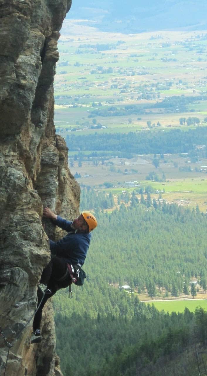
Photo courtesy of Kurt Krueger – Western Montana Climbers Coalition
I was reading Sharon’s post about good and bad businesses and realized the same polarization is now occurring with recreation., and it seems the Bitterroot National Forest is ground zero for this new conflict. The BNF was the only Region One forest to ban bikes in both Recommended Wilderness and now it is instituting a forest-wide moratorium on sport climbing route development.
“With the sport of rock climbing growing dramatically across the West, the challenge on how best to manage all those new enthusiasts to protect the resource is an issue other national forests are beginning to ponder.
The controversy over the increase in rock climbing on the Bitterroot Forest has been a decade or more in the making.
It mostly centered on a popular climbing area in the Mill Creek area where climbers used rock drills to put in hundreds of permanent anchors to create popular sport climbing routes on what climbers called the Tick Wall.
With the sport of rock climbing growing dramatically across the West, the challenge on how best to manage all those new enthusiasts to protect the resource is an issue other national forests are beginning to ponder.
“Protect the Selway-Bitterroot Wilderness and WSAs from unlawful and unauthorized bolted climbing routes!
Recently, officials at the Bitterroot National Forest (BNF) took steps to protect the national forest, including the Selway-Bitterroot Wilderness and two congressionally designated Wilderness Study Areas, from a massive influx of climbing use that is damaging resources and elevating social conflicts.
The BNF issued a news release reminding climbers that it is unlawful for visitors to develop new climbing routes or trails or install “permanent hardware or apparatus such as bolts, glue, manufactured hand holds; or modifying routes through chipping, cleaning, hammering, or drilling new or existing holds,” on climbing routes while work proceeds on a forest-wide Climbing Management Plan (CMP). It’s a common-sense “time-out” approach that allows climbing to continue while minimizing further damage until a comprehensive climbing plan can be developed with public input and environmental review.
Sadly, a local climbing organization and the national Access Fund have launched a campaign urging the Forest Service to remove the protections, arguing that—get this— the agency shouldn’t take any action to stop the escalating damage until after the environmental review process has been done!”
“The ban was issued as an official order by Forest Supervisor Matt Anderson, and it declares all new route development (first ascents) after the date of the order illegal. The order does not include any allowances for emergencies, fixed anchors that protect natural resources, bolt replacement, first ascents with no fixed hardware, hand-drilled fixed anchors on new routes in Wilderness, or slings for descent. Of further concern, the Supervisor’s Order “reminds” climbers that new fixed anchors are banned—incorrectly implying that fixed anchors were illegal in the past. This implication is at odds with well- established U.S. Forest Service plans across the country, which acknowledge fixed anchors as critical tools for climbing.
“We haven’t seen a U.S. Forest Service decision as egregious and far-reaching as this in 25 years,” says Access Fund Policy Director Erik Murdock. “This Supervisor’s Order overrides a successful, existing agreement between the climbing community and the forest, ignores any public process, and sets a dangerous precedent for all national forests.”
Access Fund is working with Western Montana Climbers Coalition (WMTCC) to push back on this unsubstantiated ban and remind Bitterroot National Forest that fixed anchors are legal in national forests. Perhaps more importantly, we’ll be reminding the supervisor that a significant management decision like this, on our public lands, deserves public process and science-based decision-making. Learn more about this issue and past work with Bitterroot National Forest.”
The reference to science-based decision-making made me think of an opinion piece in the Missoulian here on the evils of collaboration,
“Collaboration is not about right and wrong or about intrinsic values. It’s a cop-out on the part of environmental groups that sully their reason for existence in order to be politically correct.
Ultimately, it’s a process that gives validity to those whose activities are either illegal, incompatible or so damaging to public resources that they have been or are being restricted for that very reason. Within normal data- and science-driven decision-making processes of land management agencies — the goal thereof, anyway — these peoples’ views lack substance and shouldn’t be incorporated into management…
Thus comes “collaboration” to justify misuse of the landscape. Best management practices, using science and best available data, don’t allow high-impact users the unlimited access they desire to meet self-centered, short-term recreation desires…
A Montana example of how wrong this now-popular approach to addressing land management via collaboration is exemplified by the Gallatin Forest Partnership. The Gallatin Range, adjacent to Yellowstone National Park, is a keystone of the Yellowstone ecosystem, the last essentially intact temperate ecosystem on our earth. There is nothing more short-sighted than to undermine environmental protections on an integral part of one of the original dozen World Heritage Sites to please users who have no appreciable respect for the global importance of this ecosystem or the future of what little remains of our natural heritage”.
At this point let me start winding my way back to the issue of good and bad recreation. The Gallatin Forest Partnership that so raised the hackles on the above writer was a collaborative agreement between non-motorized recreation groups and conservation organizations for management of the Gallatin National Forest in and around the Hyalite- Porcupine-Buffalo Horn Wilderness Study Areas. The issue the writer most likely has issue with, but only obliquely referenced,”high-impact users the unlimited access they desire to meet self-centered, short-term recreation desires“ was continued mountain bike use in areas where it is already established and recommending the remainder for wilderness designation rather that recommending the entire area for wilderness designation.
Although the writer says this is about science and not about values, he sure makes a lot of value judgments about the recreational users he opposes. They are self-centered.
Their views lack substance. Their use is incompatible with public resources. Furthermore they, presumably mountain bikers, have no “appreciable respect for the global importance of this ecosystem.” As far as the science, I’m not sure there is any evidence the wilderness designation is superior to Inventoried Roadless Areas, Recreational Areas, or Wildlife Management Areas. Most of what I have read references the need for roadless areas. As far as wildlife, there is some evidence that mountain bikes may cause more stress on elk than hikers in certain situations. It does not necessarily indicate that bikes are more impactful than supposedly low-impact and approved uses such as hunting or outfitters. What about economic impacts? Should the economic benefits of outdoor recreation be ignored? What about the mental and physical health benefits of getting outside in nature and having fun? The evidence is clear that it is beneficial for the individuals. Should this science be ignored? If these area are closed to recreation, will be people drive somewhere else, increasing their carbon footprint, or will they change activities and still be out in the forest still causing an impact? I think most studies have shown people will drive somewhere else to engage in their preferred activity.
Before I finally get back to the Bitterroot, one more quote from Wilderness Watch in opposition to the imposition of fees in Oregon Wilderness Areas,
““There is something amiss when an American citizen has to pay a fee to hike on their lands, which are really our birthright, not a commodity to be ‘sold,’” said George Nickus, executive director of Wilderness Watch.”
So this brings us back to the Bitterroot and good and bad recreation. First, a little information on the Bitterroot National Forest. Currently half of Ravalli County is National Forest and half of the BNF is designated Wilderness, mostly the Selway/Bitterroot, but also portions of Welcome Creek and the Anaconda/Pintlers. To the best of my knowledge, there no demand for bolting or the development of sport climbing routes in either the Blue Joint or Sapphire WSAs. I confirmed this with climbers coalition. Blue Joint is over 50 miles away from the area of contention in Mill Creek and the Sapphires are in a separate mountain range. The main climbing area is one mile for the trailhead, and despite the hysteria, it will not be confused with the lines in Eldorado Canyon waiting to climb the Bastile.
It seems everyone wants decisions to be science-based, but it becomes clear fairly quickly that science will not give us the answers. There is also not much room for compromise when one side is accusing the other of unlawful and unauthorized behavior. What baffles me somewhat is why the Bitterroot? Any day of the week the trails and lands around Bozeman, Missoula, Whitefish, Jackson are far more packed with people. Last year I saw more people on one backcountry ski tour outside Big Sky than I have seen in a year of biking and backcountry skiing here. Maybe it is because it still relatively quiet. Maybe it is because Stewart Brandborg who lived here in the valley espoused a no compromise ethos later in his life. Is the demographics: young vs. old, or newcomers vs. old timers? Is it because the valley is still rural and mostly conservative? My theory is, it’s the political non-viability of major wilderness designations. Occasionally you can get a wilderness for no-brainer areas like the Rocky Mountain Front, but the odds of ever getting a wilderness designation for the WSA or any significant portion of the recommend wilderness makes these designations life or death decisions for many people in the wilderness community. No one has attempted to get the WSAs in the Bitterroot congressionally designated wilderness since around 1990. (Tester did proposed some additional wilderness in the Beaverhead portion of the Sapphire WSA, but that bill died.) Same thing for any the recommended wilderness along the Bitterroot Front. As the possibilities for congressional support have dimmed, the desire, or depending on one’s point of view, the necessity, of getting the Forest Service to do what Congress won’t has become non-negotiable and any potential threats to the creation of de facto wilderness needs to be fought with all possible means.
Lance Bysher is a skier, biker, boater, hiker, rusty climber, all around lover of outdoor recreation and current president of the Bitterroot Backcountry Cyclists.
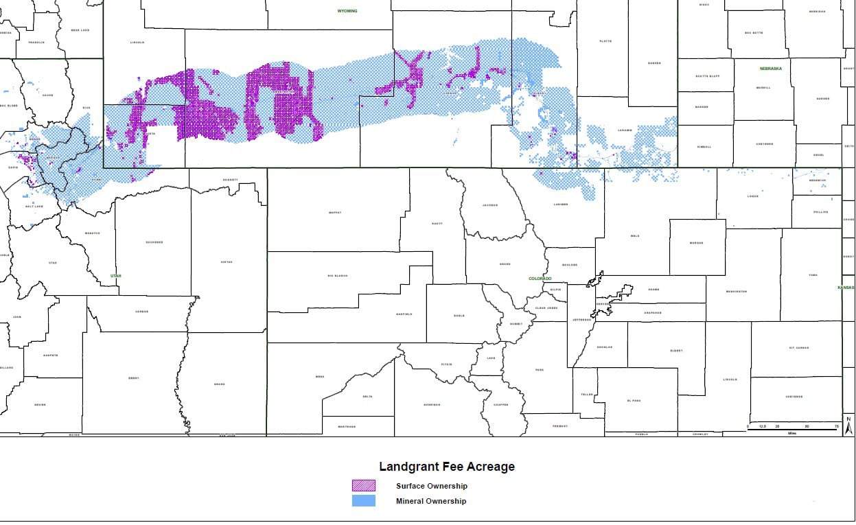
Map from the Governor’s Office via Wyofiles. For those of you who can’t read county names, yes, parts are in Utah and ColoradoFollowing up on the Grand Teton Park aerial goat-shooting story here, it appears that the Governor appealed to David Bernhardt the Secretary of the Interior after repeated letters from the head of Wyoming Game and Fish had no impact on the federal decision. Here’s a link to the Cowboy State Daily.
Bernhardt’s order to “stand down” came in a phone call to Gopaul Noojibail, acting Grand Teton Park superintendent late Friday. The call was made after Governor Gordon shared with Bernhardt a strongly-worded letter sent to Noojibail Friday afternoon. In the letter the Governor criticized the Park Service’s choice to “act unilaterally aerially executing mountain goats over the State of Wyoming’s objections.”
Perhaps there must be an interesting backstory there.
In other Wyoming news, state legislators are looking at buying a million acres (yes, a million!) of land.
Here’s a link to a story about it, and a statement by the Governor here (excerpts below) in the Cowboy State Daily:
Wyoming is not looking at this purchase to try to become a developer or a mining company; rather, we see the land grant opportunity as a way for the state to expand the areas where we already have expertise: land and mineral management.
This opportunity is not just about the money. This acquisition has enormous potential benefits for multiple-use that are valuable to all citizens of Wyoming, giving us the opportunity to assemble one of the largest contiguous pieces of public land in the continental United States. One that will benefit wildlife, hunters, fishermen and outdoor recreationists while achieving responsible development of rich natural resources.
Opportunities like this don’t come along very often. The land grant has only changed hands twice in its 150-plus year history. It’s likely that this would be the largest government purchase of private land since the United States purchased Alaska. That’s a big deal.
In this interesting article by Cat Urbiquit (who doesn’t seem to be a fan of the purchase), she talks specifically about how public public lands are in terms of recreation. Apparently Wyoming State Lands may be more restricted in terms of recreation than multiple-use federal lands such as BLM and FS. I think what is also interesting is the difference in terminology between “public” lands “owned by a government entity of some kind” versus “open to the public for various uses or not.” In many discussions people use the word to mean different things, which could contribute to the phenomenon of talking past each other.
State trust lands are to be managed to produce revenue, so they aren’t comparable to federal “public” lands like that of the Bureau of Land Management that are to be managed under a multiple-use mandate. But the State Land Board has adopted rules allowing the “public the privilege of hunting, fishing, and general recreational use on state trust lands.”
Recreational privileges on state trust lands come with sideboards: the lands must be legally accessible, and off-road use, overnight camping, open fires, and anything else that would damage the property are prohibited on state trust lands.
So you can hike, fish, and play on state trust lands by day, but no camping, fire pits, or charcoal grills (except in camping areas established by State Land Board). Cultivated croplands on state trust lands are not open to public use.
The state may issue permits for furbearer trapping and outfitting/guiding on state trust lands, (either exclusive or nonexclusive), and outfitters may be allowed to establish camp sites on exclusive permits.
Some state trust parcels are closed to all public use, while others have seasonal restrictions on public use, or restrictions on the discharge of firearms, hunting, or the use of motorized vehicles.
I originally read about this in the Wyoming Livestock Roundup, and then searched online for other information. I only found it on hunters’ and livestock sites and some local papers in Idaho and Montana, so perhaps deserves further distribution. This seems like a win-win for everybody.. except there might be more recreation environmental impacts by adding recreational access. I don’t know if anyone’s worried about that. Everyone seems to support the LWCF.
The U.S. Department of Agriculture’s Forest Service is seeking public assistance to help identify national forest and grassland areas where the agency can provide greater access to hunting, fishing, and other recreational opportunities.
The agency today posted a draft list of about 90,000 acres of Forest Service land where hunters, anglers, and other recreationists are allowed but have limited or no legal access to the areas. The outreach is tied to agency efforts to implement the John D. Dingell, Jr., Conservation, Management, and Recreation Act of 2019 that mandates federal land management agencies work to evaluate how to expand access to public lands.
The Forest Service is seeking nominations that describe federal lands not on the list. The lands identified must be managed by the Forest Service, be a minimum of 640 contiguous acres, and be unreachable by foot, horseback, motorized vehicle or nonmotorized vehicle because there is no public access over non-Forest Service land, or the access is significantly restricted.
“National forests and grasslands play host to some 300 million hunters, anglers, and other recreationists each year,” said Forest Service Chief Vicki Christiansen. “The input we receive will go a long way toward helping the Forest Service provide even greater access and opportunity for the people we serve.”
The public nomination period to identify parcels for inclusion on the agency’s priority list will close on March 12, 2020. A final priority list will be published soon after and will be updated at least every two years until 2029.
To nominate a parcel of Forest Service land for consideration, email [email protected] or write to Lands and Realty Management, ATTN: Access Nominations, USDA Forest Service, 1400 Independence Ave. SW, Washington, DC 20250-1111. Nominations must include the location of the land or parcel, total acreage affected (if known), and a narrative describing the lack of access.
*****************
Background
The John D. Dingell Jr. Conservation, Management, and Recreation Act of 2019 is a broad-based law that sets provisions for various programs, projects, activities, and studies in the management and conservation of federally managed natural resources. The law includes steps agencies must take on how federal acres that are now essentially inaccessible may be opened to the public. The collective work of the Forest Service and interested citizens will help the agency decide how to reasonably provide access through such measures as easements, rights-of-way, or fee title from a willing landowner.
********************
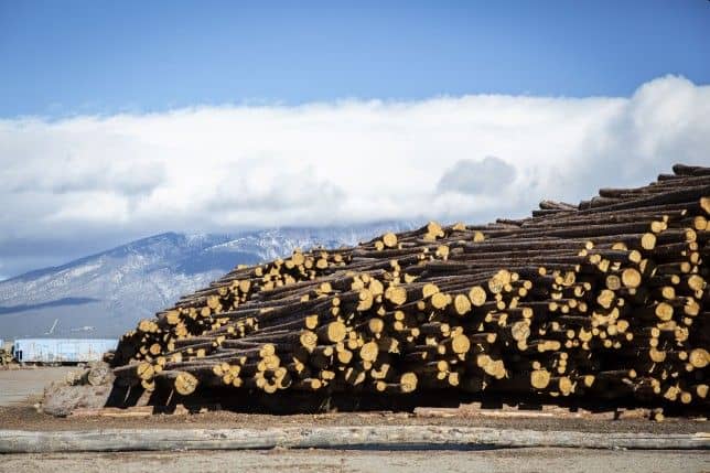
Logs taken from the Trinchera Ranch wait to be processed at Blanca Forestry Products, a sawmill outside of Blanca, Colorado on Wednesday, Dec. 19, 2018. The mill employs some 70 people. Nathaniel Minor/CPR News[/captions] This is the mill billionaire Louis Bacon, owner of the 172,000 acre Trinchera Ranch in Colorado, built to process material from the ranch. Here’s a link to the story.
The New York Times did a story here on rich people buying up and blocking off land in the Interior West. This is not news to us, but they have some interesting perspectives. Here is the story.
Some of the new owners have been welcomed. The cable magnate, John Malone, for instance, has been praised by the Nature Conservancy for his family’s conservation efforts, and other buyers have helped to clean up trails and restore pristine acres.
The arrival of this new class of landholders comes as the region is experiencing the fastest population boom in the country, which is driving up housing prices and the cost of living and leaving many residents fearful of losing their culture and economic stability.
In Idaho, Rocky Barker, a retired columnist for The Idaho Statesman, has called the conflict a “clash between two American dreams,” pitting the nation’s respect for private property rights against the notion of a beauty-rich public estate set aside for the enjoyment of all.
The clash, he said, is part of a larger transformation of the region — from an economy rooted in extraction to one based on recreation; from a working class culture to a more moneyed one. “Big landowners,” he said, “are just another new force.”
In the intermountain West, the purchases come amid a population boom that has exacerbated local concerns about the loss of space and culture. Last year, Idaho and Nevada were the fastest growing states in the nation, followed closely by Utah, Arizona and Colorado.
These new buyers have become a symbol of a bigger problem: The gentrification of the interior West.
In 2018, more than 20,000 Californians arrived in Idaho; home prices around Boise also jumped 17 percent. This has meant not just new subdivisions and microbreweries, but also packed schools, crowded ski trails and heightened anxiety among teachers, plumbers and others, who are finding that they can no longer afford a first home.
Many landowners are engaged in conservation and have entered into easements that limit future development on their parcels, and also provide them with significant tax breaks.
But setting aside land for conservation has not always staved off criticism.
In Idaho, the Wilks brothers did more than gate a few roads. They also revoked road-use contracts that propped up the region’s multimillion-dollar snowmobile industry, shut down hunting on their land and told timber companies to pull crews from the area. About 100 people lost their jobs.
No one claimed that those actions were illegal, but they heightened fears that local residents were losing control of the region. A 2017 video of a roadside argument between an armed Wilks guard and a local ATV rider traveled quickly around the state.
What is interesting to me about this is
(1) the idea that rich people buying private land and blocking access is bad (timber, snowmobiles and ATVs), but efforts to block the same activities on public lands (e.g. a certain National Monument) are good, because it’s good for the environment and ATVers tear up the landscape and so on.
(2) Maybe “rich people ownership” is good for the environment as the property won’t be recreated upon by lots of people nor subdivided?
(3) Also, perhaps part of the reason some in San Juan County are not fans of Monumentizing Bears Ears has to do with not wanting gentrification nor a “more moneyed culture.” Here’s a link to two points of view on urban gentrification (is it saving or ruining LA). Do the arguments sound familiar?
It is a time-tested and popular model. A private landowner is willing to sell land or conservation easements to the government. A third party conservation group steps in to provide bridge funding and/or ownership until the government can fund the purchase. In this case, involving the Rocky Mountain Elk Foundation as the intermediary:
“The project, which was in its very early stages, would provide some valuable new access points in the area as well as protection from development along a stretch of Sheep Creek, a tributary of the Smith River, he said. In addition to the 4,000 acres purchased and then resold to the Forest Service, the checkerboard pattern of land ownership would mean access to an additional 7,000 acres of public land.”
While Meagher County (pronounced “mar”) doesn’t have any authority to influence the deal, it is attempting to do so by issuing a resolution opposing it, citing “potential loss of tax revenue, issues with federal land ownership and management, and the question of whether a land swap could open access without expanding federal land ownership.” The resolution says, “that the commission respects private property rights and supports tourism but continues to oppose expanded federal ownership.” (Funny that they don’t mention elk hunting/hunters, which has to be a key benefit.) Their opposition may affect how the project competes for funding, and whether RMEF wants to stay involved.
The Forest Service, to its credit, is looking out for the “greatest good” and not bowing to nimbyism or political ideology.
“We acknowledge Meagher County’s resolution and recognize their position regarding the Holmstrom Sheep Creek proposal,” said Lisa Stoeffler, acting forest supervisor. “We appreciate that our working relationship with the commission allows for open discussions, especially related to increased recreational public lands access and the improvement of crucial fish and wildlife habitat conservation areas within the county. The Forest plans to submit two project requests for LWCF funding, one of which will include Holmstrom Sheep Creek. In our request packet, we will fully disclose the Commission’s resolution regarding the project.”
These have normally been seen as “white hat” projects in the past, but under this Administration, the Forest Service may find out that white is the new black.
In 1866, the Mining Act included this provision (now known as RS-2477): “the right of way for the construction of highways over public lands, not reserved for public uses, is hereby granted.” What this means and how it is applied has become an issue with local governments in recent years where federal land managers have wanted to reduce roads or limit access. It generally means that if a road predates the establishment of a National Forest, the Forest Service can not interfere with valid uses. The process requires a quiet title action in federal claims court.
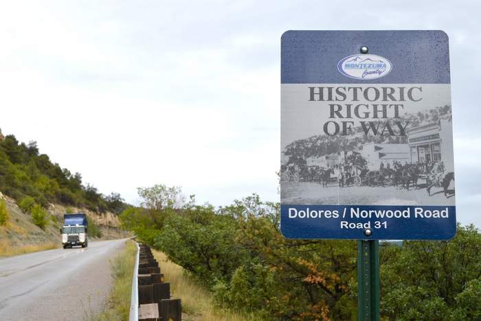
Hereis a recent battle brewing in Colorado, where one county is actively seeking jurisdiction over 17 roads and trails in three counties, one of the trails being targeted for closure to motorized uses through the San Juan National Forest Travel Plan. Another county wants nothing to do with it. Montezuma County believes it has maps that prove its case, but the Forest Service disagrees. Here is their response:
If the information relying on maps is the only county proof that the roads and trails qualify for RS2477 status, then “the basis for the resolution is insufficient,” Padilla wrote.
He said the Forest Service is not against evaluating RS2477 assertions, but that the county bears the burden of proof.
“I know the county believes the converse is true, but that is not supported by current law, policy or regulation,” Padilla stated.
The national forest sees the county’s RS2477 resolution as nonbinding.
Routes currently designated as nonmotorized or are closed for public use will continue to be managed that way until the county validates their assertions through a legally recognized process, Padilla said.
“This means that violators would continue to receive citations,” he said.
Padilla added that there are current cases to support this position, including one in San Juan County, Utah, that involved county commissioner Phil Lyman, who received a ticket for driving an ATV on a nonmotorized route during a protest ride.
Where Dolores County disagrees is whether the Forest Service will “fight it,” which affects the cost side of the ledger for the counties. I’m not aware that DOJ has ever conceded a RS-2477 case where the land management agency disputed the existence of the right-of-way. But under this Administration, maybe Dolores County is wrong in thinking they should not “deceive ourselves that routes will just be given to us.”
ANILCA provides: “Notwithstanding any other provision of law, and subject to such terms and conditions as the Secretary of Agriculture may prescribe, the Secretary shall provide such access to nonfederally owned land within the boundaries of the National Forest System as the Secretary deems adequate to secure to the owner the reasonable use and enjoyment thereof: Provided, That such owner comply with the rules and regulations applicable to ingress and egress to or from the National Forest System.” 16 U.S.C. § 3210(a)
“The U.S. Forest Service is currently considering approval of a new two-lane paved road across public lands north of Edwards to facilitate development of Berlaimont Estates — 19 new mansions, 2,000 vertical feet above town. The sprawling subdivision would be developed on a parcel that is completely surrounded by National Forest.
Unlike other nearby neighborhoods (e.g., Wildridge and Mountain Star), public land managers must approve a new road across lands owned by you and me to facilitate this proposal. To approve the new road, the Forest Service must deem Berlaimont Estates a “reasonable” land use.”
How does the White River National Forest determine what is a reasonable use? Dose it matter what the surrounding use of the national forest is? Does it matter if it creates bigger WUI problems? When you buy a piece of land surrounded by public lands with no access is it reasonable to expect to build a subdivision?
These questions are intertwined (and sometimes conflated) with the question of whether the “regulations applicable to ingress and egress” (access) are reasonable. Should the Forest Service be able to say that the proposed “32-foot wide, bermed, walled, plowed and paved thoroughfare switchbacking thousands of feet up a very visible hillside,” where “the walls necessary to support this road could be more than 1,000 feet long and as tall as 40 feet” is not reasonable? The Forest Service has been upheld when it limits the kind of access to inholdings. And by the way, “The 2002 Forest Plan designated this area Deer and Elk Winter Range and restricted winter use to minimize disturbance.” It seems like a road with lots of use on it might be inconsistent with the forest plan.
It’s probably unfortunate that the local land use plan either allows a subdivision here or there isn’t any local planning. It is Forest Service policy to get involved with that process, in part to help it deal with these hard questions.
Sometimes the threat to national forest access results from undeveloped private land adjacent to a national forest becoming a subdivision, and here’s an example of that.
In a recent development (described on a subscription-only site) an Aug. 28 hearing has been set in a lawsuit filed by developer Easter Mountain Ranch LLC (EMR) against Cochise County, Arizona. The county board had denied approval of a tentative subdivision plat for J6 Ranch, a 278-home gated community planned for the northern foothills of the Whetstone Mountains. The land to be subdivided abuts the Coronado National Forest. The issue in the case boils down to a requirement by the county for the developer to “provide multi-purpose (vehicle, pedestrian, equestrian, etc.) legal access to federal lands.” The proposed subdivision would provide a road that dead-ends at the boundary of the national forest where roads are not allowed.
While the lawsuit about whether the developer met this requirement may hinge on the meaning of “access to,” the question I have is what is the Forest Service position and what has their involvement been. They are not mentioned here. It seems likely that the county position was an effort to coordinate with the Forest Service, and what exactly that meant should have been on the table for all parties to understand. But where was the Forest Service? (There’s nothing on the EMR or J6 Ranch on the Coronado website.)
Then I wonder about what kind of public access will be allowed through a “gated community.”
Yes, it looks like Forest Service employees should be concerned about how Trump might affect their careers. Here’s an example about offending private landowners who block access to national forests. (And, without any facts beyond earlier stories, I’ll suggest that you not think of these as long-term rural residents, but more likely some recent, possibly seasonal transplants, with money and political connections.)
Such cooperation, however, changed under the Obama administration as the Forest Service took a more strident approach in asserting claims to “traditional public access” routes. The dramatic change is reflected in a posting by Yellowstone District Ranger Alex Sienkiewicz who publicly advocated “NEVER ask permission to access the National Forest Service through a traditional route shown on our maps EVEN if that route crosses private land. NEVER ASK PERMISSION; NEVER SIGN IN. … By asking permission, one undermines public access rights and plays into their lawyers’ trap of establishing a history of permissive access.”
According to Sienkiewicz and access advocates, traditional public access is sufficient to establish a legal right, known as a prescriptive easement, to cross private property. Centuries of legal practice, however, have required that individuals or agencies wanting to establish prescriptive easements must prove that access was continuous, open, notorious, and hostile to the owner. In other words, the access must be without expressed permission by the landowner, a burden of proof that has been difficult, to say the least.
This doesn’t sound like the complete story. The federal government does try to protect its existing legal interests, and that includes historic access that may not have been formalized, which it tries to negotiate. I doubt if it often pursues litigation, but does sometimes end up in court to defend public access, as in this case involving access to the Lee Metcalf Wilderness on the Indian Creek trail, cited by the author of the op-ed above as a good example of negotiation (at least until it apparently went bad). The Forest Service met its “difficult” burden of proof in this case. There is a risk that asking permission now could undo the historic rights that already exist, but I don’t think it’s large, and I am a little skeptical that the Forest Service would “post” statements like that above except in cases where a particular landowner had made it clear that they were declaring war on public access, such as in this example.
Recently, the U.S. Forest Service removed District Ranger Alex Sienkiewicz from his position in the Yellowstone Ranger District pending an internal investigation into his efforts to defend historical Forest Service trails and easements along the Crazy Mountains.
When legal access to public land does exist, I believe Montanans fully expect the Forest Service to defend and maintain that access for Montanans. As with so many of these issues involving political pressure on public agencies, a look behind the curtain reveals a very troubling story. According to media reports, U.S. Sen. Steve Daines, and Congressman Pete Sessions from Houston, Texas, both contacted Agricultural Secretary Sonny Perdue regarding Sienkiewicz’s efforts to protect legal, established accesses to landlocked public lands. According to Mary Erickson, forest supervisor, “the reassignment was made after allegations from an assortment of landowners in the Big Timber area were raised to the level of the Secretary of Agriculture, Sonny Perdue, and Sen. Steve Daines.“
Blocking and posting no trespassing signs at the head of Trail 115/136 prompted Yellowstone District ranger Alex Sienkiewicz to organize a trail clearing and marking trip this past summer. Prior to that the agency traded letters with the Langhuses’ Livingston attorney, Joe Swindlehurst, who has denied there is an old forest trail at that location.
It’s not a stretch to see this as politicians ordering a personnel move to keep public lands from public hands. Dangerous on both counts.