Jim Furnish on the Forest Service past and future.
climate change
Yosemite Visit
I recently spent three days in the Yosemite National Park area, shooting each day, in different locations. Yes, I did find a marvelous group of dispersed camping sites (free!) within the Rim Fire perimeter. Of course, they were there before the fire but, those spots still look great. Yes, there are also patches of high-intensity burn along Hardin Flat Road (the old highway) that have been salvage logged, too.
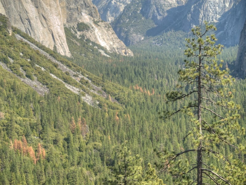
One of the places I went to, inside the park, was a large patch of high-intensity burn, all around Hodgdon Meadow. The campground wasn’t really impacted much by the fire. All around the fringe of the large meadow were green and healthy trees. They should be a good source of seeds, and it looks like most sugar pines had an excellent “cone year”. The problem will be the inevitable re-burns, with heavy fuels from trees like these:
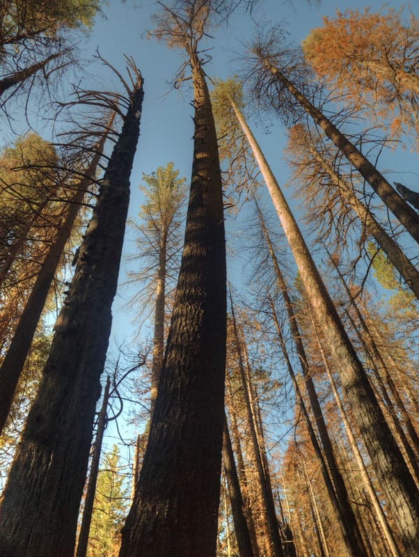
Yes, there are some tufts of green up there but, will the trees be able to fight off drought and bugs, with damaged cambium? Probably not. Yosemite has become a giant incubation “Motherland” for bark beetles, who don’t stay inside the lines on the map. However, I would recommend Hodgdon Meadow Campground (right near the Highway 120 Entrance Station) for your visit to Yosemite. There is something very primitive to camping under such giant trees (non-Sequoias).
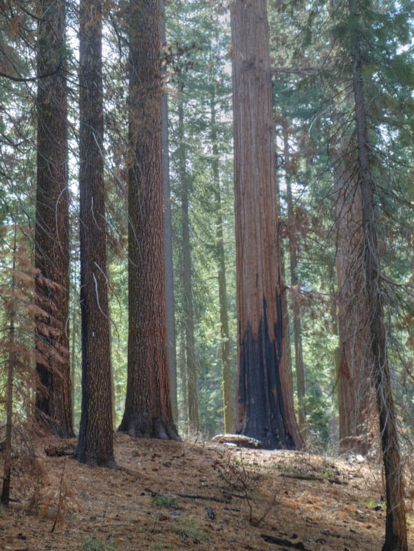
Speaking of Giant Sequoias, I dropped into the Tuolumne Grove, to see how the Rim Fire impacted the area. I knew that firefighters had set up sprinklers, and I could tell by looking at the Google Maps view that there wasn’t much intensity there. This area (pictured below) was about as scorched as much as I could find, along the trails. Certainly, nothing to worry about. I’ll bet there is more insect mortality in the area than fire mortality. I’m sure that some will say they wished it had burned a little more intensely. Most of the grove didn’t burn nearly as well as in this picture.
I went to Foresta, to view last year’s re-burn and the progress of “recovery” of the Yosemite side. Here are some views of that situation:
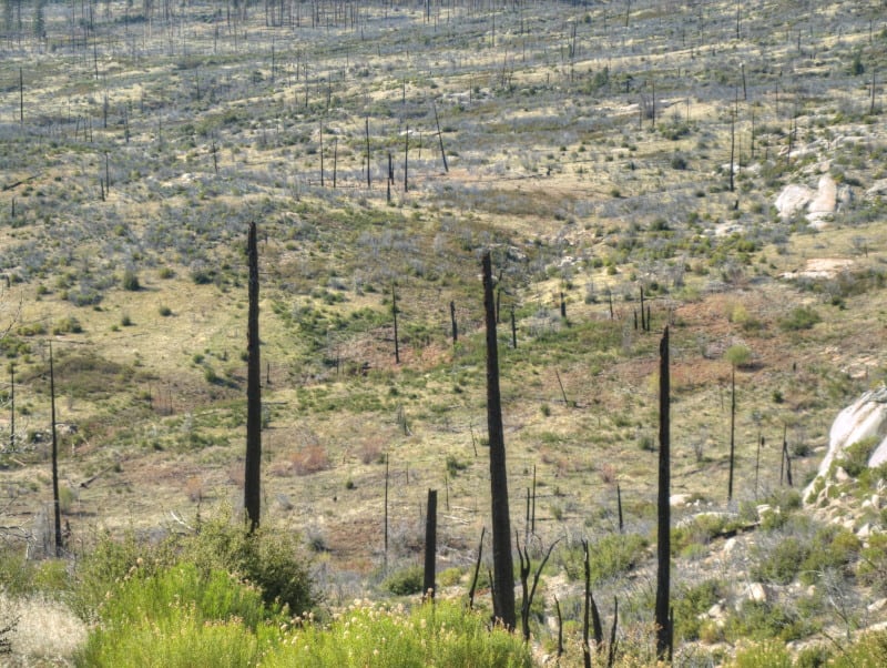
Nine years after the re-burn, and 25 years after the original A-Rock Fire, this area remains desolate. Even brush is having a hard time growing, in soils with very little organic matter. The soils dry out and growth stops, during the hot summers.
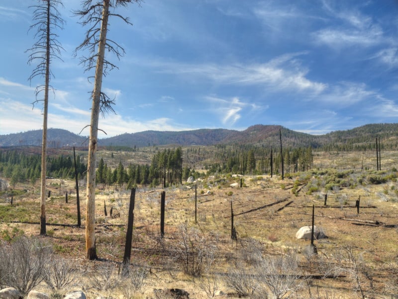
Looking westward, you can see last year’s re-burn, mostly on the Forest Service lands outside the Park. I worked on the original A-Rock salvage project, way back in 1991. I still have some Kodachrome slides from those days, up on that long ridge. The snags in this view probably survived the A-Rock Fire but not the Big Meadow Fire.
Yes, I did go into Yosemite Valley and found some uncrowded hiking along the Merced River.
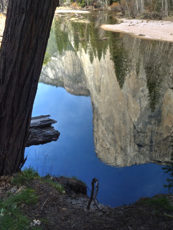
I did see some significant pine beetle patches, in Yosemite Valley. It seems like a “normal” level of bark beetles, considering the horrible drought, and all.
There is a lot more to see over on my Facebook page www.facebook.com/LarryHarrellFotoware
The Forest Service as Noah
High-elevation headwater streams that provide refuge for native bull trout and cutthroat trout would remain cold enough even under the worst warming scenarios to protect and support them. These streams, in places like Central Idaho’s White Cloud Mountains, can carry these native trout through the global warming bottleneck – when many species will disappear – that scientists say the world faces even if nations are able to stop the rise in greenhouse gases. “They are like Noah’s ark for bull trout and cutthroat,” Isaak said.
In February, Isaak and Young briefed forest officials and others working collaboratively across Idaho to restore the health of forest ecosystems while providing jobs for rural communities. The briefing gave local land managers like those on the Boise National Forest a chance to see how their plans fit into these “climate shields.” “There were a few areas in the Lowman District and in the upper Boise,” said David Olson, a Boise National Forest spokesman.
Said Isaak: “The hope is that the information provides a strategic tool that can be used to make more efficient local investments in stream restoration and protection projects, so that the broadest possible distributions of cutthroat trout and bull trout remain later this century.”
Isaak’s Noah’s ark approach won’t just help aquatic species, but also can help managers determine what other habitat will remain viable as warmer winters, earlier runoff and increased wildfire accelerate with warming temperatures. Wolverine biologists are looking at many of the same areas, Young said. Pika, lynx and other mammals that depend on cool summers or good snowpack may find refuge in Idaho’s high country.
This story describes a concrete step towards being strategic about climate change by identifying areas that should be used to build the ‘ark.’ Unfortunately, it doesn’t make the connection to national forest plans, where strategic choices about management priorities need to be made. It will be interesting to see how the Nez Perce-Clearwater forest plan revision incorporates this strategy.
Los Padres National Forest
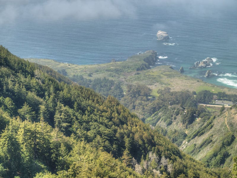
While on an overnighter in Big Sur, I was amazed at how big some of these sycamores were. Even the old growth redwoods look pretty small, compared to these giant hardwoods. The leaves are about as big as your hand, so there your frame of reference. These trees are actually within the Pfeiffer Big Sur State Park.
While there are some recreation facilities along Highway 1, they are fee areas. In many of those places, there are wide spots in the road, where it is easy enough to just walk in, without paying the fee. However, “dispersed camping” is not allowed, along the highway, on Forest Service lands. I did some Google Maps researching and found this old road off the State Highway. It was rough and steep but, I somehow found this gem of a spot to camp at, far above the coastline. You can see some drought stress in these forests, as well, with some of those redwood trees a bit yellowish. The oaks are also looking quite ragged, maybe reaching the end of their lifespans.
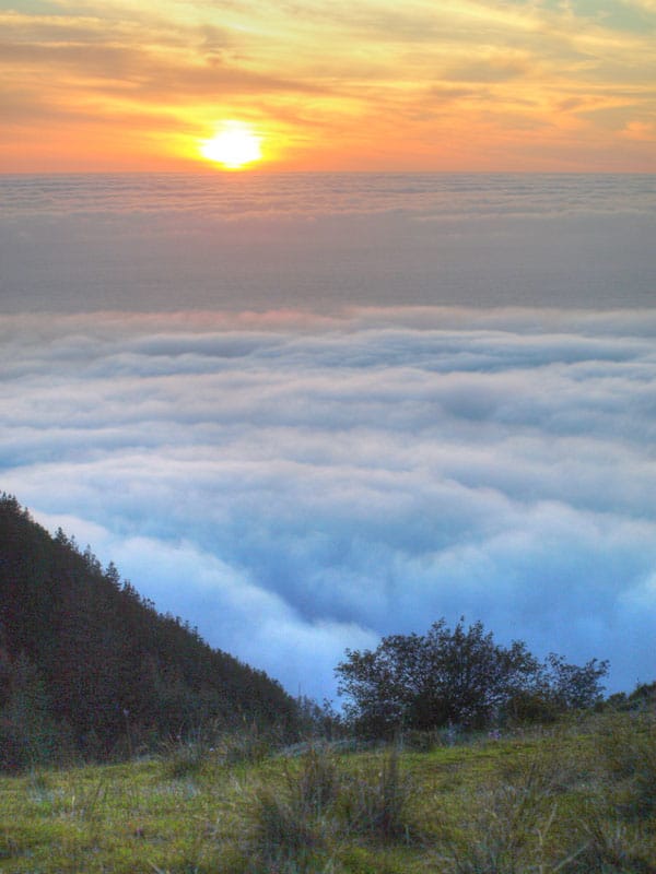
After finding this spot, it freed me up to go explore further southward, almost to San Simeon. I wanted to spend more time near Jade Cove but, I really wanted to be back up in camp, before the fog came in. Yes, the sunset was quite nice.
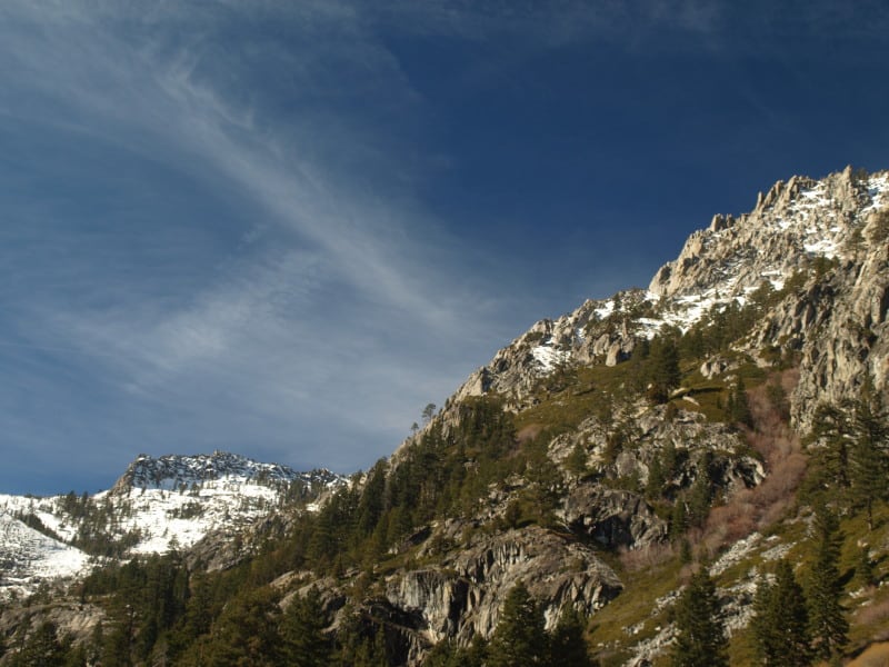
The Tahoe Basin
Lake Tahoe would probably be a National Park, by now, if the Comstock Lode had never been found. There was clearcutting right down to the lakshore, for mining timbers, in the silver mines. Incline Village was named for the switchback road that transported logs to a flume that went all the way down to the Washoe Lake area, thousands of feet below.
Today, there is very little “logging” next to all that blue Tahoe lake water. Newspapers especially like to describe the basin as “pristine”, apparently not knowing the actual meaning of the word.
Much of the Lake Tahoe Basin is “de facto” Wilderness, with very little management happening, even when wildfires occur. Residents seem to be in denial about wildfire issues, not remembering the last drought that decimated their forests. However, it is easy enough to see the results of the last bark beetle infestation, in the form of accumulated fuels far beyond what is “natural”. Many areas of forest mortality were left “to recover”, on their own. Well, sometimes “recovery” takes decades or even centuries, as long as humans don’t intervene. That might also include multiple wildfires, opening the ground to accelerated erosion and having clarity-declining sediments flowing into Lake Tahoe.
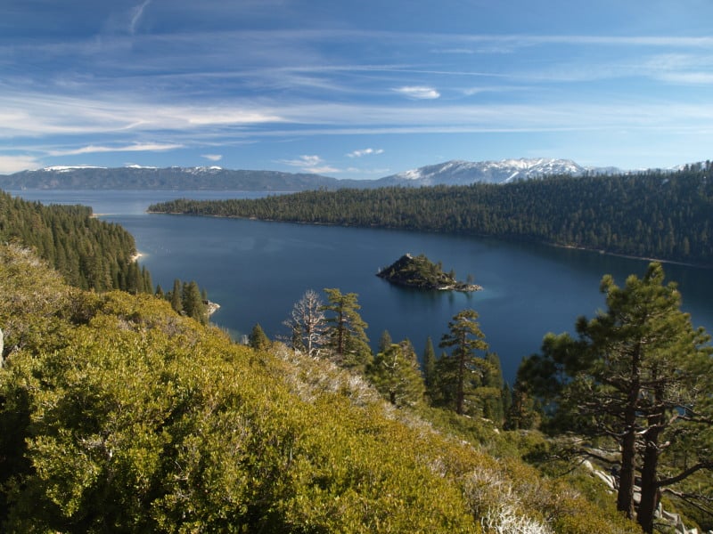
Ironically, the lake’s level isn’t all that far down, thanks to the lobbying of lakeshore land owners, putting pressure on water regulators. That can only go so far, as Reno area interests need more water to keep growing and thriving. We’ll just have to see how the battle goes, as the Truckee River drops further and further.
The Forest Service: Fighting climate change since 1974
(In memory of the Keystone Pipeline)
As you know, the Senate recently voted to acknowledge that climate change is real. In this story, one senator called it ‘a step forward’ for Republicans. What is most remarkable is that they must have been marching backwards since a much wiser Congress passed the Forest and Rangeland Renewable Resources Planning Act in 1974. That law, recognizing “the necessity for a long term perspective in planning and undertaking related national renewable resource programs administered by the Forest Service,” required that the Secretary of Agriculture prepare a periodic renewable resource assessment that must include “an analysis of the rural and urban forestry opportunities to mitigate the buildup of atmospheric carbon dioxide and reduce the risk of global climate change.” (Draw your own conclusions – here.)
California’s Forests: Where Have All the Big Trees Gone?
“The number of trees larger than two feet in diameter has declined by 50 percent on more than 46,000 square miles of California forests, the new study finds.”
“But in comparing a census of California forests done in the 1920s and 1930s with another survey between 2001 and 2010, McIntyre and his colleagues documented a widespread demise of big trees that was evident even in wildlands protected from logging or development. The loss of big trees was greatest in areas where trees had suffered the greatest water deficit.”
If nothing else, this supports a policy of not killing the survivors.
Urgent Action Needed to Save Sierra Forests
This viewpoint shows more of the reasons why the desire to have larger and more intense wildfires, in the Sierra Nevada, is the wrong way to go.
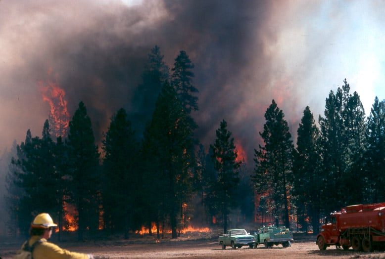
In this picture below, fire crews were run out of this stand, and back into the “safety zone”, on this fire I worked on, back in 1988.
http://www.sacbee.com/2014/09/28/6737076/viewpoints-urgent-action-needed.html
Air quality the past two weeks has been several times worse than some of the most polluted cities in the world due to smoke from the King fire. Last year’s Rim fire emitted greenhouse gases equivalent to 2.3 million vehicles for a year.
Also, the lost habitat and recreational opportunities from major fires like these are significant. It is not an exaggeration to say that virtually all Californians are affected when these “megafires” occur.
The report points out that wildfires are getting larger and burning at higher intensity than ever before. The Rim fire burned at nearly 40 percent high intensity – meaning virtually no living vegetation is left – covering almost 100,000 acres. More acres have burned in the first 4½ years of this decade than in seven decades of the last century.
What can we do about it?
The main bottleneck in treating more acres is in implementation. The Forest Service is unwilling to increase the size of its Region 5 timber management staffs. They use some of the usual excuses, some of which are beyond their control but, not all of those issues are really significant, looking at the big picture. Yes, it is pretty difficult to implement extremely-complex plans when you are constantly training new temporary employees, hired right off the street.
When Trees Go Bad – NY Times Op-ed

Who knew that forests were actually bad for the environment? That should be good news, because we can always use more subdivisions and agricultural land. Let’s check out this recent NY Times op-ed.
First the title…”to save the planet, don’t plant trees.” I get it, it’s hard to write a headline that’s absolutely accurate. I think Matthew and I had a discussion about one of mine a while back. But climate change is only one thing that is bad for the environment. And, of course, “the planet” will actually be fine, with or without trees, humans, or cockroaches. At the worst of potential climate change, we will have made conditions more favorable for some creatures and less favorable for others, including (some of) ourselves. Anyway, ’nuff said on title-pickin’.
Now, like many on this blog, I am not an atmospheric chemist or modeler but I have been observing both forests and scientific idea-slinging for the last long time period. It seems like the idea of the pieces is that “more forests might not be good.” I think it might be hard to argue that “more forests might not be good for climate” without including “converting forests to brushfields or agriculture or homesites might be good for climate.”
Here’s a link to the op-ed and here’s a link to a scientist’s rebuttal. Now it seems that the climate industry is having some big doin’s this week which appears to be why this op-ed showed up.
so let’s just go through the arguments from an observer’s perspective.
In these paragraphs there is some history:
AS international leaders gather in New York next week for a United Nations climate summit, they will be preoccupied with how to tackle the rising rate of carbon emissions. To mitigate the crisis, one measure they are likely to promote is reducing deforestation and planting trees.
A landmark deal to support sustainable forestry was a heralded success story of the last international climate talks, in Warsaw last year. Western nations, including the United States, Britain and Norway, handed over millions of dollars to developing countries to kick-start programs to reduce tropical deforestation. More funds are promised.
Deforestation accounts for about 20 percent of global emissions of carbon dioxide. The assumption is that planting trees and avoiding further deforestation provides a convenient carbon capture and storage facility on the land.
That is the conventional wisdom. But the conventional wisdom is wrong.
“Wrong” is perhaps different from “only true based on our models (?) in some places and not in others.”
The author goes on to explain:
In reality, the cycling of carbon, energy and water between the land and the atmosphere is much more complex. Considering all the interactions, large-scale increases in forest cover can actually make global warming worse.
Of course, this is counterintuitive. We all learn in school how trees effortlessly perform the marvel of photosynthesis: They take up carbon dioxide from the air and make oxygen. This process provides us with life, food, water, shelter, fiber and soil. The earth’s forests generously mop up about a quarter of the world’s fossil-fuel carbon emissions every year.
So it’s understandable that we’d expect trees to save us from rising temperatures, but climate science tells a different story. Besides the amount of greenhouse gases in the air, another important switch on the planetary thermostat is how much of the sun’s energy is taken up by the earth’s surface, compared to how much is reflected back to space. The dark color of trees means that they absorb more of the sun’s energy and raise the planet’s surface temperature.
My first question would be “how “large-scale” do the sums of money we are talking about mean in terms of afforestation? Are we taking, say, the soybean fields of Indiana or the wheat fields of Alberta and converting them to trees? Because if we look down further we find it’s not the Amazon the we are talking about, but rather temperate areas…
Climate scientists have calculated the effect of increasing forest cover on surface temperature. Their conclusion is that planting trees in the tropics would lead to cooling, but in colder regions, it would cause warming.
If this is the case wouldn’t it be logical only to fund efforts in the tropics?
say handed over millions of dollars to developing countries to kick-start programs to reduce tropical deforestation. More funds are promised.
But isn’t that consistent with what was said above? Is anyone planning to give millions of bucks to say, Colorado, or the Ukraine?
The science says that spending precious dollars for climate change mitigation on forestry is high-risk: We don’t know that it would cool the planet, and we have good reason to fear it might have precisely the opposite effect. More funding for forestry might seem like a tempting easy win for the world leaders at the United Nations, but it’s a bad bet.
But that’s not strictly speaking, true is it, if you just spend the bucks in developing tropical countries.????? So confusing!
I actually agree with the author.. I would like the all the climate change funds to go to get poor countries low-carbon energy to bring up the energy availability to the poor people there. But I think you can make that case without maligning trees and their associated VOC’s.
You say ‘HRV,’ I say ‘NRV’ …
Dave Skinner asked, “has anyone besides me noticed the change away from “historic range of variability” terminology to “NATURAL range of variability” in USFS planning processes?”
This terminology is pretty important, but I don’t think the Forest Service has handled it very well. The best source of the Forest Service perspective on this is in the EIS for the planning rule, Chapter 3, pp. 88-91. It recognizes that shortcomings of HRV as a management objective (including the role of climate change), and concludes that, “HRV provides an informative benchmark or reference for understanding landscape change.”
On the other hand, NRV (natural range of variation) is a requirement of the planning rule. A plan must include plan components that maintain ecological integrity (36 CFR 219.8, 219.9). Ecological integrity occurs when “dominant ecological characteristics (for example, composition, structure, function, connectivity, and species composition and diversity) occur within the natural range of variation and can withstand and recover from most perturbations imposed by natural environmental dynamics or human influence” (36 CFR 219.19).
The draft planning directives say that there is no difference between HRV and NRV: “’Natural range of variation’(NRV) is a term used synonymously with historic range of variation or range of natural variation. The NRV is a tool for assessing ecological integrity, and does not necessarily constitute a management target or desired condition” (1909.12 FSH Zero Code definitions). However, if NRV=HRV and NRV is required, then there is a mathematical principle that says plans must plan for historic conditions.
The draft directives then try to create exceptions to the requirement in the regulations that conditions occur within NRV. I think it would be more defensible if the directives define NRV as conditions that would allow an ecosystem or species to “recover from most perturbations imposed by natural environmental dynamics or human influence,” and require an explanation of the rationale (based on best available science) when this is different from historic conditions, or when information about historic conditions is not available.
(Glad you asked?)