Southern Rockies (Colorado) Lynx: Disappearing or Stable? LCAS and the RG Plan

Mapped summer exploratory routes of lynx from Colorado

Matthew posted this about litigation on the Rio Grande plan.

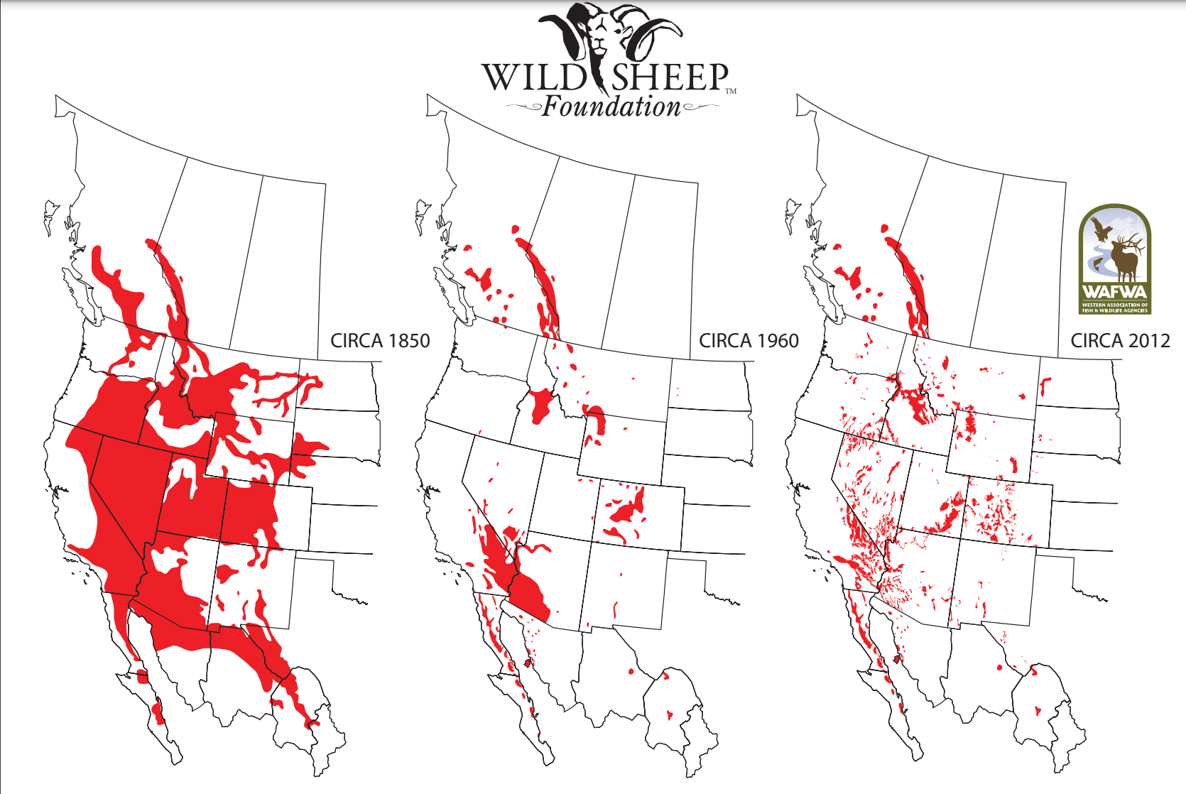
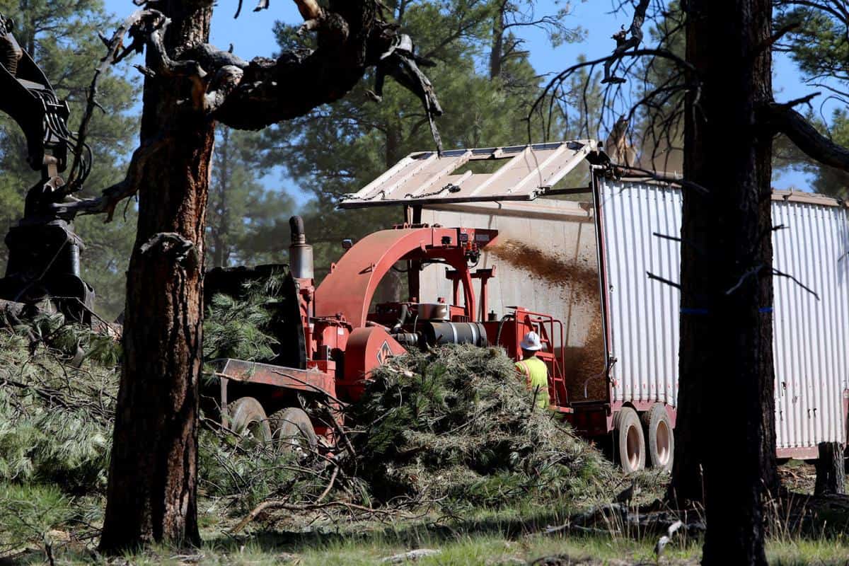
The Canada lynx relies heavily on the Rio Grande National Forest in the Southern Rocky Mountains, which contains more than half the locations in Colorado where lynx are consistently found. But the population is in dire straits, and federal scientists predict that the lynx may disappear from Colorado altogether within a matter of decades. The Forest Service’s new plan has now opened the extremely important lynx habitat in the forest to logging, one of the biggest threats to the cat.

“Scientists are saying the Canada lynx population in the Rio Grande National Forest is in the ‘emergency room,’ but the Forest Service refuses to provide this species with the care it needs,” said Lauren McCain, senior policy analyst for Defenders of Wildlife. “

Since CPW monitors lynx populations, I called them and found that the total lynx population in Colorado is actually stable based on their monitoring. So to say in Colorado RG pops are in “dire straits” does not appear to be accurate, unless there is info somewhere that the RG population is in decline, but it averages out because other pops are expanding (?). It also seems like the LCAS (the statewide lynx forest plan amendment), which has been in existence since 2008, would still be in place under the new RG plan. So if that’s the case (CPW is not the “logging industry” and lynx isn’t hunted, so shouldn’t we trust them?), why would “federal scientists” make those predictions about the species as a whole disappearing from Colorado? Climate change? And yet, if that were the case, why choose southern Colorado for lynx reintroduction? (that was in 1997, so that wasn’t as much of a concern as today).

But.. if you reintroduce species to the southern part of their range, that depend on snowpack during the winter, and then they ultimately have trouble from climate change..is the solution to stop logging? Even with LCAS in place? Ultimately then, it could be argued that anything that disturbs lynx is a threat, and on that basis should be stopped, including, possibly, recreation of all kinds. And yet, with current levels of all those activities, numbers of the species state-wide have remained stable. But we need to do more protective habitat interventions even so, just in case? And what if at the end of the day, we have kept everyone out (and removed developed ski areas) and the lynx still moves north due to climate change?

Here’s the history from CPW:

Colorado represents the southern-most historical distribution of naturally occurring lynx, where the species occupied the higher elevation, montane forests in the state (U. S. Fish and Wildlife Service 2000). Lynx were extirpated or reduced to a few animals in Colorado, however, by the late 1970’s (U. S. Fish and Wildlife Service 2000), most likely due to multiple human-associated factors, including predator control efforts such as poisoning and trapping (Meaney 2002). Given the isolation of and distance from Colorado to the nearest northern populations of lynx, the Colorado Division of Wildlife (now Colorado Parks and Wildlife [CPW]) considered reintroduction as the best option to reestablish the species in the state…

The DOW’s strategy for lynx reintroduction was to first release a number of lynx within a “core reintroduction area” in southwestern Colorado that biologists regarded as the best potential lynx habitat available in the state. Biologists hoped that over time lynx would not only remain in this area long enough to survive and reproduce, but also disperse on their own into other tracts of suitable habitat throughout the state. To this end, DOW biologists began releasing lynx back into southern Colorado in 1999 (Fig. 1). During 1999−2006, a total of 218 wild-caught lynx from Canada and Alaska were released in this core area.

Most interesting to me was this video on Colorado lynx, full of information about them and their lives, plus lots of photos and videos, and their summer explorations, as well as research on lynx and bark beetles, winter recreation, and snowshoe hare density, with CPW scientist Jake Ivan. If you’ve seen a lynx way outside of its habitat during the summer, you might not be imagining things; they go on long walkabouts (to Idaho, Montana and out east) and come back for winter. It’s amazing to me that the telemetry gear does not interfere with lynx activities.

Here’s a link to my previous post on the CPW/FS winter recreation research. I just noticed I hadn’t posted the paper then, here’s a link to an article and several papers.

*************************************************

For more detail, here’s what the ROD for the new RG Forest Plan says about LCAS (page 29 of the ROD):

Southern Rockies Lynx Amendment
The selected alternative uses direction in the Southern Rockies Lynx Amendment Record of
Decision, as amended and modified. The Southern Rockies Lynx Amendment was completed
prior to the spruce beetle infestation and accounts for live, green forested habitat. Standards
VEG S7 (S-TEPC-2) and S-TEPC-3 were added to the land management plan to account for
the increased amount of standing, dead spruce-fir habitat.
The direction incorporates the most recently available information from a study on the use of
habitat by lynx on the Forest (Squires et al. 2018). The direction applies to lynx habitat on
National Forest System lands on the Rio Grande National Forest.
Canada lynx habitat in Colorado primarily occurs in the subalpine and upper montane forest
zones. Lynx show a preference for subalpine fir, Engelmann spruce, aspen, and lodgepole
pine forest types. Recent information demonstrates the close relationship of lynx on the
Forest to particular locations within the subalpine forest zone and their use of specialized
forest structure (Ivan et al. 2014, Squires et al. 2018). Other habitats used by reintroduced
lynx locally include spruce-fir/aspen associations and various riparian and riparian-associated
areas dominated by dense willow, particularly during the summer period (Shenk 2009).
The Southern Rockies Lynx Amendment identified four linkage areas on the Forest that
remain important areas of habitat connectivity. Connective habitat in the San Juan Mountains
is essential for facilitating movement of Canada lynx across the landscape. The plan provides
forestwide plan components that protect connectivity.
This direction identifies the high probability lynx use areas for the Forest and clarifies that
VEG S1 and VEG S2 from the Southern Rockies Lynx Amendment do not apply in lynx
analysis units outside the high probability lynx use areas. Standard VEG S7 provides
direction for salvage activities that occur in the high probability lynx use areas.
The biological opinion concluded that the direct, indirect, and cumulative effects of the land
management plan are not likely to jeopardize the continued existence of lynx within the
contiguous United States distinct population segment. Endangered species implementing
regulation (50 CFR 402.14 (i)(6) does not require an incidental take statement for
programmatic level planning. Any incidental take resulting from any action subsequently
authorized, funded, or carried out under the program will be addressed in subsequent section
7 consultation, as appropriate.

Thinning project aims at pre-logging landscape

This article from Missoulian reporter Rob Cheney offers a real-world look at a thinning/restoration project.

James Stoker compared his log landing piles to sorting change in his pocket.

“That’s the nickels, that’s the dimes, that’s the quarters,” he said, pointing at stacks of de-limbed trees destined to become tipi poles, fence posts, firewood and lumber. “The pennies go to Bonner.”

Those “pennies” — trunks too spindly to make a single 2×4 — used to remain on the hillsides above Gold Creek when Plum Creek Timber Co. and its predecessors were cutting massive pine trees for the plywood mills in Bonner. Today, the mill yard is covered in pennies, and Stoker and his brother Mike make a living cutting, sorting and selling the logs they once left behind.

Instead, what they leave behind are slopes with mature western larch, Ponderosa pine and Douglas fir trees spaced 30 to 50 feet apart at random intervals. The spacing mimics the stumps of the old-growth trees cut in the industrial logging days.

“This is not a timber sale,” BLM Forester Kyle Johnson said. “It’s a stewardship project. It’s based on the relationship we have built with the Stokers, and the relationships they have with small mills.”

Without those relationships, BLM would need to spend between $700 and $1,500 an acre to thin the forest. Finding markets for the little trees, and loggers to cut them, brings the taxpayer cost down to $60 an acre, Johnson said.

Wreckreation vs. Wildlife: Teton Bighorns by Jonathan Thompson

Jonathan Thompson runs a newsletter called The Land Desk that covers some of the topics of the Interior West that are also of interest to TSW readers. This story is about the issue of non-motorized recreation impacts on wildlife, and collaborative efforts to deal with that issue.


(what’s interesting about these maps to me are the dots that weren’t there in 1960 but are there in 2012; fewer blobs but expanded numbers of dots in other places, does anyone understand this?)

CONTEXT: Bighorn sheep were once abundant across the Mountain West, migrating for miles to follow the forage. Habitat destruction, fragmentation of migratory paths, disease, climate change, competition from non-native and domesticated ungulates, and, well, humans in general, have shrunk the ungulates’ range and winnowed their numbers. The Teton Range’s bighorn sheep, hemmed in by humanity, stopped long-distance migration eight decades ago. The last remaining herd, numbering just 100 to 125 animals, is on the precipice of extirpation. In the 1990s, state and federal wildlife agencies, biologists, and advocates formed a working group to develop strategies to stave off its demise.

In the decades since, an additional threat has emerged: a growing number of recreational users going further and further into the backcountry — and the bighorn’s winter range. “Quiet,” non-motorized forms of recreation were once considered benign, but a growing body of research suggests even hiking and skiing can have a deleterious effect on wildlife.

To better understand these impacts, the Teton bighorn sheep working group teamed up with University of Wyoming biologists on a research project. The results — published by Alyson B. Courtemanch in her 2014 Masters thesis — were eye-opening:

“We found that bighorn sheep avoided areas of backcountry recreation, even if those areas were otherwise relatively high quality habitat. Avoidance behavior resulted in up to a 30% reduction in available high quality habitat for some individuals. Bighorn sheep avoided areas with both low and high recreation use. … These results reveal that bighorn sheep appear to be sensitive to forms of recreation which people largely perceive as having minimal impact to wildlife, such as backcountry skiing.”

Given the urgency of the situation, such a finding might warrant an immediate closure of all 45,278 acres of the sheep’s high-quality winter Teton range to human incursion. Such a move wouldn’t fly with large sectors of the backcountry community and the businesses that rely on it. So the working group launched a bottom-up, years-long collaborative process to develop a strategy.

The resulting compromise: A little less than half of the high-quality sheep range—or 21,233 acres—would be closed in winter. The closure would only affect about 2,000 acres, or 5 percent, of the 57,000 acres identified as high-quality ski terrain. Here’s the breakdown:

So, in other words, the skiers are getting 95 percent of what they want while the imperiled bighorn sheep get just 47 percent of what they need to survive. But are the skiers satisfied? Most, yes, or at least they are grudgingly accepting the outcome. But a vocal few are grousing about even this small sacrifice, as reported last week by

and the story goes on to report on different peoples’ views.

Forest Service Geneticist Makes the New York Times: Olympic National Forest, the Maple Fire and Tree Poaching

The Maple Fire in Olympic National Forest in Washington in 2018 burned 3,300 acres.Credit…USDA Forest Service

Here’s a link to an interesting New York Times story.

In the spring and summer of 2018, a crew of poachers had been chopping down trees by night in the Olympic National Forest in Washington State, federal prosecutors said.

On Aug. 3, they came upon the wasp’s nest.

It was at the base of a bigleaf maple, a species of hardwood tree with a shimmering grain that is prized for its use in violins, guitars and other musical instruments. The crew was selling bigleaf maples to a mill in Tumwater, using forged permits, prosecutors said. Logging is banned in the forest, a vast wilderness encompassing nearly a million acres.

The timber poachers sprayed insecticide and most likely gasoline on the nest, and burned it, the authorities said. But they were unable to douse the fire with water bottles, so they fled, prosecutors said.

The fire spread out from the forest’s Elk Lake area, near Hood Canal, burning 3,300 acres and costing about $4.2 million to contain, prosecutors said. It came to be known as the Maple Fire.

As to “Logging is banned in the forest, a vast wilderness encompassing nearly a million acres,” you might wonder if that is true (regardless of what might be meant by “wilderness” in this context), so I checked the handy Headwaters Economics version of the Forest Service cut and sold report, and it appears that in 2018 the Olympic sold 20,436 MBF, which suggests that in fact logging must not be banned. Perhaps what the prosecutors meant is that “logging without a specific permit or contract” is banned, which would make sense.

A government research geneticist testified at trial that the wood Mr. Wilke sold to a mill was a genetic match to three poached maple trees that investigators found in the Elk Lake area.

Like all living organisms, trees have DNA, the research geneticist who testified, Dr. Richard Cronn of the U.S. Forest Service, said in a phone interview on Tuesday night.

“They receive one set of chromosomes from their mom and their dad,” Dr. Cronn said. “That makes it possible to uniquely distinguish every tree out there if we have the appropriate genetic markers.”

In this case, researchers built a DNA database specifically for the Olympic National Forest, sampling 230 trees and coming up with an estimate that the probability of a coincidental match was one in one undecillion — or one followed by 36 zeros, Dr. Cronn said.

One limitation to a more widespread use of this technique in criminal prosecutions, Dr. Cronn said, is that databases must be created for individual tree species. This can be costly and time-consuming, he said, but he added that advances in genomics technology have made doing so easier.

“If you think about a human forensic database, you’re only making it for one species,” he said. “The trees that are targeted for timber theft across the U.S. are really different. We have maple in the Pacific Northwest, walnut in the eastern U.S. We would need a database for each of the species, so that is a bit of a barrier.”

Dr. Cronn said the use of tree DNA in this case would be a deterrent to similar theft.

He said researchers had created a bigleaf maple database of more than 1,100 tree samples, covering a region “basically from the U.S.-Mexico border all the way up to Vancouver Island and Canada.”

“Any time trees are taken in that range can now be investigated,” Dr. Cronn said. “We will be ready at the next trial.”

Cut Them All Down


Over the weekend in Portland, Oregon, a 14-year-old volunteer with Friends of Trees was killed by a falling branch while planting seedlings in the Forest Service’s Sandy River Delta, a part of the Columbia River Gorge National Scenic Area.

The tragedy and the irony of this loss struck me hard. At a time when the U.S. Forest Service’s post-fire “hazard tree” logging is breaking the law up-and-down the Pacific Coast, what lessons should the Forest Service learn from this tragic event? Last month, for example, the Forest Service argued in court that because one “charred tree” took the life of an ATV rider in a Montana national forest, the risk associated with dead trees near roads warrants cutting them all down in Oregon’s Willamette National Forest. By that logic, the weekend’s Columbia River Gorge tragedy would counsel for cutting down all trees everywhere.

In this pandemic era, evaluating health and safety risk has become a political football (sorry, Green Bay fans). Republican governors have won a temporary injunction against the federal Nanny State’s imposition of vaccine mandates on large employers. Accusations and counter-accusations of COVID-19 misinformation have proliferated around the globe, many as “efforts to shape political debate.”

The Forest Service is not immune from the temptation to use health and safety misinformation to shape political debate. According to Dr. Travis Heggie, a world-class expert in backcountry safety (and former National Park Service Public Risk Management Specialist and Tort Claims Officer), the risk of being killed by a falling tree (whether dead or alive) while visiting national forests is minuscule. Yet, you wouldn’t know it from the Forest Service’s hyper-ventilative rhetoric around “hazardous” trees.

So before you venture out into the woods this weekend, consider these facts:

1) Falls while hiking or climbing are the leading cause of backcountry deaths (40%). Avalanches account for 15%, drowning incidents account for 10%, and heart attacks account for 10%. Deaths by tree fall account for 1% — same as deaths by bear attack.

2) You are much more likely to die where you live than while visiting our federal public lands. The National Park Service’s human mortality rate is 0.1 deaths per 100,000 recreational visits. This is much lower than the mortality rate of the overall U.S. population (844 deaths/100,000 people).

3) Trees do kill a substantial number of urban and highway road users – about 7,000 per year. Not as a result of trees falling on drivers, but because drunk/young drivers careen off roads into standing trees.

If you’re mature, as am I, use a hiking pole to prevent falling and to help clamber over down trees on and off trails. Don’t drive to the woods drunk nor swim or boat while intoxicated. Hang your food if camping in bear country. Most of all, enjoy our national forests, if the Forest Service is kind enough to let you in.

California’s Venado Declaration: Modify NEPA?

KEEP OUR FORESTS” is the title of the “A Declaration, and Call to Action, from California’s Scientists, Land Managers and Former Government Leaders.” It’s named for the historic Venado district of West Colusa County, where a meeting was held and the document was signed. Signatories include former Gov. Jerry Brown, former CAL FIRE Director Ken Pimlott, and a number of scientists, timber company reps, and NGOs. Among 4 key principles is:

Address forest resiliency on every acre. We know that fire will eventually impact all of the landscape,
so we must have a plan to address forest resiliency on every acre. Planned fuels treatments should
include the use of fire whenever possible to increase the amount of forestland treated. For example, a
proactive policy and regulatory strategy is needed to maintain future forest health. NEPA and CEQA
should be updated to consider the detrimental impacts of decades of fire suppression on our forested
landscapes and the importance of beneficial fire on maintaining forest health.

The last sentence is a great one for discussing here on Smokey Wire. How might NEPA be “updated to consider the detrimental impacts of decades of fire suppression on our forested landscapes and the importance of beneficial fire on maintaining forest health”?


Trump administration used ‘faulty’ science to cut spotted owl protections, wildlife officials say

That’s the title of an article in The Oregonian today. “Faulty” can be debated, but so can the reporting.

“A large-scale barred owl removal program is not in place and officials said the best science shows protecting older forests is critical.”

Protecting older forests from logging? Most of the high-quality older forest is already off limits to harvesting.  But what about protecting them from wildfire?

“The logging industry says the larger, non-native barred owl is a much greater threat than logging.”

Not only the “logging industry,” but the US F&WS and a range of scientists say that the barred owl and wildfire are the main threats.


Possible Salvage Strategy for Dixie and Caldor Fires

Since a battle for salvage projects is brewing, I think the Forest Service and the timber industry should consider my idea to get the work done, as soon as possible, under the rules, laws and policies, currently in force. It would be a good thing to ‘preempt’ the expected litigation before it goes to Appeals Court.


The Forest Service should quickly get their plans together, making sure that the project will survive the lower court battles. It is likely that such plans that were upheld by lower courts, in the past, would survive the inevitable lower court battles. Once the lower court allows the project(s), the timber industry should get all the fallers they can find, and get every snag designated for harvest on the ground. Don’t worry too much about skidding until the felling gets done. That way, when the case is appealed, most of Chad Hanson’s issues would now be rendered ‘moot’. It sure seems like the Hanson folks’ entire case is dependent on having standing snags. If this idea is successful, I’m sure that Hanson will try to block the skidding and transport of logs to the mill. The Appeals Court would have to decide if skidding operations and log hauling are harmful to spotted owls and black-backed woodpeckers.


It seems worth a try, to thin out snags over HUGE areas, while minimizing the legal wranglings.

Chief Moore Announces New Funding and 4FRI Strategy

Here’s a link to the press release:

USDA Forest Service Chief Randy Moore today announced new funding and a redesigned strategy for the Four Forest Restoration Initiative (4FRI) during a visit with elected officials in Arizona.

The agency will be committing $54 million dollars in fiscal year 2022 to accelerate the needs for implementing high-priority projects on 135,000 acres over the next 10 years. The funding will also address annual road and bridge maintenance.

“The Forest Service is increasing the scale of our investments into the 4FRI project, and we’re getting started sooner than previously planned,” said Chief Moore. “This strategy will focus our forest maintenance work to reduce wildfire danger in the 4FRI project area where wildfire is most likely to place homes, communities and infrastructure at risk. By placing our treatments in the right places and at the right scale, we will reduce wildfire risk, protect communities, and restore forests.”

The announcement today represents an important step toward the agency’s broader, national strategy to treat landscapes, protect communities and watersheds, and create fire resilient forests at the scale needed to address the nation’s growing wildfire crisis.

“We are committed to reducing the risk of destructive wildfire and protecting communities, and recognize the scale of the need for restoration,” added Chief Moore.  “Industry is vital to our success in this commitment, and we are fully committed to working with partners to achieve our restoration needs at scale.”


The key decisions from the 4FRI Restoration Strategy are:

  • Immediately prioritize and expand the highest-priority, partnership projects to significantly reduce the risk of catastrophic wildfire to communities on approximately 135,000 acres (i.e. Bill Williams Mountain, Flagstaff Watershed Protection Project, CC Cragin, Sierra/Anchas).

  • Immediately implement current plans which provide approximately 300,000 acres over 20 years to maintain existing industry.

  • Treat 86,000 acres using prescribed fire and non-commercial thinning (over 20 years) on the Tonto and Kaibab National Forests.

  • Conduct a rapid assessment and optimization effort using the best available science to assess approximately 300,000-350,000 acres (over 20 years) on the Coconino and Kaibab National Forests, with treatments assessed to prioritize which acres to treat to reduce the risk of wildfire the quickest beginning in FY2023.

  • Focus on resolving and improving conditions for industry success by addressing factors like cost and risk reduction, incentives, market conditions, availability of raw material, transportation plans, and fire liability risks.

There is also a paper that has more detail.

Accomplishments and Expected Outcomes
The restoration strategy is quicker and more diverse with opportunities for existing and new industry. It uses a variety of scales, different contracts and agreements, over multiple time frames (5,10, 20 years) to expand industry and jobs (1,400 jobs and $56.6M income in FY2021).
Based on pending and completed National Environmental Policy Act (NEPA), there is a need to treat approximately 700,000 to 880,000 acres over the next 20 years to meet desired conditions and reduce wildfire risk using a variety to approaches include mechanical thinning and prescribed burning. These acres include the high priority partner projects, providing acres to maintain existing industry and both product and non-product removal areas with implementation tools to be determined. This is in addition to 258,000 acres already completed under 4FRI over the past 10 years.
Considering the total acres treated and planned under this strategy (up to 1.2 million acres) across the 2.4 million acres landscape, the outcome is approximately treating 47% of the 2.4 million acres.
Based on new information for restoring fire-adapted ecosystems in 4FRI for fire resiliency (RMRS GTR 424), blending financial and resiliency objectives are critical to defining the overall outcomes for success. On average only 40% to 50% of a planning area’s acres need to be strategically treated to reduce 80% of the exposure from wildfire. This collaborative effort will help to further understand and define tradeoffs between financial and fire resiliency objectives, while we continue to implement this 4FRI Restoration Strategy

It sounds as if they are breaking the work down into smaller contracts to give opportunities to a variety of industry, and focusing on prioritizing reducing wildfire exposure to communities of all the possible acres that could be treated. The latter seems like a general movement within the FS and part of the national 10 year plan.

LA Times Story: Forest Service Struggles to Complete Prescribed Burns As Doo NPS and BLM

Hopefully you can access this article. I ran into a paywall on some devices and browsers and not others. The L.A. Times seems to run stories suggesting “fuel treatments don’t work because we can find scientists who say they don’t ” and also “they do work, that’s recognized by the scientific community, but the Forest Service and other agencies aren’t doing enough of it.

This reminds me of the old story of the two elderly ladies told by Woody Allen:

“There’s an old joke – um… two elderly women are at a Catskill mountain resort, and one of ’em says, “Boy, the food at this place is really terrible.” The other one says, “Yeah, I know; and such small portions.”

Sometimes in this article they are talking about prescribed fire (PF) and other times thinning, and both together.  But it is also pointed out by the Eldorado Forest Supervisor that “National forests like El Dorado are now so overgrown that the landscape often must receive one or more rounds of thinning before it is safe to put fire on the ground.”

Despite this knowledge, however, the federal government, which manages about 57% of the forested land in California, has completed only half of the fuels treatments it had hoped to get done in the state for the year — a statistic that profoundly dismayed wildfire experts.
As of mid-September, the Forest Service had completed or contracted out fewer than 37,000 acres of prescribed fire projects in California since Oct. 1, 2020. The majority was the burning of stacks of vegetation that had been piled after thinning, in which crews prune branches or cut down smaller trees, often using chain saws or cranes.

An untreated control unit in the Goosenest Adaptive Management Area in the Klamath National Forest after the Antelope fire
An untreated control unit in the Goosenest Adaptive Management Area in Klamath National Forest is shown after the Antelope fire burned through the area on Aug. 5, 2021. In the untreated areas, “the predominant fire behavior was a crown fire which killed every tree,” said Eric Knapp, research ecologist with the U.S. Forest Service.
(U.S. Forest Service)

An additional 6,063 acres of managed land included naturally ignited fires that were allowed to burn — a practice the Forest Service suspended after it came under heated criticism over the summer.

Another 5,000 acres were treated with broadcast burning, which in combination with thinning has shown to be most effective.

“That’s just depressing,” said Lenya Quinn-Davidson, fire advisor for the University of California Cooperative Extension. “That’s so little, given how much land the Forest Service manages in California. It is just a drop in the bucket.

“I think it speaks to the need for such drastic change around prescribed fire.”

In total, the Forest Service had, as of Sept. 17, met about 54% of its goal of treating 238,200 acres in the state during the fiscal year, which ended Sept. 30. The target does not discriminate between prescribed burning and other methods of vegetation removal. Those include grazing, thinning, chemical treatments such as herbicide, and disposing of the thinned vegetation, including biomass removal, chipping, crushing and piling.

The U.S. Bureau of Land Management and the National Park Service, which manage much less forested land in California, didn’t fare any better. The NPS performed a total of 616 acres of broadcast burning in the state so far this calendar year; the BLM plans to burn about 300 acres but has yet to begin.

Officials say the lag in forest treatment is due to several factors, including lack of funding and personnel, but also to fundamental changes in the fire season. They say that drought, climate change and fuel overloading have stretched out the season and narrowed the time frame in which prepared burns can be conducted.

“There’s a lot of structural issues that need to be overcome to burn at the scale that is needed,” Knapp said.

::

A unit in the Goosenest Adaptive Management Area that was treated with pine emphasis thinning and broadcast burning
A unit in the Goosenest Adaptive Management Area that was treated with pine emphasis thinning, plus two rounds of broadcast burning, is shown after the Antelope fire burned through Aug. 5, 2021. Initial observations suggest that the plots that were thinned and burned prescriptively fared the best.
(U.S. Forest Service)

The Klamath study, dubbed the Goosenest Adaptive Management Area, is a patch of old timberland that was heavily logged before it was turned over to the Forest Service in the mid-1950s. Before it was privately managed, fires had burned through the area every nine years or so, but by the time researchers began to focus on the area, it had not burned in decades, Knapp said.

The parcel was crowded with young trees competing for light and resources, and they had transitioned from primarily pine to fir, which is less fire- and drought-tolerant, he said.

Scientists were trying to see if they could remove some vegetation to re-allocate the growth to fewer trees, making them grow larger more quickly and restoring the forest to something that more closely resembles what it looked like a century ago.

They put in place three treatments: thinning favoring the reestablishment of pine species; thinning favoring pine species plus two rounds of broadcast burning, in 2001 and 2010; and thinning favoring the largest-diameter trees with no regard to species. Each was repeated on five 100-acre plots. Five control plots received no treatment.

The lightning-sparked Antelope fire burned through all of the plots over the course of four days starting Aug. 4.

“Because we have five replicates of each of these treatments that were all hit by fire burning under oftentimes similar conditions, we can tease out the effect of weather and the effect of fuels,” Knapp said. “It will be a very compelling example of the interaction of fuels treatments and weather in affecting the outcome.”

Initial observations suggest that the plots that were thinned and burned fared the best, the control plots the worst, and the plots that were only thinned made out somewhere in the middle. There was little noticeable difference between the two types of thinning.

“What it shows to me is that under the most extreme fire behavior, thinning alone is oftentimes not enough,” Knapp said. “You have to also deal with the stuff on the ground.”

That’s not to say thinning alone didn’t change fire behavior, he said. Though many of the trees in the thinned plots still died, they were killed by heat, their needles scorched brown. By contrast, the trees in the control plots were entirely consumed by fire, leaving behind only dead, blackened sticks.

That suggests the thinned plots experienced a hot surface fire. The control plots, however, experienced even hotter fire that reached up into the crowns and burned the canopy, likely spitting out embers ahead of the main fire that made it move more quickly, Knapp said. Such variations in intensity and speed could mean the difference between firefighters being able to battle the fire or being forced to retreat.

Traditionally, parts of California would get a rainstorm in late September or early October, and broadcast burning could start a couple of weeks later once the vegetation dried out, Knapp said.

But in the last few years, fall rains haven’t arrived until late October or November. By that time, the sun angle is so low on the horizon and it’s so cool that the rain-soaked vegetation might never dry to the point where these burns can be conducted, he said. And even once the right conditions are in place, fire smoke and air quality considerations limit the number of burns that can be performed at once, Knapp added.

At the same time, fire seasons have grown longer and more intense, so the crews that once transitioned from fighting blazes to setting them are no longer available because they are still in fire suppression mode.

The National Interagency Fire Center reached its highest preparedness level, 5, in July, the earliest point in a decade. The designation indicates that 80% of the nation’s wildland firefighting personnel are committed to incidents.

U.S. Forest Service Chief Randy Moore cited those resource limitations in August when he announced the agency would no longer consider conducting prescribed burns until the preparedness level dropped back down to 2.

“We are in a ‘triage mode’ where our primary focus must be on fires that threaten communities and infrastructure,” he wrote in a memo explaining the decision.

The move underscored the dire need for a full-time workforce dedicated solely to prescribed burning, with positions that are well-paid and attractive, Quinn-Davidson said.

“We need more jobs focused on prescribed fire and fuels treatments that don’t get pulled off to fire suppression,” she said.

Authorities caution that many Western U.S. forests have suffered through so many years of imbalance due to aggressive fire suppression practices and climate change that broadcast burning alone is not sufficient to restore them.

National forests like El Dorado are now so overgrown that the landscape often must receive one or more rounds of thinning before it is safe to put fire on the ground, said Jeff Marsolais, forest supervisor of El Dorado, which has seen no prescribed burning this fiscal year.

“Getting to where we can broadcast burn and having fire burn naturally through the ground like it did 100 years ago, that’s exactly what we’re trying to get to,” he said. “But there’s a ton of work that has to go into restoring the resilience of the forest before we can get to that level.