Brown’s Canyon Monument Planning, BLM’s Use of the Online Story Map, and the “Sustainable Alternative”

I hope that this is a correct map.

I received an email from the Colorado Mountain Club this morning asking me to weigh in via public comments on the Brown’s Canyon management plan, which is joint between the BLM and the Forest Service. The Sustainable Alternative is interesting from the “how local collaborative work should be considered” perspective, and also “what people disagree about when there is no oil and gas nor fuel treatments, and grazing is off the table based on the legislation.” This is the message from CMC about what our comments should say.

Main messaging:

The Sustainable Alternative was developed through a collaborative process by a group of over 20 local Chaffee-county based citizens and organizations who represent decades of use and close observation of the area now designated as Browns Canyon National Monument. The Sustainable Alternative has broad community support from over 100 local businesses, residents, and decisionmakers, as well as various regional and national organizations. The Sustainable Alternative also has local government support, including the City of Salida, the Town of Buena Vista, Chaffee County Commissioners, and the Town of Turret.

The development of the Sustainable Alternative was very intentional in prioritizing the protection of Monument resources, objects, and values, while balancing increased need for recreational access and conservation. The vast community support signifies the balanced and reasonable approach put forth. The Sustainable Alternative seeks to ensure the Monument is protected for generations to come. We believe local residents, businesses, and cities should have a voice in creating reasonable management for Browns Canyon National Monument – we are asking the Bureau of Land Management and the US Forest Service to adopt recommendations put forth in the Sustainable Alternative, rather than a top-down from political voices in Washington, DC.

OK then, but I don’t think that those are the only two alternatives. From the text of the Sustainable Alternative:

In general, the BLM and USFS, in collaboration with cooperating agencies, should provide enough professional staff and law enforcement officers to ensure compliance with BCNM regulations and pertinent laws. The monument should be managed to accommodate current and future uses. Most importantly, the agencies should be careful not to invite more activity than can be sustainably managed, such as by providing maintenance-intensive infrastructure, developments requiring frequent staff patrolling, and by undertaking high-visibility programs to promote visitation to the Monument.

It does seem like folks pursue a Monument designation hoping to get more management bucks. Then they are many times disappointed by not getting more bucks,  and also having more visitation due to the enhanced visibility.  This could lead ultimately to a net loss in funding per visitor.   But has anyone ever seen the BLM or FS spending money to promote visitation to a spot? It seems to me that that is usually the role taken by local businesses and governments, whom I’m guessing are not going to do that, given what they say in these comments.

They also suggest that it’s more efficient for the PSICC to do the monument plan under the 2012 Rule than to do an amendment regarding this piece of land. It’s hard for me to agree that it would be either efficient or particularly straightforward.

As an alternative approach and as previously stated in Friends of Browns Canyon and The Wilderness Society’s comments on the Planning Assessment, submitted in September 2018, it is much more efficient and straightforward to develop the monument management plan under the USFS 2012 planning regulation rather than trying to stitch 2012 rule amendments into a 1982 rule plan.

So I read on and in the Sustainable Alternative there were some surprising (to me) thoughts about roadless:

Similar to recent Federal legislative initiatives to release on WSAs, there are currently state-based pressures to remove roadless area protections. For example, Utah Governor Herbert recently petitioned the U.S. Department of Agriculture to revoke and rewrite the national Roadless Rule as applied to The Aspen Ridge Roadless Area provides a uniquely undamaged landscape with wilderness qualities. Utah’s forests to open these lands to development. (See https://governor.utah.gov/2019/03/01/utah-submits-request-to-the-department-of-agriculture-regarding-federal-land-maintenance and https://ourforests.utah.gov/wp-content/uploads/2019/02/UtahRoadlessRulePetition_28Feb2019.pdf.) In light of these known and anticipated pressures, as well as the need for clear management prescriptions to be outlined in the RMP for future agency officials, it is important for the USFS to consider proactive management to preserve the wilderness character of the lands within the Aspen Ridge Roadless Area, such as those suggested in the following recommendations.
2. Recommendations
• The USFS should use the current planning process as an opportunity to recommend wilderness for the entirety of Aspen Ridge Roadless Area within the monument.
• The USFS should include language in the RMP, providing commitment to manage the Aspen Ridge Roadless Area under the same protections even if the roadless area designation were to be removed.

Holy Smoke! The folks who wrote this either didn’t know that the FS and Colorado had spent a great deal of in developing our own State Roadless Rule and that that is currently the law of the land in Colorado, or are generally promoting Utah-phobia just for the heckuvit.

Anyway, I did think that the BLM’s use of the “online story map” was interesting, and the webinar. The webinar seems like a great idea so many people can easily participate. Maybe FS plans have something similar, but I have not been keeping up. Check it out!

NEPA at 50

From High Country News, Dec. 6 — open access, I think. I’m a subscriber.

NEPA transformed federal land management — and has fallen short

A look back at the ground-breaking legislation on its 50th anniversary.

At the heart of the legislation lay an optimistic belief that economic growth, environmental protection and human welfare might align without sacrifice or rancor. The law highlights the need to “create and maintain conditions under which man and nature can exist in productive harmony, and fulfill the social, economic, and other requirements of present and future generations of Americans.” It clearly takes a long-range view, incorporating tomorrow’s environmental fate into today’s decisions.

These values, though, tend to be forgotten, overshadowed by a procedural hurdle that changed business-as-usual for federal planning and decision-making. Before undertaking “major Federal actions significantly affecting the quality of the human environment” — offering timber sales on federal land, for example, or building an interstate highway — federal agencies and their partners now had to submit “a detailed statement.” That environmental impact statement, or EIS, needed to be interdisciplinary and thorough, detailing any environmental problems likely to result from the proposed project and listing alternatives, including more costly ones. Then, the public was invited to comment. The procedure significantly lengthened and complicated federal land-use planning and politicized it like never before.

Lots to discuss here, and add….


80% of D.C. staffers could leave BLM

That’s the title of a Greenwire article today ($).

As many as 80% of the 159 BLM staffers in D.C. who are being moved to the new headquarters in Grand Junction, Colo., or to other state offices from Alaska to Arizona, plan to reject the reassignment orders and either retire or find another job at the Interior Department or other agency in Washington, the sources told E&E News.

BLM handed out formal relocation notices to almost all of the 159 employees on Nov. 12, giving them 30 days to decide whether to move to the bureau’s new headquarters and other state offices (Greenwire, Nov. 13).

That means the 30-day deadline for most ends today.

Recent Endangered Species Act news of interest

These could all have some implications for national forest management (except I think the last one is just about trees – and climate change).

A federal district court ordered the U.S. Fish and Wildlife Service to issue an overdue status report assessing how threatened grizzly bears in the Lower 48 are doing. This resolves one claim in the Center for Biological Diversity’s ongoing lawsuit that challenges the Trump administration’s failure to update the federal recovery plan for grizzly bears.

Environmental groups have sued the U. S. Fish and Wildlife Service for producing an inadequate recovery plan for the threatened species. They have directly implicated national forest planning which must “contribute to recovery” of listed species: “You can see where weaker recovery standards are leading to weaker forest plans,” Montgomery said. “It’s not trickling down but is cascading down. It’s really important for recovery plans to be a road map.”

The U.S. Fish and Wildlife Service proposed Endangered Species Act protections for West Coast populations of the Pacific fisher. The move drew criticism from conservation groups that say loopholes allow for continued logging of the fisher’s habitat.  “The exemptions to their protection are fuzzier than fishers themselves.”

The yellow cedar, a tree native to Southeast Alaska and culturally significant to Alaska Native communities, was denied protected status under the Endangered Species Act. Warmer temperatures are reducing the amount of snow in areas where the cedar grows and that is leaving the tree’s roots exposed to subzero temperatures, which kills the trees.

WildEarth Guardians filed a suit against the U.S. Fish and Wildlife Service, challenging its decision not to list the Joshua tree as a threatened species. They claim climate change is the major reason why the tree should be listed.

Tie-Hacking in the Sierra Madre: Investigations of a Historic Logging Landscape

This post is a shout-out to sometimes under-appreciated Forest Service folks and contractors- the archaeologists.  Also please consider volunteering for the Passport in Time program. The website has a list of ongoing and completed project by Forest.

Broadly speaking, we can’t understand forest structure today without understanding the past. And history almost always involves people- Native and Imported Americans (historically, they weren’t all Euro and not all “white”).  So here we are today, and sometimes we can’t see the imprints of our predecessors simply by driving by or walking through the landscape. That’s why we need the help of historians and archaeologists. On that note, I’d be interested in posting other historic studies of current National Forest land.

We can read the words of people in the past, though, as with Leiberg’s observations around 1900, and archaeologists examine artifacts and can tell us more. Keep in mind that for example, the Medicine Bow forest was initiated in 1902 (at least according to Wikipedia) so these activities were all pre-National Forest designation.

It wasn’t until I attended a presentation by Dave McKee of the Bighorn National Forest that I realized the extent that the Sierra Madre had been modified into a populated landscape to provide tie hacks to the railroad.  Looking at the size of the streams, it’s hard to imagine logs going down them.  Yet at one time, the railroad was the main conduit for travel and transport in the Interior West,  and streams were the mode of transporting logs, even in this fairly dry country.  Here’s a paragraph from Dave’s paper Tie Hacks 2009   in the Wyoming Archaeologist.

Intensive mapping and site recording procedures were used to describe a set of historic logging camps along the East Fork Encampment River drainage on the Medicine Bow National Forest. Logging camps associated with Carbon Timber Company’s operations can be categorized into two basic sites types including communal and satellite camps. A trail system linking these sites together provides the framework for the historic landscape. Communal camps may have served as distribution centers for critical resources such as horse teams and supplies. An analysis of artifacts suggests the presence of women and/or children in a number of camps. Preliminary spatial analyses suggest communal camps were centrally located within a group of satellite camps to maximize resource distribution and enhance efficiency of logging operations within the larger East Fork drainage. The data provide a picture of an organized resource extraction industry located in a rugged and rural environmental setting.

After I heard Dave McKee’s excellent presentation at a Rocky Mountaineers (FS retiree) meeting, I looked around and found that tie hacking has a history in many places with railroads. It might even be something that occurred on your neighboring forests.

Tie Hacks 2018 Oct 30 2019 is a copy of Dave’s powerpoint. Great photos, I have just pulled out a few for this post. I’m hoping that someday Dave will video his presentation and we can share that!

California Chaparral Institute: Stop destruction of 20 million acres of habitat and protect our communities from fire

What follows is a petition/action alert from the California Chaparral Institute. – mk

STOP destruction of 20 million acres of habitat and protect our communities from fire

The California state government has just refused to do what is necessary to protect us from the wind-driven wildfires that kill the most people and destroy the most homes.

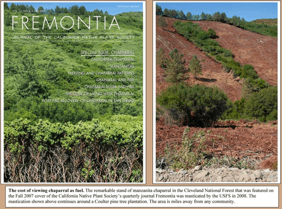
Their solution? To double down on what they’ve always done – clear 250,000 acres of native habitat per year (20 million acres total targeted) through grinding, burning, and herbicides in their proposed Vegetation Treatment Program (VTP).* Even though the state admits that this approach will fail to protect lives and property during the most devastating wildfires, it nonetheless remains California’s priority solution to the wildfire problem.

Here is what the state admitted in response to our proposals to make communities fire safe:

“When high-wind conditions drive a large fire, such as when large embers travel long distances in advance of the fire, vegetation treatment would do little, if anything, to stop downwind advance of the fire front.”

In other words, the state is going to ignore the fires that cause the greatest loss of life and property. Instead, Cal Fire, the state fire agency, will only address 95% of the fires – the ones they can easily control under calm conditions.

This is absurd. Imagine if we designed buildings to withstand only 95th percentile earthquake movements, or what you would feel as a result of a magnitude 2.5.

The science is clear. Proper vegetation management around homes and directly around communities is an important part of reducing fire risk. But the wholesale destruction of the natural environment is not.

We need to follow the science. We need to protect communities from the fires that actually do the most damage. And we need to stop pretending we can control Nature by destroying hundreds of thousands of acres of native habitat through Cal Fire’s proposed Vegetation Treatment Program (VTP).

The California state government has shown a pattern of failure when it comes to protecting us.

State politicians say they agree that making communities fire safe is a priority, but Governor Newsom rejected $1 billion in funding to do so. Instead, he championed a $21 billion program to protect utility corporations from liability for the fires they cause. The state promotes it’s efforts to protect biodiversity, yet it is planning on clearing 250,000 acres/year of native habitat under the guise of fire protection.

The California state government needs to fulfill the main obligation it has to its citizens – protect them from harm.

What you can do:
Please sign this petition and forward it to family and friends.

Dear Governor Newsom,

We urge you to reject the California Board of Forestry’s and Cal Fire’s current approach to dealing with wildfire – clearing habitat as described in their recent final Environmental Impact Report (PEIR) for the Vegetation Treatment Program (VTP).

1. Reject Cal Fire’s refusal to protect us from the growing threat of extreme, wind-driven wildfires. Cal Fire’s approach wastes millions of tax-payer dollars and fails to protect communities most at risk.

2. Immediately develop and fund a comprehensive and effective program to reduce the flammability of our communities through retrofits, exterior sprinklers, etc., so that our communities can survive wind-driven firestorms. We can do it, but it will require objective leadership OUTSIDE the Cal Fire bureaucracy, a bureaucracy trapped by its own paradigm paralysis – they can’t think outside their own priorities. Assemblyman Wood’s bill (AB 38), passed last term, provided an opportunity to make communities fire safe, but you did not support funding the program. The funding needs to be reinstated.

3. Develop and promote the policies needed to:

a. form community fire safety teams that will develop evacuation plans for actual disasters that will occur (not the minor events that we have been able to control in the past),
b. create fire safety parks WITHIN threatened communities where people can go and remain safe during a wildfire
c. form community-based volunteer fire response teams of people who DO NOT evacuate, but stay to assist their disabled and/or trapped neighbors
d. STOP the *unsustainable practice* of placing people in harm’s way by allowing development in known fire corridors

Here is a complete list of recommendations.

ADDITIONAL DETAILS supporting this petition

*To see the VTP, you can go to this link:
https://bofdata.fire.ca.gov/projects-and-programs/calvtp/

In case you might think the title of our petition is hyperbole, here is the text from the VTP EIR:

“Expansion of CAL FIRE’s vegetation treatment activities to reach a total treatment acreage target of approximately 250,000 acres per year to contribute to the achievement of the 500,000 annual acres of treatment on non-federal lands…” Page ES-2

And…

“Using this method, 20.3 million acres within the 31 million-acre SRA were identified that may be appropriate for vegetation treatments as part of the CalVTP…”
Page ES-3

An added note:
87% of the destruction to communities in 2017-18 was caused by 6 wildfires (out of 16,000), all wind-driven. The VTP admits it doesn’t address those. Let that sink in for a bit.

Here is the Los Angeles Times’ editorial that repeats much of what we are saying in this petition:

Editorial: California will never control raging wildfires if it doesn’t stop building in high-risk areas
By The Times Editorial Board
Nov. 29, 2019

After three years of devastating and deadly wildfires, perhaps we should no longer be surprised by them.

It was shocking in 2017 when the Tubbs fire jumped the 101 Freeway and charred a suburban subdivision in Santa Rosa. It was unthinkable last year when Paradise residents had to run for their lives as the city was almost entirely destroyed by the Camp fire. And still people were caught off guard last month when the Saddleridge fire forced hundreds of residents in Sylmar and Porter Ranch to flee their homes in the middle of the night.

A terrifying pattern has been revealed. California’s wildfires are now regularly destroying subdivisions and established neighborhoods that once seemed at low risk from wildfires. There’s ample scientific data and research to explain why: Climate change amplifies natural variations in the weather, leading to more frequent and more destructive wildfires. Poorly maintained utility lines are setting blazes.

Despite that, we’re still building homes — more and more of them — in fire-prone areas. State and local leaders have been slow to adopt the housing, land-use and development reforms that would make California communities much safer in the coming years. Here are a few suggestions culled from experts that, if enacted soon, could deliver lasting security.

Harden homes

The devastation in Paradise, Santa Rosa, Ventura County and Malibu demonstrated that homes are not only casualties in the fires, but also the fuel that feeds and exacerbates the blazes. Wind-driven fires can blow embers over great distances. The embers lodge under eaves, get sucked into vents or broken windows and can ignite a house from the inside out, which creates more embers and more heat. The fire then spreads from house to house, sometimes leaving surrounding trees largely untouched. The first and most obvious step is to retrofit homes in high-risk areas to make them more resistant to fire. Researchers analyzed some 40,000 buildings exposed to wildfires between 2013 and 2018. They found that homes built to keep out embers and withstand extreme heat were much more likely to survive. Yet so far, the state has done little to require home hardening or to fund it.

The needed retrofits aren’t very expensive. Homeowners should cover their vents with fine wire mesh and enclose their eaves to prevent embers from getting inside the structure. Double-paned windows are less likely to shatter in high heat, and steel shutters can help too.

Properties also need regular inspections to make sure they are prepared for fire season. Are there gaps in roof tiles that might allow embers into the attic? Are the gutters full of dry leaves and twigs? Do the residents know to shut the doggie door when they evacuate?

Earlier this year, Assemblyman Jim Wood (D-Healdsburg) proposed creating a billion-dollar revolving loan fund to help homeowners pay for retrofits and to remove flammable vegetation near their homes. The funding was cut from the bill.

Next year, Gov. Gavin Newsom and state lawmakers should invest that $1 billion — or more — to help people in high-risk areas make their homes more fire resistant. But it’s not enough to have individual homeowners voluntarily harden their houses if neighboring properties are tinder boxes. Fire is contagious. The greatest protection comes when entire neighborhoods are hardened together and maintained together. Whatever legislation is passed should reflect that.

Buy out burned properties

Still, all the fire-resistant materials and hardening in the world can’t guarantee safety. During the 2017 Thomas fire in Ventura County, new houses built to the strictest fire codes still burned down. The houses were in a state-designated “very high fire hazard severity zone,” which means the area has the greatest probability of burning based on vegetation, topography and fire history. And when 80-mile-per-hour winds blow embers across a landscape that is already prone to burn, the fire can quickly overwhelm hardened homes.

State officials have to recognize that there are some homes and neighborhoods that shouldn’t be rebuilt. Or rebuilt again, since some communities have burned more than once. For decades, the Federal Emergency Management Agency has helped buy out properties destroyed by flood waters, in a bid to stop the expensive and sometimes deadly cycle of flood-rescue-and-rebuild in high-risk areas. In Texas, communities have used a combination of local bonds, drainage fees and federal dollars to buy out flood-prone houses.

Buyouts are considered one of the most cost-effective ways to prevent flood destruction. These are voluntary sales and the government pays fair market value. The homes are demolished and the property becomes open space. It’s pricey to buy up dozens of properties at a time, but it can be cheaper and more effective than developing new flood control infrastructure.

Yet there’s been little discussion in California of trying to use FEMA grants or other funds to make similar buyout offers in high fire-risk areas. It wouldn’t be possible to buy out every property owner in the very high fire hazard severity zones — there are an estimated 2.7 million Californians living there. Rather, a buyout program could target the areas at the very greatest risk, perhaps because the community was built without adequate evacuation routes, or because the neighborhood has been burned two or more times before.

Don’t build in high fire-risk areas. But if development must be approved, build exceptionally safe communities

The best way to prevent wildfire destruction and death is to stop building houses in the path of fire. Half of all buildings destroyed by wildfire in California over the last 30 years have been in developed areas next to wildlands.

So far, though, gentle suggestions that local governments should consider wildfire risk when approving development aren’t working, and neither is Newsom’s call to “deprioritize” development in high fire-risk areas. Land-use decisions are made by local elected officials and they’ve proven themselves unwilling to say no to dangerous sprawl development and equally unwilling to say yes to denser, urban infill housing construction that would be more sustainable. Just look at Los Angeles County, where the Board of Supervisors approved construction of a 19,000-home mini-city to be built at Tejon Ranch in a remote valley that has been deemed a high risk for wildfires.

California lawmakers need to push — even force — local elected officials to make more responsible development decisions.

Earlier this year, Sen. Hannah-Beth Jackson (D-Santa Barbara) introduced Senate Bill 182, which would prohibit cities and counties from approving new housing developments in high fire-risk areas unless the projects meet new “wildfire risk reduction standards.” Those would include siting the homes so they have natural fire breaks and are easier for firefighters to defend, building evacuation routes, and having an ongoing, funded program to inspect and maintain defensible space around homes.

The bill was held up amid concerns that it could allow anti-growth cities to use the presence of some high fire-risk areas within their borders as an excuse to shirk their responsibility to build enough housing in the non-fire-risk areas of the city. That should not be allowed.

Yes, California has a severe housing shortage that is making the state unaffordable and unlivable for too many people. But the state can’t keep counting on sprawl to solve the housing crisis. That only puts more people at risk in future wildfires, and it generates more greenhouse gases as residents commute from far-flung subdivisions. That hastens climate change, which, in turn, worsens wildfire conditions in California.

The entire history of the state’s effort to ignore the fires that cause all the damage can be found here:
http://www.californiachaparral.org/threatstochaparral/helpcalfireeir.html

Modeling: worst-case scenarios

OSU professor Beverly Law and her researchers have published another paper on a topic we’ve discussed before, such as here — that it would be better, carbon-wise, to preserve forests rather than harvest timber. This new paper builds on that theme

Carbon sequestration and biodiversity co-benefits of preserving forests in the western USA

Authors: Polly C. Buotte1, Beverly E. Law, William J. Ripple, Logan T. Berner

Abstract and conclusions below. The paper is behind a pay wall.

I noted in the abstract that the authors based their modeling on “two high-carbon emission scenario (RCP 8.5) climate models.” RCP 8.5 was the subject of a recent article in Forbes by Roger Pilke Jr., “It’s Time To Get Real About The Extreme Scenario Used To Generate Climate Porn,” in which he says RCP 8.5 is a “worst-case scenario” and that “it may not even be a plausible worst-case scenario, because it requires improbable changes to our global energy policies, such as a wholesale return to coal throughout the 21st century and the abandonment of natural gas and renewables.”

So I hope any discussion here the Buotte/Law article will focus on climate modeling and scenarios, rather than the proposal to preserve much of the west-side forests and reduce harvesting (though that certainly is a topic of interest).

Abstract:

Forest carbon sequestration via forest preservation can be a viable climate change mitigation strategy. Here we identify forests in the western conterminous United States with high potential carbon sequestration and low vulnerability to future drought and fire, as simulated using the Community Land Model and two high-carbon emission scenario (RCP 8.5) climate models. High-productivity, low-vulnerability forests have the potential to sequester up to 5,450 TgCO2 equivalent (1,485 Tg C) by 2099, which is up to 20% of the global mitigation potential previously identified for all temperate and boreal forests, or up to ~6 years of current regional fossil fuel emissions. Additionally, these forests currently have high above- and belowground carbon density, high tree species richness, and a high proportion of critical habitat for endangered vertebrate species, indicating a strong potential to support biodiversity into the future and promote ecosystem resilience to climate change. We stress that some forest lands have low carbon sequestration potential but high biodiversity, underscoring the need to consider multiple criteria when designing a land preservation portfolio. Our work demonstrates how process models and ecological criteria can be used to prioritize landscape preservation for mitigating greenhouse gas emissions and preserving biodiversity in a rapidly changing climate.

Conclusions:

If we are to avert our current trajectory towards massive global change, we need to make land stewardship a higher societal priority (Chan et al. 2016). Preserving temperate forests in the western US that have medium to high potential carbon sequestration and low future climate vulnerability could account for approximately eight years of regional fossil fuel emissions, or 27-32% of the global mitigation potential previously identified for temperate and boreal forests, while also promoting ecosystem resilience and the maintenance of biodiversity. Biodiversity metrics also need to be included when selecting preserves to ensure species-rich habitats that result from frequent disturbance regimes are not overlooked. The future impacts of climate change, and related pressures as human population exponentially expands, make it essential to evaluate conservation and management options on multi-decadal timescales, with the shared goals of mitigating committed CO2 emissions, reducing future emissions, and preserving plant and animal diversity to limit ecosystem transformation and permanent losses of species


The American Prairie Reserve: Private Ownership and Conservation Writ Very, Very Large


This NPR story has some of the same themes as other topics we’ve been discussing about private lands conservation. What I like about this story is that it puts a different twist on many of the topics we discuss with regard to US government lands.

A privately funded, nonprofit organization is creating a 3.2 million-acre wildlife sanctuary — American Prairie Reserve — in northeastern Montana, an area long known as cattle country.

But the reserve is facing fierce opposition from many locals because to build it, the organization is slowly purchasing ranches from willing sellers, phasing out the cows and replacing them with wild bison. Those private properties are then stitched together with vast tracts of neighboring public lands to create one giant, rewilded prairie. The organization has purchased close to 30 properties so far, but it needs at least 50 more….

But the project’s efforts have garnered a lot of positive attention from those living outside northeastern Montana because, once it’s complete, it will be the largest wildlife sanctuary in the Lower 48 states — about 5,000 square miles, nearly the size of the Serengeti National Park in Tanzania.


(1) What I missed in this article was an understanding of the concerns of the ranchers.  It’s odd that the article focused on the Bible when more pragmatic answers are likely out there. Here are a few of my guesses for rancher resistance.

  1. reintroduction of critters that eat animals they care for and depend on for their livelihood. (personal economics losses)
  2. losing social capital from their already small community (friends, fellow volunteers, neighbors to borrow or help with things).
  3. losing economic capital from their already small community (taxes, donations, etc.)

I’m quite curious as to what kind of convos are going on in these communities about those concerns.  Conceivably the new owners have a plan for being good neighbors, paying for eaten livestock and so on.  What makes a good wildland neighbor? If it’s important for rich people to be good neighbors, how about Uncle Sam?

(2)  Another interesting aside in the story was bringing up where the owners got the money.

Do college profs get to determine the “appropriate goodness” of other people? And why interview a professor from Stanford about a story in Montana?

Some see hypocrisy in this kind of money, including Rob Reich, director of the Center on Philanthropy and Civil Society at Stanford University.

“The structure of global capitalism, which they had a role upholding, is partly responsible for the degradation of the environment,” Reich says.

If we go back to federal lands, Uncle Sam got it by dispossessing Native Americans.  To circle back to the New Testament, seems like stone-casting (John 8:7) has become a national sport.  I don’t think that that’s a good thing.

I also thought it was interesting that Garrity questioned the idea that producers of resources carry more responsibility than users:

But Gerrity says the reserve can’t afford to be that picky because almost all of his donors, big and small, are driving the climate crisis.

“The person who puts the gas in their car, or uses the coal in their house to heat, or the person who gets on a nonessential jet trip to take a vacation or go to a wedding or something like that, is the person actually creating the business and encouraging the oil companies to keep on doing what they’re doing,” Gerrity says.

(3) The owners buy only from willing sellers, so is this just another western “making a living” transition, along with ski areas, population growth (in some places), gas wells, wind and solar farms,  and so on?

Practice of Science Friday: The Roles of Researchers and Extension-Like Science Experts

The main role for researchers in applied science is to provide papers and other information that people can use.  In my analogy, they produce information to be used by someone- they blow out information and can’t necessarily control where it lands or how, or if it is used.

The main role for what we might call Extension-like activities, Forest Service folks in State and Private (nurseries, pathology and entomology), and experts in the National Forests (from fish and wildlife bios to social scientists)  is to sift through piles of research provided by researchers and use that to advice landowners or others making decisions about forests.  They search out  information and try to make sense of all the different studies and approaches, in light of the needs of the people they work for.  For the lack of a better term, I’ll put them all into one category- SSME’s or science subject matter experts. They vacuum up information from a variety of sources, as opposed to producing it.

Their roles are equally important, and complementary.  You don’t have to have a Ph.D. in psychology to figure out, though, that there might be disagreements and tensions (turf battles) between people in these somewhat overlapping roles. In some federal organizations, it has led to frustration as practitioners sometimes want to find out things, but they are not allowed to do research (based on their funding) and whatever they want to test looks like research to someone, so they are told they can’t do it. Basically they are told that their questions are not important enough to be funded as research, but are too “researchy” for the practitioners to do. Like any other field of activity, overlapping roles works well when people see eye to eye- not so much when they don’t.

Both groups are trained in their field. Many in the SSME world have Ph.D.’s and most have master’s.  Many researchers also, through their own personalities, or with some encouragement from their institutions, also do this kind of extension-like work.  In the past, there has been a tendency for people funded to do research to look down on people doing extension-like activities.  In fact, some folks don’t even seem to know that they exist.

Here’s one story- in the mid 90’s I worked in Forest Service Research and Development and I was one of a team working on improving the linkages between science and management.  Here’s a link to a copy of the report from 1995- “Navigating into the Future: Rensselaerville Roundtable: Integrating Science and Policymaking.”

As hard as I tried – my experience showing that SSME’s were the critical people to getting the best science into management- SSME’s were basically invisible in this document (I did get two paragraphs, titled Technical Specialists, on page 9. It was all about how researchers and decision-makers needed to work together- guidelines  for improving the institutional coordination.   you will understand how perhaps the emphasis on researchers doing SSME work left a gaping hole in acknowledging support for “real” SSME’s.

I don’t know that this is general or my own experience. When I started with the Forest Service in the late 70’s, my expertise was supported to the tune of financial support for a post-doc at North Carolina State.  By the end of my career (when I was Planning Director) I was told that I could not be on government time, nor give a government affiliation in the program, to give a talk at an SAF meeting when the invitation came with travel. I don’t think it was all intentionally against the Forest Services being better at science, there was just a “shouldn’t travel” factor that rose and fell in importance randomly.  Of all the Chiefs, Jack Ward Thomas was the one who really cared about promoting that kind of expertise. I couldn’t find a link to his idea of promoting professionalism by leaving experts in place and able to increase their pay.

Next post: The Land Grant Model and the Key Role of Extension