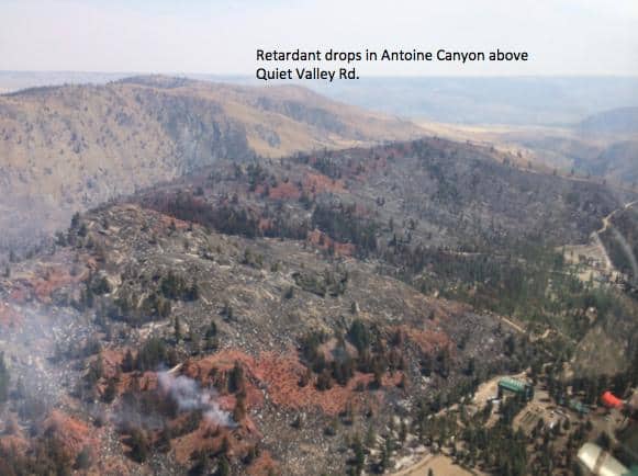
All’s quiet here at home, which gives me time to web surf. The Carlton Complex fire in central Washington is heating up again (temperatures > 100 with humidities in the teens). Inciweb posted this picture of aerial fire retardant lines.
Note the fire crossed the retardant lines, i.e., there is burned vegetation on both sides. Note that the fire didn’t burn the metal-roofed buildings and stopped where the private land had been cleared earlier of shrubs and trees.
During these Dog Days of Summer, I’ve been reading the Forest History Society’s interview of former Chief F. Dale Robertson. Dale was chief during the height of the spotted owl crisis, 1987-1993. The first region-wide injunction barring owl habitat logging issued in 1989, marking the beginning of the battle, with the Northwest Forest Plan ending the fight in 1994. All of the interview is worth skimming. I was struck with Dale’s recounting of his early days implementing the Taylor Grazing Act in Oklahoma where Dale was told to rein in ranchers who for generations had exercised unregulated, free access to federal forage:
This one guy, Joe Herbert, he was a tough nut. He was mean. He was defying us and he had his cattle out, so we had the U.S. marshals come and they arrested him, took him up to Muskogee to the U.S. Magistrate, and while he was in Muskogee we rounded up his cattle. There was even a shootout. Well, we had his cattle impounded. This was my predecessor, and he came up and shot the lock off the gate and let his cattle out. But anyway, it was tough.
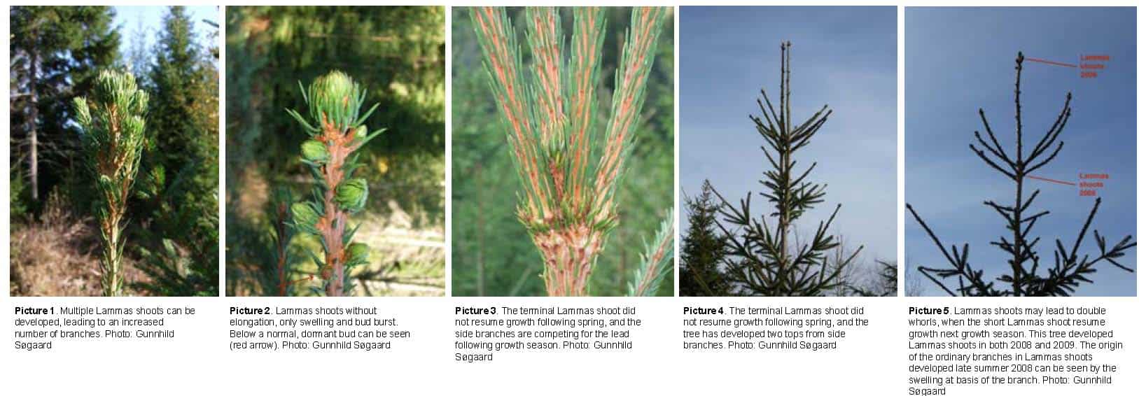
If you took tree or plant physiology, you may remember lammas shoots. According to Kozlowski here it’s because in England they occur around Lammas Day, the first of August. Also according to Kozlowski, they are called “Johannastriebe” in German and St. Martin’s shoots in France, after those saints feastdays.
Here is a recent (2011?) poster studying lammas shoots in Norway spruce. Because a variety of genetic groups were planted at different locations, they can parse out the genetic and environmental components.
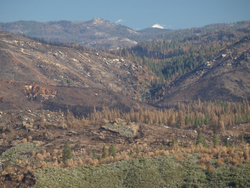
Google Maps now has updated photos that include the Rim Fire. Now, we can explore the whole of the burned areas to see all of the damages and realities of last year’s epic firestorm.
.
Here is where the fire started, ignited by an escaped illegal campfire. The bottom of this deep canyon has to be the worst place for a fire to start. It’s no wonder that crews stayed safe by backing off.
While there has been talk about the forests within Yosemite National Park, a public assessment has been impossible, in the National Forest, due to closures. Here is an example of the plantations I worked on, back in 2000, completed just a few years ago. What it looks like to me is that the 40 year old brushfields caused most of the mortality within the plantations. A wider look shows some plantations didn’t survive, burning moderately. When you give a wildfire a running start, nothing can stand in the way of it.
There is also a remarkable view of Sierra Pacific Industries’ partly-finished salvage logging. Zoom into this view and take a look at their latest work, including feller-bunchers. Comments?
Headwaters Economics produced two interactive maps that help users better understand the commercial activities on National Forests such as the timber economy–gross receipts, timber harvest sales, and timber cuts–at a variety of scales.
Gross Receipts from Commercial Activities allows users to view and download data on gross receipts from all commercial activities at the National Forest, State, and National Forest Region scale for the updated period Fiscal Year 1986 to 2013.
Timber Cut and Sold Reports allows users to view and download cut and sold data on timber volume, value, and price at the National Forest, State, and National Forest Region scale for the updated period Fiscal Year 1980 to 2013.
About 15 or so years ago, I attended a Leadership Academy for the Society of American Foresters for which Lynn Jungwirth was the keynote speaker on leadership. She was amazing and inspiring. I was thinking about the SAF meeting and thought I’d see if I could find a copy of her speech. While I couldn’t, I did find this interview from 2013, when she became a board member of Sustainable Northwest and so here’s a link. She is one of the founders of the community forestry movement in the US west, so this is relevant to our ongoing community forestry discussion.
SNW: What are some of your biggest accomplishments in the past year, policy or otherwise?
Lynn: Too many to list! We’ve made significant inroads in the state of California on biomass policy, especially as it relates to forest health. We’ve done a lot of community level work, as well as work with state partners. We have seriously affected the national cohesive wildland fire strategy to build capacity at the local level, so communities can adapt to fire and help the land around them adapt as well. On a local level, we have launched a prescribed fire strategy in Trinity County and trained local crews in understanding and conducting prescribed burns. This has been a great year for providing jobs to get young people experience in natural resources management.
SNW: What are your goals for the next three to five years?
Lynn: We are going to work on expanding the tools for community forestry in more communities throughout the West, especially by developing and improving the “hub and spoke” network. We will try to get the Forest Service involved on the local level and have them designate Trinity Forest as a community forest. We also receive significant Forest Service contracts each year and need to meet land planning goals as well.
SNW: What barriers are preventing you from achieving your goals?
Lynn: The biggest barrier is that there is no legal framework for local groups to work with federal land managers. We are doing “out of the box” work and therefore have to bend the system to do things differently. We must find another way because there is no standard policy to support our work. Many of the rules we deal with were written for a former institution, and there is no legal process or framework to do things differently. The Forest Service National Partnership Office has done a lot, but now we need the land management, procurement, and acquisition side to get involved as well for planning decisions and financial arrangements. Changes in tools and policies need to be prioritized.
SNW: If you could have 1 minute to address the President or Congress, what policies would you pitch?
2. Mr. President: We are ready for a rural agenda (AGO was ok?), but we need the people and land relationships figured out better. Livelihoods based on recreation don?t create the kind of relationship that we should have with natural resources. The practice of ?use and exploit? doesn?t work for both sides. We cannot continue to demean rural; rural lands are more than just vacation destinations. So far we either exploit it or have service jobs.
3. Some of the brightest, most courageous and energetic young people that want to live with and treat the land properly, have homes and families in our community. We must give them the tools to provide effective land management.
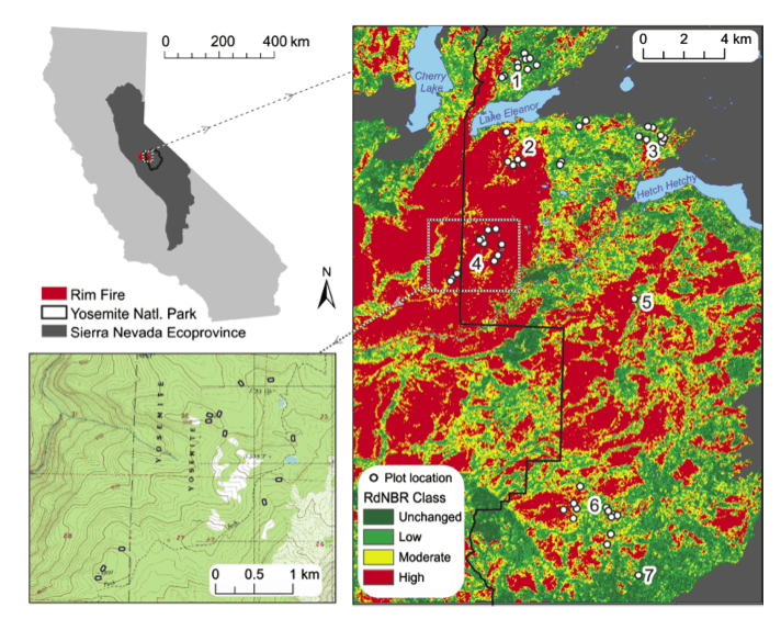
A new scientific study on the Rim Fire has just been published. “Severity of an uncharacteristically large wildfire, the Rim Fire, in forests with relatively restored frequent fire regimes” by Jamie Lydersen, Malcolm North and Brandon Collins is available here. What follows is the abstract, with some emphasis added.
Abstract
The 2013 Rim Fire, originating on Forest Service land, burned into old-growth forests within Yosemite National Park with relatively restored frequent-fire regimes (P2 predominantly low and moderate sever- ity burns within the last 35 years).
Forest structure and fuels data were collected in the field 3–4 years before the fire, providing a rare chance to use pre-existing plot data to analyze fire effects. We used regression tree and random forests analysis to examine the influence of forest structure, fuel, fire history, topographic and weather conditions on observed fire severity in the Rim Fire, as estimated from an initial fire severity assessment based on the relative differenced normalized burn ratio (RdNBR).
Plots that burned on days with strong plume activity experienced moderate- to high-severity fire effects regardless of forest conditions, fire history or topography. Fire severity was also highly negatively associated with elevation, with lower severity observed in plots over 1700 m.
Burning index (a composite index of fire weather), time since the last fire, and shrub cover had strong positive associations with fire severity. Plots that had experienced fire within the last 14 years burned mainly at low severity in the Rim Fire, while plots that exceeded that time since last fire tended to burn at moderate or high severity.
This effect of time since last fire was even more pronounced on days when the burning index was high. Our results suggest that wildfire burning under extreme weather conditions, as is often the case with fires that escape initial attack, can produce large areas of high-severity fire even in fuels-reduced forests with restored fire regimes.
Good piece on the Buck Rising sale in Oregon, one of the pilot sales designed under the “ecological forestry” pitched by Jerry Franklin and Norm Johnson. Having visited the sale and talked with the foresters who implemented the sale, My answer to the question posed by the article’s title is Yes. If timber management with a strong emphasis on creating and maintaining wildlife habitat won’t work (due to opposition from enviro groups), then nothing will. This is a battle that needs to be fought — it’s all or nothing.
This seems like a strange source for hearing about evolution in forest planning policy, but here is what the Region 6 regional forester is telling the world. It’s not something I remember serious discussion about when the 2012 Rule was developed, nor have I heard of it being done anywhere. Has anyone participated in something like this in forest planning? (I’ve added the bold type.)
Connoughton: Public policy for each national forest is set by law. The national forest plan follows the procedures of the National Environment Policy Act, the Endangered Species Act, and a few other pieces of legislation. The advantage of collaborating on a GIS platform is that people have data, tools, and maps that give them greater insight, and they can ask design questions. On the platform, you are in a spatial environment that allows you to display the problem, query one another’s ideas, and look at the logical outcome. This type of dialog becomes a mechanism for designing alternatives. Instead of forest service specialists putting together alternatives that are mandatory under the National Environmental Policy Act, they could collaboratively engage in setting public policy and ask design questions.
Boy, what an advance that is. Otherwise, we are drawing public policy from inside the government and the outcome does not capture people’s interest. Why not turn the ability to design public policy over to them. The foundation of policy is spatial. Its design is largely supported by sets of spatial information. This is very liberating to people who otherwise have had to depend on the government to create the forest plan.
Turning forest information over to people in a way they can understand is empowering. The responsibility of government is to be faithful and trusting to the people. The people then use tools for designing alternative solutions and public policies.