Why we need coordinated planning for habitat connectivity

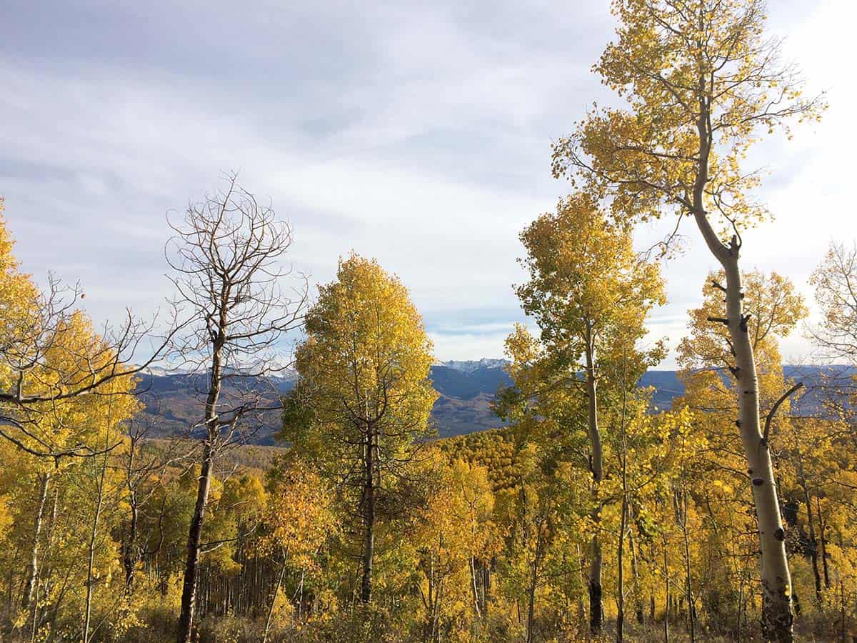
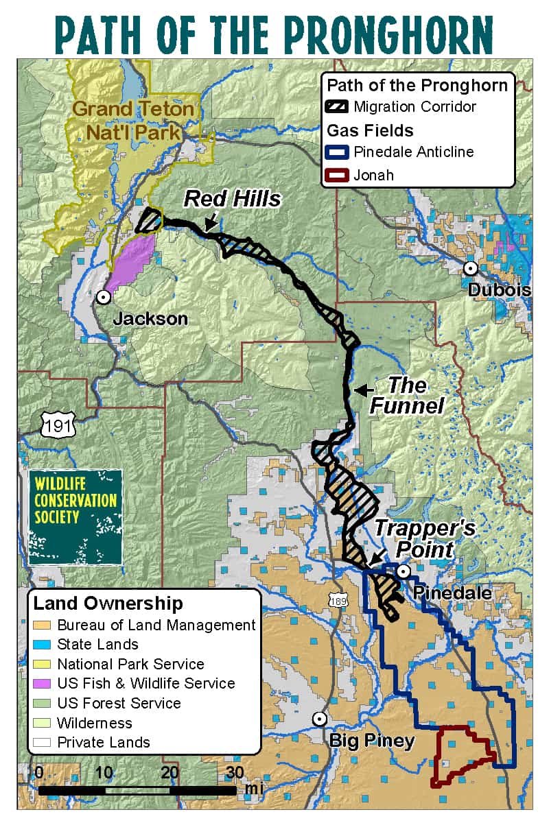
The Bridger-Teton National Forest amended its forest plan in 2008 to designate the portion of the “Path of the Pronghorn” migration corridor in Wyoming for special management to protect this historic 90-mile route with a northern terminus in Grand Teton National Park used for summer range.  It’s probably the most significant action taken by the Forest Service to plan for wildlife connectivity.

The BLM chose to not play along at the southern end where major oil and gas fields are found in the species’ winter range, and the migration route lacks recognition, and protection, through BLM lands along its southern reaches.  Now they have issued an EIS for oil and gas development there.  Ideally, the EIS will disclose the effects on pronghorn migration and on the national park (using the best available science), which could include exterminating this migration and its pronghorn herd.  But I wanted to comment on the planning aspect of this problem.  BLM blames the State of Wyoming:

“It would help us out if the [Wyoming] Game and Fish were to formally designate something in there,” said Caleb Hiner, who manages the BLM’s Pinedale Field Office.

The Forest Service didn’t wait for state action to protect national forest lands.  As an environmental activist said, “The BLM has all the authority it needs to protect what it wants to protect in a site-specific document,… The BLM could decide tomorrow that it doesn’t want to lease or develop any of the NPL.”

The 220-square-mile project has major economic potential, and could generate 950 jobs and produce somewhere in the range of 3 trillion cubic feet to 5 trillion cubic feet of natural gas, Hiner said. It would add up to 350 wells to the landscape annually for the next 10 years, a level of development that equals the number of wells permitted for drilling in the BLM’s entire Pinedale Field Office during 2017.

The argument by the proponent seems to be that they can figure out mitigation well-by-well, but at that point there is little opportunity to develop an effective strategy for pronghorn to navigate the system of wells, especially with no plan-level requirement to do so.

It is important for federal land managers be leaders in coordinating connectivity conservation planning, if for no other reason that that may be what is necessary to provide for viable populations of migrating species to continue to use federal lands.  The absence of a plan based on an overarching strategy for the full extent of the herd’s range could now be fatal to a ecological phenomenon that has been occurring, in part on national forest lands, for thousands of years.


Is a subdivision surrounded by national forest “reasonable?”


ANILCA provides: “Notwithstanding any other provision of law, and subject to such terms and conditions as the Secretary of Agriculture may prescribe, the Secretary shall provide such access to nonfederally owned land within the boundaries of the National Forest System as the Secretary deems adequate to secure to the owner the reasonable use and enjoyment thereof: Provided, That such owner comply with the rules and regulations applicable to ingress and egress to or from the National Forest System.” 16 U.S.C. § 3210(a)

“The U.S. Forest Service is currently considering approval of a new two-lane paved road across public lands north of Edwards to facilitate development of Berlaimont Estates — 19 new mansions, 2,000 vertical feet above town. The sprawling subdivision would be developed on a parcel that is completely surrounded by National Forest.

Unlike other nearby neighborhoods (e.g., Wildridge and Mountain Star), public land managers must approve a new road across lands owned by you and me to facilitate this proposal. To approve the new road, the Forest Service must deem Berlaimont Estates a “reasonable” land use.”

How does the White River National Forest determine what is a reasonable use?  Dose it matter what the surrounding use of the national forest is?  Does it matter if it creates bigger WUI problems?  When you buy a piece of land surrounded by public lands with no access is it reasonable to expect to build a subdivision?

These questions are intertwined (and sometimes conflated) with the question of whether the “regulations applicable to ingress and egress” (access) are reasonable.  Should the Forest Service be able to say that the proposed “32-foot wide, bermed, walled, plowed and paved thoroughfare switchbacking thousands of feet up a very visible hillside,” where “the walls necessary to support this road could be more than 1,000 feet long and as tall as 40 feet” is not reasonable?  The Forest Service has been upheld when it limits the kind of access to inholdings.  And by the way, “The 2002 Forest Plan designated this area Deer and Elk Winter Range and restricted winter use to minimize disturbance.”  It seems like a road with lots of use on it might be inconsistent with the forest plan.

It’s probably unfortunate that the local land use plan either allows a subdivision here or there isn’t any local planning.  It is Forest Service policy to get involved with that process, in part to help it deal with these hard questions.

Market solution to the WUI fire problem may be coming

It seems obvious to me that home insurance companies should be basing their rates on differences in risk of fire, and I’ve wondered why that hasn’t been happening more.  California seems to be the first place, but why should it stop there?

California’s insurance commissioner has warned that more and more insurers operating in the state are refusing to issue homeowners’ policies in areas most prone to wildfires.

Although many of the affected customers can still get coverage from other insurers, Jones noted that there has also been an increase in homeowners signing up for California’s insurer of last resort of fire; the FAIR Plan.

Jones said that the problem will only get worse as insurers label more homes as wildfire risks following the most recent series of wildfires that hit the state.

Others still disagree.  Something that doesn’t make obvious sense to me is that they seem to be looking at past fires more than the potential for future ones.

California national monuments pay off, and are intact so far, but not DRECP

Here’s some anecdotal evidence supporting the economic arguments for national monument designation.

Two years ago today, President Barack Obama created three new national monuments in the California desert: called Mojave Trails, Sand to Snow and Castle Mountains. Supporters held a community event to celebrate, noting that tourism to the area has increased significantly, as people come to see Joshua Tree National Park and then, go on to explore the new monuments.

Then there’s the Desert Renewable Energy Conservation Plan.

Under Zinke, the Bureau of Land Management recently filed a notice of intent to reopen the Desert Renewable Energy Conservation Plan, which sets aside land for conservation, recreation and energy development.  “Lands that were set aside for conservation may now be open to inappropriate uses like mining and renewable-energy development, when there was already a consensus on areas where those sorts of uses would be appropriate,”

Another example of Trumpling the interests of locals in favor of reducing the “burdens on all domestic energy development.”  Another case where the recreation industry (and others) will have to battle the resources of the energy industry (instead of working with the industry as they did in DRECP).  Who is your money on?

Review of collaborative restoration initiatives

The Forest Service funded a study (2 page summary here) of the Collaborative Forest Landscape Restoration Program and the Joint Chiefs Landscape Restoration Partnership.  Of note (to me any way):

Findings:  “Strong majorities said they had increased the pace and scale of restoration, improved ecological conditions, and reduced the threat of fire to communities.”  “61% said they had decreased litigation.”

Implications:  “The agencies should continue to make changes to their business model to ensure that their organizations are oriented towards the success of priority projects. The agencies should ensure quality leaders and staff capacity follow priority investments. The agencies also could refine proposal evaluation processes to better identify places likely to be successful, or those that are in need of support and capacity building.”

(I assume that the project “priorities” are a result of collaboration, too.)

Good Neighbor Authority

This isn’t something that has been discussed here, but in the last couple of days I’ve seen two stories that make it sound like the greatest thing since tab tops.

The Chequamegon-Nicolet National Forest may sell 123 million board feet of timber by the end of fiscal 2017, WJFW-TV reported. That would mark the fifth annual increase in a row for the forest, which is nearing its maximum yield.  Forest Supervisor Paul Strong said this year’s expected yield is “absolutely great news.” The forest’s management plan aims to sell 131 million board feet annually. Strong said the timber program has grown thanks to the National Forest Services’ increased authority under the 2014 U.S. Farm Bill and policies allowing organizations to remove small trees and keep the timber.  He also cited the federal Good Neighbor Authority policy, which has allowed the Wisconsin Department of Natural Resources to manage the sale of about 25 million board feet of timber in the national forest annually.

Idaho has been seeing success with using the “Good Neighbor Authority” it was granted under the 2014 federal Farm Bill to partner with the U.S. Forest Service and increase active management and timber harvests on national forests in the state – and it’s poised to ramp the program up.  Under GNA, the state Department of Lands can offer its expertise and help to the Forest Service where the service’s staffing is short, for everything from administering contracts for timber sales to jointly designing projects that are backed by local collaboratives.   Because Idaho had numerous forest collaboratives already in place – which bring together sportsmen, conservationists, industry, local government and more to help design projects to improve forests in their area – it was able to spring into action.  Schultz said the piece Idaho’s been able to include that earlier states didn’t is actual timber sales – which add the jobs and economic impact piece, along with fund the program itself.  Jonathan Oppenheimer, government relations director for the Idaho Conservation League, attended the Land Board meeting. “We’ve been involved in a lot of these collaboratives,” he said afterward. “We are cautiously supportive of the program. We see it as a good way to get work done.” He called GNA “a good tool, but one that we’re certainly watching closely.”

Here’s what the Forest Service says about it:

The Good Neighbor Authority allows the Forest Service to enter into cooperative agreements or contracts with States and Puerto Rico to allow the States to perform watershed restoration and forest management services on National Forest System (NFS) lands. Congress passed two laws expanding Good Neighbor Authority (GNA): the FY 2014 Appropriations Act and the 2014 Farm Bill. Each law contains slightly different versions.

  • The Farm Bill permanently authorizes the Good Neighbor Authority for both the Forest Service and the Bureau of Land Management (BLM) extending it to all 50 States and Puerto Rico. It excludes construction, reconstruction, repair, or restoration of paved or permanent roads or parking areas and construction, alteration, repair, or replacement of public buildings or works; as well as projects in wilderness areas, wilderness study areas, and lands where removal of vegetation is prohibited or restricted.

  • The Fiscal Year (FY) 2014 Appropriations Act included a five-year authorization for the use of GNA in all states with NFS lands to perform watershed restoration and protection services on NFS and BLM lands when similar and complementary services are performed by the state on adjacent state or private lands. Other than the adjacency requirement, there were no exclusions as to type or location of work.

Is there more here than meets the eye (good or bad)?  It does help with the financing.  Focusing on national forest lands that are “adjacent” to state or private lands seems like it would minimize controversy.  No mention of a collaboration requirement, but that seems to figure into it somehow.  If this is working so well, does the FS need more legislation?

When the locals pay for national forest fuel reduction …

Everybody wins?

“So were Flagstaff officials prescient when they proposed what, at the time, was one of the first municipal partnerships with a national forest to have lands outside city boundaries thinned at city expense?”

“Hindsight is 20-20, but it sure looks that way to us. Armed with a $10 million budget, the Forest Service immediately went to work on an environmental study that mapped the most fireprone timber stands as well as nests of endangered Mexican spotted owls.  Steep slopes most prone to erosion were pegged for less-harmful cable logging, and some stands of old-growth ponderosas were declared off limits. Using collaborative tactics learned from 4FRI, the draft EIS containing a thinning plan was ready in near-record time and drew no lawsuits that would cause delay.”

Could that be because there’s no revenue or profit motive driving more destructive logging practices?

Forest plans and “valid existing rights”

This is about forest plan litigation – sort of.  The Michigan Wilderness Act included a provision protecting “valid existing rights.”  A series of forest plan amendments by the Ottawa National Forest imposed restrictions on motor boat use on a lake that was mostly within a wilderness area but partly touching private land.  A 2007 Forest Order, subjected violators of Amendment No. 5 to criminal liability.   An earlier case concluded that Michigan riparian water rights allowed for “reasonable use” of the lake’s surface water, and that, “the motorboat restrictions interfered with Thrall’s ‘valid existing right’ to use gas motor boats on Crooked Lake’ and thus fell outside the Forest Service’s regulatory authority.”

The question in the current case was whether purchasers of lakefront property in 2010 also had “valid existing rights” to unrestricted motorboat use.  After sorting out the timing questions in favor of the private owners in this case, the Sixth Circuit court revisited the nature of riparian rights, holding that the Forest Service could only prohibit unreasonable uses:

“But the Forest Service has not shown that it would be unreasonable under Michigan law to travel on 95% of the lake above a low-wake-zone speed. If you think otherwise, try being at one end of a three-mile lake with a five-mile-an-hour speed limit as an unexpected storm sets in.”

(Evidently what’s reasonable in Michigan is different from what’s reasonable in wilderness.)


“I understand firefighter safety, but you have to put people on the fire.”


This from a resident near the Lolo Peak Fire – a fire that had recently killed one firefighter.  He added, “I’m tired of the smoke and I’m tired of the fire. I think there needs to be more accountability.”

I’m appalled by the sense of entitlement to protection of private property that this statement reveals, which I think helps illustrate the point I’ve been trying to make about who should pay to protect homes near national forests.  Sometimes that payment is measured in lives lost.

Utah counties make plans for federal lands

Sagebrush Rebellion light?

The state required counties to make these plans, which by itself should be a good thing (especially where there has historically been anti-planning sentiment). “This helps us to work with our federal partners to ensure Summit County’s interests are part of the conversation on how federal lands are managed,” said Sean Lewis, a Summit County planner and project manager for the drafting of the plan.  “This provides a template for us to work together with our Forest Service managers,” (Summit County Council member) Carson said. “We want to be partners with them. We don’t want to take stuff over from them and I am confident we will have a lot in common.”  This makes sense.

However, Summit County is a recreational drive from Utah’s urban centers, and we should expect other more isolated counties, with encouragement from anti-federalists, to want to use these plans to impose local control when federal land planning occurs there.  The article refers to the BLM requirement for a “consistency review” of local plans, but the 10th Circuit (New Mexico ex rel. Richardson v. BLM) held that, “A meaningful opportunity to comment is all the regulation requires.”  Nevada was similarly unsuccessful in using this provision to challenge federal planning for sage grouse (Western Exploration v. USDI).

The Forest Service Planning Rule also has requirements to “coordinate” national forest planning with local planning, which some would like to view as a consistency requirement.  But the Planning Rule also says, “The Forest Service retains decisionmaking authority and responsibility for all decisions throughout the process.”  The bottom line is that states have no authority over federal land management.