Another kind of access challenge

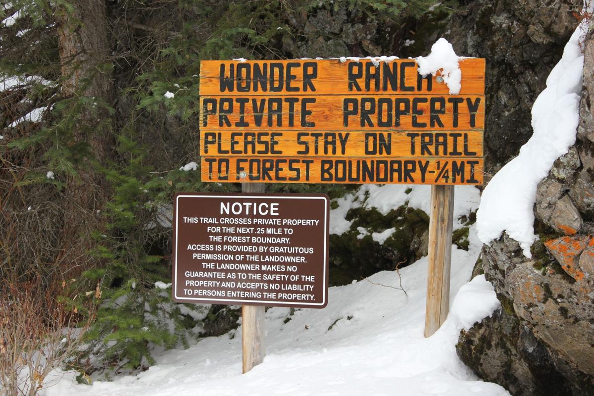
Sometimes the threat to national forest access results from undeveloped private land adjacent to a national forest becoming a subdivision, and here’s an example of that.

In a recent development (described on a subscription-only site) an Aug. 28 hearing has been set in a lawsuit filed by developer Easter Mountain Ranch LLC (EMR) against Cochise County, Arizona.  The county board had denied approval of a tentative subdivision plat for J6 Ranch, a 278-home gated community planned for the northern foothills of the Whetstone Mountains.  The land to be subdivided abuts the Coronado National Forest.  The issue in the case boils down to a requirement by the county for the developer to “provide multi-purpose (vehicle, pedestrian, equestrian, etc.) legal access to federal lands.”  The proposed subdivision would provide a road that dead-ends at the boundary of the national forest where roads are not allowed.

While the lawsuit about whether the developer met this requirement may hinge on the meaning of “access to,” the question I have is what is the Forest Service position and what has their involvement been.  They are not mentioned here.  It seems likely that the county position was an effort to coordinate with the Forest Service, and what exactly that meant should have been on the table for all parties to understand.  But where was the Forest Service?  (There’s nothing on the EMR or J6 Ranch on the Coronado website.)

Then I wonder about what kind of public access will be allowed through a “gated community.”

Personnel, politics and public access to public lands


Yes, it looks like Forest Service employees should be concerned about how Trump might affect their careers.  Here’s an example about offending private landowners who block access to national forests.  (And, without any facts beyond earlier stories, I’ll suggest that you not think of these as long-term rural residents, but more likely some recent, possibly seasonal transplants, with money and political connections.)

Here’s one version of the story from a private property rights promoter:

Such cooperation, however, changed under the Obama administration as the Forest Service took a more strident approach in asserting claims to “traditional public access” routes. The dramatic change is reflected in a posting by Yellowstone District Ranger Alex Sienkiewicz who publicly advocated “NEVER ask permission to access the National Forest Service through a traditional route shown on our maps EVEN if that route crosses private land. NEVER ASK PERMISSION; NEVER SIGN IN. … By asking permission, one undermines public access rights and plays into their lawyers’ trap of establishing a history of permissive access.”

According to Sienkiewicz and access advocates, traditional public access is sufficient to establish a legal right, known as a prescriptive easement, to cross private property. Centuries of legal practice, however, have required that individuals or agencies wanting to establish prescriptive easements must prove that access was continuous, open, notorious, and hostile to the owner. In other words, the access must be without expressed permission by the landowner, a burden of proof that has been difficult, to say the least.

This doesn’t sound like the complete story.  The federal government does try to protect its existing legal interests, and that includes historic access that may not have been formalized, which it tries to negotiate.  I doubt if it often pursues litigation, but does sometimes end up in court to defend public access, as in this case involving access to the Lee Metcalf Wilderness on the Indian Creek trail, cited by the author of the op-ed above as a good example of negotiation (at least until it apparently went bad).  The Forest Service met its “difficult” burden of proof in this case.  There is a risk that asking permission now could undo the historic rights that already exist, but I don’t think it’s large, and I am a little skeptical that the Forest Service would “post” statements like that above except in cases where a particular landowner had made it clear that they were declaring war on public access, such as in this example.

Here’s another version of the same story from a recreation outfitter:

Recently, the U.S. Forest Service removed District Ranger Alex Sienkiewicz from his position in the Yellowstone Ranger District pending an internal investigation into his efforts to defend historical Forest Service trails and easements along the Crazy Mountains.

When legal access to public land does exist, I believe Montanans fully expect the Forest Service to defend and maintain that access for Montanans. As with so many of these issues involving political pressure on public agencies, a look behind the curtain reveals a very troubling story. According to media reports, U.S. Sen. Steve Daines, and Congressman Pete Sessions from Houston, Texas, both contacted Agricultural Secretary Sonny Perdue regarding Sienkiewicz’s efforts to protect legal, established accesses to landlocked public lands. According to Mary Erickson, forest supervisor, “the reassignment was made after allegations from an assortment of landowners in the Big Timber area were raised to the level of the Secretary of Agriculture, Sonny Perdue, and Sen. Steve Daines.“

Here’s the background on the Crazy Mountains access.

Blocking and posting no trespassing signs at the head of Trail 115/136 prompted Yellowstone District ranger Alex Sienkiewicz to organize a trail clearing and marking trip this past summer. Prior to that the agency traded letters with the Langhuses’ Livingston attorney, Joe Swindlehurst, who has denied there is an old forest trail at that location.

It’s not a stretch to see this as politicians ordering a personnel move to keep public lands from public hands.  Dangerous on both counts.


Should the Forest Service intervene on the side of environmental groups?

“Public interest groups filed a lawsuit Thursday, Sept. 15, challenging the city of Highland’s approval of the high-density Harmony development. The development sits at the confluence of Mill Creek and the Santa Ana River and is directly adjacent to San Bernardino National Forest lands and will bring more than 3,600 houses to 1,657 acres of land acquired by Orange County Flood Control in the Seven Oaks Dam project that are currently home to numerous endangered species, rare habitats, wetlands and crucial wildlife connectivity corridors, according to the suit.”

“The lawsuit was brought by the Center for Biological Diversity, San Bernardino Valley Audubon Society and the Greenspot Residents Association, who are represented by the law firm Shute, Mihaly and Weinberger. It argues the city of Highland’s City Council’s August approval of the project violates the California Environmental Quality Act.”

It sounds like potentially illegal local government actions could adversely affect national forest resources.  Shouldn’t the Forest Service be trying to protect those resources?  (Not to mention what this would add to fire management costs.)

http://www.highlandnews.net/news/political/lawsuit-challenges-high-density-harmony-housing-development/article_f36e5c3e-7cfd-11e6-845e-2bf853763e42.html

Sage grouse plans are out

Here are national and state perspectives.


The proposals to amend federal BLM and Forest Service plans to protect sage grouse have been released. I haven’t read the new plan components but I have followed the process since I was peripherally involved before I retired from the FS, and I was also more heavily involved in developing similar strategies for bull trout, lynx and grizzly bears. This is the way conservation planning on federal lands should be done – but BEFORE it gets to the point of possible listing and this kind of crisis management.


It would be nice to see this happening now in the forest plan revision process for species of conservation concern (for which a regional forester has found “substantial concern about a species’ capability to persist over the long-term in the plan area”). Instead of consistent conservation strategies being developed (based on ecosystem and/or species-specific plan components) we see species like wolverine, which recently barely (and maybe temporarily) dodged listing, not even being identified as a species of conservation concern in the Idaho and Montana plans that are being revised.   There doesn’t seem to be a learning process here.


But the states are worse. They’ve had jurisdiction over sage grouse for the last century or two, and we’ve seen what results. It’s pretty laughable for them to now say the feds should follow state plans for sage grouse.


This is just flat out wrong,” Rep. Rob Bishop (R-Utah), the chairman of the House Natural Resources Committee, said of the plan. “If the Administration really cares about the bird they will adopt the state plans as they originally said they would. The state plans work. This proposal is only about controlling land, not saving the bird.”


Are the states trying to save the bird, or do they just see this as another opportunity to exert their control on federal lands?


Update From the Yosemite “Laboratory”

Here is a stitched-together panorama from the Foresta area of Yosemite National Park. I’ll have to pair it up with my historical version, one of these days. Restoration processes seem to be minimal, as re-burns continue to ravage the landscape, killing more old growth forests and eliminating more seed sources. Even the brush is dying off, due to a lack of organic matter in some of those granitic soils. With the 200-400 year old trees gone, we have to remember that these stand replacement fires, in this elevational band of the Sierra Nevada, weren’t very common before the 1800’s.

Foresta-panorama-crop-webYes, it IS important that we learn our lessons from the “Whatever Happens” management style of the Park Service. Indeed, we should really be looking closely at the 40,000+ acres of old growth mortality from the Rim Fire, too! Re-burns could start impacting the Rim Fire area, beginning this fire season.

Yosemite Visit

I recently spent three days in the Yosemite National Park area, shooting each day, in different locations. Yes, I did find a marvelous group of dispersed camping sites (free!) within the Rim Fire perimeter. Of course, they were there before the fire but, those spots still look great. Yes, there are also patches of high-intensity burn along Hardin Flat Road (the old highway) that have been salvage logged, too.

One of the places I went to, inside the park, was a large patch of high-intensity burn, all around Hodgdon Meadow. The campground wasn’t really impacted much by the fire. All around the fringe of the large meadow were green and healthy trees. They should be a good source of seeds, and it looks like most sugar pines had an excellent “cone year”. The problem will be the inevitable re-burns, with heavy fuels from trees like these:

OLYMPUS DIGITAL CAMERA

Yes, there are some tufts of green up there but, will the trees be able to fight off drought and bugs, with damaged cambium? Probably not. Yosemite has become a giant incubation “Motherland” for bark beetles, who don’t stay inside the lines on the map. However, I would recommend Hodgdon Meadow Campground (right near the Highway 120 Entrance Station) for your visit to Yosemite. There is something very primitive to camping under such giant trees (non-Sequoias).

Speaking of Giant Sequoias, I dropped into the Tuolumne Grove, to see how the Rim Fire impacted the area. I knew that firefighters had set up sprinklers, and I could tell by looking at the Google Maps view that there wasn’t much intensity there. This area (pictured below) was about as scorched as much as I could find, along the trails. Certainly, nothing to worry about. I’ll bet there is more insect mortality in the area than fire mortality. I’m sure that some will say they wished it had burned a little more intensely. Most of the grove didn’t burn nearly as well as in this picture.

P9204060_tonemapped-web

I went to Foresta, to view last year’s re-burn and the progress of “recovery” of the Yosemite side. Here are some views of that situation:

P9193965_tonemapped-web

Nine years after the re-burn, and 25 years after the original A-Rock Fire, this area remains desolate. Even brush is having a hard time growing, in soils with very little organic matter. The soils dry out and growth stops, during the hot summers.

P9193947_tonemapped-web

Looking westward, you can see last year’s re-burn, mostly on the Forest Service lands outside the Park. I worked on the original A-Rock salvage project, way back in 1991. I still have some Kodachrome slides from those days, up on that long ridge. The snags in this view probably survived the A-Rock Fire but not the Big Meadow Fire.

Yes, I did go into Yosemite Valley and found some uncrowded hiking along the Merced River.

P9214119_tonemapped-web

I did see some significant pine beetle patches, in Yosemite Valley. It seems like a “normal” level of bark beetles, considering the horrible drought, and all.

P9214227_tonemapped-web

There is a lot more to see over on my Facebook page www.facebook.com/LarryHarrellFotoware

New possible planning tool for the birds

The study analyzed 308 species of birds that live on lands managed by the Bureau of Land Management and U.S. Forest Service, the two largest public land managers in the western United States. Drawing on 1.7 million crowdsourced checklists submitted to the Cornell Lab’s eBird project, the researchers modeled where each species occurred in each week of the year across the nation. They then overlaid those results on a map of land management compiled by Jocelyn Aycrigg of the National Gap Analysis Program at the University of Idaho, a coauthor of the study. The map showed not only which lands were managed by the agencies, but what levels of formal biodiversity protection the lands had.

“It can get overwhelming thinking you need to do everything for every bird,” said Ken Rosenberg, a conservation scientist at the Cornell Lab and coauthor of the study. “This can really help hone in on what’s important for your piece of land—so you know what are the main species you can concentrate on.”

The study’s focus on so-called multiple-use lands (places that are neither set aside as wilderness nor completely open to development) highlights a strategic opportunity for conservation, Rosenberg said. It’s difficult to set aside new parcels of land, but adjusting priorities on existing lands can have a huge positive effect.

Read more at: http://phys.org/news/2015-01-bird-watchers-federal-agencies-priorities.html#jCp

This sounds like some good science the Forest Service should use to meet the viability requirements of the new planning rule where the Forest Service can not maintain a viable population of species in a plan area:

“… the responsible official shall:  (ii) Include plan components, including standards or guidelines, to maintain or restore ecological conditions within the plan area to contribute to maintaining a viable population of the species within its range. In providing such plan components, the responsible official shall coordinate to the extent practicable with other Federal, State, Tribal, and private land managers having management authority over lands relevant to that population. (36 CFR 219.(b)(2))


Local planning and forest planning

I think this article was an offshoot of the recent surge in discussion of transferring federal land to Montana (and other western states).  (A number of the articles linked in the sidebar are about that.)

This article ends up making an important point, but also shows how people can take that point and run the wrong way with it.  The important point is that a local land use plan is essential for having a discussion with the Forest Service about how a forest plan may affect local land use (and vice versa).  NFMA requires the the Forest Service planning process be “coordinated with the land and resource management planning processes of State and local governments and other Federal agencies.”  The 2012 planning rule requires the forest supervisor to “review the planning and land use policies” of other governments.

Here are the problems.  A local consultant states that, “federal land management must be consistent with local plans to the greatest extent possible.”  There is no such requirement; coordinating the process does not mean consistency with the results.  A county commissioner says, “more tangible issues, like whether a forest road gets maintained or how energy exploration and wilderness designations get decided, are what residents really care about.”  Local land use plans have no jurisdiction over federal lands and should not be addressing management activities that occur there.  Putting that kind of thing in a local plan does not bring it within the NFMA coordination requirement.  On the other hand, there may be need of coordinated planning of connected infrastructure like roads (or where subdivisions occur in relation to NFS management).

I’d like to think that whatever it takes to get local planning to occur is a good thing.  But I think that circulating the idea that local land use plans can govern federal land use will do more harm than good.


BP makes the FS look bad

An interesting story of “all lands” planning (or not).  BP has filed a lawsuit against a large residential development adjacent to its forested property, and also adjacent to a national forest.

“Along two miles of Cainhoy Road, the plantation’s eastern border is shared by the 250,000-acre Francis Marion National Forest, which is home to numerous threatened and endangered species as well as miles of hiking, biking, and canoeing trails. Perhaps the single most important forest management tool that BP and the Forest Service have is prescribed burning.”

“There is still time for everyone – the developers, the city, BP, the Forest Service, and the local community – to agree on an outcome that benefits the region for decades to come.”

The Francis Marion is revising its forest plan by the way.  Should it write off ecological integrity in this area?

It will be interesting to see what BP’s arguments are in court.  Perhaps the Forest Service will at least submit an amicus brief explaining how its national resources will be affected by this development.