I actually took this headline from an article about the status of the Salmon-Challis forest plan revision, but it pretty much describes planning in the Forest Service as a whole. With the exception of a batch of mostly Region 3 forests nearing the end of their planning journey, not much is happening. There are no signs of any new forests moving into the pipeline as the aforementioned revisions are completed.
The national status chart (source of this graphic – the last column shows the age of the plan) was updated April 1 (was there an inside joke here?). It doesn’t include where each forest is in the process, so I checked each of their planning web pages and produced the summary below (roughly in order of where they are from the end to the beginning).
Carson – Currently reviewing objections, final plan projected in spring 2022
Cibola – Currently reviewing objections, final plan projected in 2022
Santa Fe – Currently reviewing objections, final plan TBD
Nantahala-Pisgah – Currently reviewing objections, final plan TBD
Tonto – 60-day objection period began March 25, final plan TBD
Nez Perce-Clearwater – FEIS/draft ROD projected Fall 2021 (yes, that is the projection on the web page)
Ashley – FEIS/draft ROD projected October 2022
Grand Mesa Uncompahgre and Gunnison – FEIS/draft ROD projected late 2022 or early 2023
Gila – FEIS/draft ROD TBD
Lincoln – FEIS/draft ROD TBD
Sierra/Sequoia – FEIS/draft ROD TBD
Manti-La Sal – DEIS/draft plan TBD
Salmon-Challis – Notice of initiation 2018, NOI TBD
Malheur/Wallowa-Whitman/Umatilla – FEIS/draft ROD withdrawn in 2019, draft plan/NOI TBD
Black Hills – Currently in Assessment phase, NOI TBD
There is more information available in these charts, but they have not been updated for over a year (note the individual charts for each “service group,” the national “new planning model.” I used it to check out the forests that, at least at one time, appeared ready to start revision. From this list of forests that should have been “in revision” or “pre-revision” sometime this year, the only references to plan revision I found on any of the web pages have been quoted below. So there’s going to be a big gap in completed revisions.
In revision 2021: Shasta-Trinity, Mendocino, Six Rivers, Klamath, Rogue River-Siskiyou
In revision 2022: Cimarron Comanche, Bridger-Teton, Midewin, Humboldt-Toiyabe
Pre-revision in 2022: Fremont-Winema, Umpqua, Siuslaw, Willamette, Lolo, Caribou-Targhee, Curlew, NFs inTexas, NFs in Florida, Kistachie, Wayne, Allegheny
Bridger-Teton, – “unlikely that BTNF will receive funding to begin Forest Plan Revision until 2022.”
Humboldt-Toiyabe – “Work on Forest Plan revision has been suspended as resources and personnel are devoted to travel management, environmental analysis of grazing, fire and fuels management, and implementation of the American Recovery and Reinvestment Act.”
There is also this note from the Wayne explaining why they have stopped revising their forest plan.
Meanwhile the Bitterroot National Forest is doing some planning of another kind that is fairly unusual (but may be becoming more common), recently releasing a draft climbing management plan. Issues being addressed include the placing of permanent anchors (including in wilderness areas) and the need to buffer nesting raptors. However, “Work on a final NEPA-approved climbing plan will have to wait until the agency’s Washington office completes a set of national directives focused on climbing. Those could come as soon as this summer.“
In our recent discussion of the Nantahala-Pisgah forest plan revision, Sharon said, “Jon, that raises a question, how is sustained yield considered in the 2012 Rule and regulations?” Nicholas Holshauser did a pretty good job at answering there, but I want to provide a little more context because it’s a really good question with a complicated answer. I’ve highlighted terms to keep an eye on to help understand this.
Here are the relevant sections of NFMA:
1604(e)
In developing, maintaining, and revising plans for units of the National Forest System pursuant to this section, the Secretary shall assure that such plans—
(2) determine forest management systems, harvesting levels, and procedures in the light of all of the usesset forth in subsection (c)(1) of this section, the definition of the terms ‘‘multiple use’’ and ‘‘sustained yield’’ as provided in the Multiple-Use Sustained-Yield Act of 1960, and the availability of lands and their suitability for resource management.
1611(a)
The Secretary of Agriculture shall limit the sale of timber from each national forest to a quantity equal to or less than a quantity which can be removed from such forest annually in perpetuity on a sustained-yield basis: Provided, That, in order to meet overall multiple-use objectives, the Secretary may establish an allowable sale quantityfor any decade which departs from the projected long-term average sale quantity that would otherwise be established… Provided further, That any such planned departure must be consistent with the multiple-use management objectives of the land management plan. Plans for variations in the allowable sale quantity must be made with public participation as required by section 1604(d) of this title (procedures for plan revisions).
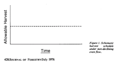
The law does not define sustained yield, and other language used here is not self-explanatory. That is most likely because it merely codifies the historic practice of the agency in its timber management planning, which was thoroughly understood by everyone at the time. Wilkinson and Anderson take this view in their contemporaneous examination of NFMA where they state: “The Forest Service has always placed a ceiling on each national forest’s annual timber sales from the suitable land base to insure a perpetual yield of timber” (p. 122), and, “the NFMA requires the Forest Service to follow NDEF policy (see below), with some exceptions.” That historical understanding was reflected in the 1982 planning regulations, and is still included in the Forest Service timber management planning handbook (§2409.13, Chapter 30).
Thus, sustained yield was always, and would be under NFMA, determined by identifying the land that would be used for timber production (suitable acres) and the volume per acre that would be yielded over time (including any reductions to accommodate other uses), and projecting the maximum harvest that could be achieved per decade over time without declining between any two decades (perpetually). Sustained yield thus required non-declining even flowof timber volume (NDEF), which was characterized as the “base sale schedule” for a forest plan. A declining flow would be referred to as a “departure” from this schedule and from non-declining flow. Because the parameters determining timber volume (acreage and competing uses) would change for each forest plan alternative, the sustained yield would also be different.
The 2012 Planning Rule states:
219.11(d)(6)
“The quantity of timber that may be sold from the national forest is limited to an amount equal to or less than that which can be removed from such forest annually in perpetuity on a sustained yield basis. This limit may be measured on a decadal basis. The plan may provide for departures from this limit as provided by the NFMA when departure would be consistent with the plan’s desired conditions and objectives. Exceptions for departure from this limit on the quantity sold may be made only after a public review and comment period of at least 90 days. The Chief must include in the Forest Service Directive System procedures for estimating the quantity of timber that can be removed annually in perpetuity on a sustained-yield basis, and exceptions, consistent with 16 U.S.C. 1611.
Planning Handbook now states
(§63.41)
“The Responsible Official shall determine of the sustained yield limit as the amount of timber that could be produced on all lands that may be suitablefor timber production, assuming all of these lands were managed to produce timber without considering other multiple uses or fiscal or organizational capability.
This new “sustained-yield limit” is obviously an entirely different beast. The acreage used includes lands that are not suitable for timber management, and the projected volume does not reflect other multiple-use decisions made in a forest plan (including such NFMA requirements as plant and animal diversity). The SYL does not vary by alternative, and would obviously be much higher than under existing forest plans. And since the replacements for ASQ (PTSQ and PWSQ) are supposed to be based on expected resource conflicts and financial constraints, volume targets based on these figures could never exceed that “capacity.”
The sustained yield “limit” is not actually a limit, and does not serve the purpose intended by NFMA of sustainable harvest volumes through its non-declining flow requirement. In fact, the Rule (despite requiring consistency with NFMA language) refers to “departures from this limit” instead of departures from NDEF. While the sustained yield “limit” may be non-declining, there is no determination that the actual harvest volume (PTSQ/PWSQ) could be sustained (unlike the former ASQ). Consequently, harvest levels (over time) have not been determined for the plan based on all multiple uses or based on NDEF, as required by NFMA. This seems especially problematic on the Nantahala-Pisgah, where they admit they calculated the sustained yield based on lands suitable for timber production that they claim will never be harvested; that’s an inherent contradiction. Until someone does the correct analysis, it’s hard to say how these changes affect this plan’s timber volume or whether there is a departure from NDEF that they should have disclosed to the public.
While there was some public involvement in developing the Planning Handbook (much less than for the 2012 Planning Rule), this radical break from tradition (and possibly from NFMA), was not made apparent to the public. It was only acknowledged in comments when the final Handbook was published. The Administrative Procedure Act requires effective public notice when an agency changes its procedures to this degree. There are therefore both substantive and procedural questions about this change in how timber management is being addressed in this and other forest plans.
It has always looked to me like this was a search for the “holy grail” of having their trees and logging them, too. More to the point, a national forest would have a much expanded land base relative to their expected timber volume targets, so they have a much easier job finding where to meet them.
Since Sharon has invoked my name twice recently, and not particularly correctly, with regard to the role of local interests in national forest management, I thought I would refocus that discussion on how this is supposed to work for local governments during forest planning using a current example that came along. It involves the participation (or lack thereof) by a county in New Mexico in the forest plan revision process for the Lincoln National Forest (where a final revised plan is expected soon).
The 2012 Planning Rule §219.4 requires “coordination with other public planning efforts.” It requires a review of “the planning and land use policies of … local governments, where relevant to the plan area,” which must be displayed in the EIS for the revised forest plan. It concludes, “(3) Nothing in this section should be read to indicate that the responsible official will seek to direct or control management of lands outside of the plan area, nor will the responsible official conform management to meet non-Forest Service objectives or policies.”
On March 1, the Eddy County Board of County Commissioners approved a resolution opposing the revised plan. They stated that, “it is clear that the USFS failed to review, consider and identify planning conflicts between Eddy County and the proposed plan.” Those alleged conflicts include:
would increase restrictions for cattle ranchers with reduced cattle grazing levels and increased financial burdens on cattle producers
“creates large areas restricted and potentially inaccessible to the County to fulfill its public health and safety duties”
“creates areas that will no longer allow proper wildlife management control increasing the danger to Eddy County citizen’s lives and property”
Eddy County’s resolution asked for a “coordination agreement” between the County and the Forest Service, “To establish roles and responsibilities for both parties, ensuring the citizens of Eddy County are still provided with the necessary services they depend on.”
I would agree that these are all arguably things that should be considered by the Forest Service, depending on what the specific plans or policies of the County say regarding these issues. (Unlike some earlier attempts at county “coordination,” they do not attempt to claim they have their own plans for national forest lands.) There is also nothing wrong with a “coordination agreement” to establish roles and responsibilities for “planning efforts,” but this is not something recognized by the Planning Rule, and is not a requirement. Moreover, the roles and responsibilities for national forest management are established in federal law and regulations; what local residents “depend on” does not dictate national forest management (as indicated by the highlighted language above from the Rule).
In this case, it appears that the County is also trying to close the barn door too late. According to the Forest, “In 2019 we reached out to Eddy County, inviting them to become a cooperating agency (in accordance with NEPA), which would have allowed them to be more deeply involved in the process of developing the plan, however we received no response from the county. Additionally, Eddy County did not provide any official comments on the forest plan to us.” (Failure to comment on the plan about the omissions they claim here would disqualify them from filing an objection and probably from suing.)
Reflecting both on Sam Evan’s piece and the associated comments, I’d like to pull out some additional observations of his for further discussion. This is the first of two posts.
First, I’d like to point out that I’m interested in posting thoughts of anyone who experienced the 2012 Rule process, either as a stakeholder or as an employee (this perhaps would be difficult even with anonymity for current employees, so perhaps a recent retiree). Sam was kind enough to offer this in response to a protracted campaign (years of harassment?) by me, but others are also welcome to submit.
Then, on to my thoughts.
TSW readers well know that I am not a fan of the abstraction “ecological integrity”. Nor NRV, for that matter. But how do people actually work through these abstract concepts in real (or at least planning) life?
So I was pleasantly surprised to find that Sam thinks (1)
First, and crucially, the Plan does provide detailed, well-supported desired conditions for each ecological community, or “ecozone.” Plan at 54–64. These reference conditions are grounded in the best available science and provide unifying direction for future management. Each set of “key ecosystem characteristics” describes characteristic species composition from the canopy to the forest floor, plus characteristic disturbance patterns and structure.
I would have been concerned about “how do we know what the landscape was like prior to the reduction in population/removal of Native Americans?” How can we possibly get Vegetation Desired Condition targets that are pre-Native American influence, or is our goal to emulate their activities? I also think about the American Chestnut, not coming back in the foreseeable future. Anyway, I was pleasantly surprised to see that they (the FS) apparently figured this out and the partner group agreed.
Sam also says “Still, much of the landscape is recovering well: pockets of old growth, disturbance-sensitive species, and backcountry areas large enough to allow for natural disturbance processes to resume.” That would be “natural disturbance processes subject to invasive diseases and insects, and climate change” so perhaps more clear would be “disturbance processes without local human intervention.”
(2) There is a tension between the existence of a “big blanket” suitable timber base, and the assumption that the forest will plan projects on all the acres in the suitable base. For example, Sam says “On average, therefore, 20% of harvests proposed under the new Plan are guaranteed to generate conflict” and what really happens on the landscape. Another example is “even-aged harvest is scheduled on a whopping 58% of the landscape.” See, I don’t interpret acres in the suitable timber base as being “scheduled”.. But that’s based on the model in my head of how this works (based on my own observations). To me, suitable acres are a big blanket. When FS folks decide where to put a sale, they use all kinds of different factors to decide where to put it… including where it will be less contentious. I don’t recall any forest (and for sure I don’t know them all) where everything in the suitable base was actually entered for timber management.
I don’t know what the suitable base was under the previous plan, but Sam says the forests were actually harvesting 750 acres per year. Now I don’t know if my numbers are right so please check but I added up the two forests’ acreages and got 1,044,000 million acres. At 750 acres per year, for a 30 year plan, 30 years or 22,500 acres and 2% of the Forests. At that rate, they would hit 2% rather than all 58% of the suitable.
(3) Which leads us to the issue of Post Plan Prioritization. Once you have the blanket (suitable base) where does the FS actually propose projects? It seems to me that Sam is arguing for more “Post Plan Project Prioritization” PPPP in the Plan itself. But there are other approaches that might work, like the less formalized “Zones of Agreement” approach that occur elsewhere. Actually, it sounds like it occurred here too, so the question is how formalized should it be? It seems like the other Zones of Agreement are more like a living process than a codified one. So this is a topic for discussion.. advantages and disadvantages or more or less codified PPPP?
(4) I also see both “Adaptive management “triggers” to gauge whether the Forests have the capacity to mitigate negative impacts before moving to stretch goals” and A “pacing” mechanism to ensure that high-consensus restoration occurs alongside scheduled harvest” as sub-plan level sideboards of a kind that are not exactly found in the 2012 Rule. The Rule says to monitor anyway, so why develop triggers in advance? Maybe those make more sense as an ongoing dialogue among partners and the Forest than a codification for likely to be thirty years?
But those are enough discussion points for now… next post will be on Sam’s more general observations about the 2012 Rule.
I’ve been wanting to hear from stakeholders involved with 2012 planning processes. Many thanks to Sam Evans for taking the time to share his experiences. I’m sure this will lead to a great discussion! In addition to the specifics of this plan, we can reflect on the overall context of the 2102 Rule, as Sam says “This is also a make-or-break moment for the planning rule. Ten years in, there are no more excuses. The rule is not in transition any more. What the rule means here, now, is what it really means.”
Better intentions; fewer commitments The Nantahala-Pisgah Plan Revision by Sam Evans
As the 2012 planning rule approaches its tenth birthday, another early-adopter is finally nearing the finish line. What does the Nantahala-Pisgah planning process tell us about whether we’re realizing the planning rule’s potential? Here’s a short history of a long process.
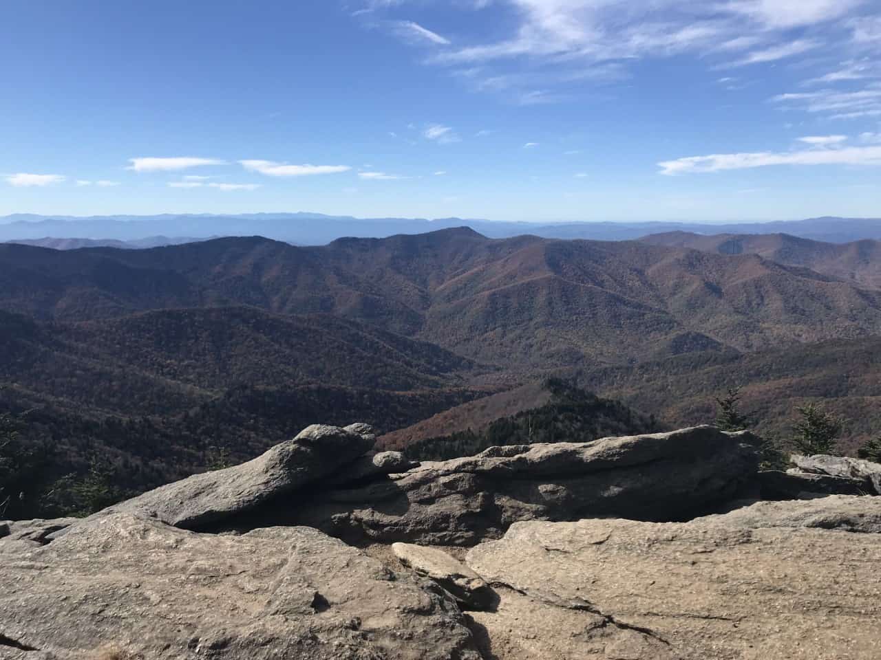
Black Mountains, Pisgah National Forest
Background
The contiguous Nantahala and Pisgah National Forests in western North Carolina are the heart of the Southern Appalachian mountains. Managed as a single administrative unit, these forests are the third most visited in the National Forest System, and the most visited without a ski resort. The forests here are marvelously diverse and bewilderingly complex. A short walk can take you, ecologically speaking, the entire length of the Appalachian Trail, which incidentally passes through the area on its way from Georgia to Maine.
Ecosystems repeat in small patches, with more variation and texture than stanzas in a Coltrane improvisation. A few acres here and there, riffing across the landscape. Dry, fire-adapted forests intermingle with moist Appalachian coves, which are among the most diverse ecosystems outside the tropics.
Those moist and productive cove forests also grow valuable sawtimber. And, like other productive forests with big trees, they have tempted mismanagement and abuse. The Forests have been through at least two periods of unsustainable logging, once before Forest Service acquisition, at the turn of the 20th century, and another after, in the 1980s. There is plenty of work needed to restore degraded forests’ composition, structure, and processes. Still, much of the landscape is recovering well: pockets of old growth, disturbance-sensitive species, and backcountry areas large enough to allow for natural disturbance processes to resume.
These remnant and recovering conservation values have been a source of conflict. Much more often than not, projects have created a zero-sum choice between harvest and environmental protection. The Forests’ first plan, adopted in 1987 at the height of the timber wars, was remanded by the Chief before the ink was dry in response to protests to end rampant clearcutting and protect old growth.
The 1994 amended plan fared little better. Without public support for timber production, the agency shifted its rationale, pitching rotational harvest as a way to balance age classes for the benefit of wildlife. But the timber program itself didn’t change. Old growth, rare habitats, and unroaded areas were still scheduled for rotational harvest, and the agency dutifully attempted to implement the plan at their expense.
Attempted, but without much success. While the 1994 plan amendment promised up to 3,200 acres of timber harvest annually, the agency has been able to produce just a fraction of this, with recent averages around 750 acres each year. Even at low levels of timber harvest, at least some conservation priority areas have been prescribed for even-aged harvest in most projects under the 1994 plan, and the ensuing conflicts have been a tremendous drag on efficiency, resulting in wasted time and dropped stands. In fact, the Nantahala & Pisgah NFs have the highest rates of project-level attrition of any forest in the ecoregion.
Changes between Project Proposal and Decision – Southern Appalachian NFs (2009–2019)
Fortunately, stakeholders have found better ways to work together. In some Districts, stakeholders built a shared, collaborative understanding of how timber harvest could be used to restore degraded systems. Capable agency leaders reflected their consensus at the project level and found new ways to fund important work that wasn’t always viable on its own. Although not uniformly, things got better.
This story, as unique as it felt to us locally, was happening in similar ways in different places across the country. Stakeholders were finding ways to transcend conflict. It was the right time to unveil the new planning rule, which sought to build on the insights earned in local laboratories: ecological restoration is a unifying goal, and consensus is the surest way to identify the highest priority restoration work.
The Nantahala-Pisgah Plan
Local stakeholders were so excited to put the planning rule into practice that they formed a planning collaborative in 2012, well before the agency kicked off its own process with a 2014 Assessment. While the process has not been without hiccups, the Nantahala Pisgah Forest Partnership has generated comments and recommendations with full consensus at each major step of the process including detailed recommendations on the Draft Plan in 2020. Full disclosure: I am proud to be a member of the Partnership, but I am speaking here only for myself.
The Partnership’s agreements cover every major issue from recreation to timber to recreation to wildlife habitat to wilderness. Without taking away from the importance of other issues, my focus here is on the ecological, social, and economic issues orbiting the Forests’ timber harvest program. The “where, how, and why” of logging were subjects of intense debate and compromise in the collaborative setting. The agency likewise spent most of its attention on goals that could be achieved through use of timber harvest.
The Partnership’s agreements were meant to be taken as a whole, and they recognized that management levels could increase considerably while also improving ecological outcomes if the Forest Service would commit to do the right kinds of things in the right places and provide safeguards for disturbance-sensitive ecological values.
The Final Plan, released in late January, purports to hit those targets:
Unlike the previous plan that framed activities in terms of outputs and traditional standards and guidelines, the revised plan developed desired conditions for each ecological community. By using ecological communities, projects will consider needs across a broader landscape, better enabling an increase in pace and scale of restoration.
Reader’s Guide at 5. The plan attributes these ostensible improvements to collaborative input, noting that collaborative stakeholders “created innovative approaches and processes” that “helped to create a more fully implementable plan.” FEIS App’x H at 12.
If only the plan content lived up to those intentions.
Does the Plan prioritize ecological restoration?
First, and crucially, the Plan does provide detailed, well-supported desired conditions for each ecological community, or “ecozone.” Plan at 54–64. These reference conditions are grounded in the best available science and provide unifying direction for future management. Each set of “key ecosystem characteristics” describes characteristic species composition from the canopy to the forest floor, plus characteristic disturbance patterns and structure. They explain, for example, that within moist, productive ecozones, disturbance is dominated by gap-phase dynamics, which produce a pattern of small gaps and fine-scale diversity. Dry forests, on the other hand, should have larger patches and relatively more young and open forest conditions. These key ecosystem characteristics, moreover, are essential to maintain and restore wildlife diversity: some species need small gaps within mature forests, while others need larger patches. Plan at 64; FEIS App’x D at 12. The Forest Service got the reference conditions absolutely right.
After painstakingly describing the key ecosystem characteristics for each ecozone, however, the Plan disclaims any requirement to move toward these desired conditions. The mantra is repeated throughout the planning documents: Projects may “locally deviate from the [natural range of variation]” in order to balance age classes at the forest-wide scale. Record of Decision (ROD) at 66. That’s because the Plan’s default tool is scheduled, even-aged harvest. Plan at 91, TIM-DC-06 (describing scheduled timber program). This type of harvest will occur even in ecozones where large-patch early seral habitat is uncommon under ecological reference conditions. While the Plan sets a modest target for creation of open forest conditions in fire-suppressed, dry forests, it anticipates that the overwhelming bulk of harvest will be even-aged and located in mesic systems. FEIS App’x D at 46-49 (modeling the anticipated timber sale program).
This program of work would not restore characteristic, fine-scale structural diversity in ecozones where it is needed. Indeed, the agency acknowledges that fine-scale disturbance processes aren’t currently happening at natural rates because the forests are in an even-aged condition due to past logging. ROD at 66. A mostly-even-aged harvest program would keep the forest on a treadmill that precludes reaching ecozone desired conditions for structure. The Plan would also allow the continued degradation of species composition caused by even-aged harvest where it is ecologically inappropriate. See FEIS at 3-160 (acknowledging that “less is known about the silvics and reestablishment” of characteristic species in cove ecozones).
The planning team does express an intention to do better work than the Plan’s bare minima. The Plan lists a few “management approaches” to address conditions where there is general support that timber harvest will improve species composition and structural diversity at relevant scales. Plan at 71-72. As recent projects demonstrate, however, intentions aren’t binding at the project level. Neither are management approaches. Targeted, site-specific restoration is an explicit goal only in the “Ecological Interest Area,” which covers 2.1% of the landscape. ROD at 56. Meanwhile, even-aged harvest is scheduled on a whopping 58% of the landscape.
Of the “suitable” management areas, moreover, over 100,000 acres (about 20%) are existing old growth, rare habitats, and wilderness inventory areas that have already been mapped by NGOs, the state, and the Forest Service, respectively. On average, therefore, 20% of harvests proposed under the new Plan are guaranteed to generate conflict—a depressing reminder of the 20% attrition rate that has dogged the old plan. When projects are developed in these areas, there are no standards or guidelines protecting their unique values. Whether to harvest old growth is left entirely to the District Ranger. State-delineated rare habitats can be harvested after “coordination” with no strings attached. Unroaded areas may be roaded without limitation. As in the old plan, conflict is the only backstop to prevent harm to these values.
The Forests argue that even-aged harvest counts as “structural restoration” anywhere it occurs, including areas with high conservation value, because it will restore young forest conditions at the landscape scale. But the Forests did not define restoration at the landscape scale; they correctly recognized that restoration means different things in different ecozones, which is why the Plan sets desired conditions at the ecozone scale. Yes, young forest is an important component of structural diversity, but the characteristic patch size and distribution of young forest is different in each ecological system, and those differences matter to the wildlife associated with each system. Ecological restoration in the Southern Appalachians simply cannot be reduced to “balancing age classes” at the landscape scale.
Why would the Forests set desired conditions for its ecozones but then forecast that it will ignore them in project after project? According to the agency, targeted, site-specific restoration actions to restore key ecosystem characteristics for ecological communities would be too expensive. Without scheduled harvest, “there would not be enough financial resources” to execute a self-sustaining timber sale program. ROD at 56. Timber receipts. Economic efficiency. The philosophy of the 1982 Rule lives on.
To sum up, the Forests argue they cannot restore characteristic species composition and structure at the desired levels with current budgets, so they conclude they must take actions that individually will not contribute to NRV, and when added together will be inconsistent with NRV. That is not how the planning rule works. The planning rule requires each planning unit to maintain and restore NRV, 36 C.F.R. §§ 219.8(a)(1); 219.19, and to ensure that its objectives are within its fiscal capability, id. § 219.1(g).
Failing to identify types and levels of restoration work that can be achieved with expected budgets isn’t just bad planning; it also creates a self-defeating cycle. Without clear price signals, agency higher-ups (much less Congressional appropriators) will not know how much funding is needed to truly restore our forests. By conflating ecological restoration with scheduled timber harvest, a local Forest may preserve some future flexibility to continue with a timber sale program even when budgets are low, but it undermines its own ability to seek and justify the budgets it needs to do the most important work.
This is not to say that there is no room for timber production on the Nantahala-Pisgah, or that the Forests must set trivially small objectives that do not meet economic or social needs. The Partnership offered consensus recommendations that would have allowed the Forest Service to grow its timber program while also meeting its ecological restoration obligations. Did any of that work make it into the Plan?
Does the Plan reflect collaborative input?
The Partnership reached consensus and provided detailed input at every major checkpoint of plan development, covering the full range of issues from land allocation to wilderness recommendation to plan components. Boiled down, our recommendations for vegetation management included:
Increased levels of timber harvest at current budget levels
paired with
Protections for steep slopes and streams, old growth, areas with high diversity, and rare habitats
“Tiered objectives” (Stretch goals) to allow the Forests to increase levels of timber harvest even further if additional resources are available
paired with
Adaptive management “triggers” to gauge whether the Forests have the capacity to mitigate negative impacts before moving to stretch goals
Scheduled timber production on a suitable base that excludes areas known to have high potential for conflict
paired with
Wilderness recommendations that would be supported for designation after meeting benchmarks for success in plan implementation
An unsuitable management area that allows for the use of all appropriate tools, including timber harvest and road construction, to accomplish ecological restoration based on site-specific needs
paired with
Backcountry management in which restoration would occur primarily by use of natural disturbance and prescribed fire
A high degree of flexibility to develop stand-level prescriptions
paired with
A “pacing” mechanism to ensure that high-consensus restoration occurs alongside scheduled harvest
In short, the Partnership asked the agency to increase harvest levels and improve ecological outcomes—to “do more, better work.” To succeed with current budgets, we knew that we needed to avoid unnecessary conflict. Each of the recommendations was therefore calibrated to proactively address tensions that would otherwise create project-level friction.
For example, all members supported levels of harvest that are beyond the Forest Service’s current capacity, provided that increasing harvest levels does not exacerbate the road maintenance backlog (a proxy for risk to water quality) and the spread of non-native invasive plants. So, we proposed “tiered objectives,” or stretch goals, which were accompanied by adaptive management triggers (e.g., reduction of the road maintenance backlog, treatments levels for invasive plants). When we can demonstrate that we can keep up with the work needed to mitigate negative impacts at Tier 1, then we know we are within our fiscal capability to stretch to Tier 2.
As another example, some members strongly felt that project-level flexibility was essential to meet restoration needs in viable timber sales, but other members were worried that commercial realities would lead to too much even-aged harvest in the wrong ecozones, like coves. These are inherently plan-level questions: how much is too much? Failing to answer those kinds of questions in the plan will create the conditions for sustained conflict at the project level. To avoid that, we proposed a pacing mechanism. We asked the Forest Service to track types of harvest and ensure that at least half of the total is in one of several priority treatment types—common conditions where timber harvest (including commercial harvest) can maintain or improve stand-level composition or function.
These were innovations we believed would not only solve local problems, but might also be useful for other forests with similar challenges. Indeed, some kind of pacing mechanism is essential to meet the goals of the 2012 rule. Ecological restoration does not have a cookie-cutter solution. It requires some measure of flexibility to do the right things at the project level, but it also requires some mechanism to ensure that we’re doing them in the right proportions in the right places in the longer term.
Unfortunately, the Forests rejected these carefully balanced recommendations. They agreed to increase timber harvest levels, but declined to include any pacing mechanism to ensure that the types and proportions of harvest would restore ecological integrity. They adopted tiered objectives, but they declined to adopt the triggers needed to determine when we are ready to move to the more ambitious targets. They emphasized scheduled timber harvest, but declined to limit it to areas without high potential for conflict. They created an ecological restoration management area but declined to put any substantial acreage in it, instead enlarging the suitable base.
Despite these choices, it’s hard to argue that the planning team has not been committed to public process. At stakeholders’ request, the DEIS alternatives were deliberately calibrated to keep stakeholders from retreating to their corners. During plan revision, planners attended dozens of meetings. Specialists were generous with their time and expertise. And the agency clearly expects the collaborative process to continue into implementation. Plan at 25.
Yet the Forest Service did not roll up its sleeves and actively engage in the process of developing collaborative solutions. Agency thinking happened in a black box, with progress revealed only during formal public comment periods. ID Team meetings were closed, and there was minimal dialogue or feedback. With a Plan that describes work far outside the zone of consent, it appears that consensus proposals were not understood or valued. As a result, it is hard to trust that the agency’s commitment to the collaborative process will result in implementation of collaborative outcomes. Indeed, if project-level discretion and collaboration were enough, we wouldn’t need a new plan.
Here’s how things look in hindsight: Dozens of professionals and volunteers spent eight years working to build consensus at the Forest Service’s request. We were asked to put aside past conflicts created by a parade of zero-sum projects and to imagine a different future. We were asked to be ambassadors to our respective communities. And we showed up. We stretched our comfort zones to the limit, and we handed the agency a roadmap for ecological and social sustainability. Meanwhile, the Forest Service was digging a moat around the plan it intended to finalize from the start—a plan that makes our work irrelevant.
The 2012 Rule after 10 Years
There you have it. Better intentions; fewer commitments.
I realize that some of you will read that as a good thing. Some will argue that increased agency discretion will result in bigger accomplishments. Others will note that a lack of protective standards will cause greater harm. Still others will hope that, despite a lack of clear plan direction to protect conservation values and restore key ecosystem characteristics, we will find a way forward anyhow. That the relationships, improved understanding, and good intentions formed during the past ten years will help us design successful projects in the next fifteen. (“The real plan is the friends we made along the way!”)
For my part, I cannot believe that the 2012 Rule was intended to fund years-long, expensive processes that don’t produce decisions to solve problems. If we’re simply hoping that we can reach the same compromises again later at the project level, why not reflect them in the Plan now? Why did we accumulate ten years’ worth of analysis and consensus-building only to defer the decisions to the project level, where we can analyze and contest them again and again? These questions, moreover, are bigger than any single plan revision: why should self-respecting stakeholders invest years in future collaborative processes if their collective input can be so dismissively rejected? In the interest of protecting both agency and stakeholder time investments in this planning process and encouraging similar investments in future planning processes, the Forest Service should make decisions now that will reflect consensus and improve efficiency during implementation.
If the Nantahala-Pisgah’s Revised Plan is any indication, we have a long way to go to realize the promise of the 2012 Rule. I continue to believe that the Rule’s innovations—ecological restoration and consensus-building—are the agency’s path to continued relevance, but the 2012 Rule will ultimately be judged by the projects (and, unfortunately, by the conflicts) that it produces. Based on our local experience, what is working for the Rule, and what are the challenges?
Identifying and ensuring progress toward restoration goals:It is possible to develop broadly supported reference conditions for ecological restoration in distinct ecological systems, even in highly altered eastern forests. There is good scientific information available, much of it developed by partners and agency professionals working together.It is harder to craft plan components that can make meaningful progress toward reference conditions with anticipated budgets. The problem is simple: under an ecological restoration paradigm, the highest-priority work is often the least economical. On the other hand, there is a real potential for increasing budgets in coming years. Although the planning rule’s fiscal capability requirement is important, it should not be a straitjacket forcing planners to choose between (a) trying to justify doing the wrong things because they can pay for themselves and (b) doing nothing at all.Surmounting this problem requires a willingness to innovate beyond the planning rule’s text. Tiered objectives and adaptive management triggers offer a platform to justify additional funding, incentivize partner contributions, and get more done. But doing more is not an end in itself. A pacing mechanism is essential to ensure that the easiest or most commercially viable work does not displace higher priority work or get ahead of mitigation needs. Both of these innovations can be incorporated into traditional plan components.
Increasing the pace and scale of ecological restoration also requires more thoughtful and efficient land allocations. The Forest Service must ensure that known conservation assets are not mapped into suitable management areas, where plan-level acreage and volume goals take priority over local values by default. Such allocations inevitably will result in continued project-level conflict and attrition. Conflict as a sideboard for conservation values can only “work” at low levels of harvest; it will not allow us to scale up without damaging ecological values and the public trust.
Supporting, participating in, and reflecting collaborative work:The Forest Service has learned a great deal about how to create opportunities for collaboration and to provide support to its stakeholders with information and resources. This was an important goal of the planning rule, and the Nantahala and Pisgah NFs have taken it seriously.The agency “black box,” however, remains a major obstacle to effective collaboration. When planners believe they know the right solution already, they are likely to shield the messy parts of the process from scrutiny. Collaboration works best, however, when agency staff are willing to work toward solutions as participants. The agency should communicate better about its own institutional needs and limitations to support consensus-building around new approaches that will work for partners and the agency alike.But it is essential that planners understand they need the public’s help to find the right answer, and they must be willing to reflect consensus in the plan itself—to share decision space. While some forests and districts have taken the plunge, there remain pockets of institutional resistance. Collaborative stakeholders will often ask for guardrails to ensure future actions stay within the zone of consent, and those guardrails can be at odds with agency preferences for greater discretion. Agency leaders must learn that setting limits during the planning process isn’t at odds with agency discretion but is instead an efficient way to exercise agency discretion. Ultimately, collaborative planning must offer stakeholders more than a request to trust its intentions. Trust requires accountability.
The Nantahala-Pisgah Plan is caught in the middle between what the agency is getting right and the lessons it has yet to learn. It’s optimistic but unfinished. Fortunately, there is still time to get it right. This plan is too important to give up on yet—both for the Nantahala-Pisgah and as a model for other forests that are trying to overcome histories of conflict.
This is also a make-or-break moment for the planning rule. Ten years in, there are no more excuses. The rule is not in transition any more. What the rule means here, now, is what it really means. Can the agency commit to work for better outcomes, build trust, and demonstrate its relevance to a public that is increasingly worried about the climate and biodiversity crises? Or will it teach the public that restoration is just another euphemism for business as usual? The next few months will tell.
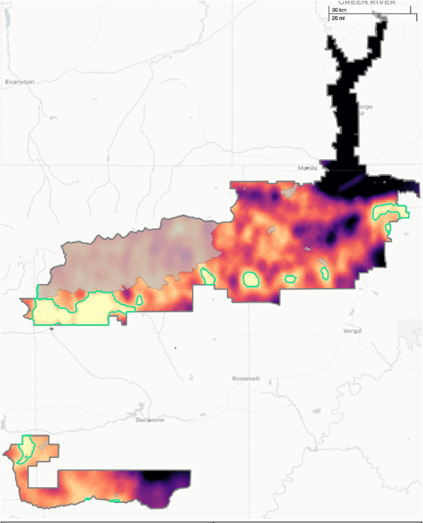
High Ecological Value Areas (yellow) – Ashley National Forest
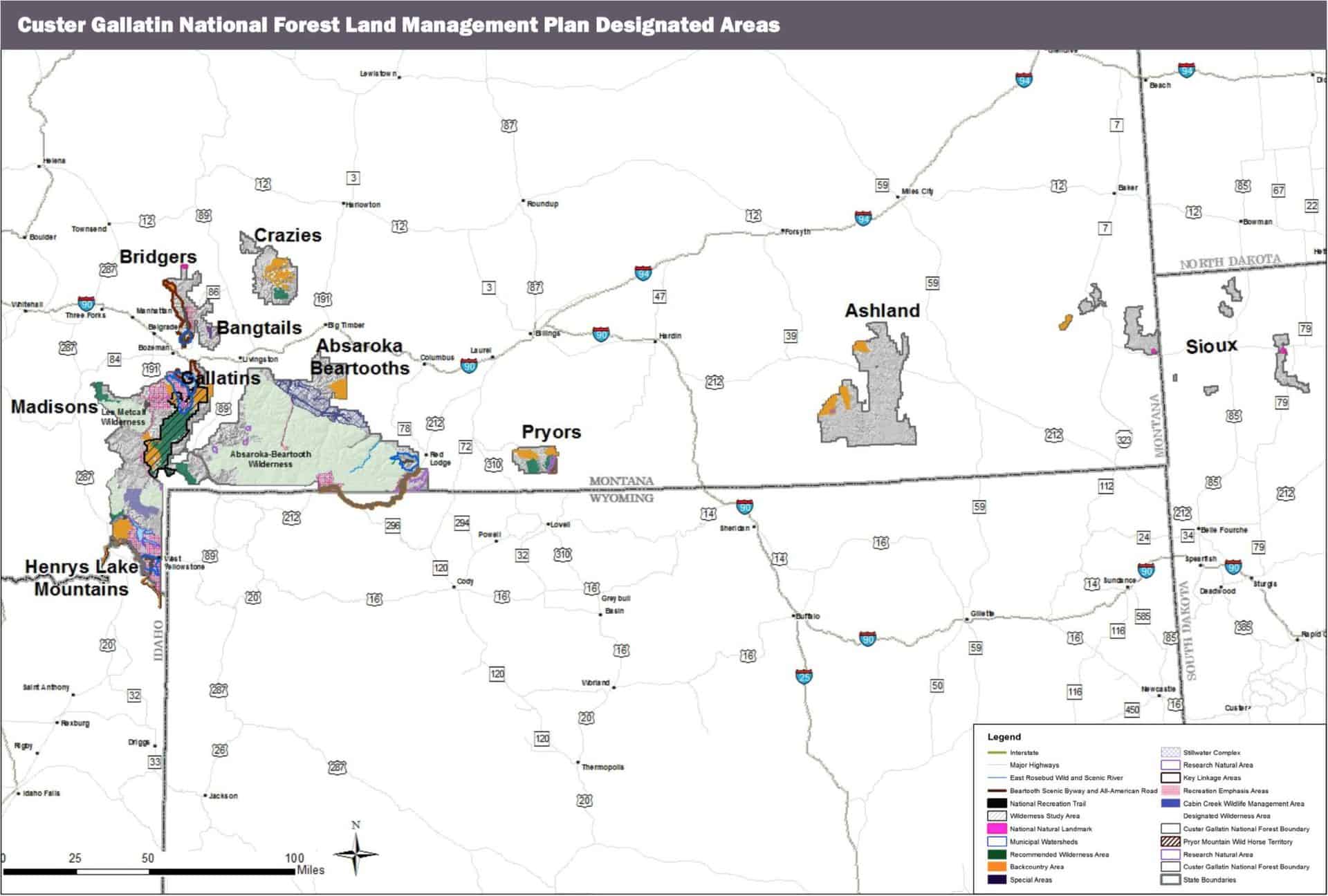
Sharon just posted the news that the Custer-Gallatin revised forest plan has been released. Here’s a few other bits and pieces of planning news.
Custer-Gallatin forest plan revision. Here is a counterpoint: “We have worked hard, jumped through all their hoops, hoping for a reasonable and sensible plan that will facilitate long-term viability of the forest’s biodiversity. One can also hope to see a Unicorn.” (Is this one of those who “never had any intent of collaborating on anything?”)
Nantahala-Pisgah forest plan revision. I was pretty sure there was a recent post on this, but I couldn’t find it. Here’s a counterpoint from the Southern Environmental Law Center: “There is a lot of consensus on what the forest service says they should be doing and where it should be doing it and if they would operate within that social license, then they could complete that level of timber harvest without creating any problems. They basically declined doing that.”
Sierra and Sequoia forest plan revisions. The Forest Service released their periodic update on the status of these revisions: “We have reviewed the more than 7,000 responses we received during the 2019 comment period and have been updating the final revised forest plans and EIS in response to comments received and considering recent large wildfires in the plan area. Release of the final revised forest plans and final EIS for the Sequoia and Sierra National Forests is anticipated later this year.”
Ashley forest plan revision. Conservation Science Partners has completed a report for The Pew Charitable Trusts that identifies the relative ecological value of lands outside of protected areas based on a collection of key spatial data sets, including climate resiliency and carbon sequestration. The comment period for the draft plan and EIS closes February 17. (The resulting map is shown above.)
Blue Mountains forest plan revision. The restarted process for the Malheur, Umatilla, and Wallowa-Whitman National Forests is moving again with the submission of new proposed “desired conditions” for the forests to the Blue Mountains Intergovernmental Council. The Forest Service formed the BIC, made up of county officials, tribal members and other stakeholders from the Blue Mountain region, after the agency’s proposed 2018 management plan revision fizzled in the face of intense public scrutiny. The Eastern Oregon Counties Association had listed eight main objections, including economics; access; management area designation; pace and scale of restoration; grazing; fire and salvage logging; coordination between agencies; and wildlife. Craig Trulock, Malheur National Forest supervisor, said he is not sure when the revision process would begin.
Wayne recreation amendment. The Wayne National Forest has adopted a Recreation Amendment to its Forest Plan which takes out direction from the Forest Plan and allows the Forest Supervisor to determine closure dates, allowing biking and horseback trail use to be extended based upon “weather and other factors.” (I’m in favor of this kind of seasonal criteria being forest plan guidelines due to different conditions year to year, but if there is no longer anything in the forest plan, the public won’t know what those factors are, or how they would be applied.)
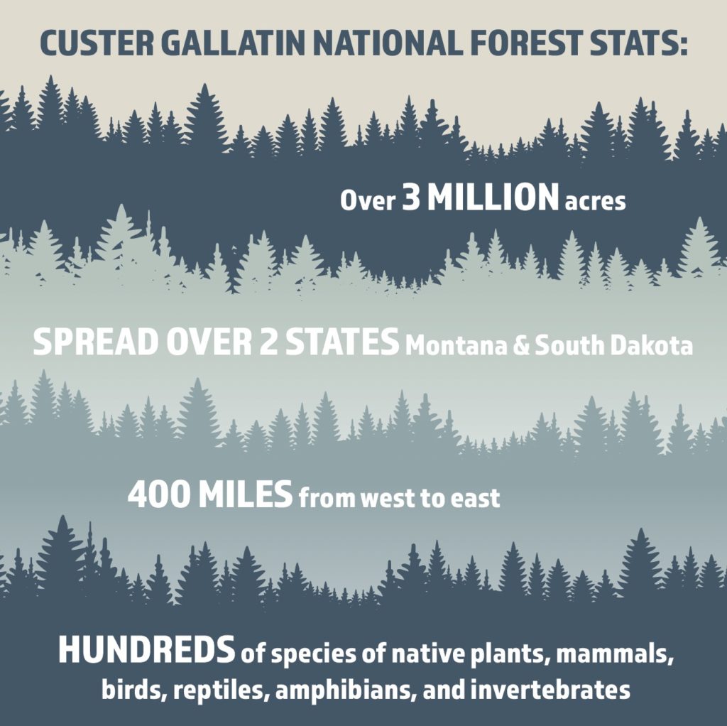
Custer Gallatin National Forest spans 400 miles east to west. GRAPHIC COURTESY OF CUSTER GALLATIN NATIONAL FOREST/USDA FOREST SERVICE
I may have missed it, but was there already a post on the Custer-Gallatin plan? This news story from Explore Big Sky talks about it, and about how collaboration on the plan worked. And it only took six years, which is good for a complex plan.
“In the first stages of this, we had a bunch of people involved in these meetings, who really honestly never had any intent of collaborating on anything,” said Big Sky resident Steve Johnson. “There were significant factions on both extreme ends of, you know, it’s my way or no way.”
Johnson has been involved in the process since early conversations about a decade ago. At a certain point, he said, it became clear that a collaborative agreement wasn’t going to happen.
In the interest of providing cohesive feedback to CGNF, Johnson and other individuals from the surrounding area formed the Gallatin Forest Partnership in 2016 and submitted the final Gallatin Forest Partnership Agreement to the forest service in 2018. Johnson said that agreement became the basis for the plan the forest service ultimately produced.
Encompassing more than 3 million acres in southern Montana and the northwestern corner of South Dakota, CGNF is a highly diverse landscape ecologically, socially, economically, and culturally. GRAPHIC BY ME BROWN
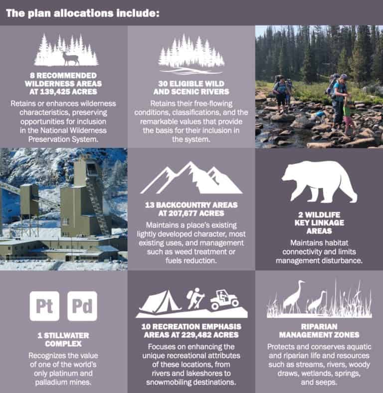
The agreement details a future for the Gallatin and Madison Ranges that protects wildlife, clean water, wilderness and recreation opportunities through recommended protections and wildlife management areas. Specifically, the document incorporates new land protections that will help guard clean water and ensure safe passage for wildlife while maintaining existing recreational opportunities and seeking to limit new development.
“[The partners] came to the table with a spirit of ‘let’s work something out’ and we did,” Johnson said in a Feb. 7 interview. “I’m tremendously proud to have been a part of that. And given what’s going on in the country these days, anything that actually comes to an agreement amongst disparate parties is sort of a miracle.”
Leuschen-Lonergan explained that the recommended wilderness and type of land allocations drew some of the most diverse perspectives and sparked the most disagreements. The balance of sustainability and preserving public access struck by the plan was informed by focusing on the common ground in the extensive public comment received by the forest.
“It was a pretty lengthy process, and we’re very thankful and fortunate to have people … across the Custer Gallatin, all seven districts, that really care about and are passionate about these public lands and want to be involved in the process,” she told EBS. “Because of that, we were able to build a more … inclusive and robust plan that as we move forward for the next 10 to 15 years, incorporates a lot of people’s thoughts and perspectives and is a better plan because of the involvement that we had.”
This article looks like an international take on U. S. renewable energy development and has links to the new MOU among five federal departments (including USDA/Forest Service) and the Energy Policy Act of 2020. I was going to add this to Sharon’s recent post on renewable energy, but I wanted to highlight the planning implications.
This MOU implements the direction in 43 U.S.C. §§ 3001-3005, Pub. L. No. 116-260 (December 27, 2020), hereinafter “Energy Act of 2020.” Pursuant to the Energy Act of 2020, the Secretary established a National Renewable Energy Coordination Office (National RECO) within BLM Headquarters and five RECOs in the western States with responsibility to implement a program to improve Federal permit coordination for eligible “projects.”
It applies to “relevant aspects of Participating Agency coordination related to supporting activities for eligible projects—such as land use planning …,” which for the Forest Service it defines as “a land management plan approved, amended, or revised under section 6 of the FRRRPA (16 U.S.C. §1604).” (Applying this label to NFMA suggests pretty limited FS involvement.)
It requires a report to Congress identifying “outdated land use plans,” and requires BLM (but not the Forest Service) to “identify land use plans that may need to be amended as part of the decision-making process to consider eligible projects…” But maybe BLM will identify outdated Forest Service plans.
I hope this right hand of our government (a legacy from the prior administration) is talking to the left hand about where it wants to conserve 30% of the land.
(New case.) In a December 7 lawsuit against the U.S. Department of Labor, a group of Colorado river guides claim the federal government has arbitrarily imposed a $15 minimum wage on the outdoor industry, rendering extended tours through public lands less attainable. The article includes a link to the complaint.
(New case.) On November 29, the Center for Biological Diversity sued the U. S. Fish and Wildlife Service over a Trump administration rule that expanded hunting on national wildlife refuges when it determined that listed species found in or near the refuges would not be adversely affected by the expansion. Species mentioned the grizzly bear, jaguar, ocelot, jaguarundi, Audubon’s crested caracara, wood stork, and whooping crane. The article includes a link to the complaint.
(Update.) The U.S. Fish and Wildlife Service and multiple conservation groups reached an agreement to conduct a new Endangered Species Act status review of California spotted owls by Feb. 25, 2023. The stipulated settlement stems from a suit the Center for Biological Diversity and other groups filed against the Trump administration in 2020 for not adding the spotted owl to the list of endangered species.
(Follow-up.) A proposal to add the Pearl River map turtle to the federal endangered species list was published on November 23 by the U.S. Fish and Wildlife Service after two environmental groups sued the agency last year for missing the determination deadline by a decade. The proposed listing (the article contains a link) mentions the Bienville National Forest in Mississippi favorably.
The U.S. Fish and Wildlife Service (Service) published a final rule revising the critical habitat designation for the northern spotted owl. The final rule rescinds a previous rule issued by the Trump Administration on January 15, 2021, which would have excluded approximately 3.4 million acres from the species’ critical habitat designation. We talked more generally about critical habitat and spotted owls here. Related litigation was discussed here.
Oregon Democratic Sens. Jeff Merkley and Ron Wyden announced legislation to establish a new national monument in central Oregon on BLM lands. According to Merkley’s press release, the proposal has the support of several conservation groups as well as the city of Mitchell, which has seen economic benefits from Painted Hills tourism and visiting cyclists.
The Rio Grande National Forest announced the inclusion of an administrative change in its revised forest plan. The change addressed recently acquired lands that were not included in the Rio Grande National Forest’s land base when the plan was revised.
The 2012 Planning Rule allows administrative changes for “corrections of clerical errors to any part of the plan, conformance of the plan to new statutory or regulatory requirements, or changes to other content in the plan (§219.7(f)).” Hmmm.
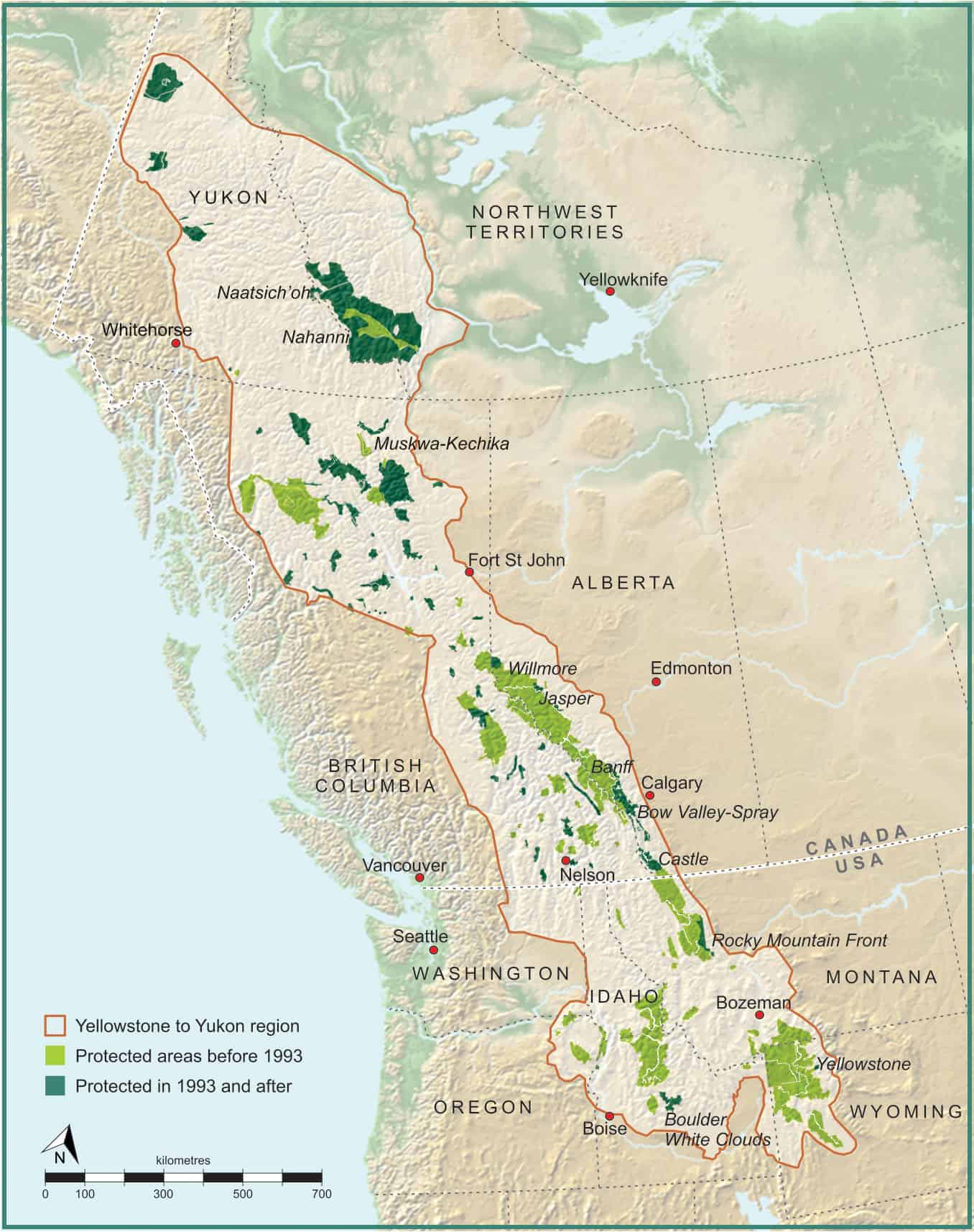
I watched a webinar provided by the Center for Large Landscape Conservation titled “Legal Protections for Large Landscape Conservation,” part of which focused on “Habitat Connectivity and the U. S. Forest Service.” That segment can be seen here from 4:15 to 19:05. The presentation goes over the elements of Forest Service planning that could be useful for habitat connectivity. It includes a couple of examples of “innovations” from the Flathead and Carson/Santa Fe forest plan revisions, but concludes that few plan components that address connectivity are likely to be very effective. It cites a familiar refrain that the agency is “unwilling to commit to specific direction,” and “lack of commitment and interest from line officers.” However, the presenter observed that the movement of the Forest Service toward more centralized planning organizations might provide an opportunity to look at connectivity as a broader regional issue, and to develop regionally consistent approaches to planning for connectivity.
What if the Forest Service was actually interested in conserving the species that use its lands but require connectivity across other jurisdictions and ownerships (as it is required to do, “in the context of the broader landscape,” a phrase used seven times in the 2012 Planning Rule ), and what if the Forest Service played a leadership role in facilitating such cross-boundary connectivity by promoting large-landscape conservation strategies?
Maybe it would look something like what the Yellowstone to Yukon Initiative has accomplished since it began promoting large-scale landscape conservation in 1993. As Rob Chaney reports in the Missoulian, they have recently evaluated the effectiveness of their program in “Can a large-landscape conservation vision contribute to achieving biodiversity targets?” They found that in the Y2Y region where landscape connectivity was actively promoted, more public lands were dedicated to protection, more private lands were protected, wildlife highway crossing structures proliferated, and occupied grizzly bear habitat (as a proxy for actual benefits to wildlife) expanded.
Come to think of it, wouldn’t that be a great assignment for the Biden Administration to give the Forest Service (both the National Forest System and State and Private Forestry divisions) to promote its 30 X 30 conservation agenda?