Nevada-Wide RMP Revision: Planning Challenges and Solutions for the BLM

With apologies to those of you not interested in the Planning Quagmire..

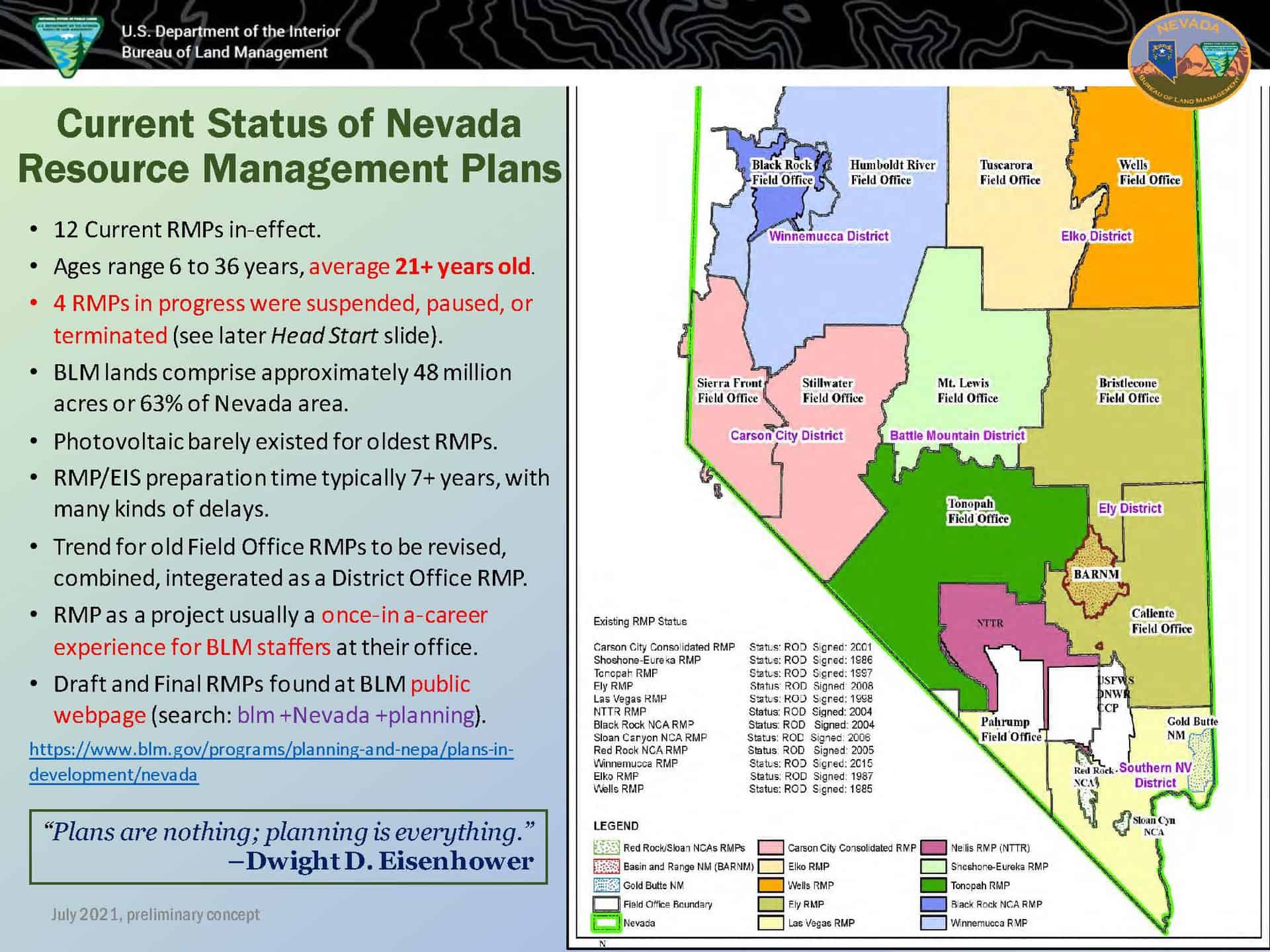
Susan Jane Brown in this comment “is it really a NFMA problem, or is this a multiple use problem?”  So the answer would be to look at another multiple use agency (in this case, FLPMA and BLM) and see if they have problems finishing their plans.  My experience was that our State Office was more intent on finishing (more sticks in the bundle? sharper sticks?) than our Regional Office was, but that varied by FS personnel.  We even had a joint plan for a while (RMP and Plan Revision) on the San Juan. The San Juan worked very hard on it, with a great deal of creativity, but as I recall someone stuck a fork in it.. can’t  remember exactly why.  Anyway, I found this interesting powerpoint from last summer by BLM Nevada. Here’s one slide.

Advantages of a Single RMP Revision

Efficiency of scale to meet timeline goal for completion by October 2025.
Implements recent Executive Orders and meets Department of Interior Priorities.
Brings half the current RMPs into the 21s t Century –including Elko and Battle Mountain Districts, which are still living in the ’80s– while resolving RMPs that no longer address current issues.
Avoids continuations of serial, piecemeal RMP amendments, such as for Winnemucca District Visual Resource Management and Southern Nevada District land disposals.
Assures consistency throughout Nevada for criteria, such as leasing or permit stipulations.
Harmonizes with concurrent planning to start by Humboldt-Toiyabe National Forest, covering 5.6 million acres of mountain ranges in Nevada surrounded by BLM lands.
Incorporates existing, disjointed RMP Amendments into a single plan, including the widespread Greater Sage-Grouse Plan Amendment of 2015, which functions like a separate planning overlay.
Integrates latest standards for geospatial and corporate data, accessible through a map-based public website that can be continuously updated as a “living document” encapsulating future amendments.
Reduces risk and adds specificity to RMP conformance statements that may be based upon overly broad and outdated criteria in older RMPs.
Satisfies long pent-up demand for updated, revised RMPs. Finally gets it done.


Potential Disadvantages & Risks of a Single RMP Revision

o
Legal challenges may drag the whole RMP/EIS, although risk reduced with multiple RoDs.
o
Funding continuity less certain for sequential Fiscal Year allocations.
o
Workload heavy for Nevada State Office and increases for District Offices.
o
Whole efforts seems too formidable for ambitious timeline, thus requiring a firm Project Manager.
o
Implementation-level decisions would not fit into the RMP and would have to be separate

Here’s another slide:

Meeting Department of the Interior priorities RMP to implement recent Interior Priorities, encapsulating multiple use with sustained yield per FLPMA goals.
Tentative slogan: Planning is cool again to tackle the climate crisis…. (nod to Executive Order 14008, 27 Jan. 2021)

 Identifying steps to accelerate responsible development of renewable energy on public lands and waters.
 No BLM State has more solar applications pending. RMP to feature Designated Leasing Areas (DLAs) and/or Project Development focal areas, new or confirmed transmission corridors, recognition of ongoing projects already initiated.
 Energy Act of 2020: RMP supports national goal of 25 GW additional renewable energy generation nationwide by 2025.
 Integrate with State of Nevada initiatives (e.g., Renewable Portfolio Standard, 2020 State Climate Strategy).
 Strengthening the government-to-government relationship with sovereign Tribal nations.
 Early, targeted outreach for public and tribal engagement through RMP envisioning or pre scoping.
 Tribes invited to be Cooperating Agencies as a supplement to formal Consultation.
 Requests from Tribes represented within the RMP range of Alternatives.
 Making investments to support the goal of creating millions of family-supporting and union jobs.
 Objectives and specific projects, including infrastructure, identified for on-the-ground actions and business opportunities.
 Projects may be carried out by Climate Conservation Corps, AmeriCorps, non-profits organizations, and/or private firms, especially for activities or actions identified as Implementation Strategies a few months after RMP completion.
 Working to conserve at least 30% each of our lands and waters by the year 2030. (America the Beautiful or 30 x 30 Initiative)
 Planning designations for conservation and climate goals, such as via Areas of Critical Environmental Concern (ACECs),
Backcountry Conservation Areas (BCAs), Habitat Conservation Plan (HCP) areas, Wilderness Character (LWC) units, etc.
 Land use designations, including mitigation sites, serve as an Administrative method for conservation, thus informing any subsequent, more durable conservation via Executive Action or Federal Legislation. See Wilderness Society example.
 Centering equity and environmental justice.
 Appropriate, close scale to identify Environmental Justice communities with latest census and other population data.
 Targeted outreach conducted, with public meetings brought to EJ communities in rural and urban areas.

It almost sounds as if the RMPs also do a variety of things at different scales.. picking where solar should go and what land should be “protected” prior to Executive Action or legislation for “durable” conservation. That seems like an extremely useful exercise, but identifying “specific projects” might be at a different scale. Nevertheless, we can tell from the slide pack that “getting plans done” has also been a challenge to the BLM, which fits in with SJB’s idea. And/or perhaps both NFMA and FLPMA need another look?

And with target dates for renewable installations being urgent, it seems like the BLM might have its own “climate emergency (fast action) meets land management planning (slow action)” challenge. (not that they don’t have fire issues as well.)

Reducing fuels and advancing equity

Here’s an interesting paper from the PNW Research Station….

Reducing Fuels and Advancing Equity: Incorporating Environmental Justice Into Hazardous Fuels Management

“The researchers … assess the distribution of benefits to local populations created by 10 years of fuels management on 12 national forests in the Western United States. They found that, for the most part, the 12 national forests equitably distributed benefits from fuels reduction projects. However, each for­est had one or more “hotspots” where a localized lack of benefit for concentrated racial or ethnic minority populations raised environmental justice concerns. Interviews with Forest Service manag­ers provided insight into why hotspots occurred and revealed how environmen­tal justice could be more effectively inte­grated into land management procedures.”

NFS Litigation Weekly October 22, 2021

After about six weeks we have another summary from the Forest Service.  The Forest Summary is here:  NFS Litigation Weekly October 22 2021 EMAIL

It only covers two recent cases, so I’ve filled in some other happenings from early October below.

COURT DECISION

Swomley v. Schroyer (10th Cir.) — On October 15, 2021, the 10th Circuit Court of Appeals affirmed the District Court of Colorado’s September 3, 2020 order upholding NEPA compliance for the Upper Fryingpan Vegetation Management Project on the White River National Forest, challenged by 21 nearby residents who used the area for recreation.  Additional background is in this article.

NEW CASE

Umpqua Watersheds v. Chambers (D. Oregon) On October 14, 2021, Umpqua Watersheds, Cascadia Wildlands, and Oregon Wild filed a complaint in the District Court of Oregon against the Forest Service regarding the Archie Creek Fire Roadside Danger Tree Project on the Umpqua National Forest. The claims focus on whether a large-scale salvage logging project constitutes road “repair and maintenance” eligible for a categorical exclusion, and on consistency with the Northwest Forest Plan in late successional and riparian reserves.


BLOGGER’S BONUS

Court decision in Alliance for the Wild Rockies v. Marten.  On October 5, the district court for the District of Montana adopted the magistrate judge’s findings and enjoined the Soldier-Butler Project on the Lolo National Forest because it was not consistent with the forest plan and also violated ESA.   (I’ve provided a more detailed summary of the forest planning implications of this case below.)

Court decision in Sequoia ForestKeeper v. U.S. Forest Service.  On October 5, the district court for the Eastern District of California adopted its reasoning from its prior decision to grant a TRO (discussed here) to grant plaintiff’ motion for a preliminary injunction against the Plateau Roads Hazard Tree Project on the Sequoia National Forest:  for the reasons that the Ninth Circuit explained in EPIC, allowing for large scale tree removal projects is inconsistent with the purposes of categorical exclusions …”  (The TRO decision was described on this blog here.)

New case:  Center for Biological Diversity v. Feldhausen.  On October 6, the Center for Biological Diversity and Maricopa Audubon Society sued the U.S. Bureau of Land Management in the District of Arizona for failing to protect the Huachuca water umbel, a semi-aquatic endangered plant, from livestock grazing in the San Pedro Riparian National Conservation Area.  The complaint alleges that failing to fence cattle out of the area violates BLM’s affirmative duty under section 7(a)(1) of the ESA to utilize its authorities to carry out an essential program for the conservation of this endangered species.  (The news release includes a link to the complaint.)

New case:  Center for Biological Diversity v. U. S. Bureau of Land Management.  On October 7, the Center for Biological Diversity and Maricopa Audubon Society sued the U.S. Bureau of Land Management and Fish and Wildlife Service in the District of Arizona for failure to reinitiate ESA consultation on the effects of livestock grazing on threatened and endangered species in the Gila Box Riparian National Conservation Area in southeastern Arizona. Plaintiffs also include a Freedom of Information Act claim.  (The news release includes a link to the complaint.)

New case:  Center for Biological Diversity v. U. S. Environmental Protection Agency.  On October 4, The Center for Biological Diversity sued the EPA for issuing a Clean Water Act permit without fully assessing the risks posed to freshwater endangered species by pesticides applied directly to water.  The nationwide “pesticide general permit” establishes the requirements for pesticide applications directly to water for purposes including forest canopy pest control.  (The news release includes a link to the petition for review by the Ninth Circuit Court of Appeals, as provided in the Clean Water Act.)

SOLDIER-BUTLER (Alliance for the Wild Rockies v. Marten, D. Mont.)

Finalized in April 2020, the Soldier-Butler project on the Lolo National Forest would burn and thin about 10,000 acres and harvest 18 million board feet.  The Forest Service intended to build 7 miles of new roads, 9 miles of temporary roads and it rescinded a previous commitment on the adjacent Frenchtown Face project to decommission 37 miles of existing road.

The forest plan included two standards for elk winter range within the project area that said, “Retain as a minimum a 50:50 coverage:forage ratio. The majority of cover should be thermal cover, that is, trees greater than or equal to 40 feet tall with a crown density greater than or equal to 50 percent.”  The Forest Service first argued that this was just a goal that could yield to other competing uses, but the court said, “the Forest Service’s failure to comply with a forest plan’s goal may very well constitute a NFMA violation,” citing a 9th Circuit precedent.  However, the court also concluded that, “a minimum 50:50 coverage:forage ratio be retained is about as close to a standard as it gets.”  While the other language in this standard is more goal-like, the court concluded, “the record is not sufficiently developed to permit this Court to make the call one way or another. Accordingly, the Project violates NFMA.”

The Forest Service also tried to argue that, because they had documented that the project would not provide the 50:50 ratio, they would not implement some of the activities from the project.  The court found that, “the record simply did not reveal how these alternative measures would ensure the Project complied with the Forest Plan’s 50:50 coverage forage ratio standard.”  While the court would not require a particular methodology, it said, “Defendants have not provided any updated calculation at all. The Court cannot simply take Defendants’ word.  In other words, Defendants need to show their work.”

Another standard said, “Provide stands at least 30 to 40 acres in size that are decadent, multi-storied, fully stocked, contain snags with dead and down material greater than 15 tons per acre, and contain 15 trees per acre greater than 20 inches d.b.h.”  The Forest Service tried to argue that this did not apply to the Project because there were no existing stands that met these criteria.  The court found that interpretation to be inconsistent with the language of the standard that applied it to this management area to protect old-growth dependent wildlife species.  Since the project could result in the loss of snags, the Forest Service needed to explain how it would meet this standard, but failed to do so.

Reinitiation of ESA consultation on the forest plan is necessary because the Project was potentially not compliant with the incidental take statement for the 2012 grizzly bear forest plan amendment.  The court noted, “Defendants have not pointed to any authority supporting the notion that site-specific analysis absolves them of their obligations to comply with the governing forest plan.”

Additional plan consultation is necessary to address 137 miles of “undetermined roads,” because there was no evidence that these roads had been addressed, or even been in existence, for the 2012 consultation when the baseline amount of roads was established.  Since the baseline is unclear, it is not possible to tell if the incidental take limit for the forest plan has been exceeded by this Project.  While that limit only applies to public roads, there is evidence that some of these “undetermined” roads are actually public roads that would be subject to this limit.

In addition, the site-specific 2020 Project Biological Opinion did not adequately consider the Project’s reversal of a prior decision to decommission 37 miles of roads.  The Forest Service argued that these roads were a prior federal action and therefore are not considered cumulative effects under ESA, but the court held that undoing that prior decision was a direct effect of this Project, and must be considered in consultation.   This is true regardless of the possibility the Forest Service would not have implemented the road decommissioning decision, because the court must assume that, “Forest Service will abide by ‘legally-binding commitments . . . [made] in a record decision.’”


You Can’t Pull a Fire Engine with a Dead Horse: Are Plan Revisions a Roadblock to Dealing With Fire Planning? AND A Bipartisan Window to Revise NFMA?

Reading this article by Marc Heller of E&E News on Chris French’s testimony (well worthy reading in its entirety), I had flashbacks to many previous discussions, including my all-time favorite The Smokey Wire post.. Andy Stahl’s KISS Rule, from 2009.

I’d like to express two caveats here.  One is that I’m assuming Marc got it right; and that if I watched the hearing, I would get the same impression. As much as I like this stuff, I do not want to watch the whole thing, so if someone would like to do that, I encourage you to do so and report back.  The other is that French’s testimony has been cleared by the Administration (as is the standard process), so that determines the FS position. It would not be unduly political to suggest that what I might call “plan-olatry” derives more from external groups than inside the Forest Service.

Basically the “can-do” Forest Service was saying that “we can’t”, at least,  they can’t without plan revisions and there’s no way to hurry them up. I’ve never really heard the FS have a can’t do attitude, no matter how strange or difficult the request from the powers that be.


Of the 154 land management plans the Forest Service follows nationally, more than half are at least 15 years old, French said in response to questions from committee Chair Joe Manchin (D-W.Va.).

And while the Forest Service has updated 35 plans and is in the process of updating 19 more, it doesn’t have enough staff or money to catch up on the others, even with the help of contractors, French said.

“We just can’t pay for those positions anymore,” French said, adding that the Forest Service has recently seen a decline of about 40 percent in natural resources professionals who work on the management plans.

The delay in forest plans has on-the-ground implications for wildfire and other issues, as the documents shape policies on forest thinning, prescribed fire, timber harvests and other measures that have fire implications, especially in the fire-prone West.

In an era of wildfires and other challenges driven in part by climate change, land management plans may not embrace new solutions, although they can be amended from time to time. French said a full land management plan update typically takes from six to eight years.

Manchin, appearing frustrated at the logjam, asked French whether the agency could seek help from contractors — which the deputy chief said it already does — and whether the Senate could do more to help.

“Everybody, Democrat and Republican, is all for this, so all we need is your-all’s cooperation,” Manchin said.

Congress has appropriated $540 million to the Forest Service for land management plans in the past three years, Manchin said. But much of that money goes to efforts like environmental reviews, leaving just $40 million to $50 million for actual land management planning, French said.

To address the backlog, French said, the agency is taking a new approach — beginning this week — that’s based on regional, rather than forest-by-forest, analysis.

My bold.  I can see why the regional approach is being considered, but it’s one more step away from the residents and stakeholders on the ground. And I can imagine that some forests might get shorter shrift than others (imagine east side versus west side in Oregon, say.) Are we repeating the errors of the past? And if it’s not really “forest” planning, what is it?

Earlier I posted this “Fire Planning Amendments with EISs” approach that would seem to satisfy most ENGO’s. So the FS could do what needs to be done fire planning wise, and wait for a better solution to the revision problem, by doing a stand-down on plan revisions for now.

After all, it’s an emergency, and a unique window in which the FS has the bipartisan attention of Congress. The Admin could develop a FACA committee, with public comment, built on “do plans do anything useful to anyone?” (not “how to tweak the 2012 Rule?”) and starting there on revisions to NFMA. The Biden Administration has at least three years to do it and make it through the window.

Talk about an opportunity for the Administration to leave the government in a better place than they found it, and to do something with bipartisan support!

The election is in 2024 and in 2026 NFMA will be 50 years old. It’s not the latest planning science…plus conditions have also changed greatly. Perhaps it’s time to put it out to pasture.

The whole article is here.

Public Lands Litigation Update – September 2021

Nothing from the Forest Service for September, but here’s what I’ve seen.  (Links are to articles, news releases or court opinions.)

FOREST SERVICE

(Court decision in WildEarth Guardians v. U. S. Forest Service.)  On September 10, the federal court for the Eastern District of Washington denied a challenge to the Colville National Forest revised forest plan’s direction related to livestock grazing and gray wolves because the plaintiffs could not show they were injured without a site-specific grazing decision based on the revised plan, and because the state “is the lead agency primarily responsible for wolf management operations.”  The court also upheld ESA consultation compliance for whitebark pine, Canada lynx and grizzly bears.

(Court decision.)  On September 21, the Ninth Circuit Court of Appeals affirmed the dismissal of a case filed against the Bitterroot National Forest by two landowners contesting the scope of a Forest Service road easement across their land because they failed to meet the 12-year statute of limitations under the Quiet Title Act for making their claims.

(Court decision.)  On September 21, the federal district court of Wyoming determined that the Bridger-Teton National Forest had improperly authorized the State of Wyoming to feed elk on two winter feedgrounds because they did not appropriately analyze the harmful impacts of concentrated feeding on wildlife, including the increased risk of transmission of lethal chronic wasting disease.

(New lawsuit.)  On September 21, the Alliance for the Wild Rockies filed a lawsuit in the Montana federal district court against the Ripley logging project on the Kootenai National Forest near the Cabinet-Yaak grizzly bear recovery zone.

(Court decision in Yaak Valley Forest Council v. Vilsack.)  On September 28, the federal district court for Montana ordered the Kootenai National Forest to comply with the requirements of the National Trials System Act after nearly a decade of delay by preparing a comprehensive plan for the Pacific Northwest National Scenic Trail by December 31, 2023.  The Forest could not rely on its forest plan to meet this requirement.

BLM

(New lawsuit:  Center for Biological Diversity v. U. S. Bureau of Land Management.)  On September 16, five environmental groups sued the Interior Department, Bureau of Land Management and U.S. Fish and Wildlife Service regarding the 2019 West Mojave Route Network Project and plan amendments for violating NEPA, FLPMA, and ESA when authorizing off-road vehicle use and cattle grazing in the California Desert Conservation Area.  (The news release includes a link to the complaint.)

FISH AND WILDLIFE SERVICE

(Notice of intent to sue.)  On September 8, three environmental groups filed a notice of intent to sue over a delayed response to their 2020 petition seeking to list the Alexander Archipelago wolves under the Endangered Species Act.  Alleged threats to the wolves include “the intensive clear-cut logging of old-growth forests on the Tongass National Forest” and associated road construction, and loss of regulatory “protections from the 2001 Roadless Area Conservation Rule on the Tongass National Forest.”  (A link to the notice is included in this article.)

(Court decision in WildEarth Guardians v. Haaland.)  On September 20, the district court for the Central District of California invalidated the decision by the U. S. Fish and Wildlife Service to not list the Joshua tree as threatened or endangered.  The court held that the agency’s determination that climate change doesn’t threaten the trees to such an extent to warrant protection was arbitrary and capricious.  (The court’s opinion is here.)


Sac Bee Editorial: “Rogue environmentalists put Californians in harm’s way by blocking forest thinning projects”

Excerpt from an editorial by The Sacramento Bee Editorial Board:

Century-old forest management practices by the Forest Service, Cal Fire and the logging industry have led to intense standoffs in recent decades among environmentalists, scientists and fire experts who believe we have managed our forests under a profit motive, not resiliency.

They are not necessarily wrong. As The Bee’s Ryan Sabalow and Dale Kasler noted in a recent story about this conflict, “much of the sturdy old-growth was cut down, and what grew back in its place were dense stands of small trees and brush,” they wrote. “The stage was set for an era of catastrophic fires like the sorts California is experiencing every summer.”

In addition to fighting fires instead of controlling them, the Forest Service allowed logging companies to decimate California forests for much of the 20th century, with little concern about the ecological harm they were causing. This gave environmentalists all the ammunition they needed to question the motives of an agency that oversees millions of acres of California forestland.

But now is the time for the environmental left to stand down. California’s forests are in terrible shape after decades of unchecked commercial logging and aggressive fire suppression. Conditions have only gotten worse as climate change dries our forests and reduces rainfall, aiding recent record-breaking megafires that threaten populated areas and wipe out entire habitats.

By weaponizing federal protections — such as the National Environmental Policy Act and the Endangered Species Act — to obstruct or outright kill various wildfire prevention projects, environmentalists imperil the very ecosystems they wish to protect.

Organizations like the John Muir Project, Conservation Congress and other allied groups have been accused by leading experts of spreading “agenda-driven science” that promotes specific unsupported narratives and avoids data to back up their litigious claims. At least 111 scientists have co-authored at least 41 scientific papers to rebut their dubious methods, The Bee reported, an extraordinary sign of how problematic these groups have become. Some of their disputed claims have caused the courts to delay important fire prevention projects.


The Western Housing Crisis and WUI Development

A small community of campers outside on Cortez, Colorado in October, 2021. (Dean Krakel, Special to The Colorado Sun)


Populations in many western states are increasing dramatically, putting pressure on communities to develop housing. What kind and where? And will it be in the WUI? What I like about this issue is that there are no predetermined good guys and bad guys and not much in the way of partisan vitriol (if any). Shout out to the Colorado Sun for their coverage.

Here’s an example from Billings, MT.

Here’s one from  Silverton, CO in the Colorado Sun:

Local officials are developing an attainable housing project, but for now workers have been pushed toward RVs, cars and other more desperate living situations, as a housing crunch that began years ago snowballed when urban dwellers moved to more remote locations during the pandemic.

DeAnne Gallegos, executive director of the Silverton Chamber of Commerce, is candid about how some residents are living.

“It’s glorified homelessness, let’s be honest,” she said.

Clark Anderson, executive director of Community Builders, a nonprofit helping Silverton develop a master plan, said the town and other parts of Colorado have a workforce housing market competing directly with that for high-end luxury homes. Prices overall have shot up in part due to short-term rentals, like through VRBO. Developers tend to cater to the affluent because they have investors or are trying to make a profit, he said.

“You don’t find that many developers that are going to say, ‘You know, I know that houses are selling for $1 million here but I want to really focus on building $400,000 homes,’” Anderson said.

The trend has been building for years, as communities across the West have failed to keep pace with housing demand, after overbuilding in the past.

Harper, whose family owns the Grand Imperial Hotel and the Durango & Silverton Narrow Gauge Railroad, understands why there’s so much demand for housing.

“We live and work in a postcard and we’re blessed — those select few of us that get to live here,” he said.

This Colorado Sun piece focuses on some policy solutions to the short-term rental market in mountain towns in Colorado.

And another Colorado Sun piece that focuses on Durango, Colorado.

Another 50 miles to the west, Reece Blincoe holed up in an RV with his 60-pound bernedoodle, Bernie, for three weeks because he couldn’t find housing before he started work as superintendent of schools in Dolores. He shuttled back and forth to a storage trailer where he kept clothes that wouldn’t fit in the RV.

“When your superintendent comes to town and has to live in an RV for three weeks, that kind of shows you what we’re dealing with here,” said Blincoe, who eventually found housing with the help of a school board member.

Lack of housing has reached a crisis point in parts of southwest Colorado, where a shortage of places to buy or rent affordably is keeping critical businesses and organizations from hiring and retaining workers. Some residents have resorted to living in cars or on campgrounds, and local officials fear middle-income earners will be priced out of the housing market.

Now the idea that people move from somewhere else, and boost prices so that residents can no longer afford to rent, and are priced out of buying, is nothing new to many places in the West. In fact, here’s a 2018 story about Californians moving to the NW and arousing local ire.  Remember,  in 1971, Governor Tom McCall invited tourists to visit Oregon, but then added “but for heaven’s sake don’t stay. ” And here we are, fifty years later.

Now, however, there seems to be a tension between “people shouldn’t be moving there because it’s a fire-prone landscape” and the fact that people are moving to the west because.. it’s a nice place to live, and amenity migrants particularly like being near federal lands (who wouldn’t?). The solution proposed by some is to densify western cities.

Building more dense housing units in the core of Billings, for example, could provide numerous opportunities for the community, she said, bringing more people into the heart of downtown, revitalizing the area and driving economic growth while appealing to younger workers seeking a more livable and walkable community. One focus for BSED is looking into the expansion of mixed-use properties with small businesses or retail at street level and apartments above.

“I wouldn’t say there’s any area that wouldn’t be ideal for developments,” Lehm said. “I would think we’re going to see more housing choices for downtown.”

Lehm also pointed to more innovative ways of addressing housing shortages than single-family home expansion in the suburbs. Land trusts, housing co-ops and redevelopment of downtown could all be parts of the solution. Several of those methods are being explored through small-scale programs in other Montana cities. Both Kalispell and Red Lodge have begun land trust programs to develop affordable housing.

It seems to me that there are several things about single-family homes that have made them attractive to people, ownership (not dealing with landlord-related issues; not worrying about rent going up and having to move, and so on) and space (for children, dogs, gardens, etc.). Home ownership, as Jennifer Hernandez pointed out in her piece Green Jim Crow about California, has also been the major source of wealth accumulation for people at the lower end of the economic ladder.

“about 54 percent of all renters in California, housing costs exceed 30 percent of household income, the traditional definition of housing affordability.[9]Nearly 70 percent of all state households with unaffordable housing costs consist of people of color.

Racial inequality is exponentially magnified by housing. Housing equity makes up nearly 60 percent of the total net worth of minority homeowners compared with 43 percent of White homeowner wealth.[10]Black, Latino, and other historically disadvantaged groups rely on mortgage payments to build wealth through homeownership while also paying for necessary housing; there is little to no excess cash available to buy stocks, bonds, and other assets.

So I think that having affordable single family homes is important in terms of social justice, even if the development of such housing occurs on formerly wild or agricultural land.  I don’t think people think about “WUI development” necessarily in terms of affordable home ownership, but in many places it is.

$10 Billion in Which WUI?: Reading Comprehension Check

This is the 2010 map (published in 2015) of the area around Crestone, CO from the website posted yesterday.

Speaking with folks in DC last week, it sounds as if we don’t know a) if forest provisions will end up in the bill or b) which ones those are. But given that context, I’d still like to understand what they intend (ed?). But I don’t know that for sure.. perhaps someone out there has more updated information?

A simple reading of the bill as posted here takes this paragraph:

“$10,000,000,000 for hazardous fuels reduction projects within the wildland-urban interface;”

and this definition of WUI

(10) WILDLAND-URBAN INTERFACE.—The term ‘‘wildland-urban interface’’— 22 (A) in the case of the lower 48 States,
23 means the areas mapped as the wildland-urban 24 interface in the document entitled ‘‘The Wildland-Urban Interface of the Conterminous
United States’’, and published by the Department of Agriculture in 2015; and
3 (B) in the case of the States of Alaska and
4 Hawaii, has the meaning given the term in section 101 of the Healthy Forests Restoration 6 Act of 2003 (16 U.S.C. 6511).

So given the maps and the definitions from the 2010 mapping (published in 2015 with 2010 data) that we looked at yesterday that shows, and defines WUI, as already having houses… I wonder whether there is any NFS land in the 2010 mapped WUI to be treated?

If you’re in Alaska or Hawaii, though, apparently you get to use the HFRA definition, with which many of us are familiar (and may be the first thing that comes to mind when someone says WUI, especially related to fire).

A community gets to designate it via a CWPP (community wildfire protection plan) or otherwise it’s this default:

HFRA has a default definition of WUI (Section 101(16)(B (ii)). It is an area:

Extending 1/2 mile from the boundary of an at-risk community.
OR

Extending 1 1/2 miles from the boundary when other criteria are met—for example, a sustained steep slope, a geographic feature that could help when creating an effective firebreak, or Condition Class 3 land.
OR

Adjacent to an evacuation route. There is no distance limitation for evacuation routes.

Fortunately it appears that the at-risk community definition is the same.
“AT-RISK COMMUNITY.—The term ‘‘at-risk 6 community’’ has the meaning given the term in section 101 of the Healthy Forests Restoration Act of
8 2003 (16 U.S.C. 6511).”

So for the lower 48, clearly it was intentional to use the 2010 maps instead, but the maps may not (are likely not to?) have any FS land on them. Was this intentional, or am I misunderstanding it?

WUI Definitions and Maps From the Forest Service Northern Research Station

WUI map from Silvis Lab at U W Madison.. you can check out your own area. This is west of Denver.
When we explore new ideas and abstractions, it’s best to start with a definition. The first and currently ongoing (updating with 2020 data as we speak) is this group at the Northern Research Station and cooperators. It should be noted that residential and other development has a host of other impacts, but this mapping is specifically designed to inform fire policy. As we noted last week, at one time the Reconciliation Bill had this map as the delineation for FS funding (that is, the 2010 mapping published in 2015) 10 billion-wise and the Sec would have to say they’d completed all those projects before the FS could use the $4 bill outside those boundaries.

The Wildland-Urban Interface Defined
Although the idea of a wildland-urban interface is easily understood and the term widely used, a specific definition is needed to determine where it occurs and map its location. The definition we use here, as in earlier map projects, is designed to inform fire policy and management. It is based on a report prepared for the Council of Western State Foresters on WUI fire risk (Teie and Weatherford 2000) and was later published in the Federal Register. The WUI is composed of both interface and intermix communities. The distinction between these is based on the characteristics and distribution of houses and wildland vegetation across the landscape. Intermix WUI refers to areas where housing and wildland vegetation intermingle, while interface WUI refers to areas where housing is in the vicinity of a large area of dense wildland vegetation.
For more detail, see Box 1.

Box 1.—Definition of WUI and non-WUI land-use classes.
WUI Definition
Intermix Areas with ≥6.18 houses per km2 and ≥50 percent cover of wildland vegetation
Interface Areas with ≥6.18 houses per km2 and <50 percent cover of vegetation located <2.4 km of an area ≥5 km2 in size that is ≥75 percent vegetated Non-WUI, Vegetated No housing Areas with ≥50 percent cover of wildland vegetation and no houses (e.g., protected areas, steep slopes, mountain tops) Very low housing density Areas with ≥50 percent cover of wildland vegetation and <6.18 houses per km2 (e.g., dispersed rural housing outside neighborhoods) Non-Vegetated or Agriculture Low and very low housing Areas with <50 percent cover of wildland vegetation and density <49.42 houses per km2 (e.g., agricultural lands and pasturelands) Medium and high housing Areas with <50 percent cover of wildland vegetation and ≥49.42 houses density per km2 (e.g., urban and suburban areas, which may have vegetation, but not dense vegetation)

What you might notice is that WUI on these maps can be adjacent to grazing lands or agricultural lands. Which doesn’t seem to fit the definition above, so this is more complicated than it might appear. Certainly acres of WUI next to corn fields or a grassy pasture have different fire characteristics than, say, a ponderosa forest.

This 2007 paper by Stewart et al. has a literature review and some history on the WUI concept.

Throughout its evolution, the WUI definition always includes three components: human presence, wildland vegetation, and a distance that represents the potential for effects (e.g., wildland fire and human activity) to extend beyond boundaries and impact neighboring lands. Beyond these three components, most WUI discussions are imprecise regarding what is or is not included. For example, human presence has been defined by housing density, population density, number of houses, or configuration of housing developments and neighborhood characteristics. Wildland vegetation is always mentioned, but the density, extent, and type of vegetation that makes some vegetation “wildland vegetation” is not well defined. The distance that the WUI extends into wildlands or into a housing development has been described in many different ways, including the distance a golf ball will fly off the porch or the distance from which flames or firebrands can reach a structure (Summerfelt 2003), but specific distances are rarely given.

It’s interesting to look at your neighborhood and compare the 1990 and 2010 maps. Observations?