Honeybees on public lands?

Western bumblebee (Xerces Society / Rich Hatfield)

The rusty-patched bumblebee and Franklin’s bumblebee have been listed under ESA and other species are being considered.  The Xerces Society considers 11 species of bumblebee to be at-risk.  The Forest Service and BLM allow special use permits for non-native honeybee apiaries on their lands based on categorical exclusions.  Here is the one applicable to the Forest Service (36 CFR 220.6(d)(8)):

(8) Approval, modification, or continuation of minor, short-term (1 year or less) special uses of National Forest System lands. Examples include but are not limited to: (i) Approving, on an annual basis, the intermittent use and occupancy by a State licensed outfitter or guide; (ii) Approving the use of National Forest System land for apiaries; and (iii) Approving the gathering of forest products for personal use.

The science?  According to this article:

Most scientists agree that honeybees are not native to the Americas. They were imported to the continent in the 1600s on cargo ships from Europe and arrived in Utah in the mid-1800s.

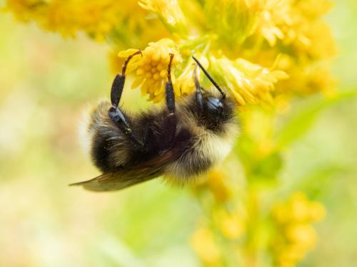
Honeybees tend to outcompete native bees for pollen. Tepedino said, “if you put enormous numbers of honeybees on public lands … the native bee population must, by necessity, be deprived.”

A study by Tepedino concludes that the honeybees in a single apiary can, in just four months, remove enough pollen to raise five to 13 million native bees.

O’Brien said that competition is also worsened by climate change. Because climate change leads to more drought and as a result fewer flowers, it is becoming more difficult for native bees to compete with honeybees, she said.

Mary O’Brien (a botanist) also said the CE was instituted in the 1980s, before scientists knew very much about native bees. She points to the western bumblebee, a species she said is “critically imperiled” in Utah. It is particularly threatened by diseases, including ones that are transmitted by honeybees.

Project Eleven Hundred was born about five years ago in response to a request for a permit to place 100 hives each at 49 sites in the Manti-La Sal National Forest.  That permit was denied, but there is currently a permit on the Uinta-Wasatch-Cache National Forest that is up for renewal at the end of this year, which is being contested and may be litigated.  Project 1100 has also petitioned to remove the CE.

In forest planning under the 2012 Planning Rule, species of conservation concern are to be designated SCC if there is a risk to their persistence in the plan area.  Both listed species and SCC must be addressed in forest planning to ensure that the plan decisions (components) adequately protect these species from threats.  Since commercial non-native apiaries are a threat to these species, a forest plan should consider, and probably adopt standards that regulate or prohibit issuance of permits for honeybees.  (I’m guessing wild honeybees are found on most national forests.)

The proposed revision of the Manti-La Sal National Forest Management Plan  allows apiaries, subject to a standard stating that permits “shall not be issued for placement of hives within 5 miles of known insect-pollinated, at-risk plant species locations or at-risk insect populations.” It also states that a maximum of 20 hives can be issued for each apiary special use permit (which is arguably “not commercially viable”).  O’Brien said this is an impossible precaution to enforce. “As if they know where [native bees] are,” she said. “…The western bumblebee would be considered at risk, and they don’t know where it flies.”

The western bumblebee was NOT designated as an SCC in the Manti-La Sal’s draft of its revised forest plan.

New to national forests – carbon sequestration

The world’s largest carbon direct air capture facility has started construction in Iceland

From the news release:

The U.S. Department of Agriculture’s Forest Service today announced a Notice of Proposed Rulemaking (NPRM) that would allow the agency to consider proposals for potential carbon capture and sequestration projects on national forests and grasslands. This proposal would harmonize the framework between the federal government’s two largest land managers by aligning with regulatory structures already established for the U.S. Department of Interior’s Bureau of Land Management.

If this amendment is finalized, applications for carbon sequestration on national forests or grasslands would be considered for permanent use. The proposed regulation changes the initial screening criteria to allow the Forest Service to consider proposals for carbon capture and sequestration projects and does not allow for any other permanent uses on national forests and grasslands.

From the Federal Register:

The United States Department of Agriculture, Forest Service (Forest Service or Agency), is proposing to amend its special use regulations, which prohibit authorizing exclusive and perpetual use and occupancy of National Forest System lands, to provide an exemption for carbon capture and storage.

Carbon dioxide injected in pore spaces may remain for over 1,000 years after injection and would be tantamount to an exclusive and perpetual use and occupancy if authorized on NFS lands.

The proposed rule would not authorize carbon capture and storage on NFS lands. Rather, the proposed rule would exempt proposals for carbon capture and storage from the initial screening criterion prohibiting authorization of exclusive use and occupancy of NFS lands, thereby allowing the Forest Service to review proposals and applications for carbon capture and storage and to authorize proposed carbon capture and storage on NFS lands if, where, and as deemed appropriate by the Agency.

Proposals for underground storage of carbon dioxide would have to meet all other screening criteria, including but not limited to consistency with the applicable land management plan, potential risks to public health or safety, conflicts or interference with authorized uses of NFS lands or use of adjacent non-NFS lands.

Of course it would have to be consistent with forest plans, but would a forest plan that authorizes “exclusive and perpetual use and occupancy” of national forest lands be consistent with the Multiple-Use Sustained-Yield Act?  (Is the BLM different in this regard?)  I assume that’s why the existing special use regulations are written to prohibit permanent uses.  Maybe this should be viewed as a question of divesting ownership rather than a permitted special use.


Presidential election has consequences for BLM plan?

The Rock Springs (WY) office of the BLM has recently released a draft of its resource management plan.  The DEIS includes the traditional four alternatives:  no-change, protection, development, and “balanced.”  As Governor Gordon’s natural resources policy advisor put it, “In this case they kind of broke precedent and chose (alternative) B, the most resource-restrictive development.”  A retired BLM employee has alleged that presidential politics played a role.

The most balanced plan for managing millions of acres of federal land in central Wyoming — and the alternative that Bureau of Land Management employees and others put the most time, effort and money into — was rejected by the past two presidential administrations, a retired BLM employee said.

The Trump administration likely would have pushed Alternative C because it favors more drilling for oil, he said.

But the Biden administration has gone to the opposite extreme, so the BLM now is pushing forward with Alternative B, which designates 1.8 million acres as “areas of critical environmental concern” (ACES).

Evans said it’s disheartening that two presidential administrations boosted the plans with the least amount of effort put into them.

“The science and the work to do that was all done on D,” Evans said. “And it’s kind of a shame that what the people in the field office and the cooperators spent all that time doing was rejected.”

Now many of those same BLM insiders who worked for years and spent millions of dollars fleshing out a balanced alternative instead have to push the administration’s preference and sell it to Wyoming residents and officials.

The State of Wyoming is considering suing over the plan (even though is not final yet).  Road management and minerals are key issues.

Based on my experience, I would agree that there may not be a precedent for selecting the most resource-restrictive land management plan alternative .  I also have not seen this level of direct political involvement in picking an alternative in Forest Service planning.  Typically in the Forest Service, any political “wants” would be built into the “balanced” alternative that would end up being selected.  Please let us know if anyone has had a different experience.  (Maybe this is a result of the different structures and cultures of the Forest Service and BLM.)
I have mixed feelings about this approach, where all but one are essentially straw alternatives.  Legally, all action alternative must be given equal treatment in the effects analysis, but that doesn’t preclude more serious thought being put into to the design of one alternative.   If one of the others is actually selected it would create the problem the employee described here – it has to be prettied-up at the end of the process.  I think it is important to meaningfully evaluate all reasonable alternatives, but there is a difference between “reasonable” meaning “what would meet the purpose and need” and “reasonable” meaning, “what the agency could realistically select.”  I think what is missing from public disclosure is the actual iterative alternatives that are considered in building the preferred alternative.
On October 9, the BLM extended the public comment period to January 17.  I guess that would buy them more time to refigure out the details of this alternative, or as they point out “In any resource management planning process, the final plan may mix and match portions from all the alternatives.”   “Rebalancing” them I suppose.

Over the Weekend – Blue Mtn. blues, Flathead secrets and monumental benefits

I guess this is a bookend to Sharon’s “Friday News Roundup.”


BLUE MOUNTAINS

I recently provided an update on the status of the Blue Mountains forest plan revisions here.   And here’s a little more detail on that, especially on the question of “access.”  (This term gets used for a couple of different things, and this one is about closing roads on national forests rather than creating access across private property to reach public lands.)

One group says its leading the charge to fight for what they call “original rights” is Forest Access for All.  “We defend the rights that we’ve had since Oregon was a territory, free reign where we go and utilize the forests which are public lands,” says Bill Harvey, a group member and former Baker County Commissioner. “A couple decades ago the Forest Service began closing off sections of the forest and that’s when Forest Access for All was formed.” Harvey says his group’s particular ire is at the Wallowa-Whitman National Forest (WWNF), which he claims “have closed thousands of miles of roads in the forest the last twenty years.”

The group also has other “conflicts” with the Forest Service include the need for  more vegetation management, economic benefits of (motorized) recreation, and better public engagement.

“By law right now, we have an open forest. They will admit it, everybody admits it, and it’s in the books, I’ve seen it a million times. It is an open access forest,” says Harvey. “Why in God’s name would we want to give that up? Nothing benefits us to give up our rights that we have currently. We’re not asking for more rights, we’re asking for the existing rights to stay in place.

I’m going to disagree with him on this one, and I hope the Forest Service does, too (although it looks like they could have done a better job of setting the locals straight on this before now).  In 2005, Subpart B of the Travel Management Rule changed the culture of motor vehicle use on roads, trails, and areas from “Open unless closed” to a system of designated routes.  As for why?  The goal was to reduce resource damage from unmanaged motor vehicle use off that road system.


FLATHEAD

Newly revealed emails show that the Flathead National Forest under then supervisor Kurt Steele looked to keep a proposal of a tram up Columbia Mountain from public view for more than year prior to it being first proposed.

Does this sound familiar?  It sounds to me like the “Holland Lake Model” that got the forest supervisor a “promotion” to forest planning.  In this case the Forest properly rejected the proposal as inconsistent with its forest plan (thank you forest plan!).  But it does suggest a pattern of incentives and behavior that may be broader than the Flathead National Forest.

“The process where the public comes into play is when it becomes the NEPA process,” Flathead Forest spokesperson Kira Powell said about the emails.

“Bringing you into the conversation about this potential project on the Flathead NF because it’s coming from investors who apparently have the financial resources to build a tramway, meaning they likely have political savvy also … wrote Keith Lannom, who was deputy regional forester for Region 1 at the time …”

This account offers a window into the role of “political savvy” in Forest Service decision-making.


ORGAN MOUNTAINS – DESERT PEAKS NATIONAL MONUMENT

Since President Barack Obama created the Organ Mountains-Desert Peaks National Monument in 2014, visitation has tripled and the national monument has spurred economic growth in the Las Cruces area as well as other communities near the national monument, according to a new report.

According to this overview, the report looks at the various factors that made this particular monument so successful, including its location relative to population centers and the uses it caters to.  Also local community support.

“We have always recognized that the establishment of the monument was due in large part to the grassroots effort at the local community organizations and individuals,” Melanie Barnes, the state BLM director, said. “And due to this engaged and proud community, the monument has seen an increase in visitation.”

She said the BLM is working on a resource management plan that will address land use and resource protection. The public scoping period for that plan recently ended.


Forest Plan Revision – fall 2023 roundup

Once upon a time, in a city far away, the U. S. Forest Service posted its schedule for revising national forest plans on its national website.  There was even a map showing the revisions completed under the 2012 Planning Rule.  Today, they are not where they used to be on the website, and I couldn’t find them anywhere else.  Maybe they didn’t like what I (or others) were doing with the information?

The last schedule that I saved was from May, 2022.  I have compiled the current information on the plans listed in that schedule and a few others that I am aware of below, roughly in order of their status, from those completed to those just starting.  I counted 14 completed and 16 officially ongoing revisions (if I have missed any, let me know).

COMPLETED REVISIONS

These plans were completed prior to May, 2022

  • Francis Marion (2017)
  • Flathead (2018)
  • El Yunque (2019)
  • Inyo (2019)
  • Chugach (2020)
  • Rio Grande (2020)
  • Helena-Lewis and Clark (2021)
  • Custer-Gallatin (2022)

The American Bar Association recently provided this favorable critique of the El Yunque revised plan.

No policy better reflects the agency’s increased awareness about the importance of understanding and utilizing local stakeholders than the 2019 plan’s “all-lands” management approach, which aims to bring landowners and stakeholders together to identify common goals for the forest.

These plans have been completed and adopted since May, 2022

  • Carson (July 8, 2022)
  • Cibola (July 15, 2022)
  • Santa Fe (July 29, 2022)
  • Nantahala Pisgah (February 2023)
  • Sierra and Sequoia (May 2023)

Here is a commentary from Wild New Mexico on the three New Mexico plans.  The Sequoia revised plan is discussed in this article.  We discussed the Nantahala Pisgah possible lawsuit here.

It’s worth noting that lawsuits against these revised plans have been scarce.  The Flathead has had two (one is discussed here)  and there is a case currently pending against the Rio Grande (discussed here).  Have I missed any?  (The Colville revised plan litigation, discussed here, was developed under the previous planning regulations.)

PENDING REVISIONS (header links are to the Forest Service web page)

  • Tonto – objection instructions letter

On May 19, 2023, the Regional Forester issued her final instructions to the Tonto Forest Supervisor and responded to the eligible objectors. These final instructions included changes the forest must make to the final plan or supporting documents before the Forest Supervisor may sign the Record of Decision and implement the new plan.  Some additional information is in this article.

  • Ashley – FEIS/plan objections

The objection filing period ended June 20, 2023. The Forest Service received objections from 14 individuals or organizations.  An objection resolution meeting was scheduled for August 28.

The proposed final plan and FEIS were released August 30 and the objection period runs until October 30.  A couple of articles covered the release – here and here.

The draft EIS was released in December, 2019.  The FEIS is listed as “Proposed” “Summer 2023.”  However, a recent article is now saying “by the end of the calendar year.”

  • Gila – draft EIS completed

The official 90-day comment period for the draft documents ended April 16th, 2020.

The draft plan and EIS were available for public comment until November 2021.  Local news suggests it’s not going smoothly:  “Personally I believe you are trying to do the best that you can,” Jeff Bilberry, chairman of the Chaves County Board of Commissioners, said to Forest Service representatives. But he added soon after, “I am going to agree with former commissioner (Will) Cavin that we need to go back and start over again and let’s do this right so we don’t have everybody sitting here wondering what is fixing to happen.”

The Manti-La Sal National Forest released its proposed Land and Resource Management Plan and DEIS on Aug. 18. Public comments on the DEIS are being accepted until November 16.

In September 2019, Forest Supervisor Chuck Mark announced the Salmon-Challis National Forest will evaluate the 1988 Salmon Forest Plan and the 1987 Challis Forest Plan separately. A new timeline will be developed once public feedback has been gathered to inform steps moving forward.

Public comments on the draft assessment were sought last summer.

  • Lolo – draft assessment completed

Public meetings are ongoing to discuss the final assessment, need for change and developing the plan.  A Notice of Intent to prepare an EIS is currently expected in January, 2024.

The Bridger-Teton National Forest aims to have the draft assessment report available for public review by late fall per this article.  (And they are getting some help.)

  • Blue Mountains (Malheur, Umatilla, and Wallowa-Whitman) – restarting assessment

The most recent effort to revise the plan failed in 2019, and now the Forest Service is restarting the process, beginning the assessment process in June and public meetings are scheduled for this fall.  Some background is provided here.

No forests in the area covered by the Northwest Forest Plan have formally started the revision process.  A Bioregional Assessment was prepared in 2020.  Based on the Bioregional Assessment findings, land management plans may be amended or revised at the same time or in groups according to common features like geography and ecosystems.

The most urgent need is to restore fire’s natural role in the frequent-fire dependent ecosystems closest to communities in the eastern Cascade Mountains, Klamath Mountains of southern Oregon and northern California, and the southern Coastal Mountains.

Based on that urgency, a cohort of northern California units and the Rogue River-Siskiyou National Forest in Southern Oregon are being considered as the first to begin plan modernization. Northern California cohort includes the Klamath and Butte Valley Grassland, Six Rivers, Shasta-Trinity, and Mendocino National Forests.

OTHER “PROGRAMMATIC” DECISIONS

On August 21, the Forest Service proposed to change the name of the Wayne National Forest in Ohio to the Buckeye National Forest.  The national forest is currently named after General (“Mad”) Anthony Wayne, whose complicated legacy includes leading a violent campaign against the Indigenous peoples of Ohio that resulted in their removal from their homelands. Buckeye National Forest is one of the names suggested to the Forest Service by American Indian Tribes.  But of course, Republicans have politicized it.


Bitterroot Front Project draft

The Bitterroot National Forest is going to try out “condition-based” NEPA with the Bitterroot Front Project.

The project anticipates 54,046 acres of prescribed burning alone; 35,575 acres of non-commercial logging coupled with prescribed burning for whitebark pine restoration; 27,477 acres of commercial logging with prescribed burning; 16,019 acres of vegetation slashing and burning; and 3,163 acres of non-commercial logging and prescribed burning… It will take dozens of miles of roadwork to do all that.

The project is expected to take four years.  “Condition-based” means they don’t know where any of these things are going to happen until they get there.  From the EA, as the project proceeds …

Information about proposed activities, including maps, treatment unit tables, and the activities’ relationship to the Bitterroot Front project’s overall treatment thresholds, would be available on the Bitterroot National Forest website. The responsible official would finalize proposed activities only after field review of existing conditions. The responsible official would retain the authority to make final decisions about the location, extent, and types of activities planned and completed under the Bitterroot Front project.

Nothing said here about the process they’ll follow to evaluate and disclose that new information they find when they get there, in particular about site-specific effects. They seem to be taking the position that “this is it” for NEPA compliance:

By preparing this environmental assessment (EA), the Forest Service is fulfilling agency policy and direction to comply with the National Environmental Policy Act (NEPA) requirements and to determine whether the effects of the proposed action may be significant enough to require the preparation of an
environmental impact statement (EIS).  (EA, p. 1)

The EA says, “if an EIS is required, the Forest Service will prepare an EIS consistent with 40 CFR section 1501.9(e)(1).”  I know this is the theory, but how often does a draft EA get redone as a draft EIS after public comment makes the case for significant effects?  Usually the agency makes that call early enough to not create the extra step of an EA.   The agency has plenty of examples of timber sales much smaller than this that had “significant” environmental effects documented in an EIS, but they seem kind of committed to an EA.

This years-long project is being pursued under emergency authority, so there will be no administrative review.  So if the Forest stays this EA course here, the emergency determination would allow local officials to make the call on whether they think this EA would hold up in court.

The “implementation plan” in the EA says that the obligation during implementation is to “Demonstrate that the effects of implementation would be within the scope of activities and the range of effects described in the EA and authorized in the Decision Notice.”  This would be an effects analysis, which would trigger consideration of NEPA.  It could answer the question of whether the effects have become significant (triggering an EIS for the whole project), but apparently is not intended to address the question of whether the site-specific effects have been accounted for pursuant to NEPA after the locations and treatments are known, and whether they are “consequential” (in a NEPA sense).

Where courts have approved of approaches like this it has been where the “conditions” are very specifically defined in the initial decision so that there is not much flexibility in implementation and the site-specific effects can be determined and evaluated.  It doesn’t look to me like the Bitterroot Front is similar to the two favorable court examples I’ve read, but it does feel like the familiar pushing of the envelope to see how far they can take this approach.

So, while I think an EA (with no administrative review) in these circumstances seems like kind of an outrageous idea, I actually wanted to focus on another familiar issue this article brings up:

Critics of the proposal argue that the significant removal of vegetation — including live trees and brush and standing and downed dead timber — will actually promote wildfire spread by allowing uninhibited wind to whip flames through opened-up forest that’s been dried by more wind and sun penetration…

A body of science supports the idea that “forest treatments” — a regime of logging, thinning and burning — can reduce wildfire risk on a landscape and make firefighting efforts more successful. But critics of widespread forest treatments can point to other studies that cast doubt on their efficacy, and on the idea that forests in western Montana used to be dominated by spread-out Ponderosa pine with frequent low-severity fire.

I hope the EA has a good discussion of the science on both sides.  But that last point is a new one to me.  Several national forests in Montana with dry forest habitats have revised their forest plans, and included desired vegetation conditions, which are supposed to be derived from historic conditions.  I don’t think I’ve heard much disagreement with establishing “spread-out Ponderosa pine with frequent low-severity fire” as a desired condition for places similar to the Bitterroot.  Have I missed something?  (Or did the author misinterpret something?)

Here’s what I find in the EA (based on “a geospatial analysis of the Bitterroot Front project area to prioritize communities at risk from large wildland fire growth”):

Modeling results of the current conditions within the project area show that the forest is at extreme risk of a catastrophic fire. The modeled outputs from the present fuel arrangement conditions do not mimic the natural fire spread type for sustainable ecosystem management in the Bitterroot National Forest.

Part of the proposed action is:

Restoring and maintaining ecosystem health by continuing to move the fire regime condition class toward the desired future condition through continued treatments that create disturbance.

Most of the discussion in the EA seems to be about the existing fire risk rather than whether that risk is “natural fire spread type.”  According to the Vegetation Specialist Report, “Overall, the desired future condition includes forest structures, composition, and processes that would have been present historically.  It proceeds to offer a description of “warm/dry” and “cool/moist” vegetation types.   If there are truly disagreements about the desired condition of vegetation or fire regime for these types or areas, alternatives should be considered.  (Under the 2012 Planning Rule, these desired conditions should be found in the forest plan.)

Then there is the question of, “whether the forest plan should be amended for elk habitat objectives, snags, old growth, and coarse woody debris standards to accomplish the project objectives.”  This all comes off looking like they are revising their (very old) forest plan for half of the forest, with new desired conditions and standards, using a project EA.


House of Representatives v. BLM – monuments and the public lands rule

Grand Staircase – “visitutah.com” (Larry C. Price)

Dismissal of a lawsuit against President Biden’s proclamation restoring the boundaries of the Grand Staircase and Bears Ears national monuments allows the NEPA process to develop a management plan for these areas to proceed unhindered.  Biden ordered the BLM to work on replacing the Trump Administration’s resource management plan, and the BLM published its draft RMP on August 11 for public comment.

BLM may proceed unhindered, that is unless Congress decides to hinder them.  The FY2024 Interior, Environment, and Related Agencies Bill the House Appropriations Committee passed in July, which the full House of Representatives is expected to vote on in September, includes a rider that would require the BLM to manage the Grand Staircase NM in accordance with the plan finalized after Trump reduced the monument.

Which is the better planning process – RMPs based on public involvement through NEPA or RMPs based on appropriations riders?

The bill would also deny funding to implement the BLM’s public lands rule (a popular topic with many posts here from Sharon).  Another bill would force BLM to withdraw the rule (without considering all those public comments).

Kya Marienfeld, wild lands attorney for SUWA, called the Utah congressional delegation’s lack of support for the state’s public lands disappointing but adds that opposition is offset by more enlightened members of Congress who actively support the Grand Staircase and other public lands.

Appropriation riders seem to be kind of crap-shoot in the turmoil of budget negotiations, so I have no idea what the betting line would be on President Biden signing off on this one.  The “more enlightened members of Congress” may have more of an influence on defeating the withdrawal proposal.  Is that a bad thing?


Surprise! Not: Lawsuit Filed on Pisgah-Nantahala Plan and the Prophetic Andy Stahl

Normally, this is Jon’s area,  but I thought that this is an interesting example.. just on the forest planning side.  Apparently forest planning has been going on since 2014 (for almost 10 years) to make a 15 year plan.. which should be a “30 year plan” according to this article.  And of course, there will be many changes in those  years from climate and other factors, and hopefully the plan will be flexible enough to adapt to these new situations or be easily amended.

In the notice of the lawsuit, filed Wednesday, lawyers for the Southern Environmental Law Center say the forest is home to 28 federally listed endangered and threatened species, as well as 29 other species that are candidates for that recognition. Many of those species have declined dramatically over past decades and require more stringent protection than the final forest plan offers them.

“For example, the northern long-eared bat, which relies on mature forested habitat in the [forests], has declined by more than 90% over the past few decades,” attorneys for the SELC said in the notice. “These declines should not be secondary considerations, subordinated to timber or game wildlife management. Instead, reversing these declines is central to the Forest Service’s mission.”

The filing also alleges that the Forest Service years ago provided incomplete or incorrect information to the U.S. Fish and Wildlife Service, which subsequently issued an official opinion that the additional logging planned would have little impact on the listed species.

“We cannot sit back while this irresponsible forest plan ignores the science, breaks the law, and puts these remarkable species at risk.” Sam Evans, leader of SELC’s National Forests and Parks Program, said in a news release. “Forest plans are revised only every 20 years or so, and our endangered bats won’t last that long unless we get this plan right.”

I am reminded of a prophetic statement by Andy Stahl here on The Smokey Wire in 2011.

The big difference between the old (1982) rule and the new proposal is that the new eschews any pretense of “rational” economic planning. The old rule regarded the national forests as factories of goods and services from which planners could divine, with the help of linear programming models, an optimum allocation and schedule of harvests. Each output was assigned a value; each input was assigned a cost. When the model didn’t give the desired answer, planners tweaked the numbers. When the tweaks didn’t work, planners made-up the numbers.

The edifice came crashing down in the late 1980s. A quarter-century later, the Forest Service is still digging itself out from under the rubble.

The new rule replaces economic rationality with ecological rationality. The old gurus (e.g., Krutilla, Hyde, Clawson and Teeguarden) have been deposed by Soule, Ehrlich, MacArthur and Wilson. Leopold is the new God (is it coincidence that the Forest Service released this month a new Leopold biopic?); Pinchot is history.

Perhaps ecologically rational planning will be more successful. But I doubt it. The new forest planning process still pits bitter ideological enemies against each other with the Forest Service serving as self-interested arbiter. The modern-day critic will turn from deconstructing FORPLAN to deciphering HexSim. Every plan will be appealed and most will be litigated.

Perhaps in another quarter-century the FS will abandon any pretense of rational comprehensive planning and consider the incremental, on-the-ground K.I.S.S. approach I suggested. I should live so long.

Andy’s comment was in a post on Pete Nelson’s views on the wildlife provision, posted by our old friend Martin Nie.  And now Pete has been hired by the Forest Service to help with policy options for MOG..  and folks are writing in about needing Martin’s specific triggers determined beforehand based on monitoring, and the Forest Service circle of planning to plan continues…

Personally the biggest problem I see is the tension between “with climate unknown emergencies could arise at any time, forests will burn up and or convert to grasslands or brushfields and management will need to be flexible with these unforeseen futures” and “we need planning that’s based on ideas from the past (reference conditions) and is highly structured with many many sideboards. ” Maybe the conversation we need to have is… why don’t you trust federal employees to make the right conservation decisions in the moment? Can we have both, flexibility and trust, without lengthy and protracted exercises that are just another opportunity for “ideological enemies” as Andy says, to attempt to renegotiate previous agreements?

Pew Report: Check Out Their Mapping Tool for Your Area and Some Ideas for Co-Designed Co-Produced Research and Monitoring

This is a map of total carbon southeast of Roxborough State Park. Yellow is lots, black is not much (hover over each indicator to see what the colors mean).

Steve posted about this Pew piece yesterday, so I thought I’d take a closer look. He quoted:

The USFS can better incorporate climate change-ready practices in four ways.

1) Use the best available science.
2) Identify specific climate change-ready management tools.
3) Monitor and adapt to changing conditions.
4) Engaging communities and Tribes.

I think the FS is already doing all those things.. so wondered if Pew had any different views. Let’s look at #1. Use the “best available science.”

New management approaches adopted by the Forest Service should encourage the continual incorporation of sound scientific and climate-informed information, as well as collaboration among the agency, Tribes, governments, and stakeholders in the design and development of new research projects to address identified knowledge gaps.

To support this management approach, The Pew Charitable Trusts and Conservation Science Partners (CSP) have released new research that can be used to help inform management decisions with climate change effects in mind, an approach known as climate-ready management. This publicly available data can be viewed with a user-friendly, interactive web map. Designed with input from USFS, the research identifies:

  • Areas of relatively high ecological value (HEVAs), such as places with high biodiversity, resilience to climate change, and significant carbon storage. Such prime locations would contribute most to sustaining forest health if managed with conservation as a priority.
  • Areas where proactive forest management projects would mitigate the risk of large, severe wildfires, which would help to protect communities, ecologically valuable areas, and the provision of ecosystem services.

Together, this data can improve return on investment by identifying places where the right management or the right activities will provide the greatest set of benefits across multiple considerations.

It seems to me that these data would have been improved by “collaboration among the agency, Tribes, governments, and stakeholders in the design and development of new research projects to address identified knowledge gaps.”  Perhaps the HEVA mapping effort is putting the cart before the horse? In fact, it seems like the “right management” and the “right activities” to provide the “greatest set of benefits” is exactly what the forest planning effort is designed to do.. via throwing different approaches, data, observation, and kinds of knowledge around and discussing it.  And maybe jointly, as Pew suggests, investigating new lines of research.  Perhaps Pew could fund some co-designed, co-produced research in support of each forest’s collaborative groups- so take those less  privileged forests (no CFLRP) and provide that capability to them? Similar to the Blue Mountain Forest Partners.. and no need to schedule a plan revision. Pew could help forests develop their own research and monitoring with stakeholders.

**********************

How Useful is This Mapping Exercise? Open Ground-truthing Exercise

I encourage everyone to play with the mapping tool and the indicators for their own area. Here’s the link.  Please comment on what you found for your own area. Check out their Protected Areas and IRA “context” layers, if I read them correctly in my area, they look a little odd.

Anyway, you can check out this spring report from Pew on how protecting high value forest in Colorado can secure over $1.2 billion annually in ecosystem services. It sounds like each NF has had such a report developed.  Maybe recent revision forests can weigh in on whether there were any new insights derived from this way of looking at the forests.

Pew seems to suffer from a degree of plan-olatry:

Updating these plans will also benefit local communities. NFS lands received a record 168 million visits in 2020, an increase of 18 million from the previous year. These visitors contribute approximately $12.5 billion to the U.S. economy each year and support about 154,000 full- and part-time jobs. But this growth in visits also carries challenges, particularly for the wildlife that live in these places. Revising forest plans can help balance where and when tourism and recreation activities are occurring and ensure that infrastructure, such as functional trailhead facilities, supports human visitors and healthy wildlife habitat.

********************

The rest of the recommendations sound like things the FS is already doing..

2) Identify specific climate change-ready management tools.

Using the best available science, the Forest Service should identify specific strategies to help ecosystems and species resist or adapt to the impacts of climate change and related stressors. Such strategies include:

  • Directing managers to prioritize HEVAs—after considering other important social and economic considerations—for strong conservation-oriented management. (not to speak of Tribes, resource professionals, and community involvement)
  • Promoting connectivity by retaining or restoring migration corridors for species such as mule deer. (the FS works with state wildlife agencies on that)
  • Replacing or removing culverts to allow aquatic species to move throughout streams.(hydrologists and fish bios do this regularly)
  • Restoring forests to their historic mix of young, mature, and old forest types where today’s conditions differ. (NRV, but with litigation from some ENGOs when it involves tree-cutting)

3) Monitor and adapt to changing conditions.

To understand the impact of management choices and trends of ecological conditions, the agency should develop more robust monitoring policies that regularly measure key indicators, such as annual rainfall and population of key species. Monitoring is critical and when science indicates a needed change, the USFS must pivot to incorporate a new management direction in a timely manner. Updated forest plans can serve as the starting point for this adaptive management approach.

(Like I said above, Pew could fund this by helping stakeholders ( a la Blue Mountain Forest Partners) develop research and monitoring; the adaptation by the FS can occur organically with that jointly developed information.)

4) Engaging communities and Tribes.

During the development of management plans, project design, and monitoring programs, the USFS must reflect the needs and desires of communities and Tribes that have a connection to national forests. Such meaningful engagement at every step of these processes will increase the quality and durability of the results.

(I think the FS already does this.. but communities and Tribes can disagree among themselves and with each other. Pew could model this by with involving communities and Tribes in developing ideas and measures for areas they want specially protected perhaps for HEVA 2.0.)

*************************************


Sequoia and Sierra Forest Plans- E&E News Story

This is a long and comprehensive story but I can only quote excerpts, sadly, due to the paywall. I’ll highlight a few points..

The title of the article is “In California forest plan, a hint of climate fights to come.” They seem like the same old fights to me, but with climate issues as a new set of arguments (carbon sequestration, leave them alone vs. if we leave them alone lots of good things, including them, will burn up). Can you imagine a forest plan that says “since most people who recreate on the national forests currently use oil and gas products to get there, or charge their vehicles using electricity at least partially sourced from fossil fuels, we are ceasing recreation except for those who can prove they charge with their own solar panels”.. now that would be a real “climate” fight. Not “let’s thin trees or not.”

For all the rhetoric politicians and policymakers throw at the nation’s growing wildfire crisis, real-life changes in managing the nation’s fire-prone forests are about to play out in a series of dry documents found on the Forest Service website.
These are the land management plans federal law requires the Forest Service to update every 15 years — a deadline that’s rarely met — across the nation’s 175 national forests and grasslands. Two recently completed plans in California reflect the agency’s growing emphasis on climate change as it revises the plans, as well as the hurdles the federal government faces in tackling changing conditions throughout the landscape.
Drafted over the course of a decade, the updates for the Sierra and Sequoia national forests took so long that wildfires tore through some of the areas in question and severe drought killed trees in others, forcing further revisions by forest managers.
“Scientists estimate, based on data collected between 2012 and 2019, that there are now approximately 60.2 million dead trees in the Sierra and Sequoia National Forests killed by drought, insect, and disease,” said Forest Supervisor Dean Gould in the agency’s record of decision in May.

How many times have we pointed out that the plan revision process can’t keep up with real-world changes? It’s too grandiose and unwieldy. Even the Committee of Scientists suggested a loose-leaf notebook approach instead in 1999.

The Forest Service has a total of 128 management plans. Of those, 99 are more than 15 years old, meaning they’re overdue for revision, according to the Forest Service.
Worsening drought and wildfire are pushing the Forest Service toward a more intensive approach, through cutting and removing trees and increasing the use of fire as a tool to naturally reduce potential fuel. The plan update embraces letting some naturally occurring fires burn with monitoring, for ecological benefit — a practice that’s drawn criticism from some groups and Republican lawmakers.

What all sides appear to agree on is that the updated plans in California carry broader lessons for forests throughout the West.

I think the use of managed fire or WFU is a broader policy than what’s in forest plans, since it occurs in many places. And I don’t know any forest plans that don’t allow fuel treatments.  And the GMUG did a fire use amendment so it doesn’t seem necessary to revise to update. Does anyone know exactly what the SS plans do differently specifically on Managed Fire/WFU?

The forest plans for the Sierra and Sequoia, as well as the nearby Inyo National Forest, were among the earliest to go through a process spelled out in a 2012 federal forest planning rule that was supposed to make the process faster and in collaboration with the communities around them. The Sierra and Sequoia updates have good provisions, said Susan Jane Brown, a principal attorney with Silvix Resources, an Oregon environmental law firm specializing in forest issues — but they weren’t in place to deal with the fires and other challenges that arose during the drawn-out revision.

“The fact that it still took the Forest Service more than a decade to get these forests across the finish line is pretty hard to stomach, especially given that part of the selling point of the 2012 rule was to get plans done in two to three years,” Brown told E&E News.

Whoa! Let’s see if we think of the FS as a pack mule, the 2012 Rule was loading the mule up with more weight, assessments, analyses of NRV, and so on.  I don’t know exactly where optimism becomes untruth, but many of us thought that that statement (that plans could be done in two to three years) was quite a ways over the untruth line.  I don’t believe anyone believed that you could put more weight on the pack mule and somehow magically it would move faster.

The revisions in California illustrate the need for regular updates to forest management plans, Brown said. But the Forest Service is slowed by staff turnover, and Congress for years has freed the agency of a legal requirement to update plans every 15 years, through a provision that appears in annual appropriations bills.
“In my experience at the collaborative table, stakeholders are desperate for updated, science-based plans: Most of us are working with plans written in the late 1980s or early 1990s, which were based on information gathered in the 1970s,” Brown said.

My experience, living next to a Forest with a very old plan, is that they are not hindered from doing what needs to be done. Because each plan for actually doing something on the land requires updated info.    It seems after 11 years, the Admin could set up a new Planning FACA Committee to review 2012 Rule implementation, something like the EADM effort with partners who had been involved in plan revisions.  Responding to climate change, both mitigation and adaptation,  requires flexibility. Forest planning is a relic of the planning mindset of close to 50 years ago.

If the updates in California are any indication, forest plan revisions aren’t about to resolve some of the thornier debates about how best to manage forests in the face of climate change. Two questions continue to challenge forest managers: Are relatively frequent high-intensity fires normal in the region, and does thinning and logging forests pose a greater, or lesser,
risk to spotted owls than wildfire?

This is kind of my Pandora’s box argument; a plan revision is an opportunity to open Pandora’s Box of all the disagreements people have, and are working on, project by project. And, does the fact that Chad Hanson disagrees make something a “thorny” debate?

And yes, the Forest Service has a new planning implementation model to speed things up which I described here in 2021. I was never able to access any write-ups describing it, so if anyone has those, please email me.

Last but certainly not least, here’s a big shout-out, congratulations and thank you (!!!) to the folks on the Sierra and Sequoia Forests for having completed their plan revision!
And to those stakeholders, partners and plain old members of the public who kept with it, especially those who weren’t paid, and read those documents anyway.